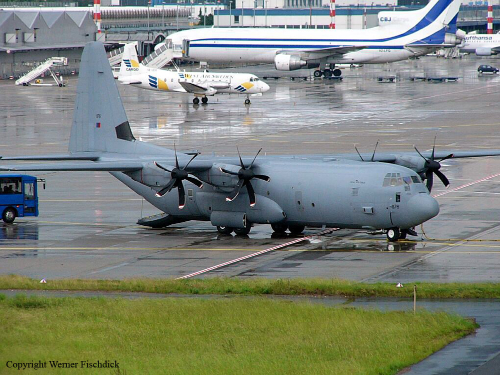
Crash of a Lockheed C-130J-30 Hercules in Amarah

Date & Time: Feb 12, 2007 at 2010 LT
Type of aircraft:
Operator:
Registration:
ZH876
Flight Type:
Survivors:
Yes
MSN:
5460
YOM:
1999
Country:
Region:
Crew on board:
6
Crew fatalities:
Pax on board:
58
Pax fatalities:
Other fatalities:
Total fatalities:
0
Circumstances:
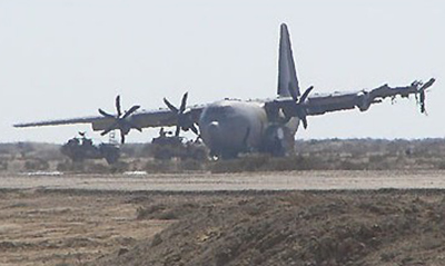
The crew of ZH876 were tasked to fly a routine roulement of troops to a Tactical Landing Zone (TLZ) in Maysān province, Iraq. Weather at the TLZ was good, with a visibility of 25 km, no significant cloud and a light surface wind. The flight to the TLZ was routine and at approx 17:00 UTC the Hercules began to make its approach to the TLZ. Comms had already been established between ZH876 and the Tactical Air Traffic Controller (Tac ATC) at the TLZ, and the aircraft was subsequently cleared to land. An uneventful approach followed flown by the copilot. At 17:10:15 UTC, as the aircraft was about to touchdown at the TLZ, the crew experienced a load bang and a bright flash. The flash temporarily blinded the flight-deck crew. Virtually simultaneously, the aircraft touched down. The first flash was followed, a second later, by another flash and louder bang. The aircraft slewed off the left-hand side of the runway. The captain took over control of the aircraft. On regaining vision, the captain tried to steer the aircraft back onto the runway. However, the crew became aware of a fire on the port side, which was confirmed as a wing fire. The captain brought the aircraft to an immediate halt. The aircraft came to rest 50 m from the runway edge, some 700 m after touchdown. The aircraft sustained substantial damage and it was decided to blow up the plane because the damage was too difficult to repair and there was also a potential risk that anti-Iraqi forces might obtain information on specialist equipment.
Probable cause:
The evidence recovered from the incident site revealed that two IED [improvised explosive device] arrays had exploded in the near vicinity of ZH876's touchdown point at the TLZ. The Board quickly ruled out aircraft systems failure and other possible causes. The Board concluded that this deliberate enemy action was the sole cause of the damage sustained to ZH876 in this incident. The Board further concluded that there was a lack of understanding, by the Force Protection personnel, of TLZ sweep procedures and they had not received the appropriate training. This meant that the sweep procedures applied at the TLZ were inadequate to discover the IED arrays.

Crash of a Cessna 414 Chancellor in Rocksprings: 2 killed

Date & Time: Feb 9, 2007 at 1715 LT
Type of aircraft:
Operator:
Registration:
N69845
Survivors:
No
Schedule:
Houston – Rocksprings
MSN:
414-0637
YOM:
1975
Crew on board:
1
Crew fatalities:
Pax on board:
1
Pax fatalities:
Other fatalities:
Total fatalities:
2
Captain / Total flying hours:
2212
Aircraft flight hours:
5466
Circumstances:
The 2,212-hour instrument rated commercial pilot collided with terrain while circling to land after completing an instrument approach to an uncontrolled non-towered airport. The airport had two instrument approaches to Runway 14; a VOR and a RNAV(GPS). The published minimums for a circling approach to Runway 32 are a 500 foot ceiling and one mile visibility (VOR14) and a 700 foot ceiling and one mile visibility for RNAV(GPS) to Runway 14. The weather at the airport at the time of the accident was reported as 300 overcast, visibility of 3/4 of a mile in mist, with winds from 020 degrees at 10 knots gusting to 14 knots. Two witnesses reported that the airplane circled over the airport and then descended straight to the ground. Radar data revealed that after the airplane made the instrument approach to Runway 14, at approximately 2,800 feet mean sea level (msl), the airplane initiated a circling turn to the left and a slight descent. The last radar hit showed the airplane at 2,600 feet at a groundspeed of 186 knots. A post impact fire consumed some of the airframe. The pilot's logbooks were not located during the course of the investigation and his instrument experience and currency could not be determined. The pilot was reported to be very familiar with the airport and the 2 instrument approaches. A detailed examination of the wreckage of the airplane failed to reveal any anomalies with the airframe, structure, or systems. Flight control continuity was established at the accident site. The engines were examined, and no mechanical anomalies were found. The propellers were shipped to the manufacturer's facility for examination and teardown. Both propellers were rotating at the time of ground impact. Neither of the two propellers was found in the feathered position. Blade damage was consistent with both propellers operating under power at the time of impact. No mechanical defects were noted with either propeller.
Probable cause:
The pilot's failure to maintain clearance with terrain. Contributing factors were the below approach/landing minimums weather and the drizzle/mist weather conditions.
Final Report:

Crash of a Beechcraft H18 in Great Bend: 1 killed

Date & Time: Feb 9, 2007 at 0850 LT
Type of aircraft:
Registration:
N45GM
Flight Type:
Survivors:
No
Schedule:
Wichita - Great Bend
MSN:
BA-717
YOM:
1965
Crew on board:
1
Crew fatalities:
Pax on board:
0
Pax fatalities:
Other fatalities:
Total fatalities:
1
Captain / Total flying hours:
3250
Captain / Total hours on type:
125.00
Aircraft flight hours:
7702
Circumstances:
Prior to the flight, the pilot obtained a weather briefing which included an AIRMET for IFR conditions and an AIRMET for icing that was "just off to the north." According to air traffic control (ATC) information, the en route portion of the flight was uneventful. ATC cleared the pilot for an ILS approach to runway 35, and the pilot acknowledged the approach clearance. When the airplane reached the outer marker ATC approved the pilot for a frequency change to the common traffic advisory frequency. The pilot acknowledged the frequency change, and no further communications were received from the pilot by ATC. Witnesses observed the airplane approximately 200 feet above ground level (agl) on a northwesterly heading, west of runway 35. The airplane then entered a climbing left turn to the south and disappeared into the overcast cloud layer. Shortly thereafter, the witness observed the airplane in a "20 degree nose down, wings level attitude" on a southeasterly heading. The witness then lost sight of the airplane due to hangars obstructing his view. At the time of the accident, the witness stated that the ceiling was approximately 500 foot overcast with mist. The published missed approach procedure instructed the pilot to initiate a climbing left turn to a fix and hold. Examination of the accident site revealed the airplane impacted the terrain in a right wing, nose-low attitude. No ground impact marks were noted except in the immediate vicinity of the wing leading edges, engines, and propeller assemblies. The flaps and landing gear were in the extended position. The leading edge surfaces of the vertical and horizontal stabilizers revealed 1/4 to 1/2 inches of clear ice. The upper fuselage antenna displayed 1/4 to 1/2 inches of clear ice. Local authorities reported observing a "layer of ice" on the leading edges of both wings when they arrived to the accident site. Examination of the airframe and engines revealed no anomalies that would have precluded normal operations.
Probable cause:
The pilot's failure to maintain aircraft control during the missed approach which resulted in an inadvertent stall and impact with terrain. A contributing factor was the icing conditions.
Final Report:

Crash of a Cessna 208B Grand Caravan in Alliance

Date & Time: Feb 8, 2007 at 0225 LT
Type of aircraft:
Operator:
Registration:
N1116Y
Flight Type:
Survivors:
Yes
Schedule:
Omaha - Alliance
MSN:
208-0368
YOM:
1993
Flight number:
SUB022
Crew on board:
1
Crew fatalities:
Pax on board:
0
Pax fatalities:
Other fatalities:
Total fatalities:
0
Captain / Total flying hours:
3232
Captain / Total hours on type:
226.00
Aircraft flight hours:
7248
Circumstances:
The pilot was dispatched on a nonscheduled cargo flight to an airport other than his usual destination because it had a precision instrument approach, while his usual destination airport did not. The pilot elected to fly to his usual airport, and attempted a non precision instrument approach. The airport had both a VOR and an NDB approach. The NDB approach was noted as being out of service, although there was still a radio signal coming from the navigation aid. The pilot was cleared for the VOR approach, although instrumentation inside the cockpit was found set for the NDB approach, and radar track data disclosed that the flight path was consistent with the NDB approach path, not the VOR's. The airport's reported weather was 1.25 miles visibility, with a 200-foot overcast in mist. The airport's minimum NDB approach altitude is 652 feet above touchdown height. The airplane did not reach the runway, and collided with a pole and a building. Inspection of the airplane disclosed no evidence of any preimpact mechanical malfunctions.
Probable cause:
The pilot's descent below minimum descent altitude while on a non precision approach. A contributing factor was a low ceiling.
Final Report:

Crash of a Beechcraft 200 Super King Air in Bozeman: 3 killed

Date & Time: Feb 6, 2007 at 2104 LT
Operator:
Registration:
N45MF
Flight Type:
Survivors:
No
Schedule:
Great Falls - Bozeman
MSN:
BB-234
YOM:
1977
Location:
Crew on board:
1
Crew fatalities:
Pax on board:
2
Pax fatalities:
Other fatalities:
Total fatalities:
3
Captain / Total flying hours:
17608
Captain / Total hours on type:
1318.00
Aircraft flight hours:
5992
Circumstances:
The cross-country flight was on an instrument flight rules (IFR) flight plan, approximately 42 nautical miles from the tower-controlled destination airport, when the pilot was cleared for the visual approach. Dark night visual meteorological conditions prevailed, and there was an overcast layer of clouds at 11,000 feet. After the en route radar service was terminated, the pilot contacted the local control tower and made a garbled and partially unintelligible transmission. Shortly after the time of the transmission, local law enforcement personnel received reports of a downed aircraft. The wreckage was located later that evening approximately 80 feet below the peak of a ridge that rose to an elevation of approximately 5,700 feet. From the initial point of contact with terrain, the debris path was scattered over the crest of the ridge and continued down the opposing side, in a south-southeast direction, toward the airport. The ridge was the highest obstruction between the accident location and the destination airport. The airport is located in a large valley and is surrounded by rising mountainous terrain. At night, clouds and terrain are difficult for pilots to see, and a gradual loss of visual cues can occur as flight is continued toward darker terrain. Additionally, the horizon is less visible and less distinct at night than during the day. Because the pilot was descending the airplane over rural, mountainous terrain that provided few visual ground reference cues, and because the overcast cloud layer would have prevented moonlight from illuminating the terrain, it is likely that the pilot did not see the rising terrain as the airplane continued toward it. The airplane was equipped with an Enhanced Ground Proximity Warning System; however, impact damage to the unit precluded post accident testing. It is not known how the unit was configured during the flight or what type of alerts the pilot received prior to impact. Post accident examination of the wreckage, to include both engines, did not disclose evidence of a mechanical malfunction prior to impact. Additionally, no evidence was found to suggest an in-flight structural failure.
Probable cause:
The pilot's failure to maintain an adequate altitude and descent rate during a night visual approach. Dark night conditions and mountainous terrain are factors in the accident.
Final Report:

Crash of a Douglas DC-8-71F in Miami

Date & Time: Feb 4, 2007 at 2255 LT
Type of aircraft:
Operator:
Registration:
HK-4277
Flight Type:
Survivors:
Yes
Schedule:
Medellín – Miami
MSN:
45976/372
YOM:
1968
Flight number:
TPA724
Crew on board:
3
Crew fatalities:
Pax on board:
0
Pax fatalities:
Other fatalities:
Total fatalities:
0
Circumstances:
Following an uneventful cargo flight from Medellín-José María Córdova (Rionegro) Airport, the crew completed the approach and landing on runway 09R at Miami-Intl Airport. After touchdown, following a course of 100-120 metres, the crew activated the thrust reverser systems when the right main gear collapsed. The aircraft veered to the right and came to rest near the taxiway U. All three crew members evacuated safely while the aircraft was damaged beyond repair.
Probable cause:
Failure of the right main gear after landing due to improper torque of a landing gear lockbolt by the company maintenance personnel during landing gear installation.

Crash of a Socata TBM-700 in New Bedford: 3 killed

Date & Time: Feb 2, 2007 at 1940 LT
Type of aircraft:
Operator:
Registration:
N944CA
Survivors:
No
Schedule:
Boston - New Bedford
MSN:
206
YOM:
2001
Crew on board:
2
Crew fatalities:
Pax on board:
1
Pax fatalities:
Other fatalities:
Total fatalities:
3
Captain / Total flying hours:
1037
Captain / Total hours on type:
65.00
Copilot / Total flying hours:
300
Copilot / Total hours on type:
80
Aircraft flight hours:
479
Circumstances:
During the flight, the private pilot/operator was most likely seated in the left seat. He obtained his instrument rating about 7 months prior to the accident, and had accumulated approximately 300 hours of flight experience; of which, about 80 hours were in the accident airplane. The commercial pilot/company pilot was most likely seated in the right seat. He had accumulated approximately 1,000 hours of flight experience; of which, about 125 hours were actual instrument experience, and 80 hours were in the accident airplane. The commercial pilot had filed a flight plan to the wrong airport, received a weather briefing for the wrong airport, and therefore was not aware of the NOTAM in effect for an out of service approach lighting system at the destination airport. When the commercial pilot realized his error, he changed the flight plan, but did not request another weather briefing. According to radar information, the airplane flew the instrument landing system runway 5 approach fast, performed a steep missed approach to 1,000 feet, and then disappeared from radar, consistent with a loss of control during the missed approach. No preimpact mechanical malfunctions were identified with the airplane during the investigation. The reported weather at the accident airport included an overcast ceiling at 200 feet, visibility 1 mile in light rain and mist, and wind from 160 degrees at 4 knots. The investigation could not determine which pilot was flying the airplane at the time of the accident.
Probable cause:
Both pilots' failure to maintain aircraft control during a missed approach.
Final Report:

Crash of a Cessna 401 in Narsarsuaq

Date & Time: Jan 31, 2007
Type of aircraft:
Operator:
Registration:
N6274Q
Flight Type:
Survivors:
Yes
Schedule:
Goose Bay - Narsarsuaq
MSN:
401-0074
YOM:
1969
Country:
Region:
Crew on board:
2
Crew fatalities:
Pax on board:
0
Pax fatalities:
Other fatalities:
Total fatalities:
0
Circumstances:
For unknown reasons, the twin engine aircraft made a wheels up landing at Narsarsuaq Airport and came to rest. Both pilots escaped uninjured while the aircraft was damaged beyond repair. They were completing a flight from Goose Bay. The exact date of the occurrence remains unknown, somewhere in January 2007.

Crash of a Cessna 550 Citation II in Butler

Date & Time: Jan 24, 2007 at 0905 LT
Type of aircraft:
Operator:
Registration:
N492AT
Flight Type:
Survivors:
Yes
Schedule:
Winchester - Butler
MSN:
550-0472
YOM:
1983
Crew on board:
2
Crew fatalities:
Pax on board:
2
Pax fatalities:
Other fatalities:
Total fatalities:
0
Captain / Total flying hours:
22700
Captain / Total hours on type:
1200.00
Copilot / Total flying hours:
1758
Copilot / Total hours on type:
85
Aircraft flight hours:
10735
Circumstances:
The Citation 550 was being repositioned for an air ambulance transportation flight, and was on approach to land on a 4,801-foot-long, grooved, asphalt runway. The airplane was being flown manually by the copilot, who reported that the landing approach speed (Vref) was 106 knots. The pilot-in-command (PIC) estimated that the airplane "broke out" of the clouds about two miles from the runway. Both pilots stated that the airplane continued to descend toward the runway, while on the glide slope and localizer. Neither pilot could recall the airplane's touchdown point on the runway, or the speed at touchdown. Witnesses observed the airplane, "high and fast" as it crossed over the runway threshold. The airplane touched down about halfway down the runway, and continued off the departure end. It then struck a wooden localizer antenna platform, and the airport perimeter fence, before crossing a road, and coming to rest about 400 feet from the end of the runway. Data downloaded from the airplane's Enhanced Ground Proximity Warning System (EGPWS) revealed that the airplane's groundspeed at touchdown was about 140 knots. Review of the cockpit voice recorder suggested that the PIC failed to activate the airplane's speed brake upon touchdown. Braking action was estimated to be "fair" at the time of the accident, with about 1/4 to 1/2 inches of loose, "fluffy" snow on the runway. The PIC reported that he thought the runway might be covered with an inch or two of snow, which did not concern him. The copilot reported encountering light snow during the approach. Both pilots stated that they were not aware of any mechanical failures, or system malfunctions during the accident; nor were any discovered during post accident examinations. According to the airplane flight manual, the conditions applicable to the accident flight prescribed a Vref of 110 knots, with a required landing distance on an uncontaminated runway of approximately 2,740 feet. The prescribed landing distance on a runway contaminated with 1-inch of snow, at a Vref of 110 knots was approximately 5,800 feet. At Vref + 10 knots, the required landing distance increased to about 7,750 feet.
Probable cause:
The copilot's failure to maintain the proper airspeed, and failure to obtain the proper touchdown point, and the pilot-in-command's inadequate supervision, which resulted in an overrun. Contributing to the accident was the PIC's failure to activate the speed brake upon touchdown and the snow contaminated runway.
Final Report:

Crash of a Boeing 737-230C in Kuching

Date & Time: Jan 13, 2007 at 0552 LT
Type of aircraft:
Operator:
Registration:
PK-RPX
Flight Type:
Survivors:
Yes
Schedule:
Kuala Lumpur - Kuching
MSN:
20256
YOM:
1970
Location:
Country:
Region:
Crew on board:
4
Crew fatalities:
Pax on board:
0
Pax fatalities:
Other fatalities:
Total fatalities:
0
Circumstances:
Following an uneventful mail flight from Kuala Lumpur, the crew initiated a night approach to Kuching Airport. After touchdown on a wet runway due to recent heavy rain falls, the aircraft deviated to the left and veered off runway. While contacting soft ground, both main gears collapsed, the left engine was torn off and the aircraft came to rest 1,500 metres past the runway threshold. All four crew members escaped uninjured while the aircraft was damaged beyond repair.