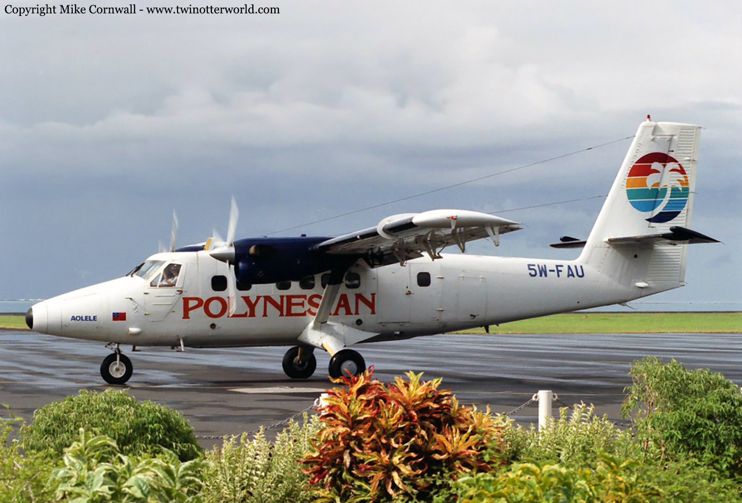
Crash of a De Havilland DHC-6 Twin Otter 300 in Apia: 3 killed

Date & Time: Jan 7, 1997 at 1038 LT
Operator:
Registration:
5W-FAU
Survivors:
Yes
Site:
Schedule:
Pago Pago - Apia
MSN:
678
YOM:
1980
Flight number:
PH211
Region:
Crew on board:
2
Crew fatalities:
Pax on board:
3
Pax fatalities:
Other fatalities:
Total fatalities:
3
Circumstances:
At about 1038 hours on Tuesday 7 January 1997, Polynesian Airlines’ DHC-6 (Twin Otter) 5W FAU collided with the western slopes of Mt Vaea, Apia, in conditions of low cloud and heavy rain. The aeroplane was on a scheduled flight from Pago Pago to Fagali’i, and was being flown to Fagali’i by visual reference after having made an instrument approach to Faleolo. The captain and two passengers lost their lives in the accident. The first officer and one passenger survived.
Probable cause:
The following causal factors were identified:
• The decision by the captain to continue the flight toward Fagali’i in reduced visibility and subsequently in cloud.
• Mis-identification of ground features, or an inappropriate heading and altitude flown, as a result of inadequate visual reference.
• Insufficient forward visibility to ensure effective and timely action to avoid a collision with terrain.

Crash of a Swearingen SA227AC Metro III in Bullhead City

Date & Time: Jan 5, 1997 at 1243 LT
Type of aircraft:
Registration:
N165SW
Survivors:
Yes
Schedule:
Long Beach - Grand Canyon
MSN:
AC-514
YOM:
1982
Crew on board:
2
Crew fatalities:
Pax on board:
19
Pax fatalities:
Other fatalities:
Total fatalities:
0
Captain / Total flying hours:
3200
Captain / Total hours on type:
300.00
Copilot / Total flying hours:
640
Copilot / Total hours on type:
56
Aircraft flight hours:
25111
Circumstances:
After executing a missed approach at the Grand Canyon Airport, the pilots diverted to the Bullhead City Airport. The pilots reported that minimal icing conditions were encountered with about 1/8 inch of ice accumulating on the aircraft wings. The pilots stated they cycled the deice boots to shed ice. They did not observe ice on the propeller spinners, and they did not activate the engines' 'override' ignition systems, as required by the airplane's flight manual. Use of 'override' ignition was required for flight into visible moisture at or below +5 degrees Celsius (+41 degrees Fahrenheit) to prevent ice ingestion/flameouts. Subsequently, both engines flamed out as the airplane was on about a 3 mile final approach for landing with the landing gear and flaps extended. The aircraft was destroyed during an off-airport landing.
Probable cause:
Failure of the pilot(s) to use 'override' ignition as prescribed by checklist procedures during an encounter with icing conditions, which subsequently led to ice ingestion and dual engine flame-outs. Factors related to the accident were: the adverse weather (icing) conditions, the accumulation of airframe/engine ice, and lack of suitable terrain in the emergency landing area.
Final Report:

Crash of a Short 330-300 in Liverpool

Date & Time: Jan 3, 1997 at 0042 LT
Type of aircraft:
Operator:
Registration:
G-ZAPC
Flight Type:
Survivors:
Yes
Schedule:
Exeter - East Midlands
MSN:
3023
YOM:
1978
Region:
Crew on board:
2
Crew fatalities:
Pax on board:
1
Pax fatalities:
Other fatalities:
Total fatalities:
0
Captain / Total flying hours:
3015
Captain / Total hours on type:
900.00
Circumstances:
The aircraft departed Exeter at 2237 hrs where the weather was fair with scattered cloud at 1500 feet. After climbing uneventfully through cloud to FL 90 the aircraft cruisedin clear, smooth air. In the cruise the co-pilot noticed that his vertical speed indicator was displaying a slight rate of climb although the aircraft was in level flight but this and a spurious hydraulic warning were the only anomalies. As the aircraft approached East Midlands airport the runway visual range there was below the approach minima and several aircraft were holding awaiting an improvement in the visibility. G-ZAPC descended to 2,500 ft and held in clear air over the Lichfield NDB for about 45 minutes until the fuel state dictated a diversion to Liverpool. On diversion the aircraft was initially cleared direct to the Whitegate NDB and then Wallasey VOR at FL 40. At this level the crew could see ground features in good visibility until they entered cloudas they descended through 3,500 feet whilst being radar vectored for an approach to Liverpool Airport. The cloud was stratiform in character and did not appear to contain precipitation or significant turbulence. At Liverpool airport the cloud base was 6/8at 1,100 feet, the visibility 12 km, the air temperature +1°Cand the surface wind was 060°/8 kt. There is an ILS localiser on Runway 09 but no glidepath transmitter so a LOC DME approach is normally flown. Although the DME antenna is mid-way along the runway, the DMErange is set to read zero at the runway displaced threshold. The pilot flies the localiser in azimuth and adjusts his height according to his pressure altimeter; the 3° glidepath commences at 1,610 feet QNH from 5 nm DME with check heights at 4, 3, 2 and 1 nm DME. On the north side of the runway 329 metres from the threshold there are 4 PAPI (Precision Approach Path Indicator)lights which are set to a glidepath of 3°. During the approach to Runway 09 at Liverpool all the anti-icing services were switched on and operating except for the wing de-icing boots which, having seen no ice on the wings,the commander decided not to employ, and the ice detector which he considered unreliable. The approach proceeded normally andthe aircraft descended out of cloud at about 1,100 feet having been in cloud for about 10 minutes. When the commander viewed the PAPIs at 1 DME"all four lights had a pink tinge". Thinking he might be slightly low relative to the approach glidepath, he asked the co-pilot to specify the correct height at 1 DME which was 410feet. At the time the commander's pressure altimeter, which was set to the QNH of 1019 mb, indicated that the aircraft was slightly high and so he made a small correction to the flight path which resulted in three red PAPI lights and one white light. The commander also decided to touch down slightly beyond the runway identifier numbers which are a few metres beyond the 'piano keys' that identify the threshold. The aircraft was cleared to land with a wind of "Easterly at 10 kt" and on short finals the commander asked for full flap. He then allowed the speed to bleed back from the approach speed of between 110 and 120 KIAS towards the threshold speed of 90 KIAS without moving the throttles from their approach power setting. According to both crew members and the passenger who was seated in the 'jump seat', the aircraft crossed over the end of runway at between 88 and 90 KIAS. Some 20 to 30 feet above the runway the commander noticed that the flight controls felt 'sloppy' as if the aircraft's speed was unusually low but there was no hint of a stall warning or stick shaker activation. At much the same time all three persons on board felt the aircraft sink rapidly; the commander pulled back on the control column but he was unable to arrest the high rate of descent and the aircraft struck the runway very hard. The right wing dropped as the right main gear collapsed and the aircraft veered to the right off the runway onto the grass. The ground was frozen hard and the aircraft came to a halt without incurring further significant damage. The crew informed ATC that they were unhurt before securing the aircraft whilst ATC activated the airport's emergency services. On leaving the aircraft the commander inspected the wings for ice accretion. He noticed a thin layer of clear,watery ice along the leading edges across the pneumatic de-icing boots from top to bottom. The ice layer could be wiped off with one finger and was no more than one eight of an inch thick. Throughout the flight there had been no visible signs of ice accretion on the wings or the windscreen wiper. Consequently, the commander had not increased the threshold speed to compensate for ice accretion.
Probable cause:
From the available evidence it appears probable that the aircraft developed a high rate of descent from a height of 20 to 30 feet above the runway without producing a stall warning. The following causal factors were considered: wind shear; wake turbulence; pitot-static system errors; low airspeed during the final stages of the approach; and significant ice accretion on the airframe. Wind shear was discounted because numerous wind readings showed the normal slight variation in direction but a consistent wind speed, and there were no obstacles such as hangars upwind of the threshold. Wake turbulence was discounted because the preceding aircraft had landed 19 minutes before GZAPC. The pitot-static systems were checked to be leak free and all relevant instruments were shown to be accurate. It was also established that all pitot head, static plate and stall warning heaters were serviceable. A favourable comparison of the approach profile with those of the preceding four aircraft indicated that there was no evidence of static pressure errors. The calculated airspeeds from radar were consistent with thespeeds reported by the crew for the initial approach suggesting that itot errors were not significant. Thus, unless icing, for example, had affected these systems at a late stage of the approach,erroneous instrument readings were considered unlikely. The final approach was flown at about the correct airspeed but there was a trend within the radar data,for the last mile of the approach, for the airspeed to reduce towards the stalling speed. However the data was too coarse to provide exact speeds and the stall warning system did not activate. The likelihood of significant airframe icing was discounted for several reasons including: the commander's statement; photographs taken of the aircraft shortly after the accident which showed no signs of significant ice accretion; no lumps of ice were found on the runway; and the airframe was icefree when examined by the AAIB despite overnight sub-zero temperatures. There was, therefore, no positive conclusion as to the cause and it remains a possibility that some or all of the above factors, to a small extent, may have combined to produce a high rate of descent while the aircraft was some 20to 30 feet above the runway.
Final Report:

Crash of a Cessna 208B Grand Caravan in Edenton: 2 killed

Date & Time: Jan 2, 1997 at 1835 LT
Type of aircraft:
Operator:
Registration:
N802TH
Flight Type:
Survivors:
No
Schedule:
Manteo - Edenton
MSN:
208B-0179
YOM:
1989
Crew on board:
2
Crew fatalities:
Pax on board:
0
Pax fatalities:
Other fatalities:
Total fatalities:
2
Captain / Total flying hours:
2980
Captain / Total hours on type:
850.00
Aircraft flight hours:
3520
Circumstances:
During his weather briefing, the pilot was told that his destination weather was not available, and was provided weather for an airport about 10 miles north. He was briefed that low visibility due to fog prevailed. The flight departed earlier then usual because the company business manager was concerned that the weather at the destination airport was deteriorating, and if the airplane was not there earlier they might not get into the airport. At the time of the accident there was a power failure, and lights around the destination airport went out. The airplane had struck power lines and a support tower located on the approach end of runway 1 and runway 5, about 1/2 mile southwest of the airport. The airport had one NDB approach which was not authorized at night. The nearest recorded weather, about 10 miles north of the crash site, at the time of the accident was; '...ceiling 100, [visibility] 1/2 mile, fog, [temperature] 46 degrees F, dew point, 42 degrees F, winds 220 degrees at 5 [knots], altimeter 29.90 inches Hg. Witnesses reported that there was heavy fog at the airport and the visibility was below 1/4 mile.
Probable cause:
The pilot's continued VFR flight into instrument meteorological conditions. Factors in this accident were: fog, the low ceiling, and the dark night.
Final Report:

Crash of a Beechcraft C90 King Air in Rhinelander

Date & Time: Dec 28, 1996 at 1145 LT
Type of aircraft:
Registration:
N998VB
Flight Type:
Survivors:
Yes
Schedule:
Moline - Rhinelander
MSN:
LJ-785
YOM:
1978
Crew on board:
1
Crew fatalities:
Pax on board:
9
Pax fatalities:
Other fatalities:
Total fatalities:
0
Captain / Total flying hours:
932
Captain / Total hours on type:
338.00
Aircraft flight hours:
6301
Circumstances:
There were five recorded transmissions of conversations from one of the pilots aboard the accident airplane and the Fort Dodge, Iowa AFSS; one on 12/27 and four on 12/28. The weather forecast for icing included wording such as '...moderate to isolated severe icing from seven thousand downward for your entire route of flight....' The pilot stated that he received 'Full Flight Service briefings...' and also indicated that he spoke to flight watch prior to takeoff. While executing the ILS approach to the destination airport, the pilot was unable to maintain the proper glidepath even with the application of full power. The pilot maintained marginal control of the airplane during the descent until impact with trees and the terrain about 10 miles west of the destination airport. The pilot and passengers reported 'vibration' and 'shudder' of the airplane prior to the impact. One passenger reported that she saw ice forming on the left 'rear' wings. Persons on the ground reported severe icing conditions around the time of the accident.
Probable cause:
the pilot-in-command's inadequate weather evaluation and continued flight into forecast severe icing conditions which exceeded the capabilIty of the airplane's anti-ice/deice system. The icing conditions were a factor.
Final Report:

Crash of a Learjet 35A in Lebanon: 2 killed

Date & Time: Dec 24, 1996 at 1005 LT
Type of aircraft:
Registration:
N388LS
Flight Type:
Survivors:
No
Site:
Schedule:
Bridgeport - Lebanon
MSN:
35-388
YOM:
1981
Crew on board:
2
Crew fatalities:
Pax on board:
0
Pax fatalities:
Other fatalities:
Total fatalities:
2
Captain / Total flying hours:
4250
Captain / Total hours on type:
1000.00
Aircraft flight hours:
6897
Circumstances:
The first officer was in the left seat, flying the airplane, and the captain was in the right seat, for the positioning flight. Approaching the destination, the crew briefed, then attempted an ILS RWY 18 approach. The captain reported not receiving the localizer, when, in fact, the airplane was actually about 5 nautical miles to the left of it. Winds at the airport, about that time, were from 190 degrees true, at 5 knots; however, area winds at 6,000 feet were from 220 degrees, in excess of 40 knots. The crew executed a missed approach, but did not follow the missed approach procedures. The captain later requested, and received clearance for, the VOR RWY 25 approach. The captain partially briefed the approach to the first officer as the airplane neared the VOR, then subsequently "talked through" remaining phases of the approach as they occurred. The outbound course for the VOR RWY 25 approach was 066 degrees, and the minimum altitude outbound was 4,300 feet. After passing the VOR, the captain directed the first officer to maintain 4,700 feet. The airplane's last radar contact occurred as the airplane was proceeding outbound, 7 nautical miles northeast of the VOR, at 4,800 feet. As the airplane approached the course reversal portion of the procedure turn, the captain initially directed the first officer to turn the airplane in the wrong direction. When the proper heading was finally given, the airplane had been outbound for about 2 minutes. During the outbound portion of the course reversal, the captain told the first officer to descend the airplane to 2,900 feet, although the procedure called for the airplane to maintain a minimum of 4,300 feet until joining the inbound course to the VOR. During the inbound portion of the course reversal, the captain amended the altitude to 3,000 feet. As the airplane neared the inbound course to the VOR, the captain called out the outer marker. The first officer agreed, and the captain stated that they could descend to 2,300 feet. The first officer then noted that the VOR indications were fluctuating. The captain pointed out the VOR's continued reception, and the first officer noted, "but it's all over the place." Shortly thereafter, the first officer stated that he was descending the airplane to 2,300 feet. Three seconds later, the airplane impacted trees, then terrain. The wreckage was located at the 2,300-foot level, on rising mountainous terrain, 061 degrees magnetic, 12.5 nautical miles from the VOR. It was also 10.3 nautical miles prior to where a descent to 2,300 feet was authorized. There was no evidence that the crew used available DME information. There was also no evidence of pre-impact mechanical malfunction.
Probable cause:
The captain's failure to maintain situational awareness, which resulted in the airplane being outside the confines of the instrument approach; and the crew's misinterpretation of a stepdown fix passage, which resulted in an early descent into rising terrain. Factors included the captain's misreading of the instrument approach procedure, the crew's rushed and incomplete instrument approach briefing, their failure to use additional, available navigational aids, and their failure to account for the winds at altitude.
Final Report:

Crash of an Antonov AN-72 in Nagurskoye

Date & Time: Dec 23, 1996 at 1200 LT
Type of aircraft:
Flight Type:
Survivors:
Yes
Schedule:
Vorkouta – Nagurskoye
Country:
Region:
Crew on board:
6
Crew fatalities:
Pax on board:
18
Pax fatalities:
Other fatalities:
Total fatalities:
0
Circumstances:
The approach to Nagurskoye Airport was completed by a polar night and in poor weather conditions with snow falls. After landing on an iced and snow covered runway, the aircraft overran, lost its undercarriage and came to rest. Nine occupants were injured, among them four seriously. The aircraft was damaged beyond repair.

Crash of an Antonov AN-32B in Medellín: 4 killed

Date & Time: Dec 21, 1996 at 2232 LT
Type of aircraft:
Operator:
Registration:
HK-4008X
Flight Type:
Survivors:
No
Schedule:
Bogotá – Medellín
MSN:
3402
YOM:
1993
Country:
Crew on board:
3
Crew fatalities:
Pax on board:
1
Pax fatalities:
Other fatalities:
Total fatalities:
4
Captain / Total flying hours:
8635
Captain / Total hours on type:
550.00
Copilot / Total flying hours:
1409
Copilot / Total hours on type:
90
Aircraft flight hours:
403
Circumstances:
The aircraft was completing a cargo flight from Bogotá to Medellín, carrying one passenger, three crew members and a load of 18,300 newspapers for a total weight of 4,970 kilos. While descending to Medellín-Rionegro Airport, the crew encountered difficulties to intercept the ILS and made successives left and right turn when, on final approach, the aircraft went out of control and crashed 8 km short of runway 36. All four occupants were killed.
Probable cause:
Loss of control following the in-flight fracture of the right wing that induced the rupture of the left stabilizer exceeding the ultimate resistance of the structure. The exact cause of the structural failure could not be determined.
Final Report:

Crash of a Douglas DC-8-55F in Port Harcourt

Date & Time: Dec 17, 1996 at 0500 LT
Type of aircraft:
Operator:
Registration:
9G-MKD
Flight Type:
Survivors:
Yes
Schedule:
Luxembourg - Port Harcourt
MSN:
45965
YOM:
1968
Country:
Region:
Crew on board:
4
Crew fatalities:
Pax on board:
0
Pax fatalities:
Other fatalities:
Total fatalities:
0
Circumstances:
While descending to Port Harcourt Airport, the pilot-in-command established a visual contact with the runway lights at an altitude of 2,500 feet. The approach was continued when few seconds later, while the crew was thinking his altitude was 390 feet, the aircraft collided with trees. The captain decided to initiate a go-around procedure but all four engines failed to respond properly. The aircraft continued to descend and struck the ground 250 metres short of runway threshold. Upon impact, the undercarriage were torn off and the aircraft slid for few dozen metres before coming to rest. All four crew members escaped uninjured and the aircraft was damaged beyond repair. It was reported that the aircraft was unstable on final approach.

Crash of a Cessna 425 Conquest in Ronkonkoma: 3 killed

Date & Time: Dec 16, 1996 at 1840 LT
Type of aircraft:
Registration:
N425EW
Survivors:
No
Schedule:
Macon – Ronkonkoma
MSN:
425-0150
YOM:
1983
Crew on board:
1
Crew fatalities:
Pax on board:
2
Pax fatalities:
Other fatalities:
Total fatalities:
3
Captain / Total flying hours:
10846
Captain / Total hours on type:
2089.00
Circumstances:
The pilot had received clearance for the ILS Runway 6 approach and was advised that the previous landing traffic reported '...breaking out at minimums.' Radar data revealed that the airplane descended in instrument meteorological conditions to the decision height altitude of 294 feet, approximately 3 miles from the missed approach point. The pilot did not perform the missed approach procedure. The airplane leveled off and continued at or below decision height altitude for approximately 28 seconds, traveling a distance of approximately 1 mile. Four low altitude alerts appeared on the tower controller's display. The controller stated he withheld the alert because '...it was a critical phase of flight and the aircraft appeared to be climbing...' The airplane collided with trees and terrain approximately 1.5 miles from the approach end of the landing runway.
Probable cause:
The pilot's early descent to decision height and his failure to perform the missed approach procedure. A factor was the failure of air traffic control to issue a safety advisory.
Final Report: