Crash of a Fairchild-Hiller FH-227B in Keflavik

Date & Time: Jul 26, 1998 at 2355 LT
Type of aircraft:
Operator:
Registration:
N564LE
Flight Type:
Survivors:
Yes
Schedule:
Billund - Aberdeen - Keflavik
MSN:
564
YOM:
1967
Country:
Region:
Crew on board:
2
Crew fatalities:
Pax on board:
0
Pax fatalities:
Other fatalities:
Total fatalities:
0
Circumstances:
On final approach, when the landing gears were extended, the crew heard loud cracking noise. The landing was aborted and the aircraft passed the tower for visual inspection and one of the crew went to the cabin for visual check of the landing gears where he observed that the right landing gear lock strut rear member had broken loose from the side member assembly and was hanging down. Upon touchdown the gear folded up and the aircraft right propeller, wing tip and bottom of the fuselage touched ground and the aircraft went off the runway in a gentle right turn. The fuselage bottom skin and frame structure sustained extensive damage and the right wing tip, propeller blades, lock strut assembly and drag strut were destroyed. The aircraft operated on a ferry flight from Billund, Denmark to Miami-Opa Locka, Florida, with en route stops at among others Aberdeen and Keflavík.
Probable cause:
Preliminary investigation revealed that no lubricant was found in the lock strut hinge pin that should normally be packed with grease.

Crash of a Partenavia P.68B in Wagga Wagga: 2 killed

Date & Time: Jul 20, 1998 at 1739 LT
Type of aircraft:
Registration:
VH-IXH
Flight Type:
Survivors:
No
Schedule:
Corowa – Albury – Wagga Wagga
MSN:
186
YOM:
1979
Country:
Region:
Crew on board:
1
Crew fatalities:
Pax on board:
1
Pax fatalities:
Other fatalities:
Total fatalities:
2
Captain / Total flying hours:
1014
Captain / Total hours on type:
217.00
Circumstances:
The aircraft operator had been contracted to provide a regular service transporting bank documents, medical pathology samples and items of general freight between Wagga Wagga, Albury and Corowa. On the day of the accident a passenger was accompanying the pilot for the day's flying. The pilot commenced the flight from Corowa to Albury under the Visual Flight Rules, flying approximately 500 ft above ground level. At Albury he obtained the latest aerodrome weather report for Wagga Wagga, which indicated that there was scattered cloud at 300 ft above ground level, broken cloud at 600 ft above ground level, visibility restricted to 2,000 m in light rain and a sea-level barometric pressure (QNH) of 1008 hPa. At 1715 Eastern Standard Time (EST) the aircraft departed Albury for Wagga Wagga under the Instrument Flight Rules. The pilot contacted the Melbourne en-route controller at 1728 and reported that he was maintaining 5,000 ft. Although the aircraft was operating outside controlled airspace, the en-route controller did have a radar surveillance capability and was providing the pilot with a flight information service. However, no return was recorded from the aircraft's transponder and at 1732 the pilot reported that he was transferring to the Wagga Wagga Mandatory Broadcast Zone frequency. This was the pilot's last contact with the controller. Although air traffic services do not monitor or record the Wagga Wagga Mandatory Broadcast Zone frequency, transmissions made on this frequency are recorded by AVDATA for the purpose of calculating aircraft landing charges. This information was reviewed following the accident. The pilot broadcast his position inbound to the aerodrome on the mandatory broadcast zone frequency and indicated that he was conducting a Global Positioning System (GPS) arrival. He established communication with the pilot of another inbound aircraft and at 9 NM from the aerodrome, broadcast his position as he descended through 2,900 ft. Approximately 1 minute and 20 seconds later, the pilot advised that he was passing 2,000 ft but immediately corrected this to state that he was maintaining 2,000 ft. He also stated that it was "getting pretty gloomy" and that according to the latest weather report he should be visual at the procedure's minimum descent altitude. The aircraft would have been approximately 6 NM from the aerodrome at this time. This was the last transmission heard from the pilot. The resident of a house to the south of Gregadoo Hill sighted the aircraft a short time before the accident. He was standing outside his house and stated that the aircraft was visible as it passed directly overhead at what appeared to be an unusually low height. The aircraft then disappeared into cloud that was obscuring Gregadoo Hill, approximately 350 m from where he was standing. Moments later he heard the sound of an impact followed almost immediately by a red flash of light. The noise from the engines appeared to be normal up until the sound of the impact. The aircraft had collided with steeply rising terrain on the southern face of Gregadoo Hill, approximately 40 ft below the crest. The hill is 4 NM from the aerodrome and is marked on instrument approach charts as a spot height elevation of 1,281 ft. The estimated time of the accident was 1739. The pilot and passenger sustained fatal injuries.
Probable cause:
The pilot had received an accurate appreciation of the weather conditions in the vicinity of Wagga Wagga prior to departing Albury. At that stage it would have been apparent that low cloud and poor visibility were likely to affect the aircraft's arrival. Under such conditions it would not have been possible to land from the GPS arrival procedure. As the reported cloud base and visibility were both below the minimum criteria, it is difficult to rationalise the pilot's transmission that, according to the latest weather report, he would be visual at the minimum descent altitude. This statement suggests that the pilot had already made the decision to continue his descent below the minimum altitude for the procedure and to attempt to establish visual reference for landing. Based on the report of broken low cloud in the vicinity of the aerodrome, the pilot would have needed to descend to 1,324 ft above mean sea level to establish the aircraft clear of cloud. This is within 50 ft of the last altitude recorded on the GPS receiver. Due to the difference between the actual and forecast QNH, the left altimeter would over-read by approximately 150 ft. At the time of the occurrence an otherwise correctly functioning instrument would have indicated an altitude of approximately 1,400 ft. The pilot had probably set the right altimeter to the local QNH prior to departing Albury. As this setting also corresponded to the actual QNH at Wagga Wagga, that instrument would have provided the more accurate indication of the aircraft's operating altitude. However, because of its location on the co-pilot's instrument panel, it is unlikely that the pilot would have included that altimeter in his basic instrument scan. It was not possible to assess the extent to which illicit drugs may have influenced the pilot's performance during the flight and affected his ability to safely operate the aircraft.
The following factors were identified:
- The pilot was operating the aircraft in instrument meteorological conditions below the approved minimum descent altitude.
- Low cloud was covering Gregadoo Hill at the time of the accident.
Final Report:

Crash of a Boeing 737-2J8C in Khartoum

Date & Time: Jul 19, 1998 at 1105 LT
Type of aircraft:
Operator:
Registration:
ST-AFL
Survivors:
Yes
Schedule:
Khartoum - Dongola
MSN:
21170
YOM:
1975
Flight number:
SD122
Country:
Region:
Crew on board:
9
Crew fatalities:
Pax on board:
91
Pax fatalities:
Other fatalities:
Total fatalities:
0
Circumstances:
Shortly after takeoff from Khartoum-Haj Yussuf Airport, while climbing, the captain reported hydraulic problems and was cleared by ATC for an immediate return. After touchdown, several tires burst and the crew thought it was an engine malfunction so he deactivated the thrust reverser systems. Unable to stop within the remaining distance, the aircraft overran and collided with construction machines before coming to rest near a telecommunication relay. All 100 occupants evacuated safely while the aircraft was damaged beyond repair.

Crash of an Ilyushin II-78 in Asmara: 10 killed

Date & Time: Jul 17, 1998 at 0415 LT
Type of aircraft:
Operator:
Registration:
UR-UCI
Flight Type:
Survivors:
No
Schedule:
Burgas - Asmara
MSN:
0834 14444
YOM:
1978
Flight number:
UKS701
Location:
Country:
Region:
Crew on board:
9
Crew fatalities:
Pax on board:
1
Pax fatalities:
Other fatalities:
Total fatalities:
10
Circumstances:
Following an uneventful cargo flight from Burgas, the crew started a night approach to Asmara-Yohannes IV Airport. The visibility was relatively limited due to local patches of fog on approach. On final, at an altitude of 2,405 metres, the aircraft struck the slope of a mountain located 4,3 km short of runway 25. The aircraft disintegrated on impact and all 10 occupants were killed. The wreckage was found 72 metres below the summit. Remains still present at N15.304268 E38.959811 by December 2012.
Probable cause:
The following findings were identified:
- The crew decided to perform a visual approach to runway 25 while an instrument approach to runway 07 was the normal procedure,
- Limited visibility due to marginal weather conditions,
- ATC cleared the crew for an approach to runway 25 which was non-compliant according to published procedures,
- The crew failed to initiate a go-around procedure,
- The total weight of the aircraft at takeoff from Burgas Airport was at least 37 tons above MTOW and the crew was probably not aware of this situation.

Crash of a Rockwell Sabreliner 60 in Córdoba: 3 killed

Date & Time: Jul 16, 1998 at 2140 LT
Type of aircraft:
Operator:
Registration:
LV-WPO
Flight Type:
Survivors:
No
Schedule:
Salta – San Miguel de Tucumán – Córdoba
MSN:
306-3
YOM:
1967
Country:
Crew on board:
2
Crew fatalities:
Pax on board:
1
Pax fatalities:
Other fatalities:
Total fatalities:
3
Captain / Total flying hours:
2082
Copilot / Total flying hours:
3084
Aircraft flight hours:
8587
Circumstances:
The aircraft was completing a cargo service from Salta to Córdoba with an intermediate stop in San Miguel de Tucumán, carrying one passenger and two pilots. En route to Córdoba, the crew was cleared to descend to an altitude of 8,000 feet and later for an ILS approach to runway 18. By night and IMC conditions, the aircraft descended below the MDA when it crashed in an open field located 11,4 km short of runway. The aircraft was destroyed and all three occupants were killed.
Probable cause:
By night and IMC conditions, the crew was unable to intercept the ILS for runway 18 and continued the descent below MDA until impact with the ground.
Final Report:

Crash of a Cessna T303 Crusader near Nottingham

Date & Time: Jul 16, 1998 at 1833 LT
Type of aircraft:
Registration:
G-BSPF
Flight Type:
Survivors:
Yes
Schedule:
Sheffield – Nottingham
MSN:
303-00100
YOM:
1982
Region:
Crew on board:
1
Crew fatalities:
Pax on board:
0
Pax fatalities:
Other fatalities:
Total fatalities:
0
Captain / Total flying hours:
290
Captain / Total hours on type:
68.00
Circumstances:
The aircraft was en route from Sheffield City Airport to Nottingham where it was based. The pilot joined the traffic zone at Burton Joyce, an unofficial but well used Visual Reporting Point, at a height of about 1,000 feet. The weather was fine with good visibility and the pilot took the opportunity to view the house of the aircraft's co-owner located in the vicinity of Burton Joyce. While orbiting the house, the pilot felt a moderate 'bumping' sensation which he attributed to thermal activity rather than pre-stall buffet. The left wing suddenly dropped and the aircraft rolled through the vertical. The pilot applied corrective rudder and moved the control column forward which rolled the aircraft erect but he was unable to arrest the rate of descent because the engines did not appear to be developing full power. He therefore elected to carry out a forced landing with the landing gear retracted. On approaching the field, the aircraft struck a telegraph pole, yawed to the left and landed with a very high rate of descent before coming to a halt after a short ground slide. The pilot was unable to evacuate the aircraft because of his injuries but was rescued by local people who were quickly on the scene. There was no fire. The pilot stated that at the time the aircraft departed from normal flight, he was flying at about 100 kt with 60° of bank. The basic stalling speed of the aircraft in the configuration at the time was about 70 kt. Application of the correction for load factor in the turn would have given a stalling speed of 100 kt. The majority of eye witnesses stated that the aircraft was very low at the point at which it departed from normal flight, probably in the region of 300 feet above ground level.
Final Report:

Crash of a Swearingen SA26T Merlin IIB in Saint George: 2 killed

Date & Time: Jul 7, 1998 at 1547 LT
Type of aircraft:
Operator:
Registration:
N501FS
Flight Type:
Survivors:
No
Site:
Schedule:
Anchorage - Saint George
MSN:
T26-146
YOM:
1969
Crew on board:
2
Crew fatalities:
Pax on board:
0
Pax fatalities:
Other fatalities:
Total fatalities:
2
Captain / Total flying hours:
13000
Captain / Total hours on type:
250.00
Aircraft flight hours:
7799
Circumstances:
The flight departed Anchorage, Alaska, and was en route to Saint George, Alaska, to pick up passengers for a return flight to Anchorage. The pilot-in-command (PIC) was seated in the right seat, and the copilot was seated in the left seat. This was the copilot's third flight in this make and model airplane, and he was not qualified as a crewman in it under 14 CFR Part 135. There was no record of when the copilot last performed a non directional beacon (NDB) approach. The NDB indicator in the cockpit was on the left side of the left control column, partially blocked from the view of the PIC. The minimum altitude for the segment of the approach prior to the final approach fix (FAF) was 1,700 feet. The Minimum Descent Altitude (MDA) for the final segment of the approach was 880 feet. The reported ceiling was 100 feet overcast. The Air Route Traffic Control Center radar altitude readout for the airplane revealed that the airplane descended below 600 feet prior to reaching the FAF. The radar ground track revealed the airplane on course prior to the course reversal procedure turn on the published approach. The radar ground track showed that after the course reversal, the airplane continued through the published final approach course, and turned to parallel the inbound track three miles north of course. The radar plot terminates about the location of the 550 feet high cliffs where the airplane was located. Weather at the time of the accident was reported as 100 foot overcast. This location was 5.5 miles (DME) from the airport. A review of radar tapes from the day prior to the accident, show the same airplane and PIC tracking the published course outbound and inbound, and descending below the published approach minima to below 500 feet. This flight successfully landed at the airport. An interview with the copilot from the successful flight revealed that the PIC intentionally descended to 300 feet on the approach until he acquired visual contact with the ocean, then flew to the airport to land. An aircraft flying on the published inbound final approach course at 5.5 DME is over water, approximately three miles from the nearest terrain.
Probable cause:
The pilot-in-command's failure to adequately monitor the instrument approach and the copilot's failure to intercept and maintain the proper NDB bearing on the approach. Contributing factors were the pilot-in-command's obstructed view of the NDB indicator and his overconfidence in his personal ability, the terrain (cliffs), low ceiling, and the flight crew's disregard of the minimum descent altitude.
Final Report:

Crash of a Let L-410UVP-E in Dhaka

Date & Time: Jun 27, 1998
Type of aircraft:
Operator:
Registration:
S2-ADD
Survivors:
Yes
Schedule:
Ishwardi - Dhaka
MSN:
91 26 18
YOM:
1991
Country:
Region:
Crew on board:
5
Crew fatalities:
Pax on board:
2
Pax fatalities:
Other fatalities:
Total fatalities:
0
Circumstances:
While approaching Dhaka-Tejgaon Airport at an altitude of 4,000 feet, the crew encountered technical problems with the right engine they shut down. Few seconds later, the crew was able to restart the right engine but as the temperature of the turbine increased, he shut down the engine again. This time, he was unable to feather the propeller. Due to excessive drag, the aircraft lost height and the captain attempted an emergency landing in an open field. On landing, the aircraft lost its undercarriage and came to rest. All seven occupants escaped uninjured while the aircraft was damaged beyond repair.
Probable cause:
Failure of the right engine for unknown reasons. Failure of the automatic propeller pitch control mechanism was a contributing factor.

Crash of a Beechcraft 200 Super King Air near Abidjan: 8 killed

Date & Time: Jun 26, 1998 at 1940 LT
Operator:
Registration:
ZS-MSL
Survivors:
No
Schedule:
Luanda - Lomé - Abidjan
MSN:
BB-815
YOM:
1981
Location:
Country:
Region:
Crew on board:
1
Crew fatalities:
Pax on board:
7
Pax fatalities:
Other fatalities:
Total fatalities:
8
Captain / Total flying hours:
1512
Captain / Total hours on type:
201.00
Circumstances:
The twin engine aircraft was completing a special flight from Luanda to Abidjan with an intermediate stop in Lomé, carrying seven UNO emissaries and one pilot. While descending to Abidjan-Félix Houphouët-Boigny Airport, the pilot encountered very low visibility due to foggy conditions. On approach, the aircraft entered a left turn then an uncontrolled descent and crashed about 30 km from the airport. All eight occupants were killed, among them Alioune Blondin Béye, Malian Minister of Foreign Affairs, aged 59.
Probable cause:
It is believed that the pilot lost control of the aircraft following a spatial disorientation while descending in very low visibility due to foggy conditions. At the time of the accident, wind was from 240 at 7 knots.

Crash of a Swearingen SA226AC Metro II in Montreal: 11 killed

Date & Time: Jun 18, 1998 at 0728 LT
Type of aircraft:
Operator:
Registration:
C-GQAL
Survivors:
No
Schedule:
Montreal - Peterborough
MSN:
TC-233
YOM:
1977
Flight number:
PRO420
Country:
Crew on board:
2
Crew fatalities:
Pax on board:
9
Pax fatalities:
Other fatalities:
Total fatalities:
11
Captain / Total flying hours:
6515
Captain / Total hours on type:
4200.00
Copilot / Total flying hours:
2730
Copilot / Total hours on type:
93
Aircraft flight hours:
28931
Circumstances:
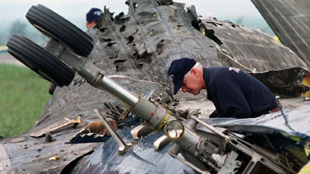
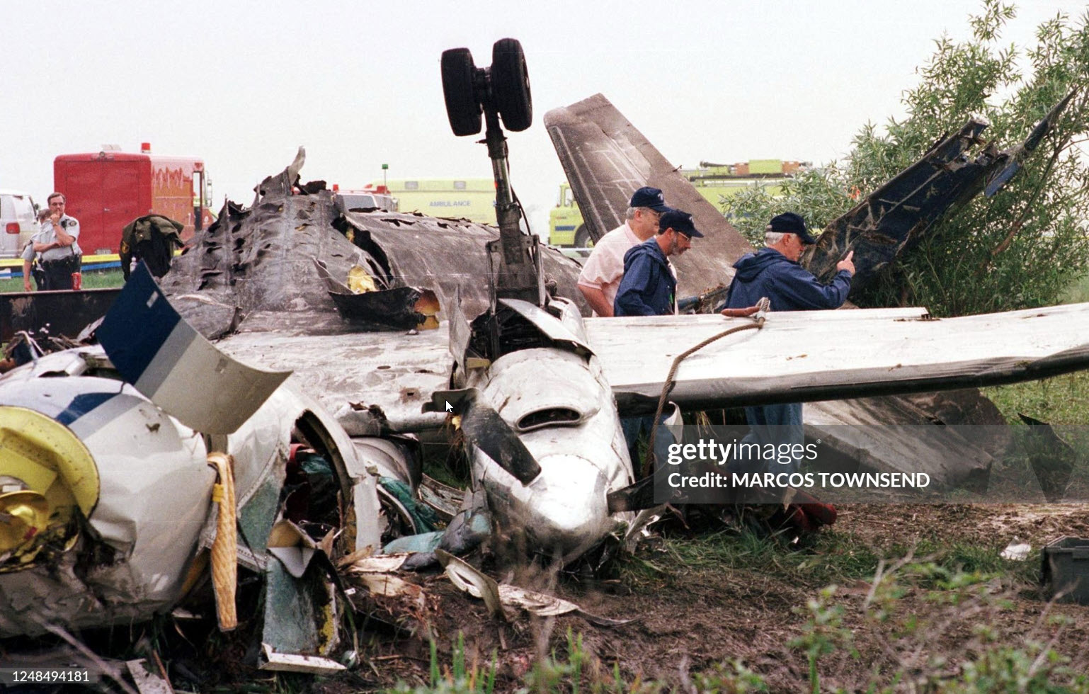
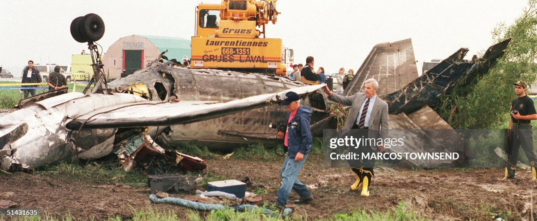
On the morning of 18 June 1998, Propair 420, a Fairchild-Swearingen Metro II (SA226-TC), C-GQAL, took off for an instrument flight rules flight from Dorval, Quebec, to Peterborough, Ontario. The aircraft took off from Runway 24 left (L) at 0701 eastern daylight time. During the ground acceleration phase, the aircraft was pulling to the left of the runway centreline, and the right rudder was required to maintain take-off alignment. Two minutes later, Propair 420 was cleared to climb to 16 000 feet above sea level (asl). At 0713, the crew advised the controller of a decrease in hydraulic pressure and requested to return to the departure airport, Dorval. The controller immediately gave clearance for a 180° turn and descent to 8000 feet asl. During this time, the crew indicated that, for the moment, there was no on-board emergency. The aircraft initiated its turn 70 seconds after receiving clearance. At 0713:36, something was wrong with the controls. Shortly afterward came the first perceived indication that engine trouble was developing, and the left wing overheat light illuminated about 40 seconds later. Within 30 seconds, without any apparent checklist activity, the light went out. At 0718:12, the left engine appeared to be on fire, and it was shut down. Less than one minute later, the captain took the controls. The flight controls were not responding normally: abnormal right aileron pressure was required to keep the aircraft on heading. At 0719:19, the crew advised air traffic control (ATC) that the left engine was shut down, and, in response to a second suggestion from ATC, the crew agreed to proceed to Mirabel instead of Dorval. Less than a minute and a half later, the crew informed ATC that flames were coming out of the 'engine nozzle'. Preparations were made for an emergency landing, and the emergency procedure for manually extending the landing gear was reviewed. At 0723:10, the crew informed ATC that the left engine was no longer on fire, but three and a half minutes later, they advised ATC that the fire had started again. During this time, the aircraft was getting harder to control in roll, and the aileron trim was set at the maximum. Around 0727, when the aircraft was on short final for Runway 24L, the landing gear lever was selected, but only two gear down indicator lights came on. Near the runway threshold, the left wing failed upwards. The aircraft then rotated more than 90° to the left around its longitudinal axis and crashed, inverted, on the runway. The aircraft immediately caught fire, slid 2500 feet, and came to rest on the left side the runway. When the aircraft crashed, firefighters were near the runway threshold and responded promptly. The fire was quickly brought under control, but all occupants were fatally injured.
Probable cause:
Findings as to Causes and Contributing Factors:
- The crew did not realize that the pull to the left and the extended take-off run were due to the left brakes' dragging, which led to overheating of the brake components.
- Dragging of the left brakes was most probably caused by an unidentified pressure locking factor upstream of the brakes on take-off. The dragging caused overheating and leakage, probably at one of the piston seals that retain the brake hydraulic fluid.
- When hydraulic fluid leaked onto the hot brake components, the fluid caught fire and initiated an intense fire in the left nacelle, leading to failure of the main hydraulic system.
- When the L WING OVHT light went out, the overheating problem appeared corrected; however, the fire continued to burn.
- The crew never realized that all of the problems were associated with a fire in the wheel well, and they did not realize how serious the situation was.
- The left wing was weakened by the wing/engine fire and failed, rendering the aircraft uncontrollable.
Findings as to Risk:
- Numerous previous instances of brake overheating or fire on SA226 and SA227 aircraft had the potential for equally tragic consequences. Not all crews flying this type of aircraft are aware of its history of numerous brake overheating or fire problems.
- The aircraft flight manual and the emergency procedures checklist provide no information on the possibility of brake overheating, precautions to prevent brake overheating, the symptoms that could indicate brake problems, or actions to take if overheated brakes are suspected.
- More stringent fire-blocking requirements would have retarded combustion of the seats, reducing the fire risk to the aircraft occupants.
- A mixture of the two types of hydraulic fluid lowered the temperature at which the fluid would ignite, that is, below the flashpoint of pure MIL-H-83282 fluid.
- The aircraft maintenance manual indicated that the two hydraulic fluids were compatible but did not mention that mixing them would reduce the fire resistance of the fluid.
Other Findings:
- The master cylinders were not all of the same part number, resulting in complex linkage and master cylinder adjustments, complicated overall brake system functioning, and difficult troubleshooting of the braking system. However, there was no indication that this circumstance caused residual brake pressure.
- The latest recommended master cylinders are required to be used only with specific brake assembly part numbers, thereby simplifying adjustments, functioning, and troubleshooting.
- Although the emergency checklist for overheating in the wing required extending the landing gear, the crew did not do this because the wing overheat light went out before the crew initiated the checklist.
- The effect of the fire in the wheel well made it difficult to move the ailerons, but the exact cause of the difficulty was not determined.
Final Report: