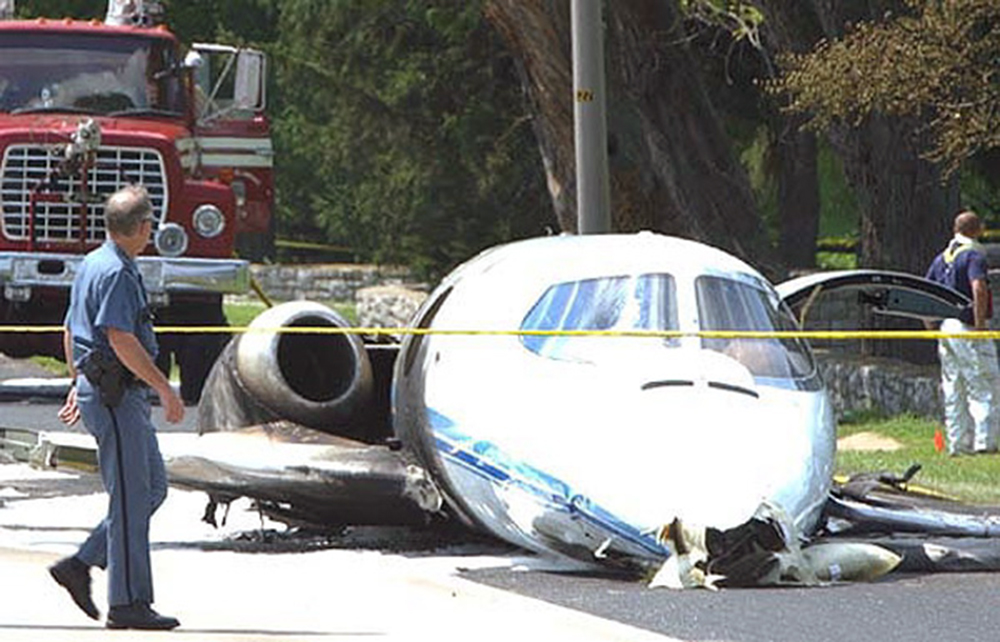
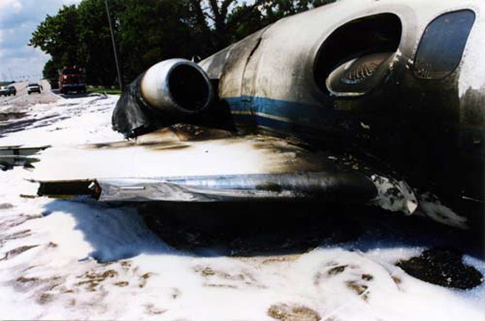
Crash of a Beechcraft B90 King Air in Dodge City: 3 killed

Date & Time: Feb 17, 2004 at 0257 LT
Type of aircraft:
Operator:
Registration:
N777KU
Flight Type:
Survivors:
No
Schedule:
Wichita - Dodge City
MSN:
LJ-377
YOM:
1968
Crew on board:
1
Crew fatalities:
Pax on board:
2
Pax fatalities:
Other fatalities:
Total fatalities:
3
Captain / Total flying hours:
3066
Captain / Total hours on type:
666.00
Aircraft flight hours:
9005
Circumstances:
The emergency medical services (EMS) airplane was destroyed by terrain impact and post impact fire about 7 nautical miles (nm) west of its destination airport, Dodge City Regional Airport (DDC), Dodge City, Kansas. The 14 Code of Federal Regulations Part 91 positioning flight departed the Wichita Mid-Continental Airport (ICT), Wichita, Kansas, about 0215 central standard time and was en route to DDC. Night visual meteorological conditions prevailed when the accident occurred about 0257 central standard time. The flight had been on an instrument flight rules (IFR) flight plan, but the pilot cancelled the IFR flight plan about 34 nm east of DDC and initiated a descent under visual flight rules. Radar track data indicated that the airplane maintained a magnetic course of about 265 degrees during the flight from ICT to DDC. The rate of descent was about 850 to 950 feet per minute. During the descent, the airplane flew past the airport on a 270 degree course. Witnesses in the area reported hearing the engine noise of a low-flying airplane followed by the sound of impact. One of the witnesses described the engine noise as sounding like the engines were at "full throttle." The on-site inspection revealed that the airplane impacted the terrain in a gear-up, wings-level attitude. The inspection of the airplane revealed no anomalies to the airframe or engines. A review of the pilot's 72-hour history before the accident revealed that it had been 14 hours and 32 minutes from the time the pilot reported for duty about 1225 central standard time until the time of the accident. It had been 20 hours 57 minutes from the time the pilot awoke (0600) on the morning before the accident until the time of the accident. No evidence of pilot impairment due to carbon monoxide, drugs, or medical incapacitation was found. The accident occurred during a time of day that was well past the pilot's normal bedtime and also at a time of day when the physiological need to sleep is especially strong. The findings from a Safety Board's human performance analysis indicates that the pilot was likely fatigued. A review of 14 CFR 135.267 indicated that the pilot had adhered to the flight time limitations and rest requirements specified in the regulation.
Probable cause:
The pilot failed to maintain clearance with terrain due to pilot fatigue (lack of sleep).
Final Report:

Crash of a Cessna 414A Chancellor in Laupahoehoe: 3 killed

Date & Time: Jan 31, 2004 at 0140 LT
Type of aircraft:
Operator:
Registration:
N5637C
Flight Phase:
Flight Type:
Survivors:
No
Site:
Schedule:
Honolulu – Hilo
MSN:
414A-0118
YOM:
1978
Crew on board:
1
Crew fatalities:
Pax on board:
2
Pax fatalities:
Other fatalities:
Total fatalities:
3
Captain / Total flying hours:
8230
Captain / Total hours on type:
1037.00
Aircraft flight hours:
11899
Circumstances:
The airplane collided with trees and mountainous terrain at the 3,600-foot-level of Mauna Kea Volcano during an en route cruise descent toward the destination airport that was 21 miles east of the accident site. The flight departed Honolulu VFR at 0032 to pickup a patient in Hilo, on the Island of Hawaii. The inter island cruising altitude was 9,500 feet and the flight was obtaining VFR flight advisories. At 0113, just before the flight crossed the northwestern coast of Hawaii, the controller provided the pilot with the current Hilo weather, which was reporting a visibility of 1 3/4 miles in heavy rain and mist with ceiling 1,700 feet broken, 2,300 overcast. Recorded radar data showed that the flight crossed the coast of Hawaii at 0122, descending through 7,400 feet tracking southeast bound toward the northern slopes of Mauna Kea and Hilo beyond. The last recorded position of the aircraft was about 26 miles northwest of the accident site at a mode C reported altitude of 6,400 feet. At 0130, the controller informed the pilot that radar contact was lost and also said that at the airplane's altitude, radar coverage would not be available inbound to Hilo. The controller terminated radar services. A witness who lived in the immediate area of the accident site reported that around 0130 he heard a low flying airplane coming from the north. He alked outside his residence and observed an airplane fly over about 500 feet above ground level (agl) traveling in the direction of the accident site about 3 miles east. The witness said that light rain was falling and he could see a half moon, which he thought provided fair illumination. The area forecast in effect at the time of the flight's departure called for broken to overcast layers from 1,000 to 2,000 feet, with merging layers to 30,000 feet and isolated cumulonimbus clouds with tops to 40,000 feet. It also indicated that the visibility could temporarily go below 3 statute miles. The debris path extended about 500 feet along a magnetic bearing of 100 degrees with debris scattered both on the ground and in tree branches. Investigators found no anomalies with the airplane or engines that would have precluded normal operation. Pilots for the operator typically departed under VFR, even in night conditions or with expectations of encountering adverse weather, to preclude ground holding delays. The pilots would then pick up their instrument flight rules (IFR) clearance en route. The forecast and actual weather conditions at Hilo were below the minimums specified in the company Operations Manual for VFR operations.
Probable cause:
The pilot's disregard for an in-flight weather advisory, his likely encounter with marginal VFR or IMC weather conditions, his decision to continue flight into those conditions, and failure to maintain an adequate terrain clearance altitude resulting in an in-flight collision with trees and mountainous terrain. A contributing factor was the pilot's failure to adhere to the VFR weather minimum procedures in the company's Operations Manual.
Final Report:

Crash of a Beechcraft A100 King Air in Terrace Bay

Date & Time: Jan 1, 2004
Type of aircraft:
Operator:
Registration:
C-GFKS
Flight Phase:
Flight Type:
Survivors:
Yes
Schedule:
Terrace Bay – Thunder Bay
MSN:
B-247
YOM:
1979
Country:
Crew on board:
2
Crew fatalities:
Pax on board:
0
Pax fatalities:
Other fatalities:
Total fatalities:
0
Circumstances:
On take off roll on runway 25 at dusk, left wing struck a snowbank on left side of the runway. Aircraft veered off runway and came to rest in snow with its nose gear sheared off and several damages to the fuselage. Both pilots were uninjured.
Probable cause:
A NOTAM stated that there were windrows four feet high, 10 feet inside the runway lights on both sides of the runway. This NOTAM also stated that the cleared portion of the runway was covered with ¼ inch of loose snow over 60 percent compacted snow and 40 percent ice patches and that braking action was fair to poor. The take-off was being conducted at dusk in conditions of poor lighting and contrast. Crosswind was not a factor.

Crash of a Learjet 35A in Cancún

Date & Time: Aug 14, 2003 at 2222 LT
Type of aircraft:
Registration:
N403FW
Flight Type:
Survivors:
Yes
Schedule:
Fort Lauderdale - Cancún
MSN:
35-403
YOM:
1981
Country:
Crew on board:
2
Crew fatalities:
Pax on board:
3
Pax fatalities:
Other fatalities:
Total fatalities:
0
Aircraft flight hours:
7950
Circumstances:
On August 14, 2003, about 2222 central daylight time, a Gates LearJet Corporation 35A, N403FW, registered to Aircraft Holdings LLC, operated by Air America Flight Services, Inc., was landed with the landing gear retracted at the Cancun International Airport, Cancun, Mexico. Visual meteorological conditions prevailed at the time and an instrument flight rules flight plan was filed for the 14 CFR Part 91 positioning flight. The airplane was substantially damaged and there were no injuries to the airline transport rated pilot and copilot, nor to the three medical personnel on board the airplane. The flight originated about 2145 eastern daylight time from the Fort Lauderdale Executive Airport, Fort Lauderdale, Florida. According to the director of operations for the operator, the airplane was cleared for a visual approach to runway 12, and the flightcrew advised him they did read the landing checklist. The landing gear was down and locked as indicated by the three green lights; though they didn't recall if the landing gear was extended as evidenced by the landing lights. They also advised him of feeling fuselage to runway surface contact; the airplane slid approximately 4,000 feet before coming to rest upright. Following the occurrence, the nose of the airplane was raised and the nose landing gear was observed to be inside the wheel well. Emergency extension of the landing gear was initiated and the nose landing gear extended and locked; the main landing gear did not extend as fuselage to runway contact prevented extension of the main landing gears. The airplane was dragged from the runway where approximately 2 days later, a crane raised the airplane. At that time, the main landing gears which were in the wheel wells, extended and locked into position.

Crash of a Cessna 208B Grand Caravan near Rooisand: 4 killed

Date & Time: Jun 26, 2003 at 1930 LT
Type of aircraft:
Operator:
Registration:
V5-CAS
Flight Phase:
Flight Type:
Survivors:
No
Site:
Schedule:
Rooisand - Windhoek
MSN:
208B-0549
YOM:
1996
Country:
Region:
Crew on board:
1
Crew fatalities:
Pax on board:
3
Pax fatalities:
Other fatalities:
Total fatalities:
4
Circumstances:
Chartered by International SOS, the single engine aircraft was dispatched to the Rooisand Desert Ranch Aerodrome with a medical team to pick up a patient who suffered a car accident. The aircraft landed at Rooisand Airstrip about 15 minutes before sunset. Due to the night and because the airfield was not equipped with any light systems, the pilot asked people to park their cars along the runway with their lights on. After take off, the aircraft continued westbound with a 12 knots tailwind and was supposed to circle the runway two or three times to gain sufficient height to avoid the hills surrounding the area. Then the aircraft turned right towards a hill that was 258 metres higher than the end of the runway. The aircraft had flown about 4,8 km far towards that hill when it banked steeply to the left and headed back to the southeast. The aircraft then descended to a height of 191 metres until it struck the slope of a hill. The wreckage was found 17 metres below the hill's top and all four occupants were killed.
Probable cause:
Controlled flight into terrain caused by the combination of the following factors:
- The decision of the pilot to take off from an airfield that was not suitable for night operations,
- The absence of a copilot considerably increased the workload of the captain, assuming that the copilot could have assisted him in the reconnaissance of the terrain, the preparation of the flight, the assistance to the patient and the medical team,
- Lack of visibility due to the night and lack of visual reference points on the ground, especially since the pilot had to wear corrective glasses,
- The pilot could not clearly distinguish the various parameters displayed on his instrument's panel because he forgot his glasses.

Crash of a Beechcraft B200C Super King Air in Coffs Harbour

Date & Time: May 15, 2003 at 0833 LT
Operator:
Registration:
VH-AMR
Flight Type:
Survivors:
Yes
Schedule:
Sydney – Coffs Harbour
MSN:
BL-126
YOM:
1985
Country:
Region:
Crew on board:
1
Crew fatalities:
Pax on board:
3
Pax fatalities:
Other fatalities:
Total fatalities:
0
Captain / Total flying hours:
18638
Captain / Total hours on type:
460.00
Circumstances:
The aircraft impacted the sea or a reef about 6 km north-east of Coffs Harbour airport. The impact occurred immediately after the pilot initiated a go-around during an instrument approach to runway 21 in Instrument Meteorological Conditions (IMC) that included heavy rain and restricted visibility. Although the aircraft sustained structural damage and the left main gear detached, the aircraft remained airborne. During the initial go-around climb, the aircraft narrowly missed a breakwater and adjacent restaurant at the Coffs Harbour boat harbour. Shortly after, the pilot noticed that the primary attitude indicator had failed, requiring him to refer to the standby instrument to recover from an inadvertent turn. The pilot positioned the aircraft over the sea and held for about 30 minutes before returning to Coffs Harbour and landing the damaged aircraft on runway 21. There were no injuries or any other damage to property and/or the environment because of the accident. The aircraft was on a routine aeromedical flight from Sydney to Coffs Harbour with the pilot, two flight nurses, and a stretcher patient on board. The flight was conducted under instrument flight rules (IFR) in predominantly instrument meteorological conditions (IMC). During the descent, the enroute air traffic controller advised the pilot to expect the runway 21 Global Positioning System (GPS) non-precision approach (NPA). The pilot reported that he reviewed the approach diagram and planned a 3-degree descent profile. He noted the appropriate altitudes, including the correct minimum descent altitude (MDA) of 580 ft, on a reference card. A copy of the approach diagram used by the pilot is at Appendix A. The aerodrome controller advised the pilot of the possibility of a holding pattern due to a preceding IFR aircraft being sequenced for an instrument approach to runway 21. The controller subsequently advised that holding would not be required if the initial approach fix (SCHNC)2 was reached not before 0825. At about 0818, the aerodrome controller advised the pilot of the preceding aircraft that the weather conditions in the area of the final approach were a visibility of 5000 m and an approximate cloud base of 1,000 ft. At 0825 the aerodrome controller cleared the pilot of the King Air to track the aircraft from the initial approach fix to the intermediate fix (SCHNI) and to descend to not below 3,500 ft. The published minimum crossing altitude was 3,600 ft. About one minute later the pilot reported that he was leaving 5,500 ft and was established inbound on the approach. At 0828 the pilot reported approaching the intermediate fix and 3,500 ft. The controller advised that further descent was not available until the preceding aircraft was visible from the tower. At 0829 the controller, having sighted the preceding aircraft, cleared the pilot of the King Air to continue descent to 2,500 ft. The pilot advised the controller that he was 2.2 NM from the final approach fix (SCHNF). At that point an aircraft on a 3-degree approach slope to the threshold would be at about 2,500 ft. The controller then cleared the pilot for the runway 21 GPS approach, effectively a clearance to descend as required. The pilot subsequently explained that he was high on his planned 3-degree descent profile because separation with the preceding aircraft resulted in a late descent clearance. He had hand flown the approach, and although he recalled setting the altitude alerter to the 3,500 ft and 2,500 ft clearance limits, he could not recall setting the 580 ft MDA. He stated that he had not intended to descend below the MDA until he was visual, and that he had started to scan outside the cockpit at about 800 ft altitude in expectation of becoming visual. The pilot recalled levelling the aircraft, but a short time later experienced a 'sinking feeling'. That prompted him to go-around by advancing the propeller and engine power levers, and establishing the aircraft in a nose-up attitude. The passenger in the right front seat reported experiencing a similar 'falling sensation' and observed the pilot's altimeter moving rapidly 'down through 200 ft' before it stopped at about 50 ft. She saw what looked like a beach and exclaimed 'land' about the same time as the pilot applied power. The pilot felt a 'thump' just after he had initiated the go-around. The passenger recalled feeling a 'jolt' as the aircraft began to climb. Witnesses on the northern breakwater of the Coffs Harbour boat harbour observed an aircraft appear out of the heavy rain and mist from the north-east. They reported that it seemed to strike the breakwater wall and then passed over an adjacent restaurant at a very low altitude before it was lost from sight. Wheels from the left landing gear were seen to ricochet into the air and one of the two wheels was seen to fall into the water. The other wheel was found lodged among the rocks of the breakwater.During the go-around the pilot unsuccessfully attempted to raise the landing gear, so he reselected the landing gear selector to the 'down' position. He was unable to retract the wing flaps. It was then that he experienced a strong g-force and realised that he was in a turn. He saw that the primary attitude indicator had 'toppled' and referred to the standby attitude indicator, which showed that the aircraft was in a 70-degree right bank. He rapidly regained control of the aircraft and turned it onto an easterly heading, away from land. The inverter fail light illuminated but the pilot did not recall any associated master warning annunciator. He then selected the number-2 inverter to restore power to the primary attitude indicator, and it commenced to operate normally. The pilot observed that the left main landing gear had separated from the aircraft. He continued to manoeuvre over water while awaiting an improvement in weather conditions that would permit a visual approach. About 4 minutes after the King Air commenced the go-around, the aerodrome controller received a telephone call advising that a person at the Coffs Harbour boat harbour had witnessed an aircraft flying low over the harbour, and that the aircraft had '…hit something and the wheel came off'. The controller contacted the pilot, who confirmed that the aircraft was damaged. The controller declared a distress phase and activated the emergency response services to position for the aircraft's landing. Witnesses reported that the landing was smooth. As the aircraft came to rest on the runway, foam was applied around the aircraft to minimise the likelihood of fire. The occupants exited the aircraft through the main cabin door.
Probable cause:
This occurrence is a CFIT accident resulting from inadvertent descent below the MDA on the final segment of a non-precision approach, fortunately without the catastrophic consequences normally associated with such events. The investigation was unable to conclusively determine why the aircraft descended below the MDA while in IMC, or why the descent continued until CFIT could no longer be avoided. However, the investigation identified a number of factors that influenced, or had the potential to influence, the development of the occurrence.
Final Report:

Crash of a Beechcraft E90 King Air in Kremmling

Date & Time: Mar 19, 2003 at 1930 LT
Type of aircraft:
Operator:
Registration:
N711TZ
Flight Type:
Survivors:
Yes
Schedule:
Grand Junction – Kremmling
MSN:
LW-226
YOM:
1977
Crew on board:
1
Crew fatalities:
Pax on board:
2
Pax fatalities:
Other fatalities:
Total fatalities:
0
Captain / Total flying hours:
10564
Captain / Total hours on type:
212.00
Aircraft flight hours:
8040
Circumstances:
The pilot reported that he maneuvered for a left hand downwind leg for landing from the east to west. The pilot set up his downwind leg at 8,400 feet mean sea level putting him at what would have been 1,000 feet above the airport elevation of 7,411 feet. The pilot reported it was very dark and he could see the airport, but could not see the terrain. The pilot reported that suddenly he saw the ground. The airplane impacted the terrain and came to rest. The pilot reported that the airplane was experiencing no malfunctions prior to the accident. The airplane accident site was on the snow-covered edge of a mountain ridge at an elevation of 8,489 feet. An examination of the airplane's systems revealed no anomalies. Published terminal procedures for the runway indicated high terrain of 8,739 feet south-southeast of the airport. The published airport diagram for the airport directs right traffic for the pattern to runway 27.
Probable cause:
The pilot's improper in-flight planning and his failure to maintain safe clearance from the high terrain. Factors contributing to the accident were the high terrain and the dark night.
Final Report:

Crash of a Cessna 550 Citation II in Sandspit

Date & Time: Nov 12, 2002 at 2052 LT
Type of aircraft:
Operator:
Registration:
C-GYCJ
Flight Type:
Survivors:
Yes
Schedule:
Vancouver - Sandspit
MSN:
550-0561
YOM:
1987
Country:
Crew on board:
2
Crew fatalities:
Pax on board:
2
Pax fatalities:
Other fatalities:
Total fatalities:
0
Captain / Total flying hours:
4550
Captain / Total hours on type:
1450.00
Copilot / Total flying hours:
3300
Copilot / Total hours on type:
850
Circumstances:
The aircraft departed Vancouver International Airport, British Columbia, on a medical evacuation flight to the Sandspit Airport in the Queen Charlotte Islands, British Columbia. On board the aircraft were two pilots and a team of two Advanced Life Support Paramedics. When the aircraft arrived at Sandspit, the surface wind was strong, gusty, and across the runway. The crew conducted an instrument approach to Runway 30, and just before touchdown the aircraft's nose pitched down; the captain believed that the nosewheel, and then the main gear, collapsed as the aircraft slid on its belly. The crew carried out an evacuation and proceeded to the airport terminal building. When they returned to the aircraft to retrieve their belongings, the crew discovered that the gear was in the up position, as was the landing gear selector. The accident occurred at 2052 Pacific standard time. There were no injuries. The aircraft was substantially damaged.
Probable cause:
Findings as to causes and contributing factors:
1. The crew did not complete the before-landing checks, ignored aural warnings, and did not lower the landing gear, which resulted in a gear-up landing.
Findings as to risk:
1. The aircraft was not equipped with a GPWS, which could have prevented this accident.
2. The before-landing checklist in use did not reflect the AFM requirement that the speed brakes should be retracted prior to 50 feet.
Final Report:

Crash of a Learjet 25C in Lexington: 1 killed

Date & Time: Aug 30, 2002 at 1307 LT
Type of aircraft:
Registration:
N45CP
Flight Type:
Survivors:
Yes
Schedule:
Marco Island - Lexington
MSN:
25-073
YOM:
1972
Crew on board:
2
Crew fatalities:
Pax on board:
3
Pax fatalities:
Other fatalities:
Total fatalities:
1
Captain / Total flying hours:
2681
Captain / Total hours on type:
436.00
Copilot / Total flying hours:
1363
Copilot / Total hours on type:
60
Aircraft flight hours:
7514
Circumstances:
Shortly before landing, the crew confirmed that the hydraulic and emergency air pressures were "good", and that the circuit breakers on the "right and left" were in. In addition, the first officer reported "arming one and two." The airplane landed 1,000 - 1,500 feet from the landing threshold of runway 04, which was 7,003 feet in length. The captain utilized aerodynamic braking during part of the landing roll. About 3 seconds after touchdown, the first officer stated, "they're not deployed, they're armed only." About 6 seconds after touchdown, there was an increase in engine rpm. Shortly after that, there was an expletive from the captain. One and a half seconds later, there was another expletive. Slightly less than 2 seconds later, the captain told the first officer to "brake me," and 2.7 seconds after that, stated "emergency brake." About 4 seconds later, there was a "clunk", followed by a decrease in engine rpm 1 second later. Immediately after that, the captain stated, "we're going off the end." The airplane subsequently dropped off an embankment at the end of the runway, impacted and descended through a localizer tower, then impacted the ground and slid across a highway. The airplane had been fitted with a conversion that included thrust reversers. An examination of the wreckage revealed that the thrust reversers were out of the stowed position, but not deployed. The drag chute was also not deployed. Brake calipers were tested with compressed air, and operated normally. Brake disc pads were measured, and found to be within limits. According to an excerpt from the conversion maintenance manual, reverser deployment was hydraulically actuated and electrically controlled. There was also an accumulator which allowed deploy/stow cycling in the event of hydraulic system failure. Interlocks were provided so that the reverser doors could not be deployed until the control panel ARM switch was on, the main throttle levers were in idle position, and the airplane was on the ground with the squat switches engaged. The previous crew reported no mechanical anomalies. Runway elevation rose by approximately 35 feet during the first 2/3 of its length, then decreased until it was 8 feet lower at its departure end. Winds were reported as being from 050 degrees true at 7 knots. At the airplane's projected landing weight, without the use of thrust reversers, the estimated landing distance was about 2,850 feet with the anti-skid operative, and 3,400 feet with the anti-skid inoperative.
Probable cause:
The captain's addition of forward thrust during the landing rollout, which resulted in a lack of braking effectiveness and a subsequent runway overrun. A factor was the captain's inability to deploy the thrust reversers for undetermined reasons.
Final Report:

Crash of a Mitsubishi MU-2B-35 Marquise in San Juan: 2 killed

Date & Time: Apr 15, 2002 at 1500 LT
Type of aircraft:
Operator:
Registration:
N45BS
Flight Type:
Survivors:
No
Site:
Schedule:
Christiansted - San Juan
MSN:
558
YOM:
1972
Country:
Crew on board:
1
Crew fatalities:
Pax on board:
0
Pax fatalities:
Other fatalities:
Total fatalities:
2
Captain / Total flying hours:
10583
Captain / Total hours on type:
768.00
Aircraft flight hours:
7236
Circumstances:
The flight departed VFR, and when near the destination airport, was advised by air traffic control to hold VFR over the "plaza" and to make left 360 degree orbits. Several witnesses reported light rain was occurring at the time of the accident; there was no lightning or thunder. One witness located where the airplane came to rest reported observing the airplane emerge from the base of the clouds in a 45-degree left wing low and 20 degrees nose low attitude. He momentarily lost sight of the airplane but then noted it rolled to a wings level attitude. He also reported hearing the engine(s) "cutting in an out." Another witness located approximately 1/4 mile north of the accident site observed the airplane flying eastbound beneath the clouds in a right wing and nose low attitude, he also reported hearing the engine(s) sounding like they were "cutting in and out." A pilot-rated witness located an estimated 1,000 feet from where the airplane came to rest estimated that the ceiling was at 300 feet and there was light drizzle. He observed the airplane in a 45-degree angle of bank to the right and in a slight nose low attitude. He stated that the airplane continued in that attitude before he lost sight of the airplane at 250 feet. The airplane impacted trees then a concrete wall while in a nose and right wing low attitude. The airplane then traveled through automobile hoists/lifts which were covered by corrugated metal, and came to rest adjacent to a building of an automobile facility. Impact and a post crash fire destroyed the airplane, along with a building and several vehicles parked at the facility. Examination of the airplane revealed the flaps were symmetrically retracted and landing gears were retracted. No evidence of preimpact failure or malfunction was noted to the flight controls. Examination of the engines revealed no evidence of preimpact failure or malfunction; impact and fire damage precluded testing of several engine accessories from both engines. Examination of the propellers revealed no evidence of preimpact failure or malfunction. Parallel slash marks were noted in several of the corrugated metal panels that covered the hoists/lifts, the slashes were noted 25 and 21 inches between them. According to the airplane manufacturer, the 25 inch distance between the propeller slashes corresponds to an airspeed of 123 knots. Additionally, the power-off stall speed at the airplanes calculated weight with the flaps retracted and 48 degree angle of bank was calculated to be 122 knots. Review of NTSB plotted radar data revealed that the pilot performed one 360-degree orbit to the left with varying angles of left bank and while flying initially at 1,300 feet, climbing to near 1,500 feet, then descending to approximately 800 feet. The airplane continued in the left turn and between 1502:10 and 1502:27, the calibrated airspeed decreased from 160 to 100 knots. At 1502:27, the bank angle was 48 degrees, and the angle of attack was 26 degrees. Between 1502:30 and 1502:35, the true heading changed indicating a bank to the right. The last plotted altitude was 200 feet, which occurred at 1502:35. A NTSB weather study indicated that at the area and altitude the airplane was operating, NWS VIP level 1 to 2 echoes (light to moderate intensity) were noted. Additionally, the terminal aerodrome forecast (TAF) for the destination airport indicated that temporarily between 1400 and 1800 (the flight departed at approximately 1436 and the accident occurred at approximately 1503), visibility 5 miles with moderate rain showers, scattered clouds at 1,500 feet, and a broken ceiling at 3,000 feet.
Probable cause:
The failure of the pilot to maintain airspeed (Vs) while maneuvering following inadvertent encounter with clouds resulting in an inadvertent stall and uncontrolled descent and subsequent in-flight collision with trees, a wall, and a building.
Final Report: