Crash of a Cessna 207A Stationair 8 II off High Bluff

Date & Time: Nov 7, 2006 at 0715 LT
Operator:
Registration:
V3-HDT
Flight Phase:
Survivors:
Yes
Schedule:
Orange Walk – Corozal
MSN:
207-0716
YOM:
1981
Country:
Crew on board:
1
Crew fatalities:
Pax on board:
5
Pax fatalities:
Other fatalities:
Total fatalities:
0
Circumstances:
The single engine aircraft departed Orange Walk Airport at 0700LT for a 30 miles flight to Corozal, North Belize. After 15 minutes, the pilot encountered engine problems and elected to ditch the aircraft about 4 miles south of High Bluff. The aircraft sank in shallow water (about 5 feet deep). All 6 occupants were rescued by the crew of a boat.
Probable cause:
Engine failure in flight for unknown reasons. The engine was recently overhauled.

Crash of a Cessna 208B Grand Caravan in Punta Pájaros

Date & Time: Oct 30, 2006 at 1430 LT
Type of aircraft:
Operator:
Registration:
XA-UBL
Survivors:
Yes
Schedule:
Cancún – Punta Pájaros
MSN:
208B-1042
YOM:
2004
Country:
Crew on board:
2
Crew fatalities:
Pax on board:
12
Pax fatalities:
Other fatalities:
Total fatalities:
0
Circumstances:
On final approach to Punta Pájaros Airport, the crew encountered poor weather conditions (stormy weather). He initiated a go-around and was trying to gain height when the single engine aircraft collided with bushes and crashed in a lagoon. All 14 occupants evacuated with minor injuries while the aircraft was damaged beyond repair. Weather conditions were marginal at the time of the accident.

Crash of a Casa 212 Aviocar 200 off Falsterbo: 4 killed

Date & Time: Oct 26, 2006 at 1326 LT
Type of aircraft:
Operator:
Registration:
SE-IVF/585
Survivors:
No
Schedule:
Ronneby – Malmö
MSN:
346
YOM:
1985
Flight number:
KBV585
Country:
Region:
Crew on board:
4
Crew fatalities:
Pax on board:
0
Pax fatalities:
Other fatalities:
Total fatalities:
4
Captain / Total flying hours:
4424
Captain / Total hours on type:
4192.00
Copilot / Total flying hours:
638
Copilot / Total hours on type:
421
Aircraft flight hours:
17048
Aircraft flight cycles:
7389
Circumstances:
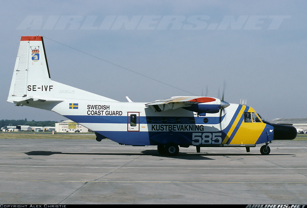
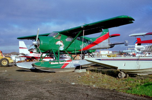
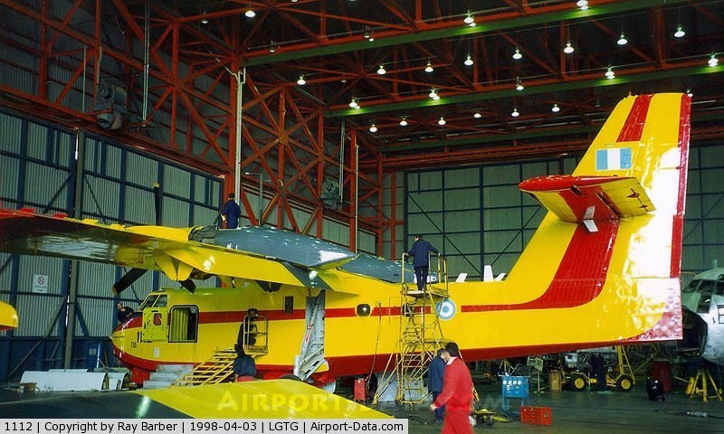
Kustbevakningen (The Swedish Coastguard), henceforth called KBV, intended on that particular day to perform two routine maritime surveillance tasks with flights over the southern Baltic Sea and along the south and west coasts of Sweden, including a flight over the Kattegatt. The flights would be carried out by the aircraft registered SE-IVF, with call sign 585. The crew consisted of two pilots and two system operators. The first flight of the day would take off from Ronneby, with Malmö/Sturup as the landing airport. According to the submitted flight plan the flight from Ronneby would depart north-east outwards across the southern tip of Öland, via reporting point KOLJA and onwards to a point south of Gotland. Thereafter the route would be via KOLJA back on a south-west course to a point south of Smygehamn in the southern Baltic Sea and then directly to Malmö/Sturup airport.

The take off from Ronneby
When KBV 585 taxied out for take off, route clearance had been obtained for take off in accordance with the submitted flight plan. The flight would be undertaken in VFR (Visual Flight Rules) weather conditions. The flight plan did not state the desired altitude, so at the initiative of air traffic control KBV 585 was assigned the altitude band “1500 feet or lower” in connection with the flight clearance. Take off was at 11:09 on runway 19. Immediately after take off the crew requested a “360”, i.e. to make a complete turn from their current position. This request was accepted by air traffic control and KBV 585 performed a circuit at about 500 feet in a left turn around the airfield. No comments or explanations were offered by the crew during this manoeuvre. In an interview with SHK the air traffic controller stated that he thought that the aircraft had suffered a technical fault and/or the crew wanted to carry out some form of check. It later transpired that the reason for the extra circuit may have been to show off the aircraft to a practical work experience student who was at the KBV as part of work experience training. After the completed left hand circuit the pilots returned to their original flight plan and continued, with an initial climb to the south, to then turn left and follow the planned flight route.

The first phase of the flight
During the continuing climb the pilots received an instruction to change radio frequency from Ronneby air traffic control tower to Ronneby control, i.e. the air traffic control section covering the Ronneby terminal area, that normally includes radar surveillance. As KBV 585 continued to climb, the air traffic controller noted that it continued to climb above the maximum altitude of 1500 feet that the stated flight clearance had included. At about 2000 feet while still climbing the pilots requested permission to climb to and maintain 2500 feet, which was granted. When the aircraft left the Ronneby terminal area the pilots changed radio frequency without reporting this to the air traffic control area controller. The air traffic controller on duty on that particular day at Ronneby stated that this was unusual behaviour by the KBV pilot, both to climb through the cleared altitude and to depart from the radio frequency without reporting it. The flight continued to the north-west in accordance with the flight plan. Apart from the routine tasking order concerning environmental and fishing surveillance, the tasking included instructions to search for traces from a previously sunken barge. The flight was performed without any problems being reported. During the flight the pilots were in radio contact both with air traffic controllers and the KBV coordination centre. As the aircraft was en route south-west after having turned at the southern tip of Gotland, the crew received a message from the coordination centre concerning a request they had received to perform a fly-by over Falsterbo. KBV has a base at the Falsterbo canal, which on that particular day was hosting a study visit by two school classes. Therefore a request came from the base to ask whether the pilots could consider performing a fly-by as they were on their way to Malmö/Sturup, so as to demonstrate the aircraft. The pilots accepted this and revised the final part of their flight plan so that a demonstration of the aircraft over the Falsterbo canal could be performed.

The fly-by over the KBV base
At 13:23 KBV 585 came in over the coast at Falsterbonäset on a north-northwesterly course along the canal. The aircraft then continued out over the sea and after a left turn returned to approach the base. The aircraft then performed another fly-by at low speed over the base and along the canal in the opposite direction, i.e. south-south-east, at low altitude. The route of the flight was partly over the canal, partly over the strip of beach and the buildings along the north-eastern shore. Beyond the far end of the canal the aircraft performed a 180 degrees left turn, first climbing and then descending. On its last approach to the base the aircraft came over the beach at the northeastern side of the canal, on a north-westerly course, which was later altered to north-north-westerly as it once again came over the canal.
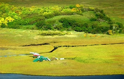
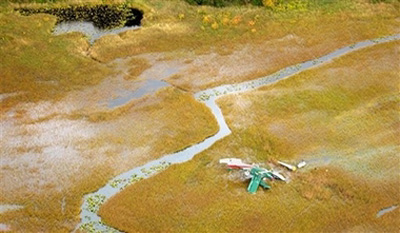
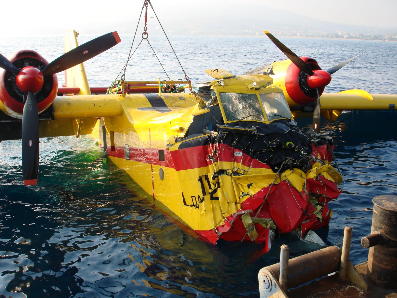
The accident
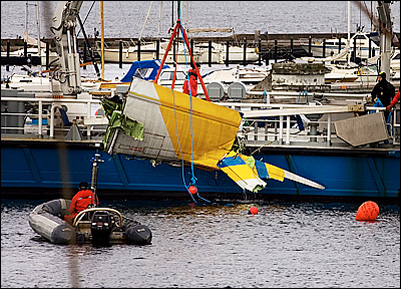
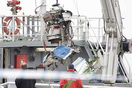
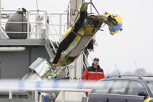
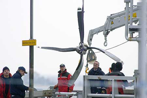
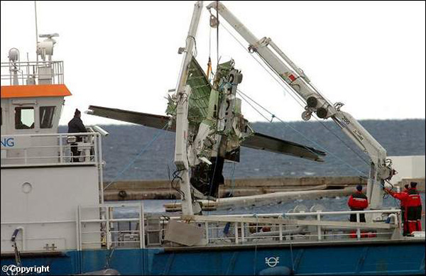
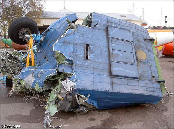
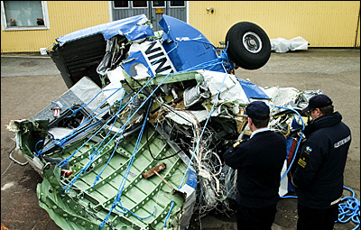
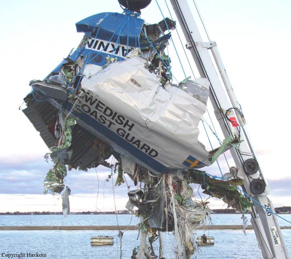
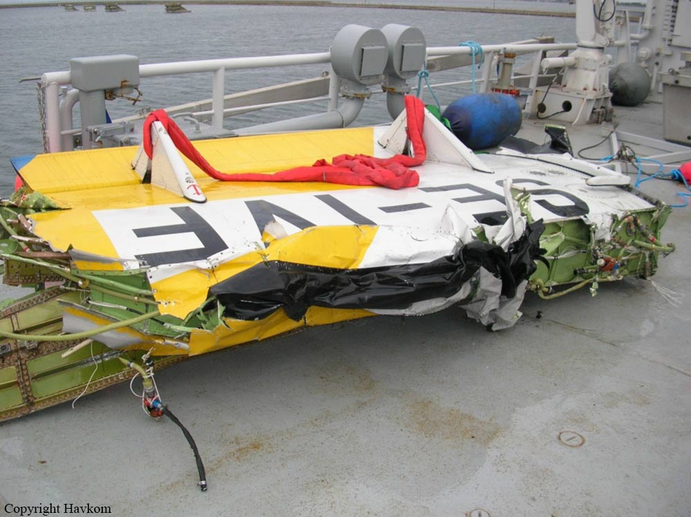
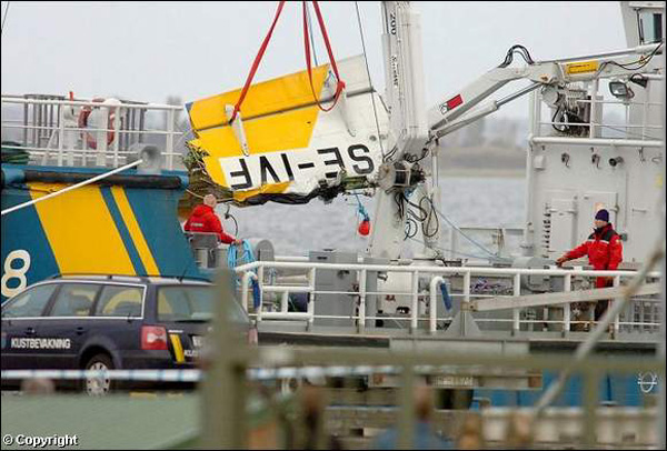
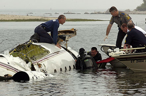
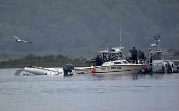
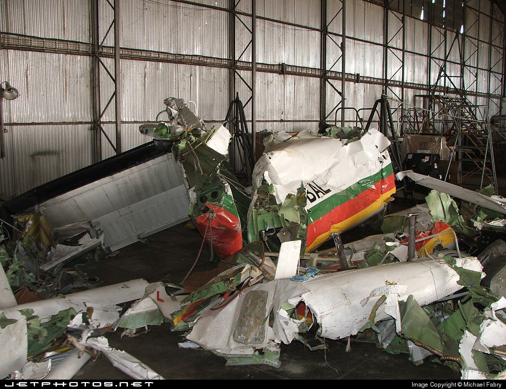
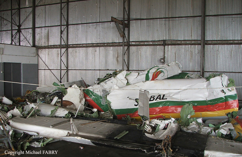
As the aircraft neared the base once more it began wing tipping. After two or three wing tippings, by which time the aircraft was approximately above the bridge at the north-west entrance to the canal, a loud bang was heard and the entire left wing separated from the aircraft, to fall into the basin. The aircraft then rolled over onto its back and also fell into the basin, somewhat further out. The impact created a huge cascade of water. The remains of the aircraft and wing then quickly sank to the bottom. The whole sequence of events took place quickly and afterwards various pieces of wreckage could be seen floating on the surface at the point of impact. All on board were fatally injured. The accident took place at position 55° 25' N 012° 56' E; at sea level.
Probable cause:
The accident was caused by an inadequate maintenance system in respect of inspections for fatigue cracks. Contributory to the crack formation has been an unsuitable design of the attachment of the wings to the aircraft fuselage.
Final Report:

Crash of a De Havilland DHC-2 Beaver I in Swikshak: 1 killed

Date & Time: Sep 21, 2006 at 1315 LT
Type of aircraft:
Operator:
Registration:
N5154G
Survivors:
Yes
Schedule:
Kodiak - Igiugig
MSN:
405
YOM:
1952
Crew on board:
1
Crew fatalities:
Pax on board:
5
Pax fatalities:
Other fatalities:
Total fatalities:
1
Captain / Total flying hours:
4770
Captain / Total hours on type:
1860.00
Aircraft flight hours:
11613
Circumstances:
The airline transport pilot was departing to the north from a narrow stream in a float-equipped airplane with lodge guests aboard, on a Title 14, CFR Part 91 flight. Northerly winds between 25 and 35 knots, were reported at the time of the accident. The accident pilot reported that after departure, he turned left, and a strong downdraft "threw the airplane to the ground." The passengers said that the airplane started its takeoff run directly into the strong winds, but shortly after becoming airborne, the pilot made a steep turn to the left, about 150 feet above the ground. The passengers indicated that as the airplane continued to turn left, it began to shudder and buffet, then abruptly descended nose low into the marsh-covered terrain. During the impact, the right wing folded, and the airplane's fuselage came to rest on its right side. One of the occupants, seated next to the right main cabin door, was partially ejected during the impact sequence, and was pinned under the fuselage and covered by water. Rescue efforts by the pilot and passengers were unsuccessful. In the pilot's written statement to the NTSB, he reported that there were no pre accident mechanical anomalies with the airplane, and during the on-site examination of the wreckage by the NTSB investigator-in-charge, no pre accident mechanical anomalies were discovered.
Probable cause:
The pilot's failure to maintain adequate airspeed while maneuvering to reverse direction, which resulted in an inadvertent stall and an uncontrolled descent. Factors associated with the accident were the inadvertent stall and wind gusts.
Final Report:

Crash of a Cessna T303 Crusader off Aldeburgh

Date & Time: Sep 19, 2006 at 1328 LT
Type of aircraft:
Operator:
Registration:
D-IAFC
Flight Phase:
Flight Type:
Survivors:
Yes
Schedule:
Braunschweig – Oxford
MSN:
303-00244
YOM:
1983
Region:
Crew on board:
1
Crew fatalities:
Pax on board:
0
Pax fatalities:
Other fatalities:
Total fatalities:
0
Captain / Total flying hours:
24000
Captain / Total hours on type:
6000.00
Circumstances:
Whilst on a cargo flight from Braunschweig, Germany, to Oxford, England, when approximately 30 nm from the English coast, the right engine started to run roughly. On checking the fuel gauges, the pilot observed that they were indicating in the ‘red sector’. The right engine subsequently stopped, shortly followed by the left engine. The aircraft then glided from FL100 towards the Suffolk coast and ditched in the sea approximately 9.5 nm southeast of Aldeburgh. The pilot was able to abandon the aircraft, which sank quickly. He was rescued from the sea some 18 minutes later by a Royal Air Force Search and Rescue helicopter and taken to hospital, where he was found to have suffered a fractured a vertebra. The investigation determined that the aircraft had run out of fuel, due to insufficient fuel for the intended journey being on-board the aircraft at the start of the flight.
Probable cause:
The accident occurred as a result of the aircraft running out of fuel approximately 160 nm short of its destination. Although the wreckage of the aircraft was not recovered, all the evidence suggests that this occurred due to insufficient fuel being on-board the aircraft prior to departure, rather than because of a technical problem. The pilot’s lack of awareness of the fuel quantity and the actual weight of the cargo on board D-IAFC prior to takeoff, are considered to have been significant causal factors in the accident. A contributory factor was that the pilot did not monitor the reportedly ‘unreliable’ fuel gauges, thus missing a chance to notice the aircraft’s low fuel state and divert to a suitable airfield before the situation became critical.
Final Report:

Crash of a Rockwell Grand Commander 690A off Anchorage: 3 killed

Date & Time: Jul 28, 2006 at 2037 LT
Registration:
N57096
Flight Type:
Survivors:
No
Schedule:
Kenai - Anchorage
MSN:
690-11120
YOM:
1973
Crew on board:
2
Crew fatalities:
Pax on board:
1
Pax fatalities:
Other fatalities:
Total fatalities:
3
Captain / Total flying hours:
4600
Copilot / Total flying hours:
9200
Aircraft flight hours:
11340
Circumstances:
The crew of the missing airplane was conducting a local area familiarization flight under Title 14, CFR Part 91. At the time of the flight, visual meteorological conditions prevailed, with occasional moderate turbulence forecast for the area. The airplane was routinely contracted for animal and bird counts, and the flight was to include low level flight simulating such a mission. The three occupants of the airplane were the pilot, company check pilot, and another company pilot riding along as a passenger. Both the pilot and the check pilot held airline transport certificates, and were experienced in the make and model of the accident airplane. The airplane was equipped with a satellite position reporting device that updated position, groundspeed, and altitude every 2 minutes. Radar and GPS track information indicated the accident airplane was flying low and slow along a peninsula coast over a saltwater inlet, and turned toward the center of the inlet. The track stopped about 3 miles offshore. The data indicated that while flying along the inlet, the airplane descended to 112 feet above ground level (water), and climbed as high as 495 feet, which was the airplane's altitude at the last data point. The airplane's groundspeed varied between 97 and 111 knots. The area of the presumed crash site experiences extreme tides and strong currents, with reduced visibility due to a high glacial silt content. An extensive search was conducted, but the airplane and its occupants have not been located. An examination of the airplane's maintenance logs did not disclose any unresolved maintenance issues.
Probable cause:
Undetermined; the airplane and its occupants are missing.
Final Report:

Crash of a Douglas DC-3C off Charlotte Amalie

Date & Time: Jul 19, 2006 at 0720 LT
Type of aircraft:
Operator:
Registration:
N782T
Flight Phase:
Flight Type:
Survivors:
Yes
Schedule:
Charlotte Amalie - San Juan
MSN:
4382
YOM:
1942
Crew on board:
2
Crew fatalities:
Pax on board:
0
Pax fatalities:
Other fatalities:
Total fatalities:
0
Captain / Total flying hours:
15750
Copilot / Total flying hours:
305
Aircraft flight hours:
32278
Circumstances:
The captain stated that the accident flight was a return flight to San Juan, Puerto Rico, after delivering U.S. Mail. The airplane was empty of cargo at the time of the accident. The first officer was flying the airplane. The takeoff roll and rotation at 84 knots was uneventful until about 100 feet above the ground when the gear was called out to be retracted. At that time, the left engine's rpm dropped from 2,700 to 1,000. He communicated to the first officer that he would be assuming control of the airplane. He then proceeded with verifying that the left engine had failed. Once confirmed, he proceeded with the failed engine check list and feathering the propeller. They advised air traffic control (ATC) of the situation and informed them that they were returning to land. The airplane would not maintain altitude and the airspeed dropped to about 75 knots. The captain stated that he knew the airplane would not make it back to the airport. Instructions were given to the two passengers to don their life vests and prepared for a ditching. The captain elected to perform a controlled flight into the water. All onboard managed to exit the airplane through the cockpit overhead escape hatch onto the life raft as the airplane remained afloat. About ten minutes later the airplane sank nose first straight down. The airplane came to rest at the bottom of the ocean, in about 100 feet of water. The airplane was not recovered. Underwater photos provided by the operator showed the nose and cockpit area caved in, the left engine's propeller was in the feathered position, and the right engine's propeller was in a low pitch position.
Probable cause:
The airplane's inability to maintain altitude for undetermined reasons, following a loss of power from the left engine.
Final Report:

Crash of a Canadair CL-215-1A10 off Patroklos Island

Date & Time: Jul 6, 2006 at 0930 LT
Type of aircraft:
Operator:
Registration:
1112
Flight Type:
Survivors:
Yes
MSN:
1112
YOM:
1990
Country:
Region:
Crew on board:
2
Crew fatalities:
Pax on board:
0
Pax fatalities:
Other fatalities:
Total fatalities:
0
Circumstances:
The aircraft was taking part to a fire fighting mission on the Tzia Island. While returning to scope in the Saronic Gulf, the aircraft struck a wave and came to rest off the Patroklos Island. Both pilots were rescued by the crew of a Super Puma helicopter from the Greek Navy while the aircraft was recovered but damaged beyond repair.

Crash of a Learjet 35A off Groton: 2 killed

Date & Time: Jun 2, 2006 at 1440 LT
Type of aircraft:
Operator:
Registration:
N182K
Survivors:
Yes
Schedule:
Atlantic City - Groton
MSN:
35-293
YOM:
1980
Crew on board:
2
Crew fatalities:
Pax on board:
3
Pax fatalities:
Other fatalities:
Total fatalities:
2
Captain / Total flying hours:
18750
Captain / Total hours on type:
7500.00
Copilot / Total flying hours:
3275
Copilot / Total hours on type:
289
Aircraft flight hours:
11704
Circumstances:
The crew briefed the Instrument Landing System approach, including the missed approach procedures. Weather at the time included a 100-foot broken cloud layer, and at the airport, 2 miles visibility. The approach was flown over water, and at the accident location, there was dense fog. Two smaller airplanes had successfully completed the approach prior to the accident airplane. The captain flew the approach and the first officer made 100-foot callouts during the final descent, until 200 feet above the decision height. At that point, the captain asked the first officer if he saw anything. The first officer reported "ground contact," then noted "decision height." The captain immediately reported "I got the lights" which the first officer confirmed. The captain reduced the power to flight idle. Approximately 4 seconds later, the captain attempted to increase power. However, the engines did not have time to respond before the airplane descended into the water and impacted a series of approach light stanchions, commencing about 2,000 feet from the runway. Neither crew member continued to call out altitudes after seeing the approach lights, and the captain descended the airplane below the decision height before having the requisite descent criteria. The absence of ground references could have been conducive to a featureless terrain illusion in which the captain would have believed that the airplane was at a higher altitude than it actually was. There were
no mechanical anomalies which would have precluded normal airplane operation.
Probable cause:
The crew's failure to properly monitor the airplane's altitude, which resulted in the captain's inadvertent descent of the airplane into water. Contributing to the accident were the foggy weather conditions, and the captain's decision to descend below the decision height without sufficient visual cues.
Final Report:

Crash of a De Havilland DHC-6 Twin Otter 300 off Santo Antonio: 4 killed

Date & Time: May 23, 2006 at 1822 LT
Registration:
S9-BAL
Flight Type:
Survivors:
No
Schedule:
Santo Antonio - Santo Antonio
MSN:
648
YOM:
1979
Region:
Crew on board:
4
Crew fatalities:
Pax on board:
0
Pax fatalities:
Other fatalities:
Total fatalities:
4
Circumstances:
The twin engine aircraft departed Santo Antonio Airport on a local training flight, carrying four pilots. While on approach to runway 29, the aircraft went out of control and crashed in the sea few km offshore. All four occupants were killed.