Crash of a Britten-Norman BN-2B-21 Islander near Fort-de-France: 6 killed

Date & Time: Jul 17, 1994 at 2145 LT
Type of aircraft:
Operator:
Registration:
8P-TAD
Survivors:
No
Site:
Schedule:
Bridgetown - Fort-de-France
MSN:
2152
YOM:
1983
Country:
Crew on board:
1
Crew fatalities:
Pax on board:
5
Pax fatalities:
Other fatalities:
Total fatalities:
6
Captain / Total flying hours:
2000
Captain / Total hours on type:
1400.00
Circumstances:
On Monday July 18 1995 at 00h45 UTC, expressed in local time as Sunday July 17 at 20h45, the Trans Island Air Britten-Norman BN2B registered as 8P-TAD, took off from Grantley Adams airport (Barbados) bound for Fort de France (Martinique) with one pilot and five passengers on board. The flight had been preceded by another aircraft, registered as 8P-TAC, of the same type and belonging to the same company, flying the same route. These flights were undertaken on a charter basis on behalf of Société Nouvelle Air Martinique. They were carrying passengers originally scheduled to fly on a Dornier 228 which was out of service, and which was supposed to undertake scheduled flight PN403. At 01h39, at the request of the approach controller, the pilot announced his estimated arrival time over the FOF beacon at 01h47. At 01h40 the pilot said that he was at 2700 feet, thus at the minimum arrival altitude in that sector, still on the 150 radial from FOF; he stated that he had the field in sight and requested permission to make a visual approach. At 01h42, at the request of the controller, the pilot confirmed that he had the field in sight and obtained clearance for a visual approach. At 01h45, the pilot of 8P-TAD transmitted for the last time. At 01h48, he no longer responded to the controller's calls. At 01h58, the DETRESFA phase of the search and rescue procedure was initiated. On July 19 1994 at around 08h30, a day and a half after the accident, the wreckage of the aircraft was found in the Carbet hills, near Piton Lacroix in the
commune of Bellefontaine.
Probable cause:
The accident was caused by the pilot's failure to identify the airdrome installations before the start of the night visual approach procedure under an IFR flight plan. The probable failure of the onboard DME and the imprecise navigation contributed to the accident.
Final Report:

Crash of an Antonov AN-24B in Kherson

Date & Time: Jul 17, 1994 at 1154 LT
Type of aircraft:
Operator:
Registration:
RA-46575
Flight Phase:
Survivors:
Yes
Schedule:
Kherson - Moscow
MSN:
87304810
YOM:
1968
Flight number:
BV086
Country:
Region:
Crew on board:
4
Crew fatalities:
Pax on board:
28
Pax fatalities:
Other fatalities:
Total fatalities:
0
Circumstances:
During the takeoff roll, at a speed of 135 km/h, the pilot-in-command slowly started the rotation and the nose gear lifted off. Then, at a speed of 165 km/h, he lifted off more vigorously when the flight engineer retracted the landing gear. At a speed of 190 km/h, the aircraft sank back on the runway on its belly (the landing gears were partially retracted), causing both propellers to struck the ground. The aircraft slid for about 740 metres when eight seconds later, the flight engineer shut down both engines while both propellers were feathered 20 seconds later. The aircraft slid for another 300 metres then came to rest 1,670 metres from the departure point. All 32 occupants evacuated safely and the aircraft was damaged beyond repair.
Probable cause:
A lack of crew coordination during the takeoff roll procedure led the flight engineer retracting the undercarriage prematurely.

Crash of a Yakovlev Yak-40D in Boma: 5 killed

Date & Time: Jul 17, 1994
Type of aircraft:
Operator:
Registration:
RA-87256
Survivors:
Yes
Schedule:
Kinshasa - Boma
MSN:
9 31 13 26
YOM:
1973
Region:
Crew on board:
5
Crew fatalities:
Pax on board:
4
Pax fatalities:
Other fatalities:
Total fatalities:
5
Aircraft flight hours:
27402
Aircraft flight cycles:
22752
Circumstances:
The aircraft landed 45 metres past the runway 21 threshold at Boma Airfield (runway 21 is 1,082 metres long). The crew started the braking procedure and both engines n°1 & 3 were shut down after a course of about 400-500 metres. At a distance of 200 metres from the runway end, the captain elected to veer to the right to avoid an overrun when the aircraft went down an embankment and came to rest in a 8 metres deep ravine, bursting into flames. Four people were injured and five others were killed. The aircraft was destroyed.
Probable cause:
Wrong approach configuration on part of the crew who landed at an excessive speed. The following contributing factors were reported:
- Poor efficient braking,
- The aircraft speed upon landing was exceeding the aircraft flight manual,
- Uncoordinated actions of the crew on the application of the main and emergency braking that were used simultaneously which is non compliant with published procedures,
- Erroneous shutdown of the central engine (n°2) during the first half of run.

Crash of a Fokker F27 Friendship 200 in Dera Ismail Khan

Date & Time: Jul 6, 1994 at 1025 LT
Type of aircraft:
Operator:
Registration:
AP-ALN
Survivors:
Yes
Schedule:
Islamabad – Peshawar – Dera Ismail Khan
MSN:
10164
YOM:
1960
Flight number:
PK684
Country:
Region:
Crew on board:
4
Crew fatalities:
Pax on board:
38
Pax fatalities:
Other fatalities:
Total fatalities:
0
Circumstances:
On approach to Dera Ismail Khan Airport, the crew encountered technical problems with the left engine. The captain decided to initiate a go-around. Flaps and undercarriage were retracted when the aircraft entered a stall condition, lost height and crashed in an open field. It slid on the ground for about 300 metres before coming to rest against trees. All 42 occupants were evacuated, among them three passengers were injured.

Crash of a Douglas DC-9-31 in Charlotte: 37 killed

Date & Time: Jul 2, 1994 at 1843 LT
Type of aircraft:
Operator:
Registration:
N954VJ
Survivors:
Yes
Site:
Schedule:
Columbia - Charlotte
MSN:
47590
YOM:
1973
Flight number:
US1016
Crew on board:
5
Crew fatalities:
Pax on board:
52
Pax fatalities:
Other fatalities:
Total fatalities:
37
Captain / Total flying hours:
8065
Captain / Total hours on type:
1970.00
Copilot / Total flying hours:
12980
Copilot / Total hours on type:
3180
Aircraft flight hours:
53917
Aircraft flight cycles:
63147
Circumstances:
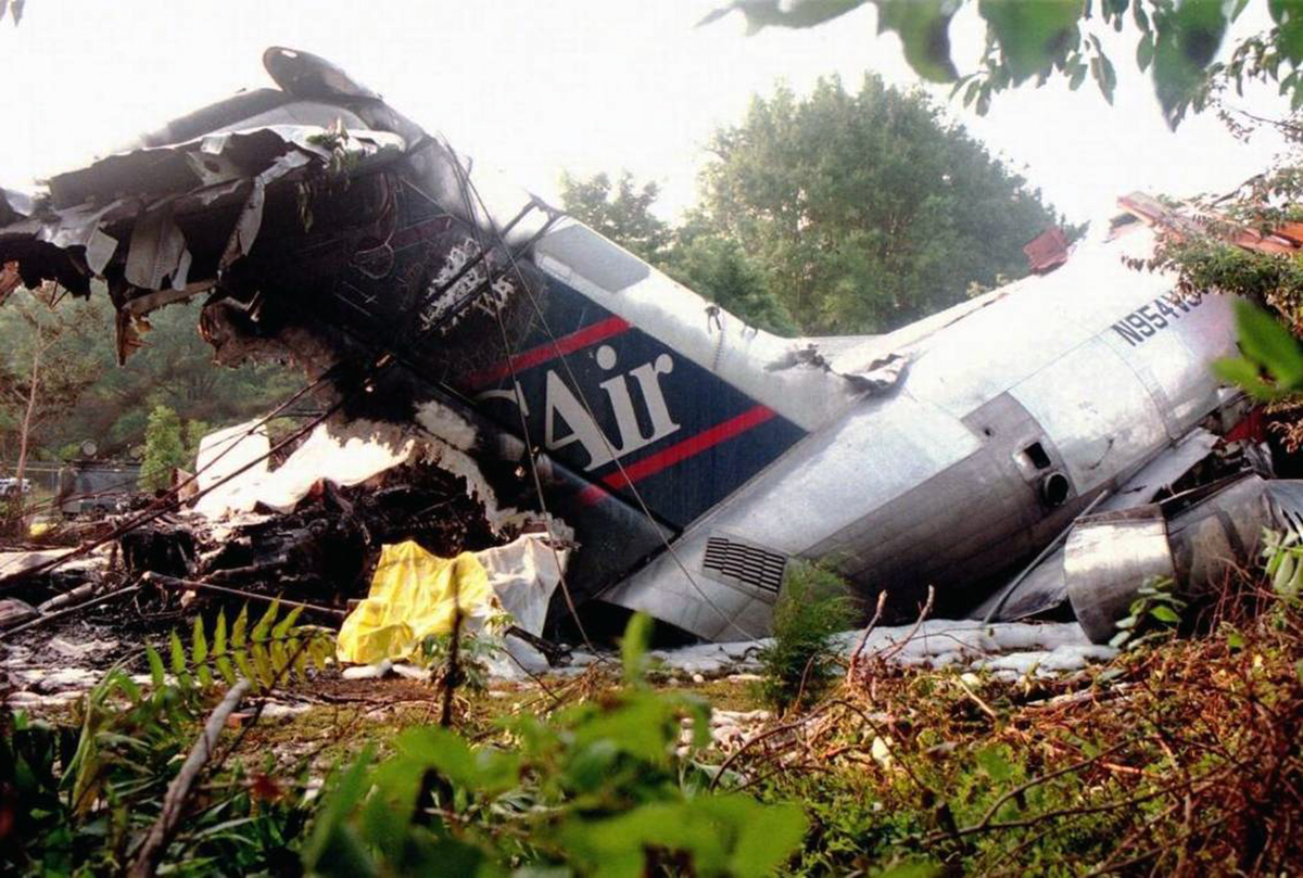
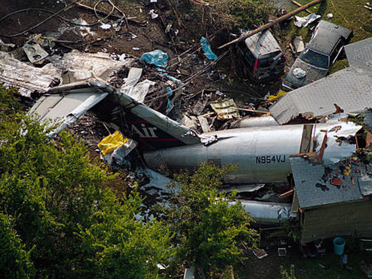
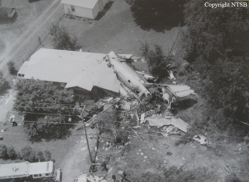
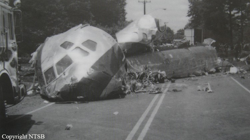
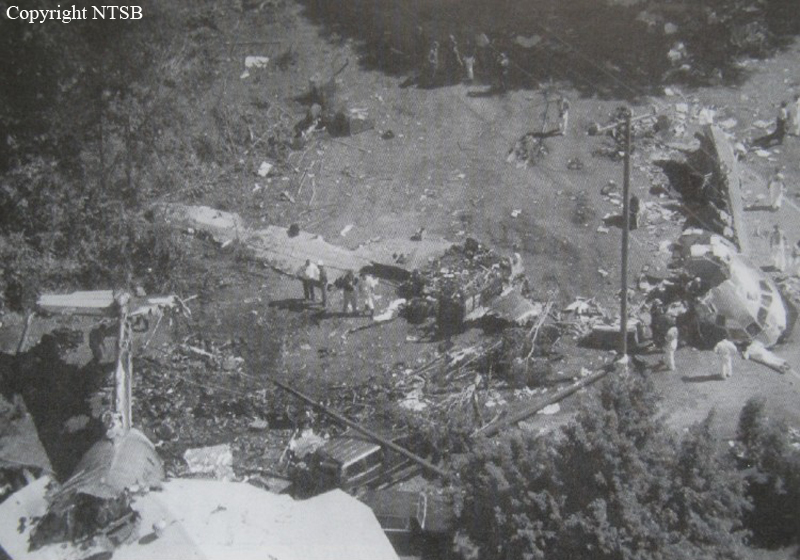
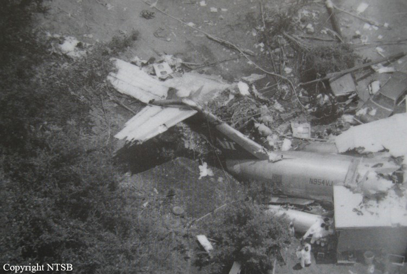
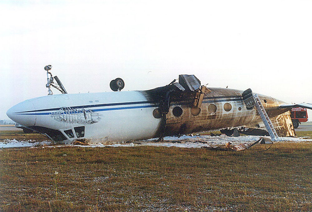
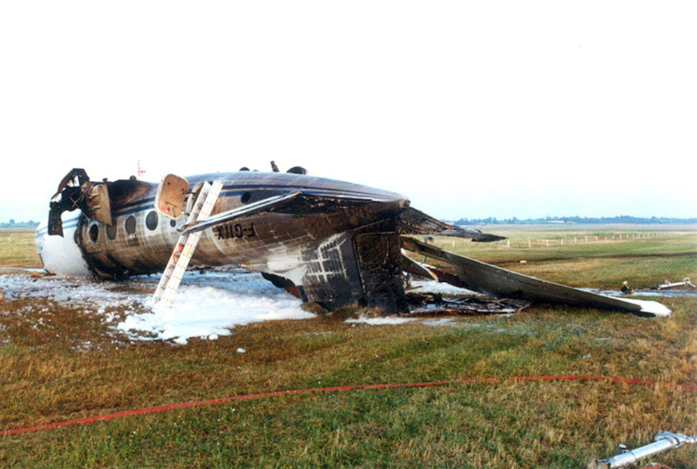
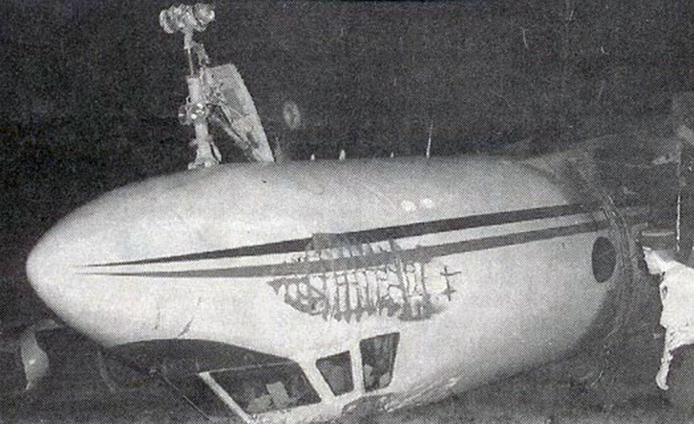
USAir Flight 1016 was a domestic flight from Columbia (CAE) to Charlotte (CLT). The DC-9 departed the gate on schedule at 18:10. The first officer was performing the duties of the flying pilot. The weather information provided to the flightcrew from USAir dispatch indicated that the conditions at Charlotte were similar to those encountered when the crew had departed there approximately one hour earlier. The only noted exception was the report of scattered thunderstorms in the area. Flight 1016 was airborne at 18:23 for the planned 35 minute flight. At 18:27, the captain of flight 1016 made initial contact with the Charlotte Terminal Radar Approach Control (TRACON) controller and advised that the flight was at 12,000 feet mean sea level (msl). The controller replied "USAir ten sixteen ... expect runway one eight right." Shortly afterward the controller issued a clearance to the flightcrew to descend to 10,000 feet. At 18:29, the first officer commented "there's more rain than I thought there was ... it's startin ...pretty good a minute ago ... now it's held up." On their airborne weather radar the crew observed two cells, one located south and the second located east of the airport. The captain said "looks like that's [rain] setting just off the edge of the airport." One minute later, the captain contacted the controller and said "We're showing uh little buildup here it uh looks like it's sitting on the radial, we'd like to go about five degrees to the left to the ..." The controller replied "How far ahead are you looking ten sixteen?" The captain responded "About fifteen miles." The controller then replied "I'm going to turn you before you get there I'm going to turn you at about five miles northbound." The captain acknowledged the transmission, and, at 18:33, the controller directed the crew to turn the aircraft to a heading of three six zero. One minute later the flightcrew was issued a clearance to descend to 6,000 feet, and shortly thereafter contacted the Final Radar West controller. At 18:35 the Final Radar West controller transmitted "USAir ten sixteen ... maintain four thousand runway one eight right.'' The captain acknowledged the radio transmission and then stated to the first officer "approach brief." The first officer responded "visual back up ILS." Following the first officer's response, the controller issued a clearance to flight 1016 to "...turn ten degrees right descend and maintain two thousand three hundred vectors visual approach runway one eight right.'' At 18:36, the Final Radar West controller radioed flight 1016 and said "I'll tell you what USAir ten sixteen they got some rain just south of the field might be a little bit coming off north just expect the ILS now amend your altitude maintain three thousand." At 18:37, the controller instructed flight 1016 to ''turn right heading zero niner zero." At 18:38, the controller said "USAir ten sixteen turn right heading one seven zero four from SOPHE [the outer marker for runway 18R ILS] ... cross SOPHE at or above three thousand cleared ILS one eight right approach." As they were maneuvering the airplane from the base leg of the visual approach to final, both crew members had visual contact with the airport. The captain then contacted Charlotte Tower. The controller said "USAir ten sixteen ... runway one eight right cleared to land following an F-K one hundred short final, previous arrival reported a smooth ride all the way down the final." The pilot of the Fokker 100 in front also reported a "smooth ride". About 18:36, a special weather observation was recorded, which included: ... measured [cloud] ceiling 4,500 feet broken, visibility 6 miles, thunderstorm, light rain shower, haze, the temperature was 88 degrees Fahrenheit, the dewpoint was 67 degrees Fahrenheit, the wind was from 110 degrees at 16 knots .... This information was not broadcast until 1843; thus, the crew of flight 1016 did not receive the new ATIS. At 18:40, the Tower controller said "USAir ten sixteen the wind is showing one zero zero at one nine." This was followed a short time later by the controller saying "USAir ten sixteen wind now one one zero at two one." Then the Tower controller radioed a wind shear warning "windshear alert northeast boundary wind one nine zero at one three.'' On finals the DC-9 entered an area of rainfall and at 18:41:58, the first officer commented "there's, ooh, ten knots right there." This was followed by the captain saying "OK, you're plus twenty [knots] ... take it around, go to the right." A go around was initiated. The Tower controller noticed Flight 1016 going around "USAir ten sixteen understand you're on the go sir, fly runway heading, climb and maintain three thousand." The first officer initially rotated the airplane to the proper 15 degrees nose-up attitude during the missed approach. However, the thrust was set below the standard go-around EPR limit of 1.93, and the pitch attitude was reduced to 5 degrees nose down before the flightcrew recognized the dangerous situation. When the flaps were in transition from 40 to 15 degrees (about a 12-second cycle), the airplane encountered windshear. Although the DC-9 was equipped with an on-board windshear warning system, it did not activate for unknown reasons. The airplane stalled and impacted the ground at 18:42:35. Investigation revealed that the headwind encountered by flight 1016 during the approach between 18:40:40 and 18:42:00 was between 10 and 20 knots. The initial wind component, a headwind, increased from approximately 30 knots at 18:42:00 to 35 knots at 18:42:15. The maximum calculated headwind occurred at 18:42:17, and was calculated at about 39 knots. The airplane struck the ground after transitioning from a headwind of approximately 35 knots, at 18:42:21, to a tailwind of 26 knots (a change of 61 knots), over a 14 second period.
Probable cause:
The board determines that the probable cause of the accident was:
- The flight crew's decision to continue an approach into severe convective activity that was conducive to a microburst,
- The flight crew's failure to recognize a windshear situation in a timely manner,
- The flight crew's failure to establish and maintain the proper airplane attitude and thrust setting necessary to escape the windshear,
- The lack of real-time adverse weather and windshear hazard information dissemination from air traffic control, all of which led to an encounter with and failure to escape from a microburst-induced windshear that was produced by a rapidly developing thunderstorm located at the approach end of runway 18R.
The following contributing factors were reported:
- The lack of air traffic control procedures that would have required the controller to display and issue ASR-9 radar weather information to the pilots of flight 1016,
- The Charlotte tower supervisor's failure to properly advise and ensure that all controllers were aware of and reporting the reduction in visibility and the RVR value information, and the low level windshear alerts that had occurred in multiple quadrants,
- The inadequate remedial actions by USAir to ensure adherence to standard operating procedures,
- The inadequate software logic in the airplane's windshear warning system that did not provide an alert upon entry into the windshear.
Final Report:

Crash of a Fokker F28 Fellowship 4000 in Tidjikdja: 80 killed

Date & Time: Jul 1, 1994 at 0820 LT
Type of aircraft:
Operator:
Registration:
5T-CLF
Survivors:
Yes
Schedule:
Nouakchott - Tidjikdja
MSN:
11092
YOM:
1975
Flight number:
MR251
Country:
Region:
Crew on board:
4
Crew fatalities:
Pax on board:
89
Pax fatalities:
Other fatalities:
Total fatalities:
80
Circumstances:
On approach to Tidjikdja Airport, the crew encountered poor visibility due to a sandstorm. Unable to establish a visual contact with the runway, the captain initiated a go-around procedure. Few minutes later, the crew attempted a second approach while the weather conditions did not improve. At a height of about 25 metres above the airfield, the aircraft nosed down and violently struck the runway surface. Upon impact, the undercarriage were torn off and out of control, the aircraft veered off runway and eventually collided with rocks, bursting into flames. Thirteen passengers were rescued while 80 other occupants were killed.
Probable cause:
The approach was completed in below weather minima and the crew continued the descent without establishing a visual contact with the ground and runway. At the time of the accident, the visibility and the RVR were below minimums. Considering the situation, the crew should divert to another suitable airport.

Crash of a Grumman G-159 Gulfstream GI in Lyon

Date & Time: Jun 29, 1994 at 2000 LT
Type of aircraft:
Operator:
Registration:
F-GIIX
Survivors:
Yes
Schedule:
Rouen - Lyon
MSN:
128
YOM:
1964
Country:
Region:
Crew on board:
3
Crew fatalities:
Pax on board:
24
Pax fatalities:
Other fatalities:
Total fatalities:
0
Circumstances:
On approach to Lyon-Satolas Airport, the crew realized he was not properly aligned with the runway centerline and decided to initiate a go-around procedure. Power was added on both engines but the left engine failed to respond. The aircraft lost height and struck the runway surface with its left wing, bounced, overturned and came to rest upside down, bursting into flames. All 27 occupants were evacuated, among them nine were injured. The aircraft was destroyed.

Crash of a Fokker F27 Friendship 400M in Abidjan: 17 killed

Date & Time: Jun 26, 1994 at 1941 LT
Type of aircraft:
Operator:
Registration:
TU-TIP
Survivors:
No
Schedule:
San Pedro - Abidjan
MSN:
10577
YOM:
1978
Flight number:
VU777
Location:
Country:
Region:
Crew on board:
3
Crew fatalities:
Pax on board:
14
Pax fatalities:
Other fatalities:
Total fatalities:
17
Circumstances:
While descending to Abidjan-Félix Houphouët-Boigny Airport runway 21 by night, the captain reported runway in sight and was instructed by ATC to report on final. Few seconds later, the aircraft nosed down, entered an uncontrolled descent and crashed 4 km short of runway, bursting into flames. The aircraft was destroyed and all 17 occupants were killed.
Probable cause:
The exact cause of the loss of control could not be determined. At the time of the accident, the aircraft was not in an approach configuration as undercarriage and flaps were not deployed. The speed and the rate of descent were excessive for unknown reasons.

Crash of a PZL-Mielec AN-2P in Kirensk

Date & Time: Jun 25, 1994
Type of aircraft:
Operator:
Registration:
CCCP-70263
Flight Phase:
Survivors:
Yes
MSN:
1G139-22
YOM:
1972
Country:
Region:
Crew on board:
2
Crew fatalities:
Pax on board:
6
Pax fatalities:
Other fatalities:
Total fatalities:
0
Circumstances:
During initial climb, the engine failed. The aircraft stalled and crashed, bursting into flames. All eight occupants escaped uninjured (or with minor injuries) while the aircraft was destroyed.
Probable cause:
Engine failure during climb out for unknown reasons.

Crash of a De Havilland DHC-2 Beaver near Hunter Point: 2 killed

Date & Time: Jun 23, 1994 at 1100 LT
Type of aircraft:
Operator:
Registration:
C-FDTI
Flight Phase:
Survivors:
No
Schedule:
Hunter Point – Sandspit
MSN:
37
YOM:
1949
Country:
Crew on board:
1
Crew fatalities:
Pax on board:
1
Pax fatalities:
Other fatalities:
Total fatalities:
2
Captain / Total flying hours:
2586
Captain / Total hours on type:
1268.00
Aircraft flight hours:
11615
Circumstances:
The amphibious DHC-2 Beaver was being operated from the Harbour Air base at Sandspit, British Columbia, located on the Queen Charlotte Islands. On the first flight on the day of the accident, the aircraft carried baggage from the Sandspit Airport to a floating fishing resort at anchor in Givenchy Bay. This bay is located in the Kano Inlet on the west coast of the Queen Charlotte Islands, 28 nautical miles (nm) west of Sandspit. On board the aircraft with the pilot was a passenger who would remain with the flight for the return trip to Sandspit. The aircraft departed Sandspit under visual flight rules (VFR) at 1015 Pacific daylight time (PDT) and landed at the fishing resort at 1039. The pilot had taken the most direct route to the destination through a low pass and over Yakoun Lake. He advised the company dispatch on the company radio frequency that the weather was quite poor along that route and that he planned to take the Skidegate Channel for the return trip. On arrival at the Givenchy resort, the aircraft was loaded with the fish to be transported to Sandspit; it then departed Givenchy at 1051. When the aircraft did not arrive at Sandspit, a search was organized. The wreckage was located at 1245 at Hunter Point, about 7 nm from Givenchy, at latitude 53°15'N, longitude 132°42'W. The accident had occurred during the hours of daylight at approximately 1100. The aircraft was destroyed and the pilot and passenger were fatally injured upon impact.
Probable cause:
The aircraft likely stalled at an altitude insufficient to permit recovery. The reason why the aircraft may have stalled could not be determined.
Final Report: