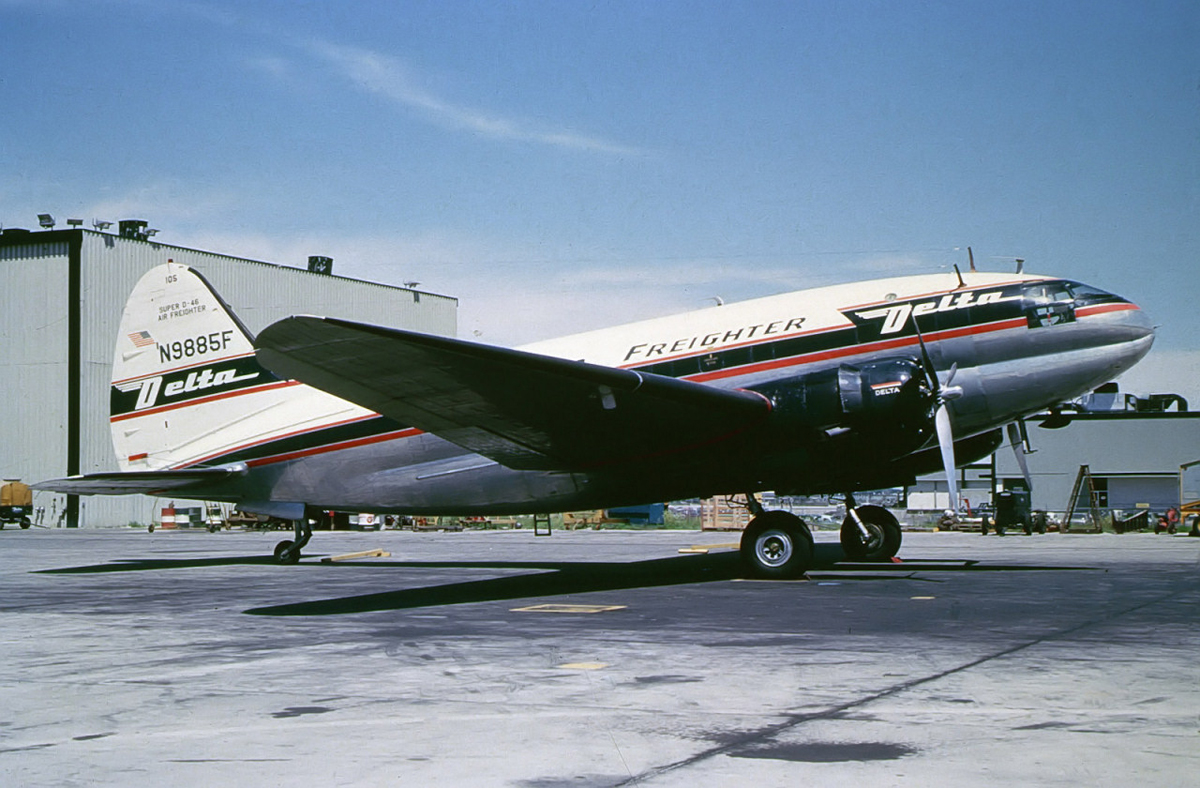
Crash of a Curtiss C-46 in Baton Rouge

Date & Time: Nov 24, 1964 at 1045 LT
Type of aircraft:
Operator:
Registration:
N9885F
Flight Type:
Survivors:
Yes
Schedule:
Atlanta-New Orleans
MSN:
32878
YOM:
1944
Flight number:
DL029
Crew on board:
2
Crew fatalities:
Pax fatalities:
Other fatalities:
Total fatalities:
0
Captain / Total flying hours:
7209
Captain / Total hours on type:
478.00
Aircraft flight hours:
19842
Circumstances:
Weather at New Orleans was below landing minima, so the flight was diverted to Baton Rouge. Weather at Baton Rouge was a ceiling 300 feet overcast, visibility 1,5 miles in light rain and fog, wind 360deg/5 knots. Runway 13 ILS minima were 300 feet ceiling and 3/4 mile visibility, weather was below circling minima. However, the approach was continued and the plane touched down fast 2,500 feet past the runway threshold. Approaching the end of the runway, the pilot attempted to ground loop, but the plane just turned 20° and slid off the runway. Both pilots were evacuates while the aircraft was damaged beyond repair.
Probable cause:
"Failure of the captain to execute a go around during a landing overshoot under existing unfavourable wind and adverse runway conditions. Ineffective braking caused by hydroplaning. The copilot completed the approach and the captain took over control after touchdown.
Final Report:

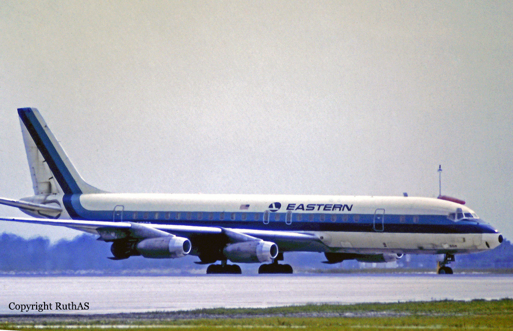
Crash of a Douglas DC-8-21 into the Lake Pontchartrain: 58 killed

Date & Time: Feb 25, 1964 at 0205 LT
Type of aircraft:
Operator:
Registration:
N8607
Flight Phase:
Survivors:
No
Schedule:
Mexico City – New Orleans – Atlanta – Philadelphia – New York
MSN:
45428
YOM:
1960
Flight number:
EA304
Crew on board:
7
Crew fatalities:
Pax on board:
51
Pax fatalities:
Other fatalities:
Total fatalities:
58
Captain / Total flying hours:
19160
Captain / Total hours on type:
916.00
Copilot / Total flying hours:
10734
Copilot / Total hours on type:
2404
Aircraft flight hours:
11340
Circumstances:
The flight, scheduled from Mexico City to New York City, with several intermediate stops, had just departed New Orleans at 0200. Three minutes later the captain acknowledged a request to change radio frequencies, but no further communications were received from the flight At 0205-40 the radar target associated with Flight 304 had disappeared from the scopes of both the radar controllers who were observing the flight. Moderate to severe turbulence existed in the area at the time of the accident. At 0159 46 the local controller in the tower observed Flight 304 commence the takeoff. The lift-off appeared normal, and at approximately 0201 he advised the flight to contact Departure Control, which was acknowledged. He estimated that the flight was two or three miles north of the airport when the lights disappeared into the overcast Voice communication and radar contact were established immediately between the flight and the departure controller who advised them to" . . turn right heading 030, be a vector north of J-37 (the planned route of flight)" While the flight continued on this vector, the departure controller contacted the New Orleans Air Route Traffic Control Center (ARTCC) The radar target was identified five miles north of the New Orleans VORTAC, and a radar handoff was effected at 0202 38. Flight 304 was instructed to "contact New Orleans Center radar, frequency 123.6 now." At 0203 15 the crew replied, "OK". This was the last transmission from the flight. At 0205 40, when no transmissions had been received from the flight, the center controller contacted the departure controller to verify that proper instructions had been given. During this conversation both controllers confirmed that the radar target associated with the flight had disappeared from both scopes, and emergency procedures were initiated shortly thereafter. The last position noted by the controllers was approximately eight miles from the New Orleans VORTAC on the 030-degree radial. The aircraft crashed at 14.5 miles on the 034-degree radial, in Lake Pontchartrain. The aircraft disintegrated on impact and all 58 occupants have been killed.
Probable cause:
The Board determines the probable cause of this accident was the degradation of aircraft stability characteristics in turbulence, because of abnormal longitudinal trim component positions.
Final Report:

Crash of a Douglas DC-7B off Pilottown: 42 killed

Date & Time: Nov 16, 1959 at 0055 LT
Type of aircraft:
Operator:
Registration:
N4891C
Flight Phase:
Survivors:
No
Schedule:
Miami – Tampa – New Orleans
MSN:
45355
YOM:
1958
Flight number:
NA967
Crew on board:
6
Crew fatalities:
Pax on board:
36
Pax fatalities:
Other fatalities:
Total fatalities:
42
Captain / Total flying hours:
14700
Captain / Total hours on type:
400.00
Copilot / Total flying hours:
8710
Copilot / Total hours on type:
400
Aircraft flight hours:
6578
Circumstances:
While cruising at an altitude of 14,000 feet by night and approaching the Louisiana Coast, the airplane disappeared from radar screens and crashed into the Gulf of Mexico about 30 miles east of Pilottown. Intensive sea and air searches resulted in finding nine floating bodies and a small amount of floating debris the following morning. None of this disclosed conclusive evidence as to the genesis of the accident. The main wreckage has not been located despite several well planned searches. There was no radio message of impending trouble or any distress call from the crew prior to the accident. All 42 occupants were killed in the crash.
Probable cause:
Analysis of this accident must rest almost entirely on circumstantial evidence for the aircraft's wreckage still lies on the bottom of the Gulf. There is little or no physical evidence upon which to explain this accident. The aircraft was airworthy at the tine of departure, the crew was competent, weather conditions were good, and when disaster struck, the flight was very close to being both on course and on schedule. No operational or maintenance item was found which can reasonably be linked to this accident. It may safely be concluded that there was no warning of the disaster. This is evident by the lack of any unusual radio messages. As has been detailed, the fire marks on bodies and on debris were of the type caused exclusively by a flash surface fire, probably both hot and brief, upon impact with the water. Because of the lack of physical evidence, the probable cause of this accident remains unknown.
Final Report:

Crash of a Douglas C-124A Globemaster II at Barksdale AFB

Date & Time: Jul 6, 1959
Operator:
Registration:
49-0254
Flight Phase:
Flight Type:
Survivors:
Yes
MSN:
43183
YOM:
1949
Crew on board:
7
Crew fatalities:
Pax on board:
0
Pax fatalities:
Other fatalities:
Total fatalities:
0
Circumstances:
Shortly after takeoff from Barksdale AFB, while in initial climb, the four engine aircraft stalled and crashed in flames. All seven crew members were quickly evacuated while the aircraft was totally destroyed by a post crash fire. The crew was engaged in a nuclear logistics movement mission.

Crash of a Kaiser-Frazer C-119J Flying Boxcar in Alexandria: 3 killed

Date & Time: Sep 6, 1955
Operator:
Registration:
51-8142
Flight Phase:
Flight Type:
Survivors:
Yes
MSN:
145
YOM:
1952
Crew on board:
6
Crew fatalities:
Pax on board:
0
Pax fatalities:
Other fatalities:
Total fatalities:
3
Circumstances:
During initial climb, the aircraft suffered an engine failure, stalled and crashed 3 miles north of Alexandria Airport. Three crew members were killed and three others were injured.
Probable cause:
Engine failure shortly after takeoff.

Crash of a Grumman G-73 Mallard near Shreveport: 12 killed

Date & Time: Jan 10, 1954 at 1750 LT
Type of aircraft:
Registration:
N4949N
Flight Type:
Survivors:
No
Schedule:
Lower Mud Lake - Shreveport
MSN:
J-16
YOM:
1947
Crew on board:
2
Crew fatalities:
Pax on board:
10
Pax fatalities:
Other fatalities:
Total fatalities:
12
Captain / Total flying hours:
6852
Captain / Total hours on type:
1114.00
Copilot / Total flying hours:
3144
Copilot / Total hours on type:
1020
Aircraft flight hours:
1730
Circumstances:
This flight was for the purpose of transporting 10 men from a private duck hunting camp at Lower Mud Lake, Louisiana, near the mouth of the Mermentau River, to Shreveport, Louisiana, about 190 miles north-northwest. There were ten in the hunting party; the other four and baggage for all 14 were flown to Shreveport in another company airplane from the Lake Charles, Louisiana Airport some 30 miles from Lower Mud Lake. At the time of takeoff, weather over the route was overcast with the base of clouds at 800 or 900 feet, and tops sloping from about 2,500 feet at Lower Mud Lake to 7,000 feet at Shreveport. The 1628 weather at Lake Charles Airport, 160 miles from Shreveport, and on course, was: measured ceiling 900 feet, overcast; visibility 10 miles; temperature 47 degrees; dew point 44; wind northeast 17; altimeter 29.92. The gross weight at takeoff was approximately the prescribed maximum of 12,750 pounds; the C. G. was located within prescribed limits. The pilot was W. C. Huddleston, the copilot L. R. Schexnaydre. Takeoff was made at about 1635 from Lower Mud Lake. The aircraft first reported at 1704 to the CAA Alexandria radio station, giving its position as on top (of clouds) over DeRidder, Louisiana, approximately 76 miles from the point of departure and on course. At this time the pilot requested and received Shreveport weather: measured ceiling 600 feet, variable, overcast; visibility 2 miles: drizzle, fog; temperature 36; dew point 34; wind west-northwest 17; altimeter 30.02; ceiling variable 400 to 800 feet. Alexandria radio also advised that it was very possible the drizzle would turn into freezing drizzle because of low temperature in the Shreveport area. The pilot acknowledged and said that he was going to fly on top to Elmgrove, a fan marker about 16 miles southeast of Shreveport, then file an instrument let-down to Shreveport. He then reported that he was in the clear and cloud tops were at 4,500 to 5,000 feet. At 1719 the flight reported to Shreveport Approach Control as being 30 miles southwest of Natchitoches, Louisiana, about 70 miles from Shreveport, altitude 5,500 feet, 500 on top, inbound to Shreveport, and asked for an Instrument Flight Rules clearance for approach. The flight was then issued a 500-feet-on-top clearance to Shreveport Instrument Landing System outer marker, and the pilot replied that he was estimating the outer marker at 1750. At approximately 1729 Approach Control again checked with Fort Worth Air Route Traffic Control to ascertain if any traffic in the vicinity would prevent descent from 500 feet on top to 2,000 feet, with a new clearance to Forbing, Louisiana, a range intersection about 10 miles southwest of the Shreveport Airport. ARTC advised that if the aircraft was above 5,000 feet to start it down immediately. Approach Control then asked the pilot has altitude; he replied that he was now at 6,000 feet, more than 500 feet on top. Approach Control then cleared him to descend to 2,000 feet, maintaining 2,000 feet to Forbing, with no delay expected, to report leaving the 6,000-foot altitude and when passing 5,000 feet, and to start descent immediately. The flight was then advised of reported icing at 4,000 feet and above and given the 1704 Shreveport weather: 300 feet scattered, measured 600 variable, overcast, 2 miles visibility, light snow and fog. This was acknowledged. The flight left 6,000 feet at 1730 and 5,000 feet at 1732 reporting temperatures of 40 degrees F. and 32 degrees F., respectively. At 1745 the flight advised that it was at 2,000 feet and had picked up a "load" of ice. It was cleared to 1,500 feet, the minimum safe altitude, at which time the pilot said he was on the back course of the localiser. The flight was then requested to report when passing the localiser upon winch Approach Control would bring it in. The pilot requested the ground temperature, which was given as 34 degrees F. The next contact advised being at 1,200 feet which was all he "could hold." At 1747 the flight was cleared for an approach and was asked for an arrival estimate at the outer marker. At 1749, the last radio contact with the flight, it reported being contact below the clouds with Wallace Lake in sight and "going in." No emergency, as such, was declared. Several persons near the crash site heard the engines and then saw the aircraft just below the overcast some 400 to 500 feet above the ground. It descended steeply, banking sharply from side to side several times with very loud but normal engine noise. It passed from view beyond trees; almost immediately a crash was heard and a glare seen.
Probable cause:
The Board determines that the probable cause of this accident was the rapid accumulation of wing ice to such a degree that the aircraft could not maintain altitude. A contributing factor was the pilot's failure to acquaint himself with the pertinent weather forecasts. The following findings were reported:
- The aircraft did not have wing or windshield deicing equipment,
- The US Weather Bureau area forecast for the time and place of the accident included occasional severe icing,
- The pilot did not obtain sufficient weather information to conduct this flight safely,
- The aircraft quickly acquired so much ice that it could no longer maintain altitude.
Final Report:

Crash of a Consolidated PBY-5A Catalina into the Mississippi River: 3 killed

Date & Time: Jul 7, 1953
Type of aircraft:
Operator:
Registration:
46617
Flight Type:
Survivors:
Yes
Crew on board:
6
Crew fatalities:
Pax on board:
0
Pax fatalities:
Other fatalities:
Total fatalities:
3
Circumstances:
The crew was engaged in a medical evacuation from a vessel on the Mississippi River. Upon landing, the Catalina struck a submerged obstacle that caused the aircraft to water loop, separating the wing from the fuselage. The aircraft quickly sank and was lost. Three crew members were killed while three others were injured.
Crew killed were:
Ens V. C. Fleck,
Ad2 J. C. Netherland,
Aic M. L. Sweet.
Probable cause:
Collision with an unknown floating obstacle while landing on the Mississippi River.

Crash of a Boeing B-29-97-BW Superfortress in Barksdale AFB: 4 killed

Date & Time: Dec 17, 1951
Type of aircraft:
Operator:
Registration:
45-21745
Flight Type:
Survivors:
Yes
Site:
Schedule:
Barksdale - Barksdale
MSN:
13639
YOM:
1945
Crew on board:
13
Crew fatalities:
Pax on board:
0
Pax fatalities:
Other fatalities:
Total fatalities:
4
Circumstances:
Following an uneventful training mission, the crew was returning to his base in Barksdale and completed the approach by night. On final, the heavy bomber hit the roof of a house and crashed onto it about 1,2 mile short of runway 15. Four crew members were killed while nine others were injured. The couple who was sleeping in the house at the time of the accident was evacuated safely.

Crash of a Boeing B-29-35-MO Superfortress in Barksdale AFB

Date & Time: Nov 21, 1951
Type of aircraft:
Operator:
Registration:
44-27264
Flight Type:
Survivors:
Yes
Crew on board:
0
Crew fatalities:
Pax on board:
0
Pax fatalities:
Other fatalities:
Total fatalities:
0
Circumstances:
The crew was completing a local training sortie at Barksdale AFB when on final approach, an engine failed. The heavy bomber christened 'Wild Goose' stalled and crashed short of runway threshold. There were no casualties but the aircraft was destroyed.
Probable cause:
Engine failure on final approach.

Crash of a De Havilland DH.104 Dove 2A in Lake Charles: 1 killed

Date & Time: Sep 20, 1951
Type of aircraft:
Registration:
N4952N
Flight Phase:
Flight Type:
Survivors:
No
MSN:
04293
YOM:
1951
Crew on board:
1
Crew fatalities:
Pax on board:
0
Pax fatalities:
Other fatalities:
Total fatalities:
1
Circumstances:
Crashed in unknown circumstances in a rice field located in Lake Charles. The pilot Dr. Evert Willem Karel Andrau was killed in the accident.