Crash of a De Havilland DHC-6 Twin Otter 300 off Port Vila: 7 killed

Date & Time: May 8, 1999 at 1921 LT
Operator:
Registration:
YJ-RV9
Survivors:
Yes
Schedule:
Espíritu Santo – Port Vila
MSN:
694
YOM:
1980
Country:
Region:
Crew on board:
1
Crew fatalities:
Pax on board:
11
Pax fatalities:
Other fatalities:
Total fatalities:
7
Circumstances:
The approach to Port Vila Airport was conducted by night and heavy rain falls. On final, the pilot lost control of the airplane that crashed in the sea about 11 km from the airport, 8 km offshore. Five people were rescued while seven others including the pilot were killed.
Probable cause:
It is believed that the pilot may have lost control of the airplane after suffering a loss of situational awareness after he lost visual contact with the airport lights.

Crash of a PAC Fletcher FU-24-954 near Riversdale: 1 killed

Date & Time: Mar 27, 1999 at 1435 LT
Type of aircraft:
Operator:
Registration:
ZK-EMV
Flight Phase:
Survivors:
No
Schedule:
Riversdale - Riversdale
MSN:
276
YOM:
1980
Country:
Region:
Crew on board:
1
Crew fatalities:
Pax on board:
0
Pax fatalities:
Other fatalities:
Total fatalities:
1
Captain / Total flying hours:
8175
Captain / Total hours on type:
4500.00
Aircraft flight hours:
8837
Circumstances:
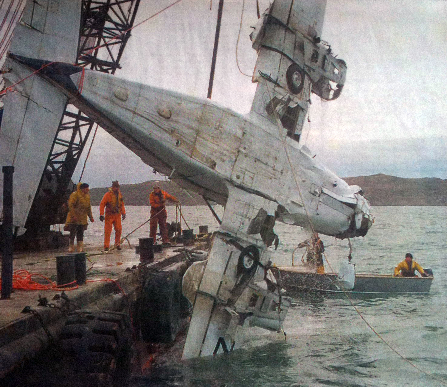
After completing the first run at the heavier weight, the pilot of ZK-EMV indicated to the loader driver that the load be increased by an additional hundredweight after the next run. The pilot of the second aircraft remained at 22 hundredweight, though he had moved his loading point back a short distance to provide additional take-off distance. The second pilot was still encountering “some sink” after take off, coinciding with the raising of flap. On completion of the second run at 22 hundredweight, the pilot of ZK-EMV positioned the aircraft for loading about 25 m to the east of his previous loading point. ZK-EMV was regarded by some personnel in the company to have had slightly better performance than other similar model aircraft. Consequently the increase to 23 hundredweight, while of interest, did not raise any concerns by the loader driver. Despite being unable to observe the departure of ZK-EMV, the loader driver was still able to hear the aircraft’s engine noise and recalled nothing unusual as the aircraft departed after loading. On returning from his run, the pilot of the second aircraft saw ZK-EMV to his lower right, in a steep climb, estimated to be about 45 to 50°. As it continued to climb the aircraft rolled slowly to the left, peaking at a height equivalent to “3 times power pole height”. Objects were seen falling from the aircraft during this time. Once inverted the aircraft descended rapidly, striking the ground. The aircraft hit the ground approximately 350 m from the strip, near where the power lines crossed a bend in the road and a small intersection. The pilot of the second aircraft landed and informed the two loader drivers. Together the group headed for the accident site in the loader truck. While en route a member of the group alerted emergency services by the use of a cellular telephone. The accident was also observed by the driver of a truck who had recently deposited a load of fertiliser in the bin at the airstrip. The driver had stopped the truck on a narrow gravel road below the airstrip to check the tailgate of the trailer. He then heard an aircraft begin its take-off run and decided to stay and watch the departure as the aircraft would fly over the road close to where the truck was parked. The driver saw ZK-EMV leave the end of the strip and “sag down a long way”, appearing to “drop like a stone”. The aircraft was observed to be in a high nose or climbing attitude as it continued to descend in a slight left turn towards a fence next to the road. The aircraft was then seen to strike the fence and balloon up, dropping fertiliser as it climbed. The aircraft then rolled left and descended in the direction of the truck driver, who quickly sought cover underneath the trailer. The aircraft struck the ground in a paddock next to the road, stopping about 5 m from the truck. With 15 years of working near agricultural aircraft, the truck driver considered himself to be familiar with their operations. The driver observed no items falling from the aircraft before it struck the fence, or anything hit the aircraft. He considered the engine to be at “full song” or maximum power the whole time and heard no change in pitch or beat. After the accident the truck driver went quickly to the upturned aircraft and attempted unsuccessfully to locate the pilot. The driver then headed for the airstrip in the truck, meeting the loader drivers and second pilot on their way to the aircraft. On reaching ZK-EMV the bucket on the loader was used to lift the aircraft to gain access to the cockpit. However, no assistance could be given to the pilot who had died on impact.
Probable cause:
The following findings were identified:
- The pilot was appropriately licensed, rated and experienced for the agricultural operation.
- The aircraft had a valid Certificate of Airworthiness and its records indicated that it had been maintained correctly.
- There was no evidence of any malfunction with the aircraft.
- The topography of the area should have presented no unusual problems for the pilot.
- The weather conditions at the time were suitable for sowing.
- A light tailwind component degraded the take-off and departure performance of the aircraft.
- Any ground effect benefits would have been lost immediately after take-off.
- The pilot was unable to establish a positive climb gradient after take-off.
- The aircraft was probably overweight for the prevailing variable weather conditions at the time of the last take-off.
- The pilot’s jettisoning of the load was too late to prevent the aircraft from striking the fence.
- As a result of striking the fence, the aircraft became uncontrollable.
Final Report:

Crash of a Britten-Norman BN-2A-26 Islander near Hoskins: 11 killed

Date & Time: Feb 3, 1999 at 1020 LT
Type of aircraft:
Operator:
Registration:
P2-ALH
Flight Phase:
Survivors:
No
Schedule:
Hoskins – Kandrian
MSN:
761
YOM:
1975
Region:
Crew on board:
1
Crew fatalities:
Pax on board:
10
Pax fatalities:
Other fatalities:
Total fatalities:
11
Circumstances:
Few minutes after takeoff from Hoskins, while cruising in poor weather conditions, the twin engine aircraft went out of control and crashed in a palm plantation located near Hoskins. The aircraft was destroyed and all 11 occupants were killed. At the time of the accident, weather conditions were poor with thunderstorm activity and severe turbulences. §
Probable cause:
It is believed that the aircraft suffered a structural failure due to severe turbulences while flying in bad weather conditions.

Crash of a Britten-Norman BN-2A-26 Islander off Cocos Islands: 3 killed

Date & Time: Jan 16, 1999 at 1430 LT
Type of aircraft:
Operator:
Registration:
VH-XFF
Survivors:
Yes
Schedule:
Horn Island - Cocos Islands
MSN:
763
YOM:
1975
Country:
Region:
Crew on board:
1
Crew fatalities:
Pax on board:
3
Pax fatalities:
Other fatalities:
Total fatalities:
3
Captain / Total flying hours:
2540
Captain / Total hours on type:
197.00
Aircraft flight cycles:
16775
Circumstances:
Uzu Air conducted passenger and freight operations between Horn Island and the island communities in the Torres Strait. It operated single-engine Cessna models 206 and 208 aircraft, and twin-engine Britten Norman Islander aircraft. On the morning of the accident, the pilot flew a company Cessna 206 aircraft from Horn Island to Yam, Coconut, and Badu Islands, and then returned to Horn Island. The total flight time was about 93 minutes. The pilot's schedule during the afternoon was to fly from Horn Island to Coconut, Yam, York, and Coconut Islands and then back to Horn Island, departing at 1330 eastern standard time. The flight was to be conducted in Islander, VH-XFF. Three passengers and about 130 kg freight were to be carried on the Horn Island - Coconut Island sector. Another company pilot had completed three flights in XFF earlier in the day for a total of 1.9 hours. He reported that the aircraft operated normally. Witnesses at Horn Island reported that the preparation for the flight, and the subsequent departure of the aircraft at 1350, proceeded normally. The pilot of another company aircraft heard the pilot of XFF report 15 NM SW of Coconut Island at 3,500 ft. A few minutes later, the pilot reported downwind for runway 27 at Coconut Island. Both transmissions sounded normal. Three members of the Coconut Island community reported that, at about 1410, they were on the beach at the eastern extremity of the island, about 250 m from the runway threshold and close to the extended runway centreline. Their recollections of the progress of the aircraft in the Coconut Island circuit are as follows: the aircraft joined the downwind leg and flew a left circuit for runway 27; the aircraft appeared to fly a normal approach until it passed over their position at an altitude of 200-300 ft; and it then veered left and commenced a shallow climb before suddenly rolling right and descending steeply onto a tidal flat, about 30 m seaward from the high-water mark, and about 200 m from their position. A passenger was seriously injured while three other occupants were killed.
Probable cause:
The following findings were identified:
- The pilot initiated a go-around from final approach because of a vehicle on the airstrip.
- The left propeller showed little evidence of rotation damage. The reason for a possible loss of left engine power could not be determined.
- For reasons that could not be established, the pilot lost control of the aircraft at a low height.
Final Report:

Crash of a Rockwell Shrike Commander 500S off Horn Island

Date & Time: Oct 21, 1998 at 0940 LT
Registration:
VH-YJT
Survivors:
Yes
Schedule:
Boigu Island - Horn Island
MSN:
500-3089
YOM:
1970
Country:
Region:
Crew on board:
1
Crew fatalities:
Pax on board:
4
Pax fatalities:
Other fatalities:
Total fatalities:
0
Captain / Total flying hours:
2045
Captain / Total hours on type:
79.00
Circumstances:
A Shrike Commander departed Horn Island on a charter flight to Saibai and Boigu Islands in accordance with the visual flight rules (VFR). The flight to Saibai took 32 minutes, and a further 13 minutes to Boigu Island. The aircraft then departed Boigu to return to Horn Island with an expected flight time of 35 minutes. The pilot reported that he had maintained 5,500 ft until commencing descent at 35 NM from Horn Island. He tracked to join final approach to runway 14 by 5 NM, reducing power at 1,500 ft. At 5 NM from the runway, the pilot extended the landing gear and approach flap and commenced a long final approach. When the aircraft was approximately 3 NM from the runway both engines commenced to surge, with the aircraft initially yawing to the right. The pilot commenced engine failure procedures and retracted the flaps. He tried a number of times to determine which engine was losing power by retarding the throttle for each engine, before deciding that the right engine was failing. The pilot shut down that engine and feathered the propeller. A short time later, when the aircraft was approximately 200 ft above the water, the left engine also lost power. The pilot established the aircraft in a glide, advised the passengers to prepare for a ditching, and transmitted a MAYDAY report on the flight service frequency before the aircraft contacted the sea. The aircraft quickly filled with water and settled on the seabed. All five occupants were able to escape and make their way ashore.
Probable cause:
The following findings were identified:
- The pilot was correctly licensed and qualified to operate the flight as a VFR charter operation.
- The aircraft was dispatched with an unusable fuel quantity indicator.
- The right engine fuel control unit was worn and allowed additional fuel through the system, increasing fuel consumption by approximately 6 L/hr.
- Inappropriate fuel consumption rates were used for flight planning.
- The aircraft fuel log contained inaccuracies that resulted in a substantial underestimation of the total fuel used.
- At the time of the occurrence, there was no useable fuel in the aircraft fuel system.
- Although the pilot met the Civil Aviation Safety Authority criteria to fulfil his role as chief pilot, he did not have the expertise to effectively ensure the safety of company flight operations.
Final Report:

Crash of a Cessna 402C off Halfmoon Bay: 5 killed

Date & Time: Aug 19, 1998 at 1643 LT
Type of aircraft:
Operator:
Registration:
ZK-VAC
Flight Phase:
Survivors:
Yes
Schedule:
Halfmoon Bay - Invercargill
MSN:
402C-0512
YOM:
1981
Country:
Region:
Crew on board:
1
Crew fatalities:
Pax on board:
9
Pax fatalities:
Other fatalities:
Total fatalities:
5
Captain / Total flying hours:
14564
Captain / Total hours on type:
27.00
Aircraft flight hours:
13472
Circumstances:
Surviving passengers reported that en route from Stewart Island to Invercargill there were symptoms of a righthand engine failure, which was corrected by the pilot's manipulation of floor-mounted fuel tank selectors. Shortly afterwards, both engines stopped. The pilot broadcast a Mayday and advised the passengers that they would be ditching. A successful ditching was carried out approximately 12 NM south of Invercargill. All occupants escaped from the aircraft, however, four persons exited without life jackets. The pilot entered the cabin but was unable to locate more before the aircraft sank. Rescuers reached the scene about an hour after the ditching only to find that all those without life jackets had perished, as had a young boy who was wearing one.
Probable cause:
A TAIC investigation found that there was no evidence of any component malfunction that could cause a double engine failure, although due to seawater damage the pre-impact condition of most fuel quantity system components could not be verified. Both fuel tank selectors were positioned to the lefthand tank, and it is probable that fuel starvation was the cause of the double engine failure. Company procedures for the Cessna 402 lacked a fuel quantity monitoring system to supplement fuel gauge indications. Dipping of the tanks was not a feasible option. Company pilots believed that the aircraft was fitted with low-fuel quantity warning lights, which was not the case. As three pilots believed the gauges indicated sufficient fuel was on board before the preceding round trip to the island, exhaustion may have followed an undetermined fuel indicating system malfunction. The failure of the company to require the use of operational flight logs, and other deficiencies in record keeping, were identified in the TAIC report. The much-publicised misunderstanding about the ditching location was not considered by the TAIC report to have affected the outcome of the rescue, but provides an example of the continued importance of using the phonetic alphabet in radiotelephony. A safety recommendation that operators use a fuel-quantity monitoring system to supplement fuel gauge indications was also made by the TAIC report.
Final Report:

Crash of a Partenavia P.68B in Wagga Wagga: 2 killed

Date & Time: Jul 20, 1998 at 1739 LT
Type of aircraft:
Registration:
VH-IXH
Flight Type:
Survivors:
No
Schedule:
Corowa – Albury – Wagga Wagga
MSN:
186
YOM:
1979
Country:
Region:
Crew on board:
1
Crew fatalities:
Pax on board:
1
Pax fatalities:
Other fatalities:
Total fatalities:
2
Captain / Total flying hours:
1014
Captain / Total hours on type:
217.00
Circumstances:
The aircraft operator had been contracted to provide a regular service transporting bank documents, medical pathology samples and items of general freight between Wagga Wagga, Albury and Corowa. On the day of the accident a passenger was accompanying the pilot for the day's flying. The pilot commenced the flight from Corowa to Albury under the Visual Flight Rules, flying approximately 500 ft above ground level. At Albury he obtained the latest aerodrome weather report for Wagga Wagga, which indicated that there was scattered cloud at 300 ft above ground level, broken cloud at 600 ft above ground level, visibility restricted to 2,000 m in light rain and a sea-level barometric pressure (QNH) of 1008 hPa. At 1715 Eastern Standard Time (EST) the aircraft departed Albury for Wagga Wagga under the Instrument Flight Rules. The pilot contacted the Melbourne en-route controller at 1728 and reported that he was maintaining 5,000 ft. Although the aircraft was operating outside controlled airspace, the en-route controller did have a radar surveillance capability and was providing the pilot with a flight information service. However, no return was recorded from the aircraft's transponder and at 1732 the pilot reported that he was transferring to the Wagga Wagga Mandatory Broadcast Zone frequency. This was the pilot's last contact with the controller. Although air traffic services do not monitor or record the Wagga Wagga Mandatory Broadcast Zone frequency, transmissions made on this frequency are recorded by AVDATA for the purpose of calculating aircraft landing charges. This information was reviewed following the accident. The pilot broadcast his position inbound to the aerodrome on the mandatory broadcast zone frequency and indicated that he was conducting a Global Positioning System (GPS) arrival. He established communication with the pilot of another inbound aircraft and at 9 NM from the aerodrome, broadcast his position as he descended through 2,900 ft. Approximately 1 minute and 20 seconds later, the pilot advised that he was passing 2,000 ft but immediately corrected this to state that he was maintaining 2,000 ft. He also stated that it was "getting pretty gloomy" and that according to the latest weather report he should be visual at the procedure's minimum descent altitude. The aircraft would have been approximately 6 NM from the aerodrome at this time. This was the last transmission heard from the pilot. The resident of a house to the south of Gregadoo Hill sighted the aircraft a short time before the accident. He was standing outside his house and stated that the aircraft was visible as it passed directly overhead at what appeared to be an unusually low height. The aircraft then disappeared into cloud that was obscuring Gregadoo Hill, approximately 350 m from where he was standing. Moments later he heard the sound of an impact followed almost immediately by a red flash of light. The noise from the engines appeared to be normal up until the sound of the impact. The aircraft had collided with steeply rising terrain on the southern face of Gregadoo Hill, approximately 40 ft below the crest. The hill is 4 NM from the aerodrome and is marked on instrument approach charts as a spot height elevation of 1,281 ft. The estimated time of the accident was 1739. The pilot and passenger sustained fatal injuries.
Probable cause:
The pilot had received an accurate appreciation of the weather conditions in the vicinity of Wagga Wagga prior to departing Albury. At that stage it would have been apparent that low cloud and poor visibility were likely to affect the aircraft's arrival. Under such conditions it would not have been possible to land from the GPS arrival procedure. As the reported cloud base and visibility were both below the minimum criteria, it is difficult to rationalise the pilot's transmission that, according to the latest weather report, he would be visual at the minimum descent altitude. This statement suggests that the pilot had already made the decision to continue his descent below the minimum altitude for the procedure and to attempt to establish visual reference for landing. Based on the report of broken low cloud in the vicinity of the aerodrome, the pilot would have needed to descend to 1,324 ft above mean sea level to establish the aircraft clear of cloud. This is within 50 ft of the last altitude recorded on the GPS receiver. Due to the difference between the actual and forecast QNH, the left altimeter would over-read by approximately 150 ft. At the time of the occurrence an otherwise correctly functioning instrument would have indicated an altitude of approximately 1,400 ft. The pilot had probably set the right altimeter to the local QNH prior to departing Albury. As this setting also corresponded to the actual QNH at Wagga Wagga, that instrument would have provided the more accurate indication of the aircraft's operating altitude. However, because of its location on the co-pilot's instrument panel, it is unlikely that the pilot would have included that altimeter in his basic instrument scan. It was not possible to assess the extent to which illicit drugs may have influenced the pilot's performance during the flight and affected his ability to safely operate the aircraft.
The following factors were identified:
- The pilot was operating the aircraft in instrument meteorological conditions below the approved minimum descent altitude.
- Low cloud was covering Gregadoo Hill at the time of the accident.
Final Report:

Crash of an Embraer EMB-110P1 Bandeirante in Hoskins

Date & Time: Mar 3, 1998
Operator:
Registration:
P2-ALY
Survivors:
Yes
MSN:
110-227
YOM:
1979
Region:
Crew on board:
3
Crew fatalities:
Pax on board:
10
Pax fatalities:
Other fatalities:
Total fatalities:
0
Circumstances:
After takeoff from Hoskins Airport, the stewardess informed the pilots about an explosion in the rear of the cabin. The crew returned to the airport for an emergency landing. After touchdown, the aircraft deviated to the left, veered off runway and came to rest in a ravine. All 13 occupants escaped uninjured while the aircraft was damaged beyond repair.

Crash of a Britten-Norman BN-2A-26 Islander in Sangafa-Siwo

Date & Time: Nov 27, 1997
Type of aircraft:
Operator:
Registration:
YJ-RV2
Survivors:
Yes
MSN:
172B
YOM:
1970
Country:
Region:
Crew on board:
1
Crew fatalities:
Pax on board:
2
Pax fatalities:
Other fatalities:
Total fatalities:
0
Circumstances:
The twin engine aircraft landed hard, went out of control, veered off runway and crashed in the sea. All three occupants were seriously injured and the aircraft was damaged beyond repair.

Crash of a Fokker F28 Friendship 1000 in Lae

Date & Time: Nov 16, 1997 at 1130 LT
Type of aircraft:
Operator:
Registration:
P2-ANH
Survivors:
Yes
Schedule:
Wewak - Madang
MSN:
11022
YOM:
1970
Flight number:
PX129
Region:
Crew on board:
4
Crew fatalities:
Pax on board:
45
Pax fatalities:
Other fatalities:
Total fatalities:
0
Circumstances:
The flight departed Wewak Airport at 1000LT on a flight to Madang. En route, a warning light came on in the cockpit panel, informing the crew about technical problems. The crew experienced difficulties with testing the lift dumper and wheel brake antiskid systems. The pilot decided to divert to Lae-Nadzab which offered a longer runway and fire fighting facilities. After touchdown, the left main gear collapsed. The crew lost control of the airplane that veered off runway to the left and came to rest in a ditch. All 49 occupants evacuated safely and the aircraft was damaged beyond repair.