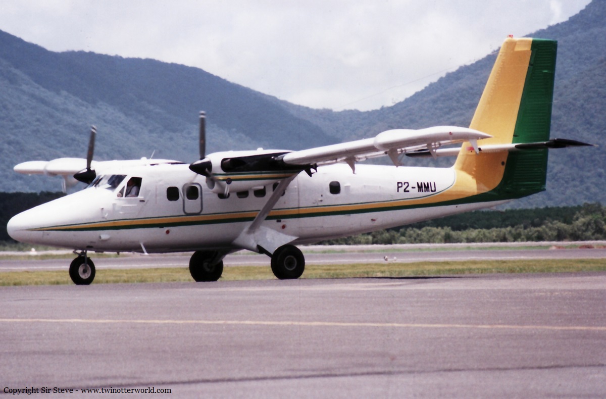
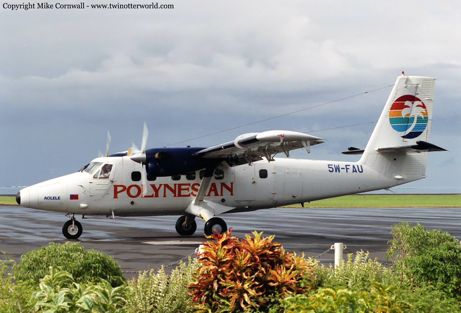
Crash of a De Havilland DHC-6 Twin Otter 300 near Simbai

Date & Time: Nov 9, 1997 at 1000 LT
Operator:
Registration:
VH-HPY
Flight Phase:
Flight Type:
Survivors:
Yes
Site:
Schedule:
Koinambe - Simbai
MSN:
706
YOM:
1980
Location:
Region:
Crew on board:
4
Crew fatalities:
Pax on board:
0
Pax fatalities:
Other fatalities:
Total fatalities:
0
Captain / Total flying hours:
2206
Captain / Total hours on type:
576.00
Copilot / Total flying hours:
2460
Copilot / Total hours on type:
900
Aircraft flight hours:
18096
Circumstances:
The flight was one of a series being conducted by No. 173 Surveillance Squadron, 1st Aviation Regiment operating a de Havilland Canada DHC-6 (Twin Otter) aircraft as Exercise Highland Pursuit 2/97. The purpose of the exercise was to provide training for three No. 173 Squadron pilots in tropical mountainous operations in Papua New Guinea (PNG). All trainees were qualified on the aircraft type. The training pilot was the pilot in command. He had extensive experience in flying Twin Otter and other aircraft types in PNG as a civilian pilot and had also flown de Havilland Canada DHC-4 (Caribou) aircraft in PNG as a military pilot. Passengers were not carried on the flight. The plan for 9 November 1997 was to fly from Madang and return via a number of airstrips where landing and take-off exercises would be conducted. A flight plan was submitted to Madang Flight Service. At 0915 PNG time, the aircraft arrived at Koinambe where each trainee conducted landing and take-off practice. During this time, the training pilot occupied the right cockpit seat while the trainees, in turn, flew the aircraft from the left cockpit seat. The crew had flight-planned to track direct from Koinambe to Simbai. However, before departing Koinambe, they assessed that this would not be possible because of haze and cloud on track. The training pilot, who was still occupying the right control position, suggested that they could follow the Jimi River north-west from Koinambe and then one of its tributaries towards Simbai. This involved a right turn off the Jimi River about 37 km from Koinambe to follow the valley that passed about 2 km south of Dusin airstrip and then tracked south-east towards Simbai. The navigating pilot, in the left cockpit seat, suggested that, instead of following the tributary off the Jimi River as suggested by the training pilot, they should follow the valley which extended north-east off the Jimi River from a position about 17 km north-west of Koinambe. This was a shorter route than that suggested by the training pilot. The training pilot agreed that the route could be attempted. Neither during this discussion, nor at any earlier time, was there any reference to the elevation of the Bismarck Range. (The increase in ground elevation from the Jimi River to the Bismarck Range, a straight-line distance of about 17 km, is approximately 7,400 ft.) The crew was using an Operational Navigation Chart (ONC) 1:1,000,000-scale chart for in-flight navigation. After departing Koinambe, the crew began following the Jimi River, flying at about 1,000 ft above ground level (AGL). The training pilot had intended to remain in the right cockpit seat for the short flight to Simbai. However, to gain the maximum benefit from flying time during the exercise, he had adopted the practice of having trainees occupy both cockpit seats during the en-route sectors of the exercise. He would then monitor the progress of the flight from either between the cockpit seats or the aircraft cabin. In this instance, he vacated the right seat for a trainee who then became the flying pilot for the sector. The navigating pilot then made the required radio calls, one on VHF radio and the other (which was unsuccessful at the first attempt) on HF radio to Madang Flight Service to report the departure of the aircraft from Koinambe. A short time later, the navigating pilot became unsure of the aircraft's position. The flying pilot then conducted several left orbits while the navigating pilot obtained a Global Positioning System (GPS) fix and plotted the position on the ONC chart. He indicated on the chart, and received agreement from the training pilot, that he had identified the aircraft's position. The flying pilot then resumed tracking along the river. During this time the training pilot was in the cabin of the aircraft. He was wearing a headset which was equipped with an extension lead to enable him to communicate with the cockpit crew. He was frequently checking the aircraft's position through the cabin side windows. A short time later, the navigating pilot indicated what he believed to be the valley where the aircraft was to turn towards Simbai. The flying pilot turned the aircraft into this valley. He estimated that the aircraft was flying about 500 ft above the treetops at this time. The crew did not conduct a heading check to confirm that they were in the correct valley. When the aircraft was well into the valley, the training pilot heard over the intercom the flying and navigating pilots discussing the progress of the flight. He sensed some unease in their voices and moved forward from the aircraft cabin to a position between the cockpit seats. He immediately realised that the aircraft was at an excessive nose-high pitch angle and in a position from where it could not outclimb the terrain ahead or turn and fly out of the valley. The flying and navigating pilots ensured that the engine and propeller controls were set to full power and maximum RPM and selected 10 degrees flap. However, the training pilot assessed that impact with the trees was imminent. He ensured that the trainee seated in the cabin was strapped into his seat and then positioned himself on the floor aft of, and against, the cabin bulkhead. The stall warning activated at that time and, almost immediately, the aircraft crashed through the trees to the ground. When the crew had not reported to flight service by 1004, communication checks were initiated. An uncertainty phase was declared at 1023 when there was no contact with the crew. At 1045, this was upgraded to a distress phase after the pilot of a helicopter operating in the area reported that the aircraft was not on the ground at Simbai airstrip. The pilot of the helicopter was tasked with tracking from Simbai to Koinambe in an attempt to locate the aircraft. At 1127, the helicopter pilot reported receiving a strong emergency locator transmitter signal and, shortly after, located the accident site in a valley about 9 km south of Simbai.
Probable cause:
The following factors were identified:
1. There had been a significant loss of corporate knowledge, experience and risk appreciation within the Army concerning the operation of Twin Otter type aircraft in tropical mountainous areas.
2. No training needs analysis for the exercise had been conducted.
3. The tasking and briefing of the training pilot were incomplete.
4 The training pilot did not adequately assess the skill development needs of the trainees.
5. The supervision of the flight by the training pilot was inadequate.
6. The scale of chart used by the crew was not appropriate for the route they intended to fly.
Final Report:

Crash of a Fletcher FU-24-950 in Fairlie

Date & Time: Aug 30, 1997 at 0730 LT
Type of aircraft:
Registration:
ZK-DIL
Flight Phase:
Survivors:
Yes
MSN:
175
YOM:
1972
Country:
Region:
Crew on board:
1
Crew fatalities:
Pax on board:
0
Pax fatalities:
Other fatalities:
Total fatalities:
0
Circumstances:
While turning onto the sowing run, at about 300 feet agl, a significant downdraught was encountered, together with a loss of at least 5 knots airspeed. The pilot responded by pushing the control column aggressively forward and turning towards the lower ground. At the same time, he operated the jettison lever. The rate of dump and the recovery from the downdraught were far less than anticipated, and the pilot found himself about to collide with rocks in a paddock. He pulled hard back, but was unable to avoid hitting the ground with the left wing. The aircraft flipped and slid backwards to a halt. The pilot's instructor was operating a second Fletcher on the same job, saw that there had been a crash, and, after jettisoning his own load, landed nearby and went to the pilot's assistance. Meteorological conditions were favourable for topdressing, but katabatic winds were likely to have been present in the valley, after a clear, cool night. By the time of these flights, a light northwesterly was in place, which could have added to a katabatic flow. There was very light turbulence. Shortly after the accident, light wind gusts were noted; a steady, stronger wind down the valley was established by mid morning. The accident pilot's training had been completed only the day before, and foremost in his mind was the need to avoid a stall. The combination of pushing forward more than necessary, and a turning flight-path, made the jettison ineffective. In the pull-up to avoid hitting the ground the jettison rate increased, but about one third of the load remained aboard after the accident. It was recommended, and accepted, that the pilot receive more dual training on the stall characteristics of the aircraft, with an emphasis on the speed margins available when manoeuvring at low speed. The agricultural operators association was to be asked to remind members of the effect of manoeuvring on jettison characteristics.

Crash of a De Havilland DHC-6 Twin Otter 300 in Goroka: 2 killed

Date & Time: Jul 18, 1997 at 1032 LT
Registration:
P2-MMU
Survivors:
Yes
Site:
Schedule:
Port Moresby - Mount Hagen - Chimbu - Goroka
MSN:
250
YOM:
1969
Region:
Crew on board:
2
Crew fatalities:
Pax on board:
2
Pax fatalities:
Other fatalities:
Total fatalities:
2
Circumstances:
En route from Chimbu to Goroka, the crew encountered poor weather conditions with rain falls and fog. Other crew diverted to Madang Airport but the crew decided to continue. While flying at an altitude of 7,400 feet in limited visibility, the aircraft struck the slope of Mt Yasirua located 7,2 km northeast of Goroka Airport. A pilot and a passenger survived while both other occupants were killed.
Probable cause:
Controlled flight into terrain.

Crash of a Fletcher FU-24-950 in Dannevirke

Date & Time: Feb 25, 1997 at 0926 LT
Type of aircraft:
Registration:
ZK-DZF
Flight Phase:
Survivors:
Yes
MSN:
206
YOM:
1975
Country:
Region:
Crew on board:
1
Crew fatalities:
Pax on board:
0
Pax fatalities:
Other fatalities:
Total fatalities:
0
Circumstances:
The topdressing operation had resumed after a break caused by weather deterioration associated with a weakening frontal system in the immediate area. Mist and low cloud had cleared, and the wind had picked up. The pilot was sowing into a narrow, rising valley. It was the sixth run over the same terrain, after an increase in payload. The pilot initially encountered lift then heavy sink. Unable to reverse course within the confines of the narrow valley, and despite the application of full power, 20 degrees of flap and an attempt to dump the payload, he failed to establish a climb. The aircraft stalled in a lefthand turn and impacted the valley side. The aircraft struck left wing first, removing the outer wing section. It then hit the ground flat but turning anti-clockwise and skidded tail first to a halt. The hopper mouth was torn loose, and this and the nose leg disrupted the cockpit floor, trapping the pilot's legs within the cockpit area and inflicting serious injuries. The pilot was wearing full restraint harness and a protective helmet, which undoubtedly saved him from further injury. He suffered some post-impact disorientation, but fortunately there was no post-crash fire. The Police and Fire Services in attendance were unaware of the actions required to secure the aircraft fuel and electrical systems.

Crash of a Fletcher FU-24-954 near Taihape: 1 killed

Date & Time: Jan 22, 1997 at 0800 LT
Type of aircraft:
Operator:
Registration:
ZK-EHX
Flight Phase:
Survivors:
No
MSN:
262
YOM:
1979
Country:
Region:
Crew on board:
1
Crew fatalities:
Pax on board:
0
Pax fatalities:
Other fatalities:
Total fatalities:
1
Circumstances:
The pilot was conducting a topdressing operation in hilly terrain in fine weather. He had stopped sowing and commenced a right hand turn. Considerable height was lost in the turn for reasons undetermined. The aircraft impacted with terrain under power in a 60° banked, 30° nose down attitude. The aircraft was totally destroyed in the impact and post crash fire, the pilot receiving fatal injuries. No technical deficiencies were revealed.
Probable cause:
The exact cause of the accident could not be determined.

Crash of a De Havilland DHC-6 Twin Otter 300 in Apia: 3 killed

Date & Time: Jan 7, 1997 at 1038 LT
Operator:
Registration:
5W-FAU
Survivors:
Yes
Site:
Schedule:
Pago Pago - Apia
MSN:
678
YOM:
1980
Flight number:
PH211
Region:
Crew on board:
2
Crew fatalities:
Pax on board:
3
Pax fatalities:
Other fatalities:
Total fatalities:
3
Circumstances:
At about 1038 hours on Tuesday 7 January 1997, Polynesian Airlines’ DHC-6 (Twin Otter) 5W FAU collided with the western slopes of Mt Vaea, Apia, in conditions of low cloud and heavy rain. The aeroplane was on a scheduled flight from Pago Pago to Fagali’i, and was being flown to Fagali’i by visual reference after having made an instrument approach to Faleolo. The captain and two passengers lost their lives in the accident. The first officer and one passenger survived.
Probable cause:
The following causal factors were identified:
• The decision by the captain to continue the flight toward Fagali’i in reduced visibility and subsequently in cloud.
• Mis-identification of ground features, or an inappropriate heading and altitude flown, as a result of inadequate visual reference.
• Insufficient forward visibility to ensure effective and timely action to avoid a collision with terrain.

Crash of a Lockheed PV-1 Ventura in Richmond

Date & Time: Nov 18, 1996 at 1335 LT
Type of aircraft:
Operator:
Registration:
VH-SFF
Flight Type:
Survivors:
Yes
Schedule:
Richmond - Richmond
MSN:
5378
YOM:
1943
Country:
Region:
Crew on board:
0
Crew fatalities:
Pax on board:
0
Pax fatalities:
Other fatalities:
Total fatalities:
0
Captain / Total flying hours:
11444
Captain / Total hours on type:
25.00
Circumstances:
The aircraft was approaching to land after completing a handling display during an Open Day at RAAF Richmond. At an altitude of about 800 feet, on the base leg for runway 28, both engines stopped simultaneously and without warning. As there was insufficient altitude to reach the field for a power off landing, the flaps and landing gear were retracted and a successful forced landing carried out into a cleared field short of the airfield. The crew evacuated the aircraft without injury.
Probable cause:
A subsequent investigation failed to positively determine the cause of the simultaneous stoppage of both engines. A large quantity of fuel remained in the tanks and no defects were found with either of the engine fuel systems. The engine ignition systems were tested and functioned normally after the accident. The design of this aircraft, as with other ex-military multi-reciprocating engine types, includes a master ignition switch. The switch is guarded, and when turned off results in the termination of ignition to all engines simultaneously. The switch was removed from the aircraft after the accident and subjected to extensive testing, including vibration tests, but could not be faulted. It was noted however that ignition isolation resulted with only a small movement of the switch from the ON position. The most likely reason for the sudden stoppage of both engines was movement of the master ignition switch from the ON position, possibly as the result of vibration or by a crew member inadvertently bumping the switch prior to landing.
Final Report:

Crash of a De Havilland DHC-2 Beaver in Point Lookout: 1 killed

Date & Time: Nov 15, 1996 at 1300 LT
Type of aircraft:
Operator:
Registration:
VH-IDI
Flight Phase:
Survivors:
No
Schedule:
Kotupna - Kotupna
MSN:
1535
YOM:
1963
Country:
Region:
Crew on board:
1
Crew fatalities:
Pax on board:
0
Pax fatalities:
Other fatalities:
Total fatalities:
1
Captain / Total flying hours:
1400
Captain / Total hours on type:
200.00
Circumstances:
On the morning of the accident, the pilot and the loader-driver left Armidale in the aircraft between 0715 and 0730 and flew to the property "KOTUPNA". The task required the aircraft to operate from an agricultural strip 4,400 ft above mean sea level. Superphosphate spreading operations commenced between 0745 and 0800 and continued for approximately 1.5 hours after which the pilot and driver refuelled the aircraft and had a break. The pilot remarked to the driver that the aircraft was going very well and requested him to load a tonne of superphosphate. Operations resumed for about 1.5 hours and then ceased again whilst the aircraft was refuelled. After refuelling, the driver and the pilot had lunch and a break for about half an hour. The pilot again advised the loader driver that he would take a tonne, as the aircraft was performing well. After warming up the engine, the pilot made a normal take-off in a northeasterly direction and banked to the left to head southwest to the treatment area. The driver observed that the aircraft was lower and closer into the strip than had been the normal route to the treatment area. The aircraft did not seem to be climbing sufficiently to pass over the hill in front of it. The aircraft was then seen to be in a climbing left turn, toward the driver with superphosphate dumping from it. The aircraft's left wingtip contacted the ground after which the aircraft cartwheeled and came to rest 200-300 meters from the superphosphate dump. The driver ran down to the aircraft and found the pilot still strapped in the seat with no apparent sign of life. He moved the pilot clear of the aircraft in case of fire and then summoned help.
Probable cause:
The following factors were reported:
- Wind conditions, which were conducive to windshear and turbulence, were present in the area.
- The aircraft was climbing at near maximum weight.
- The aircraft was climbing into rising ground.
- The aircraft was operating at a high-density altitude, which would have placed it near its performance limit.
- Control of the aircraft was lost with insufficient height to effect recovery.
Final Report:

Crash of a Fletcher FU-24-A4 near Dunedoo: 1 killed

Date & Time: Oct 30, 1996 at 1000 LT
Type of aircraft:
Operator:
Registration:
VH-BBG
Flight Phase:
Survivors:
No
Schedule:
Dunedoo - Dunedoo
MSN:
141
YOM:
1968
Country:
Region:
Crew on board:
1
Crew fatalities:
Pax on board:
0
Pax fatalities:
Other fatalities:
Total fatalities:
1
Captain / Total flying hours:
7200
Captain / Total hours on type:
28.00
Circumstances:
The pilot had arrived at the property to commence spraying operations on the day before the accident, and had been provided with a map of the area by the property owner. In addition, the property owner briefed the pilot on the location of relevant powerlines and other obstructions. However, the pilot did not carry out any spraying on that day, but instead flew the aircraft to Scone, in order to have a minor engine problem rectified. He then flew to Mudgee where the aircraft remained overnight. The pilot returned to the area the next morning, arriving on site at about 0645 ESuT. After spraying approximately 175 acres on an adjoining farm, he commenced an aerial inspection of the next property to be treated, but declined an offer by the property owner to accompany him in the aircraft so the property boundaries and powerlines could be pointed out. The aircraft was seen to make three passes over the area before it descended in an easterly direction, toward a crop of barley. A gentle rise, which included a dam bank located at the corner of the crop, had to be negotiated in order for the pilot to position the aircraft at the correct operating height for the swath run. A spurline, suspended over the crop and running in a northerly direction, was located a further 40 m beyond the dam. A witness reported that the aircraft had appeared to be maintaining level flight, and had commenced spraying, when it struck the spurline, then impacted heavily with the ground and overturned, fatally injuring the pilot. The weather in the area at the time of the accident was reported as fine, with light winds. The aircraft struck a three-wire spurline which ran in a northerly direction over the crop, at right angles to its flight path. The line spanned 165 m from the main powerline to the first spurline pole, located about 100 m from a house and to the left of the flight path. A number of large trees nearer to the house provided a backdrop to the spurline pole. A strainer wire stemming from the main powerline was positioned some 92 m further on in the direction of the intended flight path. It was about 10 m in length and ran parallel to the spurline. The strainer wire passed over a road and was attached to a support pole located one metre from the edge of the barley crop. The pilot had commenced the first swathe run by flying in an easterly direction, towards distant rising ground which was cloaked in shadow, whilst the powerline in the foreground was set against this backdrop.
Probable cause:
The following factors were reported:
1. The pilot had limited recent flying experience.
2. The pilot had limited experience on the aircraft type, particularly with regard to low-level spraying operations, prior to the accident.
3. The performance of the pilot may have been impared by the effects of a medical condition he was suffering from.
4. The location of the spurline was difficult to see and may have been confused with an apparent powerline, further along the intended flight path.
5. The aircraft was not fitted with any form of wire deflector or cutter.
6. The aircraft provided limited structural rollover protection for the pilot during the accident sequence.
Final Report:

Crash of a Britten-Norman BN-2A-21 Islander in Ngau

Date & Time: Sep 23, 1996
Type of aircraft:
Registration:
DQ-FIF
Survivors:
Yes
Schedule:
Suva - Ngau
MSN:
417
YOM:
1974
Country:
Region:
Crew on board:
2
Crew fatalities:
Pax on board:
3
Pax fatalities:
Other fatalities:
Total fatalities:
0
Circumstances:
The approach and landing to Ngau Airport were completed in poor weather conditions with fog and rain falls. After landing on a wet grassy runway, the aircraft was unable to stop within the remaining distance (the runway is 760 metres long). It overran, lost its undercarriage and came to rest few dozen metres further. All five occupants escaped injured and the aircraft was damaged beyond repair.
Probable cause:
Wrong approach configuration on part of the crew who completed the landing at an excessive speed on a wet and short grassy runway.