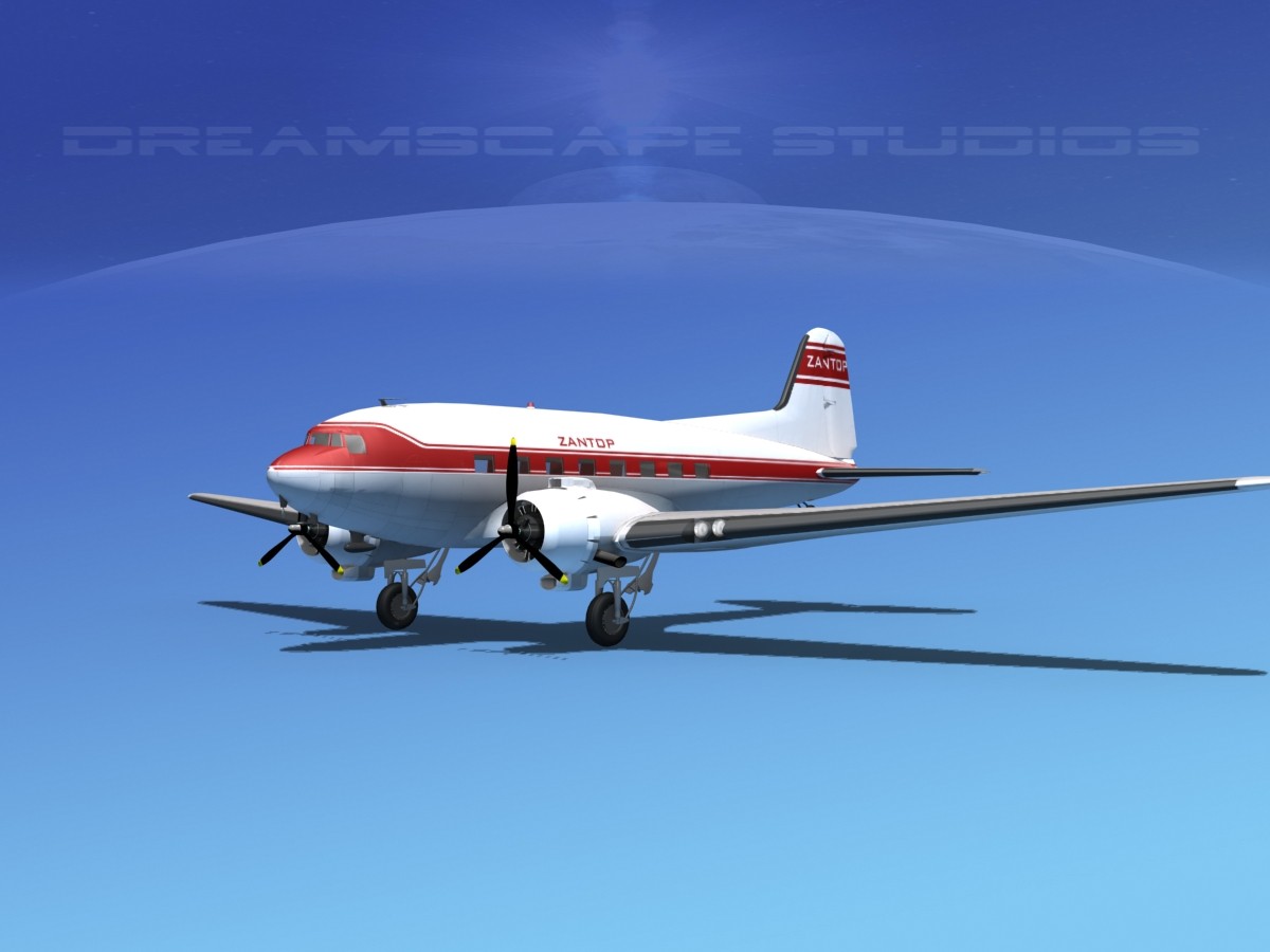
Crash of a Convair CV-240-0 in Buffalo

Date & Time:
Type of aircraft:
Operator:
Registration:
N94244
Flight Phase:
Survivors:
Yes
Schedule:
Buffalo – Saint Louis
MSN:
88
YOM:
1948
Flight number:
AA767
Crew on board:
3
Crew fatalities:
Pax on board:
21
Pax fatalities:
Other fatalities:
Total fatalities:
0
Captain / Total flying hours:
8671
Captain / Total hours on type:
4389.00
Copilot / Total flying hours:
4249
Copilot / Total hours on type:
2082
Aircraft flight hours:
11018
Circumstances:
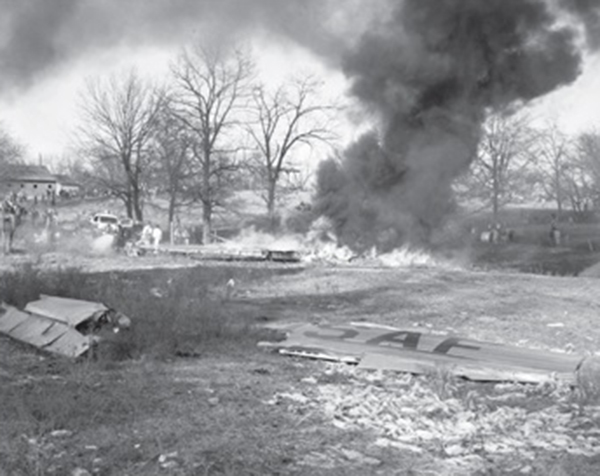
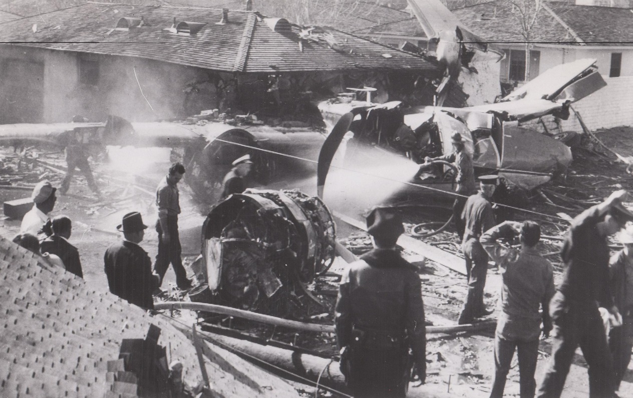
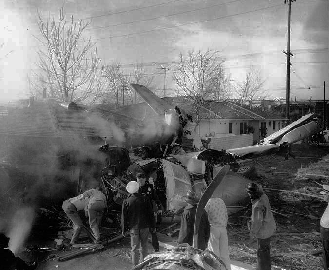
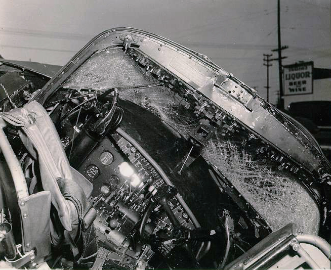
While taxiing to Runway 23 the flight received an IFR (Instrument Plight Rules) clearance from ARTC (Air Route Traffic Control). Normal pre-takeoff checks were performed and the takeoff roll was started at 1640. The aircraft became airborne after using approximately one-half of the 5.630-foot runway. Immediately after leaving the ground the gear was raised and the first officer saw the left feathering button light come on dimly which indicated that the left propeller was in the process of being feathered by the auto-feathering system. After definitely determining the light was on and visually checking the left propeller, the auto-feathering system was disarmed and the captain., in an effort to stop the feathering cycle, pulled the feathering button to neutral. This effort was unsuccessful. the left propeller feathered, and the engine stopped. During the climb an air speed of 140 m.p.h. was reached and maintained., the right engine remaining at full takeoff power. Approximately 250 feet above the ground a shallow left turn was started and the first officer was ordered to reinstate the left engine. the captain believing the aircraft would climb no farther. In the effort to restart the left engine by unfeathering the left propeller. only 600 r.p.m. could be obtained and the captain felt a buffeting through the control yoke. The aircraft at this time had progressed in the left turn approximately 180 degrees from the takeoff direction and the captain. fearing he would be unable to clear obstructions. Including high tension lines, decided to make a wheels-up landing. The landing was made in a field approximately one mile south of the airport. When the aircraft stopped, the passengers and crew evacuated it in an expeditious and orderly manner. The airplane was damaged beyond repair.
Probable cause:
The Board determines that the probable cause of this accident was (1) a mechanical failure of the torquemeter boost pump that automatically feathered the left propeller immediately after becoming airborne., and (2) the use of an incorrect procedure for unfeathering which resulted from the ambiguity of the instruction for unfeathering contained in the company's manual. The following findings were reported:
- Immediately after takeoff the left propeller automatically feathered due to a mechanical failure of the torquemeter boost pump,
- The engine stopped as a result of the feathering and was capable of being restarted,
- The procedure used to unfeather the propeller and reach starting r.p.m. was incorrect due to an ambiguity of the unfeathering instructions outlined in the flight manual,
- The first officer did not reinstate the mixture control to "auto-rich" because starting r.p.m. was not reached,
- The windmilling propeller drag. the existing weather and the banked attitude of the aircraft caused it to lose altitude,
- A forced landing was made one mile south of the Buffalo Airport shortly after becoming airborne.
Final Report:

Crash of a Douglas DC-3A in Kansas City: 3 killed

Date & Time:
Type of aircraft:
Operator:
Registration:
N49551
Flight Type:
Survivors:
No
Schedule:
Jackson – Kansas City – Atlanta
MSN:
4940
YOM:
1942
Flight number:
VK040
Crew on board:
3
Crew fatalities:
Pax on board:
0
Pax fatalities:
Other fatalities:
Total fatalities:
3
Captain / Total flying hours:
5333
Captain / Total hours on type:
2091.00
Copilot / Total flying hours:
5337
Copilot / Total hours on type:
1120
Aircraft flight hours:
24786
Circumstances:
The airplane departed Jackson, Michigan, for Atlanta, Georgia, with a planned intermediate stop to discharge cargo at Fairfax Airport, Kansas City, Kansas. This was a cargo flight designated as Trip 40-2011; the crew consisted of Captain William D. Speaks, Pilot in command, Captain Edward F. Kaselak and First officer Byron R. Williams. Prior to departing Jackson, the crew went to the CAA communications Station on the airport and reviewed the weather sequence reports and en route forecast and Captain Speaks also telephoned the U.S. Weather Bureau office at Detroit, Michigan, to obtain more detailed information. Following the review of the weather data, an IFR (instrument Flight Rules) flight plan to Kansas City, Kansas, was filed which indicated a cruising altitude of 10,000 feet, estimated elapsed time of four hour plus 20 minutes with seven hours of fuel on board and Springfield, Missouri, as the alternate airport, According to company records, the weight of the aircraft at takeoff was under the allowable gross weight of 26,900 pounds and the load was distributed so that the center of gravity of the aircraft was within approved limits. Routine position reports were made and when over Burlington, Iowa, at 0536, the flight was cleared to the Liberty Non-Directional Beacon, 16 miles northeast of Kansas City, to descend to and maintain 2,500 feet. At 0627, ARTC (Air Route Traffic Control) cleared the flight to the Kansas City, Missouri ILS (Instrument Landing System) outer marker to maintain 2,500 feet and to contact approach control when over Liberty. Twenty-nine minutes later, at 0656, the flight reported being over Liberty and approach control gave it the 0635 Kansas City, Missouri weather as follows: ceiling measured 600 feet, overcast, visibility 1-1/2 miles, light freezing drizzle, fog, and altimeter setting 29, 89. At this time approach control also verified that the aircraft was to land at the Fairfax Airport, Kansas City, Kansas, and immediately gave it the 0655 Fairfax Airport weather report: ceiling measured 600 feet, overcast, visibility 2 miles, light freezing drizzle, light snow fog and wind northwest 30 m.p.h. This airport is one and one-half miles northwest of the Kansas City Municipal Airport and across the Missouri River. The flight was then cleared to make an ADF approach to Fairfax for a landing on Runway 31 and was requested to report leaving the outer marker. N 49551 reported leaving the outer marker inbound at 0705 and was advised to contact the Fairfax Tower, The flight complied and requested the wind direction and runway in use. The tower replied that the runway was 31, the wind was from the north-northwest 20-30 m.p.h. and gusty, and the altimeter setting was 29.88. A few seconds later the tower also advised that the high intensity approach lights at the Kansas City Municipal Airport were on and if too bright, would be turned down. The flight's acknowledgement was negative and there was no further radio contact. At approximately 0775 the wreckage was located by the Kansas City Municipal Airport Patrol 400 feet north and 156 feet west of the approach and of Runway 17 of that airport.
Probable cause:
The Board determines that the probable cause of this accident was the loss of control of the aircraft at an altitude too low to effect recovery, which loss of control resulted from an accumulation of ice and the use of deicer boots at low air speeds. The following findings were reported:
- The ceiling at the Fairfax Airport during the approach was 100 feet lower than CAA prescribed minimums,
- While attempting a circling approach to Runway 31 the flight encountered conditions of restricted visibility,
- The aircraft had accumulated ice during the approach and descent in sufficient quantity to adversely affect control,
- Deicer boots were operating during the approach thereby increasing the stalling speed.
Final Report:

Crash of a Douglas A-26C-45-DT Invader in Donelson: 3 killed

Date & Time:
Type of aircraft:
Operator:
Registration:
44-35757
Flight Type:
Survivors:
No
Schedule:
Shaw - Sewart
MSN:
29036
YOM:
1944
Crew on board:
3
Crew fatalities:
Pax on board:
0
Pax fatalities:
Other fatalities:
Total fatalities:
3
Circumstances:
The crew was returning to Sewart AFB in Smyrna following a mission at Shaw AFB, South Carolina. While approaching from the north in marginal weather conditions, the airplane went out of control, dove into the ground and crashed onto a house located in Donelson, about a mile north of the Nashville International Airport. The airplane and the house were destroyed by fire and all three crew members were killed. A person in the house was injured. At the time of the accident, the cloud base was at 1,100 feet with icing conditions.

Crash of a Grumman G-73 Mallard near Shreveport: 12 killed

Date & Time:
Type of aircraft:
Registration:
N4949N
Flight Type:
Survivors:
No
Schedule:
Lower Mud Lake - Shreveport
MSN:
J-16
YOM:
1947
Crew on board:
2
Crew fatalities:
Pax on board:
10
Pax fatalities:
Other fatalities:
Total fatalities:
12
Captain / Total flying hours:
6852
Captain / Total hours on type:
1114.00
Copilot / Total flying hours:
3144
Copilot / Total hours on type:
1020
Aircraft flight hours:
1730
Circumstances:
This flight was for the purpose of transporting 10 men from a private duck hunting camp at Lower Mud Lake, Louisiana, near the mouth of the Mermentau River, to Shreveport, Louisiana, about 190 miles north-northwest. There were ten in the hunting party; the other four and baggage for all 14 were flown to Shreveport in another company airplane from the Lake Charles, Louisiana Airport some 30 miles from Lower Mud Lake. At the time of takeoff, weather over the route was overcast with the base of clouds at 800 or 900 feet, and tops sloping from about 2,500 feet at Lower Mud Lake to 7,000 feet at Shreveport. The 1628 weather at Lake Charles Airport, 160 miles from Shreveport, and on course, was: measured ceiling 900 feet, overcast; visibility 10 miles; temperature 47 degrees; dew point 44; wind northeast 17; altimeter 29.92. The gross weight at takeoff was approximately the prescribed maximum of 12,750 pounds; the C. G. was located within prescribed limits. The pilot was W. C. Huddleston, the copilot L. R. Schexnaydre. Takeoff was made at about 1635 from Lower Mud Lake. The aircraft first reported at 1704 to the CAA Alexandria radio station, giving its position as on top (of clouds) over DeRidder, Louisiana, approximately 76 miles from the point of departure and on course. At this time the pilot requested and received Shreveport weather: measured ceiling 600 feet, variable, overcast; visibility 2 miles: drizzle, fog; temperature 36; dew point 34; wind west-northwest 17; altimeter 30.02; ceiling variable 400 to 800 feet. Alexandria radio also advised that it was very possible the drizzle would turn into freezing drizzle because of low temperature in the Shreveport area. The pilot acknowledged and said that he was going to fly on top to Elmgrove, a fan marker about 16 miles southeast of Shreveport, then file an instrument let-down to Shreveport. He then reported that he was in the clear and cloud tops were at 4,500 to 5,000 feet. At 1719 the flight reported to Shreveport Approach Control as being 30 miles southwest of Natchitoches, Louisiana, about 70 miles from Shreveport, altitude 5,500 feet, 500 on top, inbound to Shreveport, and asked for an Instrument Flight Rules clearance for approach. The flight was then issued a 500-feet-on-top clearance to Shreveport Instrument Landing System outer marker, and the pilot replied that he was estimating the outer marker at 1750. At approximately 1729 Approach Control again checked with Fort Worth Air Route Traffic Control to ascertain if any traffic in the vicinity would prevent descent from 500 feet on top to 2,000 feet, with a new clearance to Forbing, Louisiana, a range intersection about 10 miles southwest of the Shreveport Airport. ARTC advised that if the aircraft was above 5,000 feet to start it down immediately. Approach Control then asked the pilot has altitude; he replied that he was now at 6,000 feet, more than 500 feet on top. Approach Control then cleared him to descend to 2,000 feet, maintaining 2,000 feet to Forbing, with no delay expected, to report leaving the 6,000-foot altitude and when passing 5,000 feet, and to start descent immediately. The flight was then advised of reported icing at 4,000 feet and above and given the 1704 Shreveport weather: 300 feet scattered, measured 600 variable, overcast, 2 miles visibility, light snow and fog. This was acknowledged. The flight left 6,000 feet at 1730 and 5,000 feet at 1732 reporting temperatures of 40 degrees F. and 32 degrees F., respectively. At 1745 the flight advised that it was at 2,000 feet and had picked up a "load" of ice. It was cleared to 1,500 feet, the minimum safe altitude, at which time the pilot said he was on the back course of the localiser. The flight was then requested to report when passing the localiser upon winch Approach Control would bring it in. The pilot requested the ground temperature, which was given as 34 degrees F. The next contact advised being at 1,200 feet which was all he "could hold." At 1747 the flight was cleared for an approach and was asked for an arrival estimate at the outer marker. At 1749, the last radio contact with the flight, it reported being contact below the clouds with Wallace Lake in sight and "going in." No emergency, as such, was declared. Several persons near the crash site heard the engines and then saw the aircraft just below the overcast some 400 to 500 feet above the ground. It descended steeply, banking sharply from side to side several times with very loud but normal engine noise. It passed from view beyond trees; almost immediately a crash was heard and a glare seen.
Probable cause:
The Board determines that the probable cause of this accident was the rapid accumulation of wing ice to such a degree that the aircraft could not maintain altitude. A contributing factor was the pilot's failure to acquaint himself with the pertinent weather forecasts. The following findings were reported:
- The aircraft did not have wing or windshield deicing equipment,
- The US Weather Bureau area forecast for the time and place of the accident included occasional severe icing,
- The pilot did not obtain sufficient weather information to conduct this flight safely,
- The aircraft quickly acquired so much ice that it could no longer maintain altitude.
Final Report:

Crash of a North American TB-25J Mitchell in Cowpens: 3 killed

Date & Time:
Operator:
Registration:
44-30496
Flight Phase:
Flight Type:
Survivors:
No
Schedule:
Griffiss - Donaldson
MSN:
108-33771
YOM:
1944
Crew on board:
3
Crew fatalities:
Pax on board:
0
Pax fatalities:
Other fatalities:
Total fatalities:
3
Circumstances:
The crew left Griffiss AFB in Rome, New York, at 1330LT on a routine flight to Donaldson AFB, Greenville, South Carolina. While descending to Greenville, the pilot encountered foggy conditions when the airplane hit trees and lost its tail before crashing in a wooded area located in Cowpens, about 35 miles northeast of Donaldson AFB. The airplane was totally destroyed by impact forces and a post crash fire and the tail was found about a mile away from the main wreckage. It was reported that the crew encountered difficulties shortly before the accident.
Crew:
Col Paul C. Schauer, pilot,
Maj Russell Kraus, copilot,
A1c Frederick W. Walker, flight engineer.

Crash of a Douglas A-26B Invader in Glendale: 1 killed

Date & Time:
Type of aircraft:
Registration:
N65Y
Flight Phase:
Flight Type:
Survivors:
Yes
MSN:
7240
YOM:
1941
Crew on board:
2
Crew fatalities:
Pax on board:
0
Pax fatalities:
Other fatalities:
Total fatalities:
1
Circumstances:
Shortly after takeoff from Glendale Airport, while in initial climb, the airplane encountered difficulties to gain height. It struck power cables and crashed onto houses near the airport. While both crew members were injured, one person on the ground was killed.
Final Report:

Crash of a Lockheed C-60A-1-LO LodeStar in Teterboro

Date & Time:
Type of aircraft:
Operator:
Registration:
N3138
Flight Phase:
Flight Type:
Survivors:
Yes
MSN:
18-2262
YOM:
1942
Crew on board:
0
Crew fatalities:
Pax on board:
0
Pax fatalities:
Other fatalities:
Total fatalities:
0
Circumstances:
At lift off, the right engine failed. The aircraft stalled and crashed. There were no casualties but the airplane owned by Walker P. Inman was destroyed by a post crash fire.
Probable cause:
Failure of the right engine during take off.

Crash of a Canadair C-54GM North Star in Shemya

Date & Time:
Type of aircraft:
Operator:
Registration:
17505
Flight Type:
Survivors:
Yes
MSN:
112
YOM:
1947
Location:
Crew on board:
6
Crew fatalities:
Pax on board:
2
Pax fatalities:
Other fatalities:
Total fatalities:
0
Circumstances:
The crew was performing a flight from Canada to South Korea with an intermediate stop in Shemya, Aleutian Islands, taking part to the Korean airlift. After touchdown at Shemya Airport, the four engine aircraft went out of control and veered off runway before coming to rest. There were no casualties but the airplane was damaged beyond repair.
Probable cause:
It was determined that the landing was completed with crosswinds gusting up to 50 knots, which caused the aircraft to veer off runway.

Crash of a Boeing B-29-55-MO Superfortress in Ogden: 1 killed

Date & Time:
Type of aircraft:
Operator:
Registration:
44-86382
Flight Type:
Survivors:
Yes
Schedule:
Sioux City - Ogden
Crew on board:
7
Crew fatalities:
Pax on board:
0
Pax fatalities:
Other fatalities:
Total fatalities:
1
Circumstances:
The crew was performing a flight from Sioux City to Ogden-Hill AFB, Utah. Upon arrival, the pilots mistook Ogden-Hinckley Municipal Airport for the nearly Ogden-Hill Airbase. After touchdown on a too short runway for this kind of aircraft, the heavy bomber overran, hit a 10-foot wide drainage ditch, crossed a highway and came to rest in flames. A crew member, James A. Gerwick, was killed, while six other occupants were injured. The aircraft was destroyed.
Probable cause:
Crew error while landing on the wrong airport.

Crash of a Convair B-36B-15-CF Peacemaker near Biggs AFB: 9 killed

Date & Time:
Type of aircraft:
Operator:
Registration:
44-92071
Flight Type:
Survivors:
No
Site:
Schedule:
Carswell - Biggs
MSN:
68
YOM:
1946
Crew on board:
8
Crew fatalities:
Pax on board:
1
Pax fatalities:
Other fatalities:
Total fatalities:
9
Captain / Total flying hours:
5500
Captain / Total hours on type:
2185.00
Copilot / Total flying hours:
4198
Copilot / Total hours on type:
1258
Circumstances:
The crew was performing a transfer flight from Carswell AFB to Biggs AAF in El Paso. While approaching from the west, the pilot encountered poor weather conditions when, at an altitude of 5,200 feet, the six engine airplane hit the slope of a mountain located in the Franklin Mountains, about six miles west of Biggs AAF. All nine occupants were killed in the crash.
Crew:
Lt Col Herman F. Gerick, pilot,
Maj George C. Morford, copilot,
Maj Douglas P. Miner, navigator,
1st Lt Cary B. Fant, flight engineer,
1st Lt James M. Harvey Jr., flight engineer,
M/Sgt Royal Freeman, radio operator,
A1c Edwin D. Howe, air gunner,
A2c Frank Silvestri, air gunner.
Passenger:
Sgt Dewey Taliaferro.
Probable cause:
It is believed that the accident was the consequence of a spatial disorientation on part of the pilot-in-command. Another cause could be a confusion with the GCA instructions.