Crash of a De Havilland DHC-6 Twin Otter 100 in the Fish Egg Inlet: 3 killed

Date & Time: Sep 17, 1994 at 1148 LT
Operator:
Registration:
C-FDMR
Flight Phase:
Survivors:
Yes
Schedule:
Fish Egg Inlet - Pruth Bay
MSN:
36
YOM:
1967
Country:
Crew on board:
2
Crew fatalities:
Pax on board:
2
Pax fatalities:
Other fatalities:
Total fatalities:
3
Captain / Total flying hours:
11725
Captain / Total hours on type:
4000.00
Copilot / Total flying hours:
2500
Copilot / Total hours on type:
150
Circumstances:
The captain, first officer, and two passengers departed from the Fish Egg Inlet logging camp, located 56 nautical miles (nm) north of Port Hardy, British Columbia, for a 16 nm visual flight rules (VFR) flight to Pruth Bay. This was the second leg of a flight which had originated at Port Hardy. The first officer, who occupied the left pilot seat and was handling the controls, taxied the aircraft a short distance away from the dock and took off. The captain occupied the right pilot seat. As the aircraft climbed through 100 feet, and just as the flaps were retracting, the aircraft pitched up violently and stalled. The pilots were unable to regain control of the aircraft, and it crashed into the water about 100 feet from the shore and sank immediately. The captain, who sustained serious injuries from the crash, escaped from the wreckage and swam to shore. The first officer and the two passengers remained in the aircraft and drowned. When the aircraft failed to arrive at Pruth Bay, personnel from Pacific Coastal Airlines (the company) notified the Rescue Coordination Centre and started their own search. A search pilot spotted debris in the water near the logging camp at about 1430 Pacific daylight saving time (PDT) that day. He landed to investigate, found the captain on the shore nearby, and transported him to the Port Hardy hospital. The accident occurred during daylight hours at approximately 1148 PDT, at latitude 51°36'N and longitude 127°41'W. There were no witnesses, other than the aircraft captain, to this accident.
Probable cause:
The down elevator control cable failed at station 376 due to corrosion, and, as a result, the pilot lost control of the aircraft. The corrosion was not detected by the maintenance personnel during the aircraft's last cable inspection.
Final Report:

Crash of a Grumman S-2F Tracker in Quesnel

Date & Time: Aug 28, 1994
Type of aircraft:
Operator:
Registration:
C-GHNU
Flight Phase:
Flight Type:
Survivors:
Yes
MSN:
351
YOM:
1957
Flight number:
Tanker 72
Country:
Crew on board:
1
Crew fatalities:
Pax on board:
0
Pax fatalities:
Other fatalities:
Total fatalities:
0
Circumstances:
The pilot, sole on board, was engaged in a fire fighting mission in the region of Quesnel. While cruising at an altitude of 6,500 feet, the pilot realized that the oil pressure on the left engine dropped while oil was leaking. He decided to shut down the left engine but mistakenly activated the fire extinguishing system on the right engine, causing the right engine to stop as well. In such conditions, he reduced his altitude and attempted to ditch the aircraft in the Fraser River near Quesnel. The aircraft was damaged beyond repair and the pilot was slightly injured.

Crash of a Piper PA-46-310P Malibu in Killarney: 6 killed

Date & Time: Aug 19, 1994 at 1230 LT
Operator:
Registration:
C-GSEV
Flight Type:
Survivors:
No
Schedule:
Windsor – Killarney
MSN:
46-8408035
YOM:
1984
Country:
Crew on board:
1
Crew fatalities:
Pax on board:
5
Pax fatalities:
Other fatalities:
Total fatalities:
6
Captain / Total flying hours:
1322
Captain / Total hours on type:
122.00
Aircraft flight hours:
2019
Circumstances:
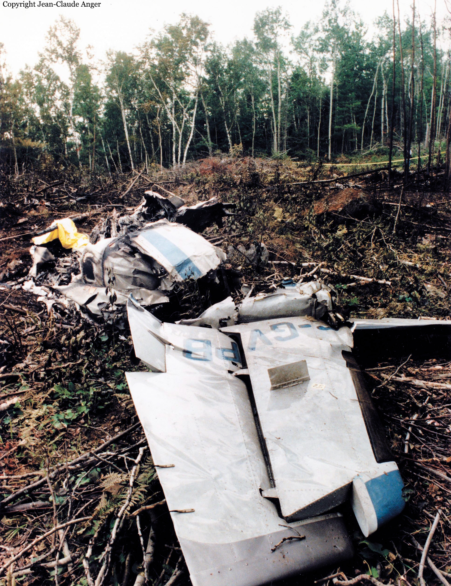
The flight was a private pleasure/travel flight for the purpose of transporting the pilot, his wife, and two other couples from Windsor to Killarney, Ontario, where they were to spend the weekend with friends. The flight had been planned in advance of the departure date. The pilot commenced taxiing at 1058 eastern daylight saving time (EDT), and was issued an instrument flight rules (IFR) clearance to Killarney via the routing "Windsor, radar vectors Sarnia, direct Wiarton, direct Killarney, to maintain 3,000" feet asl. The pilot took off at 1105. After take-off, the flight proceeded in a routine manner in accordance with the IFR clearance and was issued a final cruise altitude of 9,000 feet asl. The pilot reported level at 9,000 feet asl at 1125. At 1137, while the flight was 65 to 70 nm southwest of Wiarton, Ontario, the pilot was issued and acknowledged a clearance to fly direct to Killarney. At 1151, he requested and was issued a clearance to climb to 12,000 feet asl to get above a cloud layer, and reported level at 12,000 feet asl at 1155. The flight passed 20 nm to the west of Wiarton at 1203. At 1206, the pilot was given the Sudbury altimeter setting of 29.913 and was cleared to maintain 4,000 feet asl at his convenience. He acknowledged the clearance and commenced descent from 12,000 feet asl, 62 nm south of Killarney. Shortly after issuing the descent clearance, the air traffic services (ATS) controller advised the pilot that the IFR flight plan could be cancelled with the controller on his frequency while still airborne or with the Sault Ste. Marie flight service station (FSS) on the ground by a toll free telephone number. The ATS controller asked the flight crew of another aircraft on the same frequency to listen for an IFR cancellation from C-GSEV and to relay the cancellation to the controller. At 1221, the pilot of C-GSEV advised the ATS controller that he would be descending to 2,000 feet asl. The controller advised the pilot that the flight was in uncontrolled airspace and descent would be at the pilot's discretion. The pilot acknowledged the message, and this was the last direct controller/pilot communication (DCPC) between ATS and the aircraft. The last recorded radar position of the aircraft was at 1223:43, when it slowed to 180 knots ground speed and was descending out of 3,000 feet asl, 3 1/2 to 4 nm south of the Killarney airport. At about 1224, the flight crew from another aircraft on the frequency advised the ATS controller that C-GSEV had cancelled the IFR flight plan. There was no further communication with the flight after the pilot cancelled the IFR flight plan. The aircraft was reported missing to officials of the pilot's company the following morning by friends and family of the passengers. Search and rescue authorities were notified at approximately 0930, and the wreckage was located by search and rescue late that afternoon. The aircraft struck the rock face of a mountain at 1,321 feet asl in near level flight, on a northeast heading. The top of the mountain was 1,408 feet asl. The six occupants were fatally injured, and the aircraft was destroyed on impact. The accident occurred at about 1230 EDT during the hours of daylight, at latitude 46°02'N and longitude 081°26'W.
Crew:
Emidio Simone, pilot.
Passengers:
Laila Simone,
William and Lynne Bolton,
David and Pauline Moore.
Probable cause:
The pilot was operating the aircraft in instrument meteorological conditions and uncontrolled airspace while below a safe terrain clearance altitude, and the aircraft struck a mountain.
Final Report:

Crash of a Cessna 421C Golden Eagle III in Charlevoix: 6 killed

Date & Time: Aug 3, 1994 at 1950 LT
Registration:
C-GVPB
Flight Phase:
Survivors:
No
Schedule:
Charlevoix - Trois-Rivières
MSN:
421C-0484
YOM:
1973
Country:
Crew on board:
1
Crew fatalities:
Pax on board:
5
Pax fatalities:
Other fatalities:
Total fatalities:
6
Captain / Total flying hours:
5261
Captain / Total hours on type:
1215.00
Aircraft flight hours:
3190
Circumstances:
Around 1950 eastern daylight saving time (EDT), the Cessna 421C aircraft, registration C-GVPB, operated by les Ailes de Charlevoix inc., took off on a visual flight rules (VFR) charter flight from Charlevoix Airport, Quebec, to Trois-Rivières, Quebec, with one pilot and five passengers on board. Shortly after take-off, witnesses saw greyish smoke emanating from the left engine. The aircraft entered a steep left turn followed by a descent. It then continued in the new direction. Shortly after, the aircraft yawed and entered an uncontrolled roll, nosed down, and crashed. The aircraft caught fire on impact. All six occupants were fatally injured during the impact. The aircraft was destroyed.
Probable cause:
It is probable that a loss of oil pressure in the left engine caused a loss of power just after take-off. The pilot was unable to maintain the minimum control speed (VMC) of the aircraft.
Final Report:

Crash of a Douglas C-47A-5-DK in Fort Simpson

Date & Time: Jun 26, 1994 at 1404 LT
Operator:
Registration:
C-FROD
Flight Type:
Survivors:
Yes
Schedule:
Big Trout Lake – Fort Simpson
MSN:
12307
YOM:
1942
Flight number:
BFL526
Country:
Crew on board:
2
Crew fatalities:
Pax on board:
0
Pax fatalities:
Other fatalities:
Total fatalities:
0
Captain / Total flying hours:
14000
Captain / Total hours on type:
9000.00
Copilot / Total flying hours:
1300
Copilot / Total hours on type:
850
Aircraft flight hours:
18456
Circumstances:
Buffalo Air Flight 526, a Douglas DC-3C freighter based in Yellowknife, was hauling jet fuel to Trout Lake from Fort Simpson, Northwest Territories, in support of forest fire suppression operations. Before the departure from Yellowknife to Trout Lake, the flight crew checked the en route weather and filed a company flight itinerary. Dispatch issued the flight crew an aircraft-fuel-load receipt which indicated that the aircraft had been fuelled the night before with a total fuel quantity of about 436 imperial gallons (imp. gal.): full main tanks (336 imp. gal.), and 50 gallons in each auxiliary tank (100 imp. gal.). The first officer confirmed this quantity with a fuel dip-stick borrowed from the refueller. At 07:40 mountain daylight saving time, the flight crew departed Yellowknife in accordance with visual flight rules (VFR). On board the aircraft were 17 full 45-imperial-gallon drums of Turbo-B jet fuel. At 09:25 the aircraft landed at Trout Lake, and the 17 drums of jet fuel were off-loaded; the aircraft then departed for Fort Simpson at 0945. The 82-nautical-mile (nm) flight to Fort Simpson was flown at an altitude of about 2,500 feet above sea level (asl); the flight crew reported encountering light headwinds. At 10:20 the aircraft landed at Fort Simpson. Once again 17 drums of jet fuel were loaded on board, then the aircraft departed at 10:49. The captain climbed the aircraft to an altitude of 3,500 feet asl. After he levelled off the aircraft, the captain adjusted the engines to 575 brake horsepower (bhp) settings. At 11:20, the aircraft landed at Trout Lake and the drums were off-loaded, and at 11:35 the aircraft was once again airborne on the second round-trip shuttle flight. Thirty-five minutes later the aircraft landed at Fort Simpson. While the cargo was being loaded on the aircraft, the flight crew discussed their different calculations regarding the aircraft's fuel quantity. The first officer indicated that the aircraft required fuel. The captain calculated that the aircraft had sufficient fuel remaining. The captain decided that they would refuel at Fort Simpson on the next shuttle flight; nonetheless, since the flight crew considered the cockpit fuel gauges unreliable, the captain requested that the first officer confirm the fuel quantity using a dip-stick. At 12:28, the aircraft departed Fort Simpson and climbed to 5,000 feet asl. About eight minutes later, the flight crew noticed that the fuel pressure was fluctuating, indicating that the auxiliary tanks were empty. The captain repositioned the fuel tank selectors to their respective main tanks and enquired about the dip-stick measurements. The first officer responded that he had not checked the fuel quantity because the fuel dip-stick was missing. The crew discussed the fuel quantity remaining and the captain calculated that the aircraft had approximately 45 minutes of fuel remaining. Following the 13:00 touchdown at Trout Lake, the cargo was unloaded and 31 empty fuel drums were loaded on board the aircraft for Fort Simpson. At 13:25 the aircraft departed Trout Lake. The first officer was the pilot flying (PF) the aircraft, and was in the right seat. The captain performed the duties of the pilot not flying (PNF). Twenty miles southwest of Fort Simpson, the PNF reported their position to Fort Simpson Flight Service Station (FSS). He also requested that the aircraft refueller be advised that they would require fuel on arrival. The flight crew then completed the descent checks and, at 10 miles southwest of the airport, the PNF updated FSS of their position and received the airport advisory. Approximately six miles from the airport, at an altitude of about 400 to 500 feet above ground level (agl), the PF advised the PNF that the left engine was losing fuel pressure. Shortly thereafter, the left engine lost power. Immediately, the PNF switched the left fuel boost pump to the ON position, and the left fuel selector from LEFT MAIN to LEFT AUXILIARY tank position. The engine resumed power momentarily, but lost power again. The PNF then switched the left fuel selector to the RIGHT AUXILIARY tank position and the engine regained power; however, it promptly lost power again. Realizing that the fuel had been depleted in three of the four tanks, the captain took control of the aircraft and headed straight for runway 31. As the captain called for the engine failure check for the left engine, the first officer advised the captain that the right engine was losing power. With a loss of power in both engines, and without sufficient altitude to glide to the airport, the first officer called the Fort Simpson FSS to advise that the flight crew would attempt a landing on the road (Mackenzie Highway) north of the Liard River. However, the approach to the road was unsuccessful and the aircraft crash-landed into a treed area. At about 14:03, several witnesses at the Liard River ferry crossing observed the aircraft flying low in a northwesterly direction. The aircraft was estimated to be at about 40 feet agl when it crossed overhead the ferry terminal and was descending. The witnesses reported that they heard the sound of the engines cutting in and out before the aircraft passed overhead their vantage points. They also reported seeing the landing gear being extended. The aircraft then disappeared from view behind the trees. Immediately thereafter, the aircraft struck trees near the road, and crashed about 1/2 nm short of runway 31. The aircraft had been flown for approximately 4 hours and 37 minutes since its last refuelling.
Probable cause:
The flight was commenced with a fuel quantity below the minimum requirements, resulting in loss of engine power because of fuel exhaustion. Contributing to the occurrence was the lack of flight crew coordination.
Final Report:

Crash of a De Havilland DHC-2 Beaver near Hunter Point: 2 killed

Date & Time: Jun 23, 1994 at 1100 LT
Type of aircraft:
Operator:
Registration:
C-FDTI
Flight Phase:
Survivors:
No
Schedule:
Hunter Point – Sandspit
MSN:
37
YOM:
1949
Country:
Crew on board:
1
Crew fatalities:
Pax on board:
1
Pax fatalities:
Other fatalities:
Total fatalities:
2
Captain / Total flying hours:
2586
Captain / Total hours on type:
1268.00
Aircraft flight hours:
11615
Circumstances:
The amphibious DHC-2 Beaver was being operated from the Harbour Air base at Sandspit, British Columbia, located on the Queen Charlotte Islands. On the first flight on the day of the accident, the aircraft carried baggage from the Sandspit Airport to a floating fishing resort at anchor in Givenchy Bay. This bay is located in the Kano Inlet on the west coast of the Queen Charlotte Islands, 28 nautical miles (nm) west of Sandspit. On board the aircraft with the pilot was a passenger who would remain with the flight for the return trip to Sandspit. The aircraft departed Sandspit under visual flight rules (VFR) at 1015 Pacific daylight time (PDT) and landed at the fishing resort at 1039. The pilot had taken the most direct route to the destination through a low pass and over Yakoun Lake. He advised the company dispatch on the company radio frequency that the weather was quite poor along that route and that he planned to take the Skidegate Channel for the return trip. On arrival at the Givenchy resort, the aircraft was loaded with the fish to be transported to Sandspit; it then departed Givenchy at 1051. When the aircraft did not arrive at Sandspit, a search was organized. The wreckage was located at 1245 at Hunter Point, about 7 nm from Givenchy, at latitude 53°15'N, longitude 132°42'W. The accident had occurred during the hours of daylight at approximately 1100. The aircraft was destroyed and the pilot and passenger were fatally injured upon impact.
Probable cause:
The aircraft likely stalled at an altitude insufficient to permit recovery. The reason why the aircraft may have stalled could not be determined.
Final Report:

Crash of a Cessna 441 Conquest in Fort Frances

Date & Time: Jun 18, 1994 at 0425 LT
Type of aircraft:
Operator:
Registration:
N441CA
Flight Phase:
Survivors:
Yes
Schedule:
Milwaukee – Fort Frances – God’s Lake Narrows
MSN:
441-0046
YOM:
1978
Country:
Crew on board:
1
Crew fatalities:
Pax on board:
5
Pax fatalities:
Other fatalities:
Total fatalities:
0
Captain / Total flying hours:
4800
Captain / Total hours on type:
40.00
Aircraft flight hours:
2447
Circumstances:
The pilot of the Cessna 441 Conquest was conducting an international charter flight from General Mitchell International Airport in Milwaukee, Wisconsin, to Gods Lake Narrows, Manitoba. The pilot landed the aircraft at Fort Frances, Ontario, to clear customs and refuel, and then continued his visual flight rules (VFR) flight to Gods Lake Narrows. During the take-off at Fort Frances, the aircraft experienced a power loss in the left engine. The pilot elected to continue the take-off but was unable to control the aircraft after it became airborne. The aircraft veered to the left and crashed on the airfield. The accident occurred at 0425 central daylight time (CDT), at night, on the Fort Frances Municipal Airport. All seven occupants sustained minor injuries and the aircraft was damaged beyond repair.
Probable cause:
The pilot lost control of the aircraft during take-off when the left engine lost power as a result of bird ingestion. Contributing to the loss of aircraft control were a take-off weight in excess of the maximum allowable, and a centre of gravity aft of the centre of gravity limit.
Final Report:

Crash of a Swearingen SA26T Merlin IIA in Thompson: 2 killed

Date & Time: Jun 1, 1994 at 0001 LT
Type of aircraft:
Operator:
Registration:
C-FFYC
Flight Type:
Survivors:
Yes
Schedule:
Coral Harbour – Churchill – Thompson
MSN:
T26-36
YOM:
1969
Country:
Crew on board:
2
Crew fatalities:
Pax on board:
1
Pax fatalities:
Other fatalities:
Total fatalities:
2
Captain / Total flying hours:
20000
Captain / Total hours on type:
3160.00
Copilot / Total flying hours:
3700
Copilot / Total hours on type:
375
Aircraft flight hours:
12633
Circumstances:
The twin-engine turboprop aircraft had just completed a medical evacuation (MEDEVAC) flight from Coral Harbour, Northwest Territories (NWT), to Churchill, Manitoba. At 2257 central daylight saving time (CDT), the aircraft departed Churchill for a night, instrument flight rules (IFR) flight to return to the aircraft's base of operations at Thompson, Manitoba. The en route portion of the return leg was conducted at an altitude of 18,000 feet above sea level (asl). Approximately one hour after take-off, the aircraft commenced an approach to the Thompson Airport. The crew remained in radio contact with air traffic control (ATC) personnel until approximately 2359 CDT. Just after midnight (0001 CDT), the Hotel non-directional beacon (NDB), which is located 3.4 miles northeast of the Thompson Airport, stopped transmitting. Ninety minutes later, the search and rescue satellite system (SARSAT) picked up an emergency locator transmitter (ELT) signal to the northeast of the airport. Thompson Airport staff, who had been dispatched to the site of the failed navigation beacon, found the wreckage of the aircraft in and around the NDB transmitter compound. Emergency responses were initiated by various airport and local authorities.
Probable cause:
The flight crew lost altitude awareness during the localizer back course approach and allowed the aircraft to descend below a mandatory level-off altitude. Contributing factors to this occurrence were the crew's deviation from a published approach procedure, ineffective in-flight monitoring of the approach, rapidly developing localized fog conditions, and, probably, pilot fatigue.
Final Report:

Crash of an IAI-1124A Westwind in Meadow Lake: 2 killed

Date & Time: Jan 27, 1994 at 0855 LT
Type of aircraft:
Operator:
Registration:
C-FMWW
Flight Type:
Survivors:
No
Schedule:
Edmonton - Meadow Lake
MSN:
380
YOM:
1982
Country:
Crew on board:
2
Crew fatalities:
Pax on board:
0
Pax fatalities:
Other fatalities:
Total fatalities:
2
Captain / Total flying hours:
15600
Captain / Total hours on type:
1000.00
Copilot / Total flying hours:
3200
Copilot / Total hours on type:
1500
Aircraft flight hours:
4810
Circumstances:
The privately owned Israel Aircraft Industries (IAI) Westwind II aircraft was en route from the Edmonton Municipal Airport, Alberta, to the Meadow Lake aerodrome, Saskatchewan. Low ceilings and reduced visibility were reported in the vicinity of the destination aerodrome. The crew completed a straight-in instrument approach to runway 08 at Meadow Lake, and began a circling procedure to the south of the aerodrome in order to set up to land on runway 26. The aircraft passed overhead the aerodrome at an altitude of approximately 400 feet above ground level (agl). It then turned and proceeded in level flight towards the southeast. Approximately two and one-half miles from the aerodrome, the aircraft entered a number of steep-banked rolling manoeuvres. Immediately following these manoeuvres, the aircraft descended and struck the ground in a nose-high, slightly right-wing-low attitude. The ground-strike produced very high deceleration forces. The aircraft broke into several sections, internal fuel tanks ruptured, and fuel was sprayed forward and outward from the initial impact point. A severe post-crash fire erupted and engulfed the entire wreckage trail. Emergency medical service and firefighting crews responded from the town of Meadow Lake and were on the scene within minutes of the accident. Both pilots died in the crash.
Probable cause:
While circling to land on runway 26, the aircraft performed a non-typical circling procedure at a lower than published circling altitude, leading to loss of control consistent with an accelerated stall, and descended into terrain before recovery could be completed. Whiteout conditions may have contributed to this occurrence.
Final Report:

Crash of a Piper PA-31-310 Navajo C in Lourdes-de-Blanc-Sablon: 2 killed

Date & Time: Jan 11, 1994 at 1854 LT
Type of aircraft:
Operator:
Registration:
C-GDOU
Flight Type:
Survivors:
No
Schedule:
Saint Anthony - Lourdes-de-Blanc-Sablon
MSN:
31-7612033
YOM:
1976
Country:
Crew on board:
2
Crew fatalities:
Pax on board:
0
Pax fatalities:
Other fatalities:
Total fatalities:
2
Captain / Total flying hours:
8000
Captain / Total hours on type:
1550.00
Copilot / Total flying hours:
1079
Copilot / Total hours on type:
650
Aircraft flight hours:
11050
Circumstances:
On 11 January 1994, the crew were on a chartered round-robin flight on a PA-31 Navajo, between Lourdes-de-Blanc-Sablon airport, Quebec, and St. Anthony, Newfoundland, in accordance with visual flight rules (VFR) . During the return flight, at night, the crew advised the St. Anthony flight service station (FSS) that they departed at 1813 Newfoundland standard time (NST). At 1846 NST, the crew transmitted that they were flying at 2,500 feet and that they were 32 nautical miles (nm) and 13 minutes southeast of Blanc-Sablon. Seven minutes later, the crew called the Sept-Iles FSS through the Blanc-Sablon repeater. They requested airport information and reported being 16 nm and six minutes from the airport. After receiving information on the winds and the altimeter setting, the crew reported that they would use runway 05 and would call back on final. No further transmissions were received from the crew. Fishermen found the wreckage seven months later.
Probable cause:
The cause of the occurrence could not be determined; however, it is probable that the pilots did not monitor the altimeter properly and allowed the aircraft to descend until it struck the surface of the ice.
Final Report: