Crash of a Piper PA-31-350 Navajo Chieftain in Sioux Lookout: 5 killed

Date & Time: May 1, 1995 at 1330 LT
Operator:
Registration:
C-GYPZ
Flight Phase:
Survivors:
No
Schedule:
Sioux Lookout - Red Lake
MSN:
31-7652168
YOM:
1976
Flight number:
SNY3101
Country:
Crew on board:
1
Crew fatalities:
Pax on board:
4
Pax fatalities:
Other fatalities:
Total fatalities:
5
Captain / Total flying hours:
1250
Captain / Total hours on type:
1000.00
Aircraft flight hours:
6784
Circumstances:
Bearskin flight 362, a Fairchild Swearingen Metro 23, departed Red Lake, Ontario, at 1300 central daylight saving time (CDT), with two pilots and one passenger on board, en route to Sioux Lookout on an instrument flight rules (IFR) flight plan. At approximately 30 nautical miles (nm) north of Sioux Lookout, the flight was cleared by the Winnipeg area control centre (ACC) for an approach to the Sioux Lookout airport. Air Sandy flight 3101, a Piper Navajo PA-31, departed Sioux Lookout at 1323 with one pilot and four passengers on board en route to Red Lake on a visual flight rules (VFR) flight. The pilot of Air Sandy 3101 reported clear of the Sioux Lookout control zone at 1326. No other communication was heard from the Air Sandy flight. At 1315 the Winnipeg ACC controller advised the Sioux Lookout Flight Service specialist that Bearskin 362 was inbound from Red Lake, estimating Sioux Lookout at 1332. At 1327, Bearskin 362 called Sioux Lookout Flight Service Station (FSS) and advised them they had been cleared for an approach and that they were cancelling IFR at 14 nm from the airport. At 1328, as Sioux Lookout FSS was giving an airport advisory to Bearskin 362, the specialist heard an emergency locator transmitter (ELT) emit a signal on the emergency frequencies. Moments later, the pilot of Bearskin 305, a Beechcraft B-99 in the vicinity of Sioux Lookout, advised the specialist that he had just seen a bright flare in the sky and that he was going to investigate. The pilot of Bearskin 305 stated that the flare had fallen to the ground and a fire was burning in a wooded area. A communications search was initiated to locate Bearskin 362, but the aircraft did not respond. A Search and Rescue aircraft from Trenton, Ontario, and an Ontario Ministry of Natural Resources (MNR) helicopter were dispatched to the site. The source of the fire was confirmed to be the Air Sandy aircraft. The MNR helicopter noticed debris and a fuel slick on a nearby lake, Lac Seul. It was later confirmed that Bearskin 362 had crashed into the lake. (See Appendix A.) The two aircraft collided in mid-air at 1328 during the hours of daylight at latitude 50º14'N and longitude 92º07'W, in visual meteorological conditions (VMC). All three persons on board the Bearskin aircraft and all five persons on board the Air Sandy aircraft were fatally injured.
Probable cause:
Neither flight crew saw the other aircraft in time to avoid the collision. Contributing to the occurrence were the inherent limitations of the see-and-avoid concept which preclude the effective separation of aircraft with high closure rates, the fact that neither crew was directly alerted to the presence of the other aircraft by the Flight Service specialist or by onboard electronic equipment, and an apparent lack of pilot understanding of how to optimize avoidance manoeuvring.
Final Report:

Crash of a Swearingen SA227CC Metro 23 in Sioux Lookout: 3 killed

Date & Time: May 1, 1995 at 1330 LT
Type of aircraft:
Operator:
Registration:
C-GYYB
Survivors:
No
Schedule:
Red Lake - Sioux Lookout
MSN:
CC-827B
YOM:
1993
Flight number:
BLS362
Country:
Crew on board:
2
Crew fatalities:
Pax on board:
1
Pax fatalities:
Other fatalities:
Total fatalities:
3
Captain / Total flying hours:
7330
Captain / Total hours on type:
580.00
Copilot / Total flying hours:
2810
Copilot / Total hours on type:
355
Aircraft flight hours:
3200
Circumstances:
Bearskin flight 362, a Fairchild Swearingen Metro 23, departed Red Lake, Ontario, at 1300 central daylight saving time (CDT), with two pilots and one passenger on board, en route to Sioux Lookout on an instrument flight rules (IFR) flight plan. At approximately 30 nautical miles (nm) north of Sioux Lookout, the flight was cleared by the Winnipeg area control centre (ACC) for an approach to the Sioux Lookout airport. Air Sandy flight 3101, a Piper Navajo PA-31, departed Sioux Lookout at 1323 with one pilot and four passengers on board en route to Red Lake on a visual flight rules (VFR) flight. The pilot of Air Sandy 3101 reported clear of the Sioux Lookout control zone at 1326. No other communication was heard from the Air Sandy flight. At 1315 the Winnipeg ACC controller advised the Sioux Lookout Flight Service specialist that Bearskin 362 was inbound from Red Lake, estimating Sioux Lookout at 1332. At 1327, Bearskin 362 called Sioux Lookout Flight Service Station (FSS) and advised them they had been cleared for an approach and that they were cancelling IFR at 14 nm from the airport. At 1328, as Sioux Lookout FSS was giving an airport advisory to Bearskin 362, the specialist heard an emergency locator transmitter (ELT) emit a signal on the emergency frequencies. Moments later, the pilot of Bearskin 305, a Beechcraft B-99 in the vicinity of Sioux Lookout, advised the specialist that he had just seen a bright flare in the sky and that he was going to investigate. The pilot of Bearskin 305 stated that the flare had fallen to the ground and a fire was burning in a wooded area. A communications search was initiated to locate Bearskin 362, but the aircraft did not respond. A Search and Rescue aircraft from Trenton, Ontario, and an Ontario Ministry of Natural Resources (MNR) helicopter were dispatched to the site. The source of the fire was confirmed to be the Air Sandy aircraft. The MNR helicopter noticed debris and a fuel slick on a nearby lake, Lac Seul. It was later confirmed that Bearskin 362 had crashed into the lake. (See Appendix A.) The two aircraft collided in mid-air at 1328 during the hours of daylight at latitude 50º14'N and longitude 92º07'W, in visual meteorological conditions (VMC). All three persons on board the Bearskin aircraft and all five persons on board the Air Sandy aircraft were fatally injured.
Probable cause:
Neither flight crew saw the other aircraft in time to avoid the collision. Contributing to the occurrence were the inherent limitations of the see-and-avoid concept which preclude the effective separation of aircraft with high closure rates, the fact that neither crew was directly alerted to the presence of the other aircraft by the Flight Service specialist or by onboard electronic equipment, and an apparent lack of pilot understanding of how to optimize avoidance manoeuvring.
Final Report:

Crash of a Canadair CC-144A Challenger 601 in Shearwater

Date & Time: Apr 24, 1995
Type of aircraft:
Operator:
Registration:
144613
Flight Type:
Survivors:
Yes
Schedule:
Shearwater - Shearwater
MSN:
3035
YOM:
1984
Country:
Crew on board:
4
Crew fatalities:
Pax on board:
0
Pax fatalities:
Other fatalities:
Total fatalities:
0
Circumstances:
The crew (one instructor and three pilots under training) departed Shearwater Airport on a local training mission. The crew decided to perform a flapless landing but the aircraft arrived too high and to correct the situation, the pilot-in-command nosed down when the aircraft landed very hard and bounced. The crew initiated a go-around procedure and decided to follow a holding pattern after being informed by ATC based in the tower that the right main gear seems to be damaged. About 40 minutes later, the right main gear fell away. The right engine then lost power and a fire erupted in the right wheel well. The crew declared an emergency and was cleared to return to Shearwater Airport. Upon landing, the aircraft sank on its right side then rolled for few dozen metres before coming to rest, bursting into flames. All four occupants escaped uninjured before an explosion occurred in the central fuel tank.
Probable cause:
It was determined that during the first hard landing, the right main gear was seriously damaged upon impact as well as hydraulic and fuel line.

Crash of a Douglas DC-3C in Lake Bondesir

Date & Time: Mar 23, 1995
Type of aircraft:
Operator:
Registration:
C-GCXD
Flight Phase:
Flight Type:
Survivors:
Yes
MSN:
14167/25612
YOM:
1944
Country:
Crew on board:
2
Crew fatalities:
Pax on board:
0
Pax fatalities:
Other fatalities:
Total fatalities:
0
Circumstances:
While taking off from the icy Lake Bondésir, the left ski struck an ice ridge on the ground. The main gear/ski collapsed and the aircraft came to rest. Both pilots escaped uninjured while the aircraft was damaged beyond repair.

Crash of a Douglas C-47B-DL in Lake Manitou

Date & Time: Mar 12, 1995
Operator:
Registration:
C-FDTT
Flight Type:
Survivors:
Yes
Schedule:
Mingan - Lake Manitou
MSN:
14170/25615
YOM:
1944
Country:
Crew on board:
3
Crew fatalities:
Pax on board:
0
Pax fatalities:
Other fatalities:
Total fatalities:
0
Circumstances:
Upon landing, one of the ski struck an ice ridge on the ground and cartwheeled. All three crew members escaped uninjured and the aircraft was damaged beyond repair.

Crash of a Mitsubishi MU-300 Diamond IA in Jasper

Date & Time: Mar 1, 1995 at 0920 LT
Type of aircraft:
Operator:
Registration:
C-GLIG
Survivors:
Yes
Schedule:
Williams Lake - Jasper
MSN:
76
YOM:
1984
Country:
Crew on board:
2
Crew fatalities:
Pax on board:
2
Pax fatalities:
Other fatalities:
Total fatalities:
0
Captain / Total flying hours:
3500
Captain / Total hours on type:
360.00
Copilot / Total flying hours:
13500
Copilot / Total hours on type:
350
Aircraft flight hours:
3290
Circumstances:
The Mitsubishi MU-300 Diamond business jet was on an instrument flight rules (IFR) flight from Williams Lake, British Columbia, to Hinton, Alberta. There were two pilots and two passengers on board. Prior to issuing the descent clearance from flight level 270 (FL270), the Edmonton Area Control Centre (ACC) advised the crew of the Jasper townsite, Alberta, weather. The winds were reported as calm. The crew cancelled the IFR during the descent and continued for a visual approach and landing to runway 02 at the Jasper-Hinton Airport. During the approach, the crew encountered moderate turbulence on short final. The captain increased the reference airspeed (Vref) from 105 to 115 knots to allow for subsiding air and airspeed fluctuations. The crew noted that the wind sock for runway 02 was fully extended and was varying in direction frequently. They elected to continue the approach and landing on runway 02. Power was reduced to idle at 50 feet. The aircraft touched down at about 1,000 feet down the runway. During the landing roll, the captain first applied maximum braking and then, when he determined that the aircraft would not come to a stop in the remaining runway distance available, he initiated commanded swerving to assist in stopping the aircraft; the aircraft skidded to a position 255 feet off the end of the runway. The aircraft sustained substantial damage; however, the occupants were uninjured. The accident occurred at latitude 53°19'N, longitude 117°45'W, at an elevation of 4,016 feet above sea level (asl), at 0920 mountain standard time (MST), during the hours of daylight.
Probable cause:
The aircraft overran the runway because the crew landed with a 14- to 21-knot tailwind. Contributing to the occurrence were the crew's belief that the calm winds given to them by the Area Control Centre for Jasper townsite were for the Jasper-Hinton Airport, and their decision to continue with the straight-in approach procedure without overflying the airport.
Final Report:

Crash of a Beechcraft A100 King Air in Big Trout Lake

Date & Time: Feb 21, 1995 at 1248 LT
Type of aircraft:
Operator:
Registration:
C-GYQT
Survivors:
Yes
Schedule:
Sioux Lookout - Big Trout Lake
MSN:
B-189
YOM:
1974
Flight number:
BLS324
Country:
Crew on board:
2
Crew fatalities:
Pax on board:
9
Pax fatalities:
Other fatalities:
Total fatalities:
0
Captain / Total flying hours:
5000
Captain / Total hours on type:
1500.00
Copilot / Total flying hours:
2300
Copilot / Total hours on type:
800
Aircraft flight hours:
13739
Circumstances:
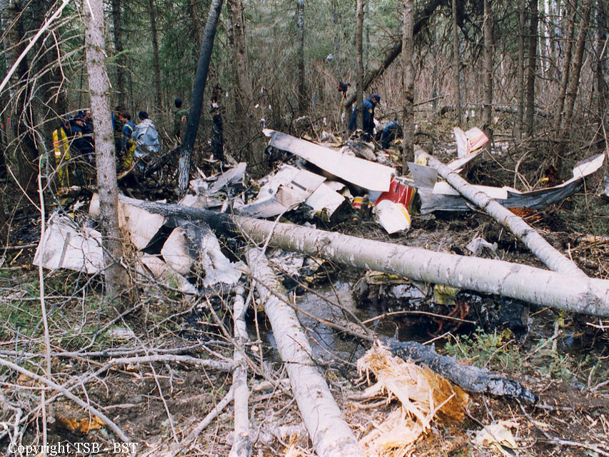
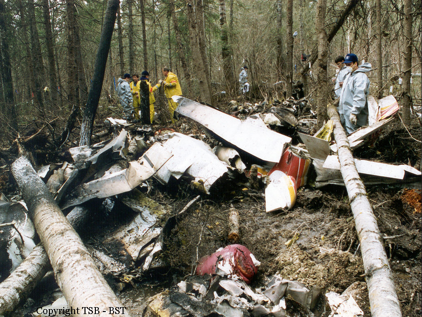
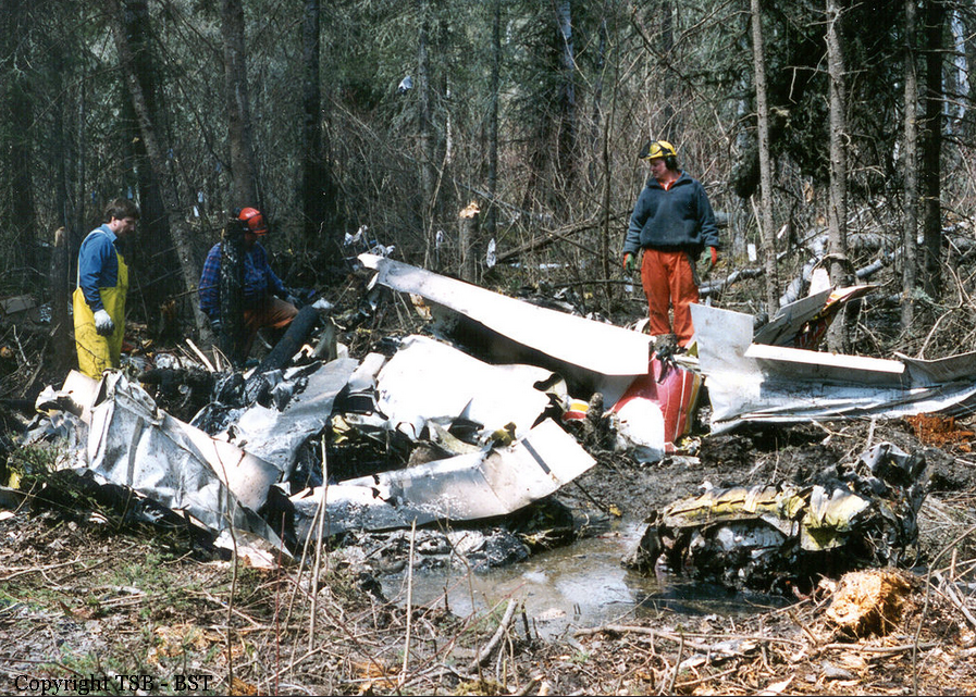
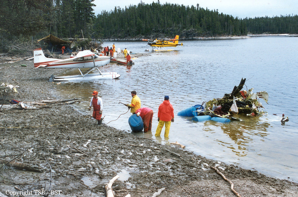
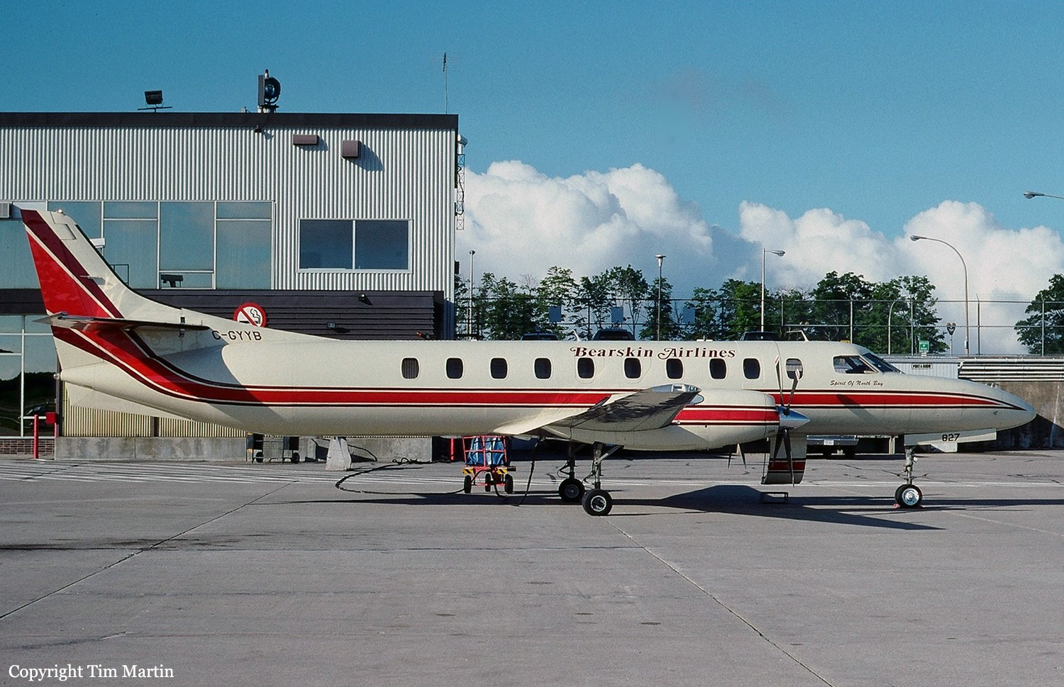
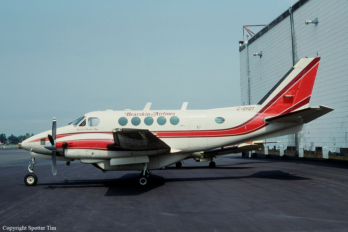
The crew of the Beechcraft A100, C-GYQT, were conducting a scheduled flight from Sioux Lookout, Ontario, to Big Trout Lake, Ontario, as Bearskin (BLS) 324. BLS324 departed Sioux Lookout with nine passengers and a crew of two at 1133 central standard time (CST) and arrived in the vicinity of Big Trout Lake at approximately 1240. The captain briefed an instrument approach with a circling procedure to runway 14. On descent to the radio beacon, the crew reportedly encountered flight visibilities of one mile and were in visual contact with the ground. When the aircraft was less than five miles from the airport, the crew heard a position report from another aircraft completing an approach to the airport. To ensure safe separation from the aircraft ahead, the captain elected to fly under visual flight rules to the southwest of the airport. Air Traffic Services radar data was obtained from the Big Trout Lake radar source. The radar data indicated that the crew descended to about 150 feet above ground level (agl) approximately 4.5 miles from the end of the landing runway and maintained 200 to 300 feet agl for some 50 seconds prior to impact. Immediately prior to impact, the radar data indicated that the aircraft was about 3 1/2 miles from the runway at about 300 feet agl and descending at more than 1,200 feet per minute. Throughout the approach, the first officer flew the aircraft visually with occasional reference to his instruments, while the captain navigated and maintained terrain clearance by visual reference to the terrain and issued instructions to the first officer. At approximately five miles from the runway, the crew turned onto the extended centre line of the runway and received a radio report from the other aircraft of local visibilities of less than 1/2 mile. The aircraft flew inbound over a wide expanse of lake, and the captain lowered the flaps in preparation for landing. Shortly thereafter, the captain became concerned with the reducing visibility and looked in the Company Approach Procedures binder that he held on his lap. The captain was aware of the danger of whiteout and intended to revert to instrument flight if whiteout were encountered. He had not previously removed the approach chart for Big Trout Lake and clipped it in the approach chart holder because he had discovered that the binder rings were broken and taped shut when he had performed his initial approach briefing. He intended to provide new approach information to the first officer so that a full instrument approach could be initiated from their current position. When the captain looked up from the binder, he observed the altimeter indicating a descent through 1,000 feet above sea level (asl) and called to the first officer, "Watch your altitude." Before a recovery could be initiated, the aircraft struck the frozen surface of the lake and bounced into the air. The captain initiated a recovery and then, concerned with the airworthiness of the aircraft, reduced power and attempted to land straight ahead. The aircraft crashed onto the frozen surface of the lake about 3/4 mile beyond the initial impact location. All passengers and crew survived the accident. However, the crew and several passengers sustained serious injuries. Rescuers from the local community reached the aircraft about two hours after the crash and all survivors were rescued within four hours. The more seriously injured were experiencing the effects of hypothermia when rescued. The accident occurred at 1248 CST, approximately three miles northwest of Big Trout Lake Airport, at latitude 53°49'N, longitude 089°53'W, at an elevation of 690 feet asl.
Probable cause:
While the crew were manoeuvring the aircraft to land and attempting to maintain visual flying conditions in reduced visibility, their workload was such that they missed, or unknowingly discounted, critical information provided by the altimeters and vertical speed indicators. Contributing factors were the whiteout conditions and the crew's decision to fly a visual approach at low altitude over an area where visual cues were minimal and visibility was reduced.
Final Report:

Crash of a Britten-Norman BN-2A-27 Islander in Pauingassi

Date & Time: Jan 25, 1995 at 1430 LT
Type of aircraft:
Operator:
Registration:
C-GSGK
Survivors:
Yes
MSN:
383
YOM:
1974
Country:
Crew on board:
1
Crew fatalities:
Pax on board:
1
Pax fatalities:
Other fatalities:
Total fatalities:
0
Circumstances:
On final approach to Pauingassi, the twin engine aircraft was too low and struck the ground short of the airstrip. It came to rest in snow and was damaged beyond repair. Both occupants escaped uninjured.
Probable cause:
It is believed that the pilot misjudged the distance with the landing area and may have suffered a optical illusion caused by the reflection of the sun on the snow.

Crash of a Learjet 35 off Masset: 5 killed

Date & Time: Jan 11, 1995 at 0149 LT
Type of aircraft:
Operator:
Registration:
C-GPUN
Flight Type:
Survivors:
No
Schedule:
Vancouver - Masset
MSN:
35-058
YOM:
1976
Country:
Crew on board:
2
Crew fatalities:
Pax on board:
3
Pax fatalities:
Other fatalities:
Total fatalities:
5
Captain / Total flying hours:
4550
Captain / Total hours on type:
2550.00
Copilot / Total flying hours:
2880
Copilot / Total hours on type:
61
Aircraft flight hours:
11676
Circumstances:
On 11 January 1995, at 0035 Pacific standard time (PST), the twin-engine Learjet 35 departed Vancouver International Airport, British Columbia, on a night, instrument flight rules (IFR), medical evacuation (MEDEVAC) flight to the Masset aerodrome, on the northern end of the Queen Charlotte Islands. On board the Learjet were a flight crew of two pilots, and a medical team consisting of two attendants and a doctor. Their mission was to evacuate a patient from Masset and deliver her to Prince Rupert for treatment; the aircraft was then to return to Vancouver. The flight-planned route was at flight level (FL) 390, direct to Sandspit then direct to Masset. Following routine communications with Air Traffic Services (ATS), at about 0144, the aircraft reported "outbound" from the Masset non-directional beacon (NDB) on the published NDB "A" instrument approach procedure to runway 12. Air Traffic Control (ATC) radar, situated near Sandspit, tracked the aircraft as it flew the approach. Radar data shows that the aircraft began a descent about 10 seconds after it had completed the procedure turn and was established on the final inbound approach track. Forty-three seconds later, at a point 8.8 nautical miles (nm) from the threshold of runway 12 and on the final, inbound track, the aircraft disappeared from radar. Department of National Defence (DND) Search and Rescue (SAR) aircraft began searching the area shortly after the aircraft was declared missing, and were later assisted by other private and military aircraft and vessels. On the second day of the search, flotsam from the aircraft was found in the area. Extensive underwater searching using sonar and underwater cameras found the aircraft wreckage on 31 January 1995, in 260 feet of water, near the last known position. The aircraft had been destroyed. The bodies of two occupants were found several days after the accident, but the other three occupants have not been found and are presumed to have been fatally injured. The accident occurred at latitude 54/08NN and longitude 131/58NW, at about 0149 PST, during the hours of darkness in unknown weather conditions.
Probable cause:
The crew most likely conducted the instrument approach with reference to an unintentionally mis-set altimeter of 30.17 in. Hg, and unknowingly flew the aircraft into the water. The circumstances leading to the incorrect altimeter setting could not be determined, nor was it determined why the crew did not detect the mis-set altimeter.
Final Report:

Crash of a Cessna 402B in Le Havre-Saint-Pierre

Date & Time: Nov 23, 1994 at 1714 LT
Type of aircraft:
Operator:
Registration:
C-FFAS
Flight Type:
Survivors:
Yes
Schedule:
Lourdes-de-Blanc-Sablon - Le Havre-Saint-Pierre
MSN:
402B-0820
YOM:
1975
Flight number:
ASJ638
Country:
Crew on board:
1
Crew fatalities:
Pax on board:
0
Pax fatalities:
Other fatalities:
Total fatalities:
0
Captain / Total flying hours:
689
Captain / Total hours on type:
29.00
Aircraft flight hours:
7012
Circumstances:
The Air Satellite Cessna 402B, flight 638, took off from Lourdes-de-Blanc-Sablon, Quebec, on an instrument flight rules (IFR) flight to Havre-Saint-Pierre, Quebec, with a load of mail. At 6,000 feet above sea level (asl), meteorological conditions were visual (VMC). About 35 nautical miles (nm) from Havre-Saint-Pierre, the pilot began his descent. At 25 nm from the airport and at an altitude of 5,000 feet asl, the pilot contacted the Flight Service Station (FSS) specialist at Sept-Îles, Quebec, via the remote communications outlet (RCO). He requested weather information for Havre-Saint-Pierre Airport. The specialist gave him the latest weather report available for the Havre-Saint-Pierre FSS. The report had been issued three hours previously by Environment Canada. The meteorological sequence indicated VMC. The pilot could see the town of Havre-Saint-Pierre when he commenced his back course approach for runway 27. During the descent, the aircraft flew into snow showers. The pilot contacted the company to check the weather at Havre-Saint-Pierre Airport, and he was told there was light snow. The pilot continued the approach to the MDA indicated on the Havre-Saint-Pierre approach chart, that is, 420 feet asl. There was moderate turbulence during the approach. The pilot tried to maintain control of the aircraft while operating the radio in an attempt to obtain more detailed weather information. One of the company pilots told him the snowfall was heavier. The aircraft then banked right. The pilot corrected, and, at the same time, the wheels touched the ground. The aircraft crashed and slid on its belly about 100 feet before coming to rest. The pilot sustained minor injuries; the aircraft sustained substantial damage. The accident occurred about 1.5 nm from the threshold of Havre-Saint-Pierre runway 27 on marshy ground. The pilot remained in radio contact with overflying aircraft and said he would stay on board the aircraft until rescuers arrived. Search and rescue crews walked toward the crash site, but they were unable to find the aircraft because of the rough terrain and reduced visibility. Five hours later, a Search and Rescue helicopter located the aircraft with the aid of the direction finder. The weak signal from the emergency locator transmitter (ELT) was still readable and was received. The pilot was transported to hospital for first aid treatment.The accident occurred during the hours of darkness.
Probable cause:
The pilot continued the descent below the MDA without the required visual references.
Final Report: