Crash of a Douglas C-47A-30-DK in Niigata

Date & Time: Jan 27, 1955
Operator:
Registration:
43-48091
Flight Type:
Survivors:
Yes
MSN:
13907/25352
YOM:
1944
Location:
Country:
Region:
Crew on board:
0
Crew fatalities:
Pax on board:
0
Pax fatalities:
Other fatalities:
Total fatalities:
0
Circumstances:
Crashed on landing for unknown reason. There were no casualties.

Crash of a Douglas C-47A-25-DK in Guwahati: 3 killed

Date & Time: Jan 21, 1955 at 0729 LT
Operator:
Registration:
VT-COZ
Flight Type:
Survivors:
No
Schedule:
Calcutta – Guwahati
MSN:
13569
YOM:
1944
Location:
Country:
Region:
Crew on board:
3
Crew fatalities:
Pax on board:
0
Pax fatalities:
Other fatalities:
Total fatalities:
3
Circumstances:
The aircraft took off from Calcutta-Dum Dum Airport on a scheduled freighter service flight at 0546 hours Indian Standard Time and set course for Guwahati, carrying a crew of three. At 0722 hours, the aircraft contacted Air Traffic Control, Guwahati, on radio telephony and reported flying under visual flight rules, 25 miles away from Guwahati Airport at an altitude of 6 000 feet. The Air Traffic Control Officer on duty passed the altimeter setting to the aircraft, cleared it to descend under VFR and instructed it to call when ten miles from the airport. The aircraft asked for a bearing on frequency 119.7 (Homer) at 0725 hours and a bearing of 045° class 'A' was given. This was confirmed as correct by the aircraft, which also reported being 15 miles from the airport at a height of 3 000 feet at that time. The next contact with Guwahati Tower was at 0727 hours when it reported being at a distance of 10 miles from the airport. Landing instructions were passed to the aircraft and it was asked to call again on joining circuit. There was no further communication with the aircraft. At approximately 0729 the duty officer at the tower noticed black smoke at the top of a patch of fog to the south of the airport. Repeated calls were made to the aircraft on 118.1 Mc/S and 6 440 Kc/S but no response was received. At about the same time persons in Tarapati village saw the aircraft hit some arecanut trees, crash in a field and burst into flames. The captain and the copilot died instantly and the radio officer died en route to the hospital. The aircraft was destroyed.
Probable cause:
The aircraft crashed in the course of a premature descent, during the final approach, as a result of hitting arecanut trees which were obscured from view by fog in the area. Some other points which call for observations have come out in the course of the evidence and though they do not directly pertain to the cause of this accident are well worth mentioning.
- Operational control was not exercised for this flight and the operator had not designated a representative for this purpose as required by Notice to Air- men No. 29 of 1952,
- The meteorological briefing of the pilot was not complete in as much as the terminal weather forecast for the alternate aerodrome was not obtained by him,
- The manuals used by the crew of this aircraft were not complete or up-to-date.
Final Report:

Crash of a Douglas C-47-DL in Cincinnati: 2 killed

Date & Time: Jan 12, 1955 at 0904 LT
Operator:
Registration:
N999B
Flight Phase:
Flight Type:
Survivors:
No
Schedule:
Battle Creek – Lexington – Miami
MSN:
4255
YOM:
1942
Crew on board:
2
Crew fatalities:
Pax on board:
0
Pax fatalities:
Other fatalities:
Total fatalities:
2
Circumstances:
The crew departed Battle Creek Airport at 0733LT bound for Miami with an intermediate stop at Lexington, Kentucky. While cruising at an altitude between 700 and 900 feet, the left wing of the aircraft collided with the right engine of a Trans World Airlines (TWA) Martin 202 registered N93211 that just took off from Cincinnati-Greater Cincinnati Airport. Following the collision, both aircraft went into a dive and crashed in a snow covered field and a wooded area located in the suburb of Cincinnati. Both aircraft were completely destroyed upon impact and all 15 occupants on both airplanes were killed.
Probable cause:
The probable cause of this accident was operation of the DC-3 in the control zone as unknown traffic, without clearance, very close to the base of, or in, the overcast.
Final Report:

Crash of a Douglas R4D-5 at SP-3 Polar Station

Date & Time: Dec 31, 1954
Operator:
Registration:
CCCP-N417
Flight Type:
Survivors:
Yes
MSN:
9357
YOM:
1943
Country:
Region:
Crew on board:
0
Crew fatalities:
Pax on board:
0
Pax fatalities:
Other fatalities:
Total fatalities:
0
Circumstances:
On approach to SP-3 Polar Station in foggy conditions, the airplane was too low and hit a hummocked ice ridge. On impact, the skis were sheared off and the aircraft belly landed and came to rest. There were no casualties but the aircraft was not repaired.

Crash of a Douglas C-47A-90-DL in Pittsburgh: 10 killed

Date & Time: Dec 22, 1954 at 2300 LT
Operator:
Registration:
N24320
Survivors:
Yes
Schedule:
Newark – Pittsburgh – Colorado Springs – Monterey – Seattle
MSN:
20197
YOM:
1944
Flight number:
JFS4844C
Crew on board:
5
Crew fatalities:
Pax on board:
23
Pax fatalities:
Other fatalities:
Total fatalities:
10
Captain / Total flying hours:
7600
Captain / Total hours on type:
1500.00
Copilot / Total flying hours:
2450
Copilot / Total hours on type:
800
Aircraft flight hours:
5738
Circumstances:
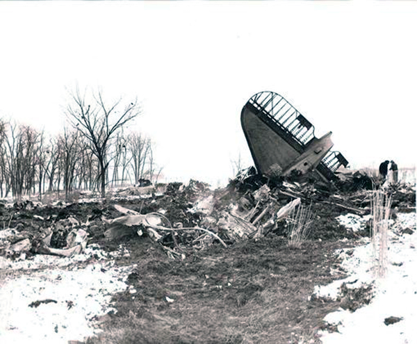
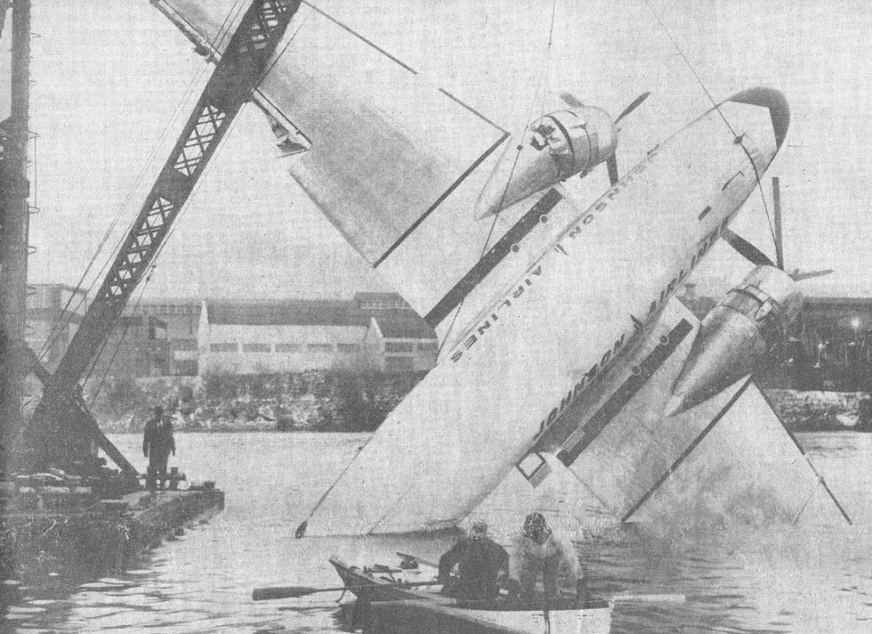
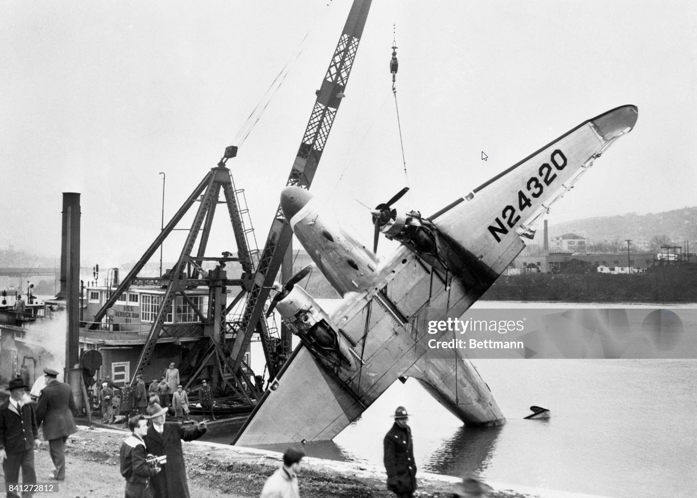
Johnson Flying Service's Plight 4844-C, December 22, 1954, was a CAM (civil air movement of military personnel) flight from Newark, New Jersey, to Tacoma, Washington, with planned intermediate stops among which were Pittsburgh, Pennsylvania; Colorado Springs, Colorado; Monterey, California; and Tacoma, Washington. The crew consisted of Captain Harold A. Poe., Captain Joseph J. Grekowicz, and Copilots Clarence E. Chapman and Charles R. Carter, Captain Robert P. Walker, the fifth crew member, was employed by the company as cabin attendant prior to the departure from Newark. The aircraft was serviced with 170 gallons of 100 octane fuel which was placed in the two main tanks in equal amounts, making a total of 225 gallons according to the weight and balance manifest. A preflight inspection of the aircraft was performed by Captain Grekowicz with no discrepancies found. According to the company's Weight and Balance Manifest the aircraft at the time of departure weighed 25,317 pounds, which was within the allowable gross weight of 25,346 pounds; the load was distributed within the prescribed limits with respect to the center of gravity of the aircraft. Prior to departing Newark, Captain Poe filled with the CAA by telephone a flight plan indicating a flight to be made in accordance with visual flight rules (VFR) to the Allegheny County Airport, Pittsburgh, Pennsylvania. The route to be followed was via Amber 7, Green 3, and Red 21 Airways. 2 The flying time to Pittsburgh was estimated to be one hour and forty minutes, at an airspeed of 155 knots 3 with two hours and forty minutes of available fuel. The flight departed Newark at 2038 with 23 passengers on board. Routine en route position reports were made and at 2206 the flight reported over Philipsburg, Pennsylvania, VFR, estimating Westover, Pennsylvania, at 2219. At approximately 2220, the Pittsburgh combined CAA station/center (INSAC and Air Route Traffic Control) heard the flight calling Altoona, Pennsylvania, radio (INSAC) on the radio frequency of 126.7 mc. As several calls to Altoona were unanswered, Pittsburgh radio attempted to contact the aircraft but was unsuccessful. Two minutes later, at 2222, Pittsburgh radio heard N 24320 calling Westover on 126.7 mc. Since Westover is a radio beacon and has no voice facilities, Pittsburgh radio again tried to contact the aircraft, but was unsuccessful. At 2225 the flight reported to Brookville, Pennsylvania, radio that it was over Westover at 2220, VFR, estimating Pittsburgh at 2252. Pittsburgh radio received a call from the flight at 2238 asking if fuel was available at "Johnson Marker." Pittsburgh interpreted this to mean Johnstown, Pennsylvania, and replied "Reference fuel at Johnstown, they do have 91/96 octane and lower and we're attempting to contact Allegheny Airlines at Johnstown now to see if they would be open at this time of night. The Air Guide doesn't list any hours that they are open. You'll have enough fuel to land at Allegheny County, original destination, won't you, over?" The pilot advised he was not sure, and then requested that the runway lights at the Johnstown Airport be turned on. Pittsburgh radio attempted to contact the Johnstown Airport by telephone and inter phone without success and advised the flight that they were unable to contact them at this time but would continue trying. At 2244, N 24320 called Pittsburgh radio and advised that it was over the Johnstown Airport. The pilot was asked to stand by and as soon as it was determined that Johnstown could not be contacted, Pittsburgh radio so advised. N 24320, at 2247, told Pittsburgh radio that it had passed Johnstown and was continuing to the Allegheny County Airport. Two minutes later Pittsburgh again asked the flight if it wished them to continue attempting to contact the Johnstown Airport. The pilot then said he would continue to Pittsburgh and asked for information on other fields where he might land. This was answered, "Douglas 4320 Pittsburgh radio. Nothing for a DC-3 Douglas 4320, it's either Greater Pittsburgh or Allegheny County, over." At 2251, Pittsburgh gave the flight the current Allegheny County weather as: Clear, temperature 20, dew-point 10, wind south-southwest 9. When asked his altitude the pilot answered 3,200 feet. He was then given the winds aloft at 3,000 feet as being 260 degrees 10 knots. A minute later the flight advised that it was 7 miles east of the Allegheny County Airport and could see it; that it was crossing the river and could see the field lights. Pittsburgh radio then called the Allegheny County tower and advised that N 24320, a DC-3, was approximately 10 miles east, low on fuel, and was landing at that airport. The tower requested that the aircraft change to tower frequency. Pittsburgh radio called the flight at 2254, and asked it to contact the tower on 121.3 mc. In reply the pilot said that he did not have 121.3 mc. but would contact the tower on 126.18 mc. He was advised that frequency was satisfactory. The flight immediately called the tower and requested landing information. It was then cleared for a straight-in approach to runway 27 and asked to report when 3 miles out. The weather was given as: Wind southwest variable south, calm to 10, altimeter 29.84. At 2256, the flight reported it was 3 miles east on final approach; it was then cleared to land. At 2257, the flight reported that it was out of gas. At this time the tower observed the aircraft to be approximately 2 miles from the airport on final approach. The tower immediately asked if the pilot believed he could make the field. The pilot replied, "I doubt it very much. We have both engines feathered, we are coming down over the red lights. I don't know if we'll make it or not. We are 2,000 feet." At 2258 the pilot advised, "We are going to set it down." The tower observed the aircraft make a left turn and head toward the south. It then disappeared from the controller's view below the hills southeast of the airport. Necessary calls pertaining to the emergency were Immediately effected. The aircraft, heading in a southerly direction, was ditched wheels up in the Monongahela River at approximately 2300. The captain, Harold A. Poe, who was flying the aircraft, and nine passengers were drowned.
Probable cause:
The Board determines that the probable cause of this accident was fuel exhaustion brought about by inadequate flight planning. Contributing factors were inadequate crew supervision and training. The following findings were reported:
- The company did not properly check the competency of the crew in accordance with their operations manual prior to flight assignment,
- The aircraft was overloaded at time of takeoff,
- The flight was improperly planned, and was not conducted in accordance with the company's operations manual,
- The captain, contrary to the company's operations manual, passed a suitable refueling facility after being advised that if the flight continued to its destination it would be necessary to use reserve fuel,
- Weather along the route was good and approximately as forecast,
- The aircraft was ditched in the Monongahela River, two miles from its destination because of fuel exhaustion.
Final Report:

Crash of a Douglas C-47A-70-DL near Ciudad Piar: 2 killed

Date & Time: Dec 18, 1954
Operator:
Registration:
YV-C-AMP
Flight Phase:
Flight Type:
Survivors:
No
Site:
Schedule:
Ciudad Bolívar – Tumeremo
MSN:
19292
YOM:
1943
Country:
Crew on board:
2
Crew fatalities:
Pax on board:
0
Pax fatalities:
Other fatalities:
Total fatalities:
2
Circumstances:
Crashed in hilly terrain located near Ciudad Piar. The wreckage was found few days later. Both pilots were killed.

Crash of a Douglas C-47A-10-DK in Pezinok: 4 killed

Date & Time: Dec 12, 1954 at 2304 LT
Operator:
Registration:
OK-WDK
Flight Type:
Survivors:
No
Schedule:
Prague – Brno – Bratislava
MSN:
12549
YOM:
1944
Country:
Region:
Crew on board:
4
Crew fatalities:
Pax on board:
0
Pax fatalities:
Other fatalities:
Total fatalities:
4
Circumstances:
The crew was performing a cargo flight from Prague to Bratislava with an intermediate stop in Brno. At 2242LT, the crew obtained the permission to descend to Bratislava via heading 225° to join the approach path for runway 23. At 2302LT, the pilot reported completing a last turn to join the glide when the airplane hit the ground about 10 km north of the airport, near Pezinok. The aircraft was destroyed by impact forces and a post crash fire and all four crew members were killed. The wreckage was found two days later only. At the time of the accident, the airplane was off course by 1,500 meters and the weather conditions were as follow: horizontal visibility 1,800 meters, broken at 80 meters and overcast at 300 meters with heavy rain falls and severe icing conditions.
Probable cause:
It is believed that the Pitot tubes heater system was OFF at the time of the accident, which cause several instruments to display wrong parameters, such the altimeters and the speed indicators. Such situation mislead the crew. This led the aircraft to descent to the insufficient height of 70 meters where the minimum safe altitude was 600 meters.

Crash of a Douglas C-47A-50-DL in Guasdualito

Date & Time: Dec 10, 1954
Operator:
Registration:
YV-C-AGI
Survivors:
Yes
MSN:
10111
YOM:
1943
Country:
Crew on board:
0
Crew fatalities:
Pax on board:
0
Pax fatalities:
Other fatalities:
Total fatalities:
0
Circumstances:
Crash landed at Guasdualito Airport. There were no injuries but the aircraft was damaged beyond repair.

Crash of a Douglas C-47 at Elefsis AFB: 19 killed

Date & Time: Dec 8, 1954
Operator:
Flight Phase:
Flight Type:
Survivors:
No
Country:
Region:
Crew on board:
3
Crew fatalities:
Pax on board:
16
Pax fatalities:
Other fatalities:
Total fatalities:
19
Circumstances:
Crashed shortly after takeoff from Elefsis AFB and was destroyed by fire. All 19 occupants, 12 officers, 4 soldiers and 3 crew members were killed.

Crash of a Douglas C-47A-70-DL near Luang Prabang: 29 killed

Date & Time: Dec 4, 1954
Operator:
Registration:
F-BEIA
Survivors:
No
Schedule:
Vientiane – Luang Prabang – Nam Tha – Muong Sing
MSN:
19211
YOM:
1943
Country:
Region:
Crew on board:
4
Crew fatalities:
Pax on board:
25
Pax fatalities:
Other fatalities:
Total fatalities:
29
Circumstances:
While approaching Luang Prabang, the crew encountered heavy rain falls when control was lost. The aircraft crashed in a jungle about 30 km north of Luang Prabang. The wreckage was found few hours later and all 29 occupants have been killed. Leased from Aigle Azur, the aircraft was completing the first commercial flight from Vientiane to Muong Sing for Air Laos.