Crash of a Boeing 377-10-26 Stratocruiser near Porto Nacional: 50 killed

Date & Time: Apr 29, 1952 at 0440 LT
Type of aircraft:
Operator:
Registration:
N1039V
Flight Phase:
Survivors:
No
Schedule:
Buenos Aires – Montevideo – Rio de Janeiro – Port of Spain – New York
MSN:
15939
YOM:
1949
Flight number:
PA202
Country:
Crew on board:
9
Crew fatalities:
Pax on board:
41
Pax fatalities:
Other fatalities:
Total fatalities:
50
Captain / Total flying hours:
8452
Captain / Total hours on type:
735.00
Copilot / Total flying hours:
9099
Copilot / Total hours on type:
1134
Aircraft flight hours:
6944
Circumstances:
The four engine aircraft christened 'Clipper Good Hope' left Rio de Janeiro at 0243LT bound for Port of Spain, completing an international schedule flight from Buenos Aires to New York. While cruising by night and good weather under VFR conditions at an altitude of 14,500 feet, the airplane suffered severe vibrations, went out of control and crashed in an uninhabited and isolated area located about 120 km southeast of Porto Nacional. The wreckage was found two days later and all 50 occupants have been killed.
Probable cause:
The Board determines that the probable cause of this accident was the separation of the No 2 engine and propeller from the aircraft due to highly unbalances forces, followed by uncontrollability and disintegration of the aircraft for reasons undetermined.
Final Report:

Crash of a Douglas DC-4 off San Juan: 52 killed

Date & Time: Apr 11, 1952 at 1220 LT
Type of aircraft:
Operator:
Registration:
N88899
Flight Phase:
Survivors:
Yes
Schedule:
San Juan – New York
MSN:
10503
YOM:
1945
Flight number:
PA526A
Country:
Crew on board:
5
Crew fatalities:
Pax on board:
64
Pax fatalities:
Other fatalities:
Total fatalities:
52
Captain / Total flying hours:
6920
Captain / Total hours on type:
4995.00
Copilot / Total flying hours:
5000
Copilot / Total hours on type:
708
Aircraft flight hours:
20835
Circumstances:
Pan American World Airways’ Flight 526A originated at San Juan and departed there at 1211, April 11, 1952, for New York, New York. The crew consisted of Captain J. C. Burn, First Officer W. T. Hutchins, Second Officer J. R. Laubach, Purser A. Perez, and Steward R. Torres. According to company records, the air-craft at the time of takeoff weighed 31,868 kilograms (70,256 pounds), which was within the allowable gross takeoff weight of 33,113 kilograms (73,000 pounds). The load was properly distributed with respect to the approved center of gravity limits of the aircraft. Prior to departure, the captain filed with Air Route Traffic Control an IFR (Instrument Flight Rules) flight plan to New York International Airport, New York, to cruise at an altitude of 8,000 feet, estimating the flight time as eight hours and three minutes. This flight plan was approved. The crew testified that the aircraft was taxied to the end of Runway No. 9, the pre-takeoff check made, and the takeoff run started. During the takeoff and the initial climb, the aircraft appeared to be sluggish but not to an extent to cause concern. At an altitude of approximately 250 feet with the gear up, the flaps were raised and power was reduced to climb power. Climbing at an indicated air speed of 155 miles per hour, the first officer noticed that the oil pressure of No. 3 engine was falling and the oil temperature increasing. This condition was immediately pointed out to the captain, who requested that the San Juan tower be advised that they were returning to the airport. Accordingly, at 1213 the flight advised the tower of its intentions, and the tower replied, “Roger 526A, cleared to land, Runway 9, wind east one eight, altimeter two nine nine five. I’ll notify your company.” The company was notified and upon request, emergency field equipment was alerted. Because the oil pressure of No. 3 engine continued to drop rapidly and the oil temperature correspondingly increased, the propeller of this engine was feathered and power was increased to rated power on the remaining three engines. By this time the aircraft’s altitude was approximately 350 feet. When power was increased, the No. 4 engine backfired several times; however, immediately following these backfires, the engine continued to run in a normal manner. A climbing turn was initiated to a westerly heading, and the captain said that for best climbing conditions he reduced the aircraft’s air speed during the turn to 145 miles per hour. This reduction in air speed was accomplished by using up elevator. Upon reaching an altitude of about 550 feet, No. 4 engine again backfired and ran rough. Manifold pressure was reduced on this engine to approximately 32-35 inches, and again the engine ran smoothly. Subsequent attempts to operate No. 4 engine at increased power were unsuccessful due to recurrent roughness. At 1217 the tower asked the flight to report its position and received this reply: “We are still quite a way out.” And at 1218, the tower advised the U. S. Coast Guard Rescue Coordination Center at San Juan that the flight was in trouble and gave its position as seven miles, 300 degrees from the tower. The captain gradually reduced the air speed to 135 miles per hour, and at this time the heading of the aircraft was changed slightly to the right to maintain a course approximately parallel to the coast line. Because the aircraft was losing altitude, engines No. 1 and No. 2 were increased to takeoff power. The second officer was sent to the passenger compartment to advise the purser and steward that fuel was to be dumped, and all fuel dump valves were then opened. After the second officer returned to the cockpit, the flight advised the tower, at 1219, that it might have to ditch, and the captain instructed the second officer to alert the passengers. The second officer re-turned to the cabin, indicated that a ditching was imminent, took a forward seat in the cabin and fastened his safety belt. At 1220, an Air Force C-47 flying in the vicinity notified the San Juan tower that a DC-4 seemed to be ditching and accordingly was advised to circle the area. Flight 526A continued to settle, and the throttles of engines Nos. 1 and 2 were advanced to their stops. With the air speed near 120 miles per hour, the flaps were lowered to five degrees. Shortly after this, a landing on the water was made. The landing gear and flaps were lowered, and the fuel dump valves closed. The second officer obtained a life raft, which he carried to the main cabin and launched through a forward emergency exit on the right side. The first officer, after an unsuccessful attempt to loosen another life raft, abandoned the aircraft through a cockpit window. The captain entered the cabin and assisted passengers in evacuating the aircraft through the main cabin door until he was swept overboard by the action of the sea against the door. The aircraft sank approximately three minutes after landing on the water. At the time of the accident the weather was: high broken clouds at 35,000 feet with lower scattered clouds at 3,000 feet, visibility 20 miles and wind from east-southeast, 16 miles per hour.
Probable cause:
The Board determines that the probable cause of this accident was (a) the company’s inadequate maintenance in not changing the No. 3 engine which resulted in its failure immediately subsequent to takeoff, and (b) the persistent action of the captain in attempting to re-establish a climb, without using all available power, following the critical loss of power to another engine. This resulted in a nose-high attitude, progressive loss of air speed and the settling of the aircraft at too low an altitude to effect recovery. The following findings were pointed out:
- Weather was not a factor in this accident,
- The company’s maintenance department at San Juan should have been alerted to a dangerous condition when metal particles were found in the nose section of No. 3 engine,
- Pan American’s Miami office, having received information regarding the No. 3 engine from the maintenance department at San Juan, should have issued instructions to San Juan that this engine be changed,
- Due to the condition of No. 3 engine, the aircraft was not airworthy when it departed San Juan,
- No. 3 engine failed immediately after takeoff, which was followed by a partial loss of power from No. 4 engine,
- The captain demonstrated questionable flying technique under the existing conditions.
Final Report:

Crash of a Convair CV-240-2 off Kingston

Date & Time: Sep 2, 1951 at 1010 LT
Type of aircraft:
Operator:
Registration:
N90662
Survivors:
Yes
Schedule:
Miami – Camagüey – Kingston – Maracaibo
MSN:
49
YOM:
1948
Flight number:
PA507
Country:
Crew on board:
4
Crew fatalities:
Pax on board:
30
Pax fatalities:
Other fatalities:
Total fatalities:
0
Captain / Total flying hours:
9666
Captain / Total hours on type:
2618.00
Copilot / Total flying hours:
2591
Copilot / Total hours on type:
1199
Aircraft flight hours:
4146
Circumstances:
Flight 507 departed Miami, Florida, at 0700, September 2, 1951, and made a routine scheduled stop at Camagüey, Cuba. No irregularities were reported by the flight crew upon arrival at Camagüey, and the flight departed there on schedule at 0900, cleared under visual flight rules direct to Kingston, Jamaica, with Montego Bay, Jamaica, as an alternate. The gross weight of the aircraft and distribution of the disposable load were within allowable limits upon departure from Camagüey. The flight was uneventful between Camagüey and Kingston, and routine radio contacts were made en route At 1003 Flight 507 reported its position to Palisadoes Airport Tower, Kingston, as 20 miles north and a little later was cleared into the traffic pattern for Runway 14. The flight acknowledged this clearance and shortly thereafter reported that the field was in sight Palisadoes Tower then advised Flight 507 of the presence of a local squall between Kingston and the approach end of Runway 14, with heavy rain at the airport, and suggested a low approach. When the aircraft first came into view of the air traffic controller, it was just emerging from the heavy part of the squall, which was then over the approach end of Run-way 14 and moving northwesterly. At this time the flight requested and received permission to circle the airport to the right Witnesses located near the approach end of Runway 14 observed the aircraft flying in a southeasterly direction, paralleling the runway. At approximately the runway intersection, 2 the aircraft turned right and continued around the airport to a point northwest of the approach end of Runway 14 and over Kingston Harbor, here it was observed to descend into the water about 800 feet short of the runway. No one was seriously injured. A motor launch from a nearby salvage vessel arrived alongside the wrecked aircraft in a matter of minutes and took the survivors ashore. The wreckage floated for a short time, then sank, leaving only a part of the tail group and one wing visible above the surface of the water.
Probable cause:
The Board determines that the probable cause of this accident was the serious error in judgment and piloting technique on the part of the co-pilot and the failure of the captain to recognize the error and take over the controls in sufficient time to take corrective action. It was also determined that the rain squall in the Kingston area was local in nature and the visibility and ceiling at the airport were well above minimums. Also there was no malfunctioning of the aircraft or any of its components prior to impact.
Final Report:

Crash of a Curtiss C-46F-1-CU Commando in São Paulo

Date & Time: Aug 8, 1951
Type of aircraft:
Operator:
Registration:
N74176
Flight Type:
Survivors:
Yes
MSN:
22592
YOM:
1945
Country:
Crew on board:
3
Crew fatalities:
Pax on board:
0
Pax fatalities:
Other fatalities:
Total fatalities:
0
Circumstances:
After landing at São Paulo-Congonhas Airport, the aircraft failed to stop withing the remaining distance, overran and came to rest down an embankment. All three crew members were unhurt while the airplane was damaged beyond repair. It is reported that the crew landed long.

Crash of a Lockheed L-049 Constellation in Sanoyie: 40 killed

Date & Time: Jun 22, 1951 at 0325 LT
Operator:
Registration:
N88846
Survivors:
No
Site:
Schedule:
Johannesburg – Léopoldville – Accra – Monrovia – Lisbon – Horta – New York
MSN:
2046
YOM:
1946
Flight number:
PA151
Location:
Country:
Region:
Crew on board:
6
Crew fatalities:
Pax on board:
34
Pax fatalities:
Other fatalities:
Total fatalities:
40
Captain / Total flying hours:
7818
Captain / Total hours on type:
426.00
Copilot / Total flying hours:
5134
Copilot / Total hours on type:
2776
Aircraft flight hours:
13343
Circumstances:
Pan American's Flight 151 departed Johannesburg at 0812, June 21, and after a routine flight and scheduled stop at Léopoldville, Belgian Congo, arrived at Accra, Gold Coast, at 2125. Following a mechanical delay which required the changing of several spark plugs and a set of magneto points, the flight was dispatched and cleared to Roberts Field, Monrovia, on an instrument flight plan at 16,500 feet with Dakar, French West Africa, and Accra as alternates Take-off from Accra was at 2352Z. The gross weight at departure was 89,255 pounds, including cargo, mail, 3,340 gallons of fuel, 31 passengers, and a crew of nine. The gross weight of the aircraft and distribution of the disposable load were within the allowable limits. The en route communication system of the flight sector between Accra and Roberts Field is high frequency radio-telephone utilizing ground stations at Accra and Roberts Field as primary guarding stations Normal communication with these two stations was maintained as Flight 151 progressed westward after departing Accra. The flight proceeded in a routine manner, climbing to 16,500 feet MSL in accordance with the flight plan. At 0057 a position report was given over Abidjan, 258 miles west of Accra, and arrival over Cape Palmas, Liberia, 265 miles farther to the west, was estimated as 0156. At 0156 Flight 151 reported over Cape Palmas at 16,500 feet MSL, on instruments, and estimated arrival at Roberts Field as 0246. (A plantation employee in the Cape Palmas area stated that he beard an airplane inland and very high at approximately 0220, that the moon was bright and the sky was clear at the time. Since no other aircraft was known to have been in the area, this is presumed to have been Flight 151). At 0220 Flight 151 requested clearance to descend. Roberts Field radio cleared the flight to descend to 3,000 feet and advised that at 0225 the Roberts Field tower would establish contact on VHF A clear two-way contact was made at 0225 on 118.1 mcs, at which time the tower gave the flight the local weather and altimeter set-ting, cleared it to descend IFR over Roberts Range Station, and indicated that Runway 05 was in use. At 0237 Flight 151 was again given local weather for Roberts Field cloud base estimated 1,000 feet, broken, light drizzle and haze, visibility 3 miles. At 0241 the local wind was given as W-WNW variable 7 miles per hour All of these messages were acknowledged. At 0255, nine minutes after its ETA at Roberts, Flight 151 was heard calling Roberts Field on VHF 118.1 mcs. The tower responded, repeating the call three times. There was no indication that the aircraft heard the tower, whereupon the tower switched to 3270 kcs and requested the flight to give its current position. There was no reply to this call. Immediately following failure of the aircraft to respond to Roberts tower on 3270 kcs, the Roberts Field high frequency radio-telephone facility established contact advising the flight that they were unable to read it on 118.1 mcs and that the flight should reply to the tower's call on 3270 kcs. This message was acknowledged at 0301. At 0305 the flight again contacted Roberts tower on 3270 kcs advising that the Dakar radio beacon was interfering with the Roberts Field radio beacon and that they would "be back in 15 minutes" Roberts tower advised Flight 151 that Dakar would be requested to turn off the beacon and this message was acknowledged (Because of incoming traffic to Dakar, the beacon there was not turned off until 0410) At 0315 Flight 151 again called Roberts tower on 3270 kcs and the latter transmitted the latest weather. The flight did not acknowledge this transmission on 3270 kcs but called Roberts tower on 118.1 mcs Roberts tower then replied on 118 1 mcs but received no acknowledgement. Thereafter, the tower repeatedly called Flight 151 on both 118.1 mcs and 3270 kcs, requesting the aircraft's position and broadcasting the weather However, the incomplete contact at 0315 was the last transmission received from the flight. The wreckage was found a day later near the village of Sanoyie, about 91 km northeast of Monrovia-Roberts Airport. The aircraft was destroyed by impact forces and a post crash fire and all 40 occupants have been killed.
Probable cause:
The Board determines that the probable cause of this accident was the action of the captain in descending helm his en route minimum altitude without positive identification of the flight's position. The following finding was pointed out: the aircraft never overheaded the Roberts Field range station and a let-down was made without positive determination of the flight's position.
Final Report:

Crash of a Curtiss C-46F-1-CU Commando in Mérida

Date & Time: Jun 15, 1950
Type of aircraft:
Operator:
Registration:
N74170
Flight Phase:
Flight Type:
Survivors:
Yes
MSN:
22477
YOM:
1945
Country:
Crew on board:
2
Crew fatalities:
Pax on board:
0
Pax fatalities:
Other fatalities:
Total fatalities:
0
Circumstances:
The crew was performing a cargo flight to Mexico when the propeller on the right engine separated in flight. Some of the blades went through the fuselage and contacted the left engine. In such conditions, the crew was forced to attempt an emergency landing. The aircraft belly landed near Mérida and came to rest. Both crew members were unhurt while the aircraft was damaged beyond repair.
Probable cause:
Failure of a master rod bearing and a crankshaft on the right engine.

Crash of a Curtiss C-46F-1-CU Commando in Asmara

Date & Time: Jan 26, 1949
Type of aircraft:
Operator:
Registration:
N1241N
Flight Phase:
Flight Type:
Survivors:
Yes
MSN:
22474
YOM:
1945
Location:
Country:
Region:
Crew on board:
4
Crew fatalities:
Pax on board:
0
Pax fatalities:
Other fatalities:
Total fatalities:
0
Circumstances:
Shortly after takeoff, while in initial climb, the crew raised the landing gear when the right engine suffered a loss of power. The captain decided to return to Asmara for a safe landing but the aircraft stalled and crashed into a ditch near the airport. All four crew members were injured and the aircraft leased by the USAF was damaged beyond repair.
Probable cause:
Loss of power on the right engine after takeoff.

Crash of a Lockheed L-049-51-26 Constellation in Shannon: 30 killed

Date & Time: Apr 15, 1948 at 0234 LT
Operator:
Registration:
NC88858
Survivors:
Yes
Schedule:
Calcutta – Damascus – Istanbul – Brussels – London – Shannon – Gander – New York
MSN:
2058
YOM:
1946
Flight number:
PA110
Location:
Country:
Region:
Crew on board:
10
Crew fatalities:
Pax on board:
21
Pax fatalities:
Other fatalities:
Total fatalities:
30
Captain / Total flying hours:
6230
Captain / Total hours on type:
1564.00
Copilot / Total flying hours:
3310
Copilot / Total hours on type:
956
Aircraft flight hours:
3861
Circumstances:
Pan American's Flight 1-10, originating in San Francisco, California, April 10, 1948, was scheduled to fly around the world to New York, New York. In accordance with company practice the flight changed to a different aircraft, NC-88858, at the Pan American Airways' base in Calcutta, India. The flight took off from Calcutta, April 13, 1948, and continued without incident via Damascus, Syria, and Istanbul, Turkey, to Brussels, Belgium. During a night landing approach at Brussels the fluorescent lighting on the left or pilot side of the cockpit went out. Since the only other lighting immediately available was a chart light which was focused on the automatic direction finder indicator, the flight instruments could not be read, and the remainder of the landing approach was accomplished without visual reference to the flight instruments. An examination was made of the fluorescent lights after the landing. They appeared to operate normally, so the flight departed from Brussels, continuing without difficulty until on the final landing approach into London. When the power was reduced the same pilot's fluorescent lights again went out. This time the chart light was focused on the airspeed indicator. The approach was continued, and the landing was accomplished without incident. A faulty rheostat switch was found to be the cause of the fluorescent light failure, but since a spare switch could not be located, it was not changed at London. An entry describing the defect was placed in the aircraft's Form C, the airplane flight log, and the captain and the flight engineer of the new crew were informed by the company's maintenance supervisor of the condition. Though no actual maintenance was accomplished, the lights again appeared to be operating normally, so the captain, F. C. Jakel, decided to take-off, departing from London at 0035, April 15, 1948, for Shannon. At this time available weather forecasts indicated that at the estimated time of the flight's arrival at Shannon the ceiling there would be 700 feet with a higher cloud layer at 1,000 feet, and visibility 4 miles. At 0159, April 15, 1948, the flight reported being at an altitude of 4,500 feet, contact, over the Limerick Junction fan marker, located 25 statute miles southeast from the Shannon Airport, and requested permission to make a practice approach to the field with the use of the instrument landing system. Shannon Tower cleared the flight for this approach. The tower advised that 3 hours previously the instrument landing system equipment on the airport had been reported faulty, but that it had since been serviced and was operating normally according to its monitoring board, though not flight-checked. At 0210, the flight reported that it was proceeding to the outer marker, 5.2 statute miles northeast of the Shannon Airport, and also made a report, routine for Pan American flights, "mechanical condition okay." In response Shannon Tower advised the flight that the weather over the field was "fog patches, 3 miles visibility, cloud base 400 feet, sky 6/10 covered, wind from 325 degrees at 4 miles per hour." The flight was instructed to land on runway 23, the runway for which the instrument landing system was projected. It was also requested to report when making the 180 degree procedure turn for the inbound instrument approach to the field, and when over the outer marker. The requested position reports were not received by the tower, but at 0220 the flight did report a "missed approach," 2 and advised that it was going around for a second approach. At this time the flight was observed through a break in the clouds by the Shannon Tower, which was the first time that the aircraft had been seen in the vicinity of the Shannon Airport. The aircraft was reported as 500 feet above the ground, over, and in line with runway 23. Power was heard being increased, and the aircraft was observed turning left. On the second approach, at 0227, the flight reported making its 180 degree procedure turn and was cleared for landing by the tower. One minute later, weather conditions at the field were transmitted to the flight as "fog patches, visibility 2 1/2 miles, 6/10 cloud base 400 feet, 4/10 cloud base 300 feet, wind 325 degrees, 3 miles per hour, altimeter 30.29." The flight reported approaching the outer marker at 0231 at which time the tower advised that another flight which had just taken off had reported a ceiling of 500 feet when northwest of the field. Flight 1-10 acknowledged this information, which was the last communication received The aircraft was not observed at any time during the second approach until after it struck the ground. The aircraft struck the ground 2,380 feet northeast of the approach end of runway 23, and directly in line with that runway. Flames followed immediately after impact, and consumed a great portion of the wreckage. A passenger survived while 30 other occupants were killed.
Probable cause:
The Board determines that the probable cause of this accident was the continuation of an instrument approach to an altitude insufficient to clear the terrain. A contributing factor may have been the failure of the pilot's instrument fluorescent light.
Final Report:

Crash of a Douglas DC-4 in Annette Island: 18 killed

Date & Time: Oct 26, 1947 at 1345 LT
Type of aircraft:
Operator:
Registration:
NC88920
Survivors:
No
Site:
Schedule:
Seattle – Annette Island – Juneau
MSN:
10317
YOM:
1944
Flight number:
PA923
Crew on board:
5
Crew fatalities:
Pax on board:
13
Pax fatalities:
Other fatalities:
Total fatalities:
18
Captain / Total flying hours:
13565
Captain / Total hours on type:
514.00
Copilot / Total flying hours:
12412
Copilot / Total hours on type:
359
Aircraft flight hours:
4146
Circumstances:
Flight 923 departed at 1030 October 26, 1947, from Seattle, Washington, for Juneau, Alaska, with an intermediate stop scheduled at Annette Island Captain Alf N. Monsen flew as pilot and First Officer Laurence A Foster as copilot. The airplane carried 13 passengers including an infant, a crew of five, 2,500 gallons of fuel, and 822 pounds of cargo. This load was within the allowable airplane weight and was properly distributed in respect to the center of gravity. Company weather information given to Captain Monsen before departure was to the effect that there would be unlimited ceiling from Seattle to Comox, British Columbia. Then at the cruising altitude of 9,000 feet, instrument conditions, light icing, and light to moderate turbulence was expected over the route. Winds were forecasted to be from 200 to 230 degrees at 30 to 40 knots. It was also forecasted that at the time of the flight's arrival over Annette there would be an 800-foot overcast, lower broken clouds, visibility of 2 miles, light rain, and a surface wind from the south-southeast at 18 knots. A cold type occlusion or front which was moving toward Annette Island from a point about 375 miles west of there was expected to pass Annette Island before the flight arrived. Proceeding en route in accordance with an instrument clearance to fly at 9,000 feet, the flight arrived over Annette Island at 1338 after a routine trip. Earlier, at 1326, the company radio at Annette Island had transmitted a weather observation which reported an indefinite 1,400-foot ceiling, overcast, lower broken clouds, visibility of 3 miles, rain, wind southeast at 28 miles per hour, with gusts to 40 miles per hour. The flight acknowledged receipt of this information. Airway Traffic Control cleared the flight to pass over the radio range station located 1 5 mile northwest of the airport at 7,000 feet and then to proceed with a normal instrument letdown and approach to the field. The flight acknowledged this clearance, and reported its position over the radio range station at 7,000 feet at 1338. The normal instrument procedure for Annette Island was established with regard to the mountainous terrain east and northeast of the airport, which rises to an elevation of 3,596 feet on Tamgas Mountain. This procedure required the flight, after approaching from the south at 7,000 feet and reporting over the radio station, to remain west of the south course of the range while on instruments. Five minutes after the flight reported over the range station, at 1343 it advised Annette Radio that it was proceeding to Juneau, approximately 250 miles north-northwest of Annette Island, because of extreme turbulence. This was the first indication that the flight was encountering any difficulty in accomplishing a normal letdown and approach to the airport. In response, Annette Radio asked the flight to report its altitude, but there was no reply. After repeated calls to the flight Annette Radio issued an alert at 1401. It was estimated that the flight at the time of its last radio contact had aboard 9 hours and 16 minutes of fuel. At approximately 1430 the Civil Aeronautics Board was notified, and a search by air, land, and sea was immediately begun. However, adverse weather conditions retarded the search to such a degree that the wreckage was not located until 5 days after the accident October 31, 1947. It was found that the airplane had crashed on the north slope of Tamgas Mountain, approximately 8 miles east of Annette Island Airport and 8 miles east of the south course of the Annette radio range.
Probable cause:
The Board finds that there is not sufficient evidence to determine the probable cause of this accident.
Final Report:

Crash of a Douglas DC-4 in Floyd Bennett Field

Date & Time: Sep 20, 1947 at 1823 LT
Type of aircraft:
Operator:
Registration:
NC88911
Survivors:
Yes
Schedule:
Hamilton – New York
MSN:
27229
YOM:
1944
Flight number:
PA131
Crew on board:
5
Crew fatalities:
Pax on board:
36
Pax fatalities:
Other fatalities:
Total fatalities:
0
Captain / Total flying hours:
9758
Captain / Total hours on type:
1800.00
Copilot / Total flying hours:
3456
Copilot / Total hours on type:
200
Circumstances:
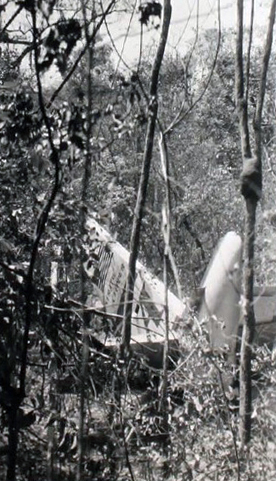
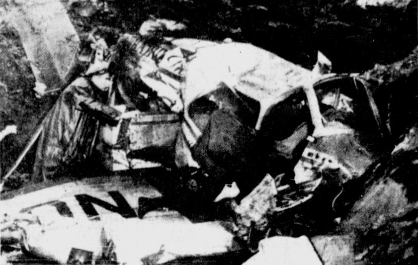
Pan American's Flight 131 departed from Bermuda at 1358, September 20, 1947, with 36 passengers and a crew of 5. The take-off and climb to the cruising altitude of 8,000 feet were normal, and the flight proceeded on course to La Guardia Field, New York, for a period of 3 hours without incident Between 1650 and 1655, about 225 statute miles from destination, Warren Robinson, the first officer, noticed a fluctuation in fuel pressure for engines 1 and 2 Seconds later, the left auxiliary fuel tank quantity gauge dropped to zero, the fuel pressure warning light flashed on, and the No 1 engine faltered To insure a positive fuel supply for all engines Mr Robinson immediately turned the fuel selector valves for all engines to their respective main tanks, 2 following which all engines operated normally. Mr Robinson then transferred fuel from the right auxiliary tank to the left auxiliary tank so that they would contain equal amounts, which was 40 gallons each according to the fuel quantity gauges after completion of the operation A few minutes later Mr Robinson noticed that the right auxiliary fuel gauge indicated not 40 gallons, but 100, and that it was visibly increasing even though no fuel was at that time being transferred The No. 3 main fuel tank gauge then dropped to zero, and the fuel pressure for the No 4 engine started to fluctuate. Alarmed by what now appeared to be a serious malfunction in the right side of the fuel system, Mr Robinson operated all engines from the left main tanks (1 and 2), turning on all the cross feed valves, and the booster pumps for main tanks 1 and 2. The flight had by this time reached position "Baker," a point on course and a distance of 212 statue miles from La Guardia This check point was regularly used by Pan American on the route from Bermuda to La Guardia, and was established by reference to precomputed radio bearings Flight Radio Officer Rea was instructed to call Captain Carl Gregg, who was eating lunch in the passengers cabin, to the cockpit. The captain, unable to account for what appeared to be a total loss of fuel in the right main tanks, tried to operate engines 3 and 4 from their respective mains. Shortly after, the fuel pressure for both these engines dropped, the fuel pressure warning lights came on, and engines 3 and 4 lost power. Other combinations of fuel valve settings were tried during the next few minutes, but power could not be restored to engines 3 and 4 The "fasten seat belt" sign was turned on, rated power was applied to engines 1 and 2, and a descent of 200 to 300 feet per minute started. Two minutes later the fire warning light flashed on for engine 4 The flight radio officer was sent to the passengers cabin to see if any signs of fire from this engine were visible He saw none from engine 4, but he did see smoke trailing from engine 3. By the time Mr Rea returned to the cockpit, Captain Gregg noticed the smell of burning rubber, and furthermore, that the fire warning light for engine 3 was also on. No flames from either engine, however, were visible. Standard fire fighting methods were followed to control the fire in the No. 3 nacelle. The propeller was feathered, all fluids into the engine were closed at the emergency shutoff valves, and the C02 gas bottle was discharged. The fire warning light then went out. Since there was no visible indication of fire in engine 4, the C02 gas bottle was not discharged. As a precautionary measure, however, the shutoff valves for all fluids into the engine were closed, and an attempt made to feather the propeller But, the propeller would not feather, and continued to windmill. At 1712, shortly after Mr. Rea transmitted to the company the flight's position as "Baker", a loud noise from the right side of the airplane was heard, and simultaneously the green right landing gear light came on. Through the drift sight the crew could see the right outboard tire burning, and a landing gear bungee cable hanging slack. All attempts to raise the right gear were unsuccessful, and it was found that with the right gear down, and with both right engines "out" that an air speed of 125 miles per hour was required to maintain directional control. At 1730, engine 4 stopped windmilling, having seized from lack of lubrication By 1745, altitude had been lost to about 1,000 feet, and over 100 statute miles remained to destination. Full take-off power was applied to engines 1 and 2 in an attempt to hold the remaining altitude. A report had been transmitted to the company at 1729 that the fires in engines 3 and 4 were believed to be out, and at 1740, the company had been advised that the flight was at 2,000 feet still descending All radio contacts with Pan American at La Guardia throughout the course of this emergency were accomplished through Eastern Air Lines' radio on the frequency 8565 kcs. Mr. Rea attempted to secure a fix on "CW" 3 from the U. S. Coast Guard, using the distress frequency of 8280 kcs. Because of an extreme amount of "CW" interference on this frequency only one station was actually contacted. This was NMR, the Coast Guard station in San Juan, Puerto Rico. Even this contact was not entirely satisfactory, and no radio bearing from it was ever received. The radio equipment was accordingly returned to the frequency of 8565 kcs, the established channel of communication, for further radiophone contact with New York. No call was ever made on the international distress frequency of 500 kcs., or over any of the "VHF" equipment on board. By 1800, altitude had been lost to 800 feet, and still over 50 statute miles remained to destination. Preparations were made for "ditching". The passengers were instructed in the use of life jackets, and in emergency water landing procedures. The life rafts were moved so as to be easily accessible from the main cabin door. Celluloid protective coverings were removed from all the emergency exit handles Clothing was loosened, and seat belts tightened. Flight Radio Officer Rea broadcasted "blind" on the frequency 8280 kcs., reporting the position of the flight to be 40-00 degrees north and 73-10 degrees west. From this point on only a small gradual loss of altitude was experienced. Captain Gregg decided to attempt to reach and land at Floyd Bennett Field, and was advised through Eastern Air Lines' radio that runway one would be available. New York Air Traffic Control had been alerted through Eastern Air Lines' radio of the emergency, and they in turn had called Coast Guard search and rescue. Coast Guard, Army, and Navy rescue equipment was dispatched, and as Flight 131 approached the coast, the crew observed other aircraft and surface vessels proceeding out to meet them. At 1815, approximately 15 statute miles from Floyd Bennett Field, the flight had descended to an altitude of 400 feet. Full available power was now applied to engines 1 and 2, and the flight was able to not only hold, but even gain a slight amount of altitude, Four to five minutes later, 1820, throttles were retarded to take-off power and the aircraft maneuvered into a position for a straight-in landing approach on runway one. The aircraft was set down 775 feet from the south end of runway one, wheels up. During the course of the crash landing the No. 1 propeller was torn from the engine, the propeller dome becoming embedded in the No. 2 main fuel tank. The spilled gasoline was ignited by sparks generated as the aircraft skidded 2,167 feet on the concrete runway to a stop U. S. Navy fire and crash equipment had been previously deployed along runway one which allowed the Navy's crash personnel to bring the fire quickly under control, and to assist the passengers and crew to deplane without injury.
Probable cause:
The Board determines that the probable cause of this accident was electrical arcing between the battery "bus" and an engine control pulley bracket in the No 3 engine nacelle. This arcing resulted from the lack of adequate protection for the "bus."
Final Report: