Crash of a Cessna 402C in Lewisville: 1 killed

Date & Time: Dec 4, 2002 at 0616 LT
Type of aircraft:
Registration:
N402ME
Flight Phase:
Flight Type:
Survivors:
No
Schedule:
Denton - Dallas
MSN:
402C-0010
YOM:
1979
Crew on board:
1
Crew fatalities:
Pax on board:
0
Pax fatalities:
Other fatalities:
Total fatalities:
1
Captain / Total flying hours:
1290
Aircraft flight hours:
16464
Circumstances:
The twin-engine airplane impacted the ground during an uncontrolled descent while maneuvering in dark night instrument meteorological conditions in the vicinity of Lewisville, Texas. The commercial pilot contacted the approach controller and stated that his attitude indicator was "not helping" and needed "a little bit of help with trying to keep it straight." The pilot was instructed by approach control to maintain an altitude of 3,000 feet msl. The approach controller confirmed with the pilot that he could not fly headings, and instructed the pilot to turn right. Seconds afterwards, the pilot was instructed to turn left and the controller would tell him when to stop the turn. The pilot acknowledged. There were no further communications between the pilot and air traffic control. The airplane initially impacted in a near vertical attitude into a wooded area adjacent to a rural paved road, slid across the road, and impacted a residence. Radar data showed that the airplane's magnetic heading was erratic throughout the 5-minute flight. The gyro instruments found at the accident site were the copilot's direction gyro (vacuum), a turn and bank indicator (electric), and the pilot's attitude indicator (vacuum). The gyros were disassembled, and visually examined. The co-pilot's direction gyro examination revealed rotation signatures on the gyro and the gyro housing. The turn and bank indicator revealed a "faint" rotational signature on the gyro. The pilot's attitude indicator gyro had no rotational signatures, and exhibited blunt impressions corresponding to the gyro buckets on the inside of the gyro-housing wall. A maintenance repair data plate ("Functional Tested") was found on the attitude indicator's instrument housing dated 12/2/02. Due to the extent of the fire damage, no instrument readings could be obtained. Seven days prior to the accident flight, a company pilot who flew the accident airplane reported that the pilot's attitude indicator (part number 102-0041-04, serial number 92B0346) "rotated" and the flight was aborted. The next day, the attitude indicator was removed and bench checked, cleaned, and adjusted. The attitude indicator was reinstalled and an operational check on the ground was performed. Three days prior to the accident the pilot's attitude indicator was again removed for an overhaul. According to company maintenance personnel, the attitude indicator was reinstalled the night prior to the morning of the accident, and an operational check on the ground was performed. Radar data showed that the aircraft did not stabilize on a particular heading throughout the flight. Physical evidence showed that the pilot's attitude gyro was not "spooled" at the time of impact.
Probable cause:
The failure of the attitude indicator, and the pilot's failure to maintain aircraft control as a result of spatial disorientation following the failure of the attitude indicator. Contributing factors were a low ceiling, clouds, and dark night conditions.
Final Report:

Crash of a Cessna 421C Golden Eagle III near Tajique: 1 killed

Date & Time: Dec 3, 2002 at 2035 LT
Registration:
N3855C
Flight Phase:
Flight Type:
Survivors:
No
Site:
Schedule:
Alamogordo – Albuquerque
MSN:
421C-0121
YOM:
1976
Crew on board:
1
Crew fatalities:
Pax on board:
0
Pax fatalities:
Other fatalities:
Total fatalities:
1
Captain / Total flying hours:
2500
Aircraft flight hours:
8539
Circumstances:
Prior to departing on the first leg of the flight, the dispatcher advised the pilot that he needed him to check the weather. After advising the pilot that he would be flying an additional leg, the
dispatcher again advised the pilot that he needed him to check the weather, which the pilot did, as observed by the dispatcher. After reaching 14,500 feet at 2028 the pilot contacted Albuquerque Approach Control, advising the controller that he had information "Yankee" and was requesting a lower altitude. The controller instructed the pilot to proceed via his own navigation and to descend at pilot's discretion. The pilot replied "Roger." From 2034 to 2041 the controller made four attempts to contact the pilot, each without success. At 2039 and 2042 the controller asked two other aircraft in the area to try establishing radio communication with the pilot; neither were successful. At 2033:19 the last radar return with altitude information was received from the aircraft, with a reported altitude of 10,200 feet MSL. A primary radar contact, with no transponder or altitude information, was received at 2033:32, 2.2 nautical miles southeast of the accident site, putting it on a straight line between the last radar contact and destination airport. The accident site was located at the 9,012 foot level of a mountain range, 19 nautical miles southeast of the destination airport. Post-accident examination revealed no anomalies with the airframe or engines which would have prevented normal operations. At 1956, the weather observation facility located at the destination airport reported a few clouds at 800 feet, scattered clouds at 2,500 feet, and overcast clouds at 4,200 feet. The remarks section stated rain ended at 35 minutes past the hour, and mountains obscured northeast to southeast. At 2024, the same weather facility reported scattered clouds at 600 feet and overcast clouds at 4,200 feet.
Probable cause:
The pilot's failure to maintain terrain clearance. Factors contributing to the accident were the high mountains, mountain obscuration, the dark night condition, and the pilot's improper inflight planning/decision making.
Final Report:

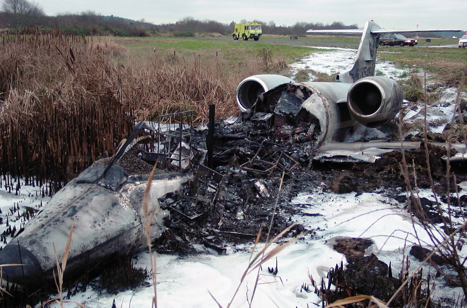
Crash of a Learjet 36A in Astoria

Date & Time: Dec 3, 2002 at 0612 LT
Type of aircraft:
Operator:
Registration:
N546PA
Flight Phase:
Flight Type:
Survivors:
Yes
Schedule:
Astoria - Astoria
MSN:
36-045
YOM:
1980
Location:
Crew on board:
2
Crew fatalities:
Pax on board:
2
Pax fatalities:
Other fatalities:
Total fatalities:
0
Captain / Total flying hours:
3350
Captain / Total hours on type:
2350.00
Copilot / Total flying hours:
1170
Copilot / Total hours on type:
920
Aircraft flight hours:
12335
Circumstances:
The pilot (PIC) reported that during acceleration for takeoff (approximately V1 [takeoff decision speed]) the airplane collided with an elk. The PIC reported that after the collision, he applied wheel brakes and deployed the airplane's drag chute, however, the airplane continued off the departure end of the runway. The airplane came to rest in a marshy bog approximately 50 feet beyond the departure threshold. Currently, approximately 15,000 feet of the airport's perimeter is bordered with animal control fence. The airport recently received a FAA Aviation Improvement Program (AIP) Grant that will provide funding for an additional 9,000-feet of fence. Airport officials stated that the fencing project should be completed by summer of 2003. At the completion of the project, game control fencing will encompass the entire airport perimeter. The U.S. Government Airport/Facilities Directory (A/FD) contains the following remarks for the Astoria Regional Airport: "Herds of elk on and in the vicinity of airport..."
Probable cause:
Collision with an elk during the takeoff roll. Factors include dark night VFR conditions.
Final Report:

Crash of an IAI 1124A Westwind II in Taos: 2 killed

Date & Time: Nov 8, 2002 at 1457 LT
Type of aircraft:
Operator:
Registration:
N61RS
Flight Type:
Survivors:
No
Schedule:
Las Vegas - Taos
MSN:
384
YOM:
1983
Location:
Crew on board:
2
Crew fatalities:
Pax on board:
0
Pax fatalities:
Other fatalities:
Total fatalities:
2
Captain / Total flying hours:
5251
Captain / Total hours on type:
877.00
Copilot / Total flying hours:
14234
Copilot / Total hours on type:
682
Aircraft flight hours:
3428
Circumstances:
After passing the initial approach fix, during an instrument approach to the destination airport, radar and radio contact were lost with the business jet. One witness reported hearing "distressed engine noises overhead," and looked up and saw what appeared to be a small private jet flying overhead. The engine seemed to be "cutting in and out." The witness further reported observing the airplane in a left descending turn until his view was blocked by a ridge. The witness then heard an explosion and saw a big cloud of smoke rising over the ridge. A second witness heard a loud noise and looked up and saw a small white airplane with two engines. The witness stated that the airplane started to turn left with the nose of the airplane slightly pointing toward the ground. The airplane appeared to be trying to land on a road. A third witness heard the roar of the airplane's engines, and looked toward the noise and observed the airplane in a vertical descent (nose dive) impact the ground. The witness "heard the engines all the way to the ground." Examination of the airframe and engines did not disclose any structural or mechanical anomalies that would have prevented normal operation. The National Weather Service had issued a SIGMET for severe turbulence and mountain wave activity. Satellite images depicted bands of altocumulus undulates and/or rotor clouds over the accident site.
Probable cause:
The pilot's inadvertent flight into mountain wave weather conditions while IMC, resulting in a loss of aircraft control.
Final Report:

Crash of a Cessna 208B Grand Caravan in Parks: 4 killed

Date & Time: Nov 8, 2002 at 1020 LT
Type of aircraft:
Registration:
N514DB
Flight Phase:
Flight Type:
Survivors:
No
Schedule:
Las Vegas - Midland
MSN:
208B-0971
YOM:
2002
Location:
Crew on board:
2
Crew fatalities:
Pax on board:
2
Pax fatalities:
Other fatalities:
Total fatalities:
4
Captain / Total flying hours:
1880
Captain / Total hours on type:
77.00
Copilot / Total flying hours:
638
Circumstances:
The airplane departed Las Vegas, Nevada, approximately 0919, on an IFR flight plan to Midland, Texas. The pilot climbed to an initial cruising altitude of 13,000 feet. At 1005, the pilot contacted Albuquerque ARTCC (ZAB) and reported that he was level at 13,000 feet. At 1009, the pilot requested to climb to 15,000 and the ZAB controller approved the request. At 1013:55, the pilot contacted Albuquerque Flight Watch and reported that he was approximately 23 miles west of Flagstaff, Arizona at 15,000 feet, and that about 20 miles west of his position, at 13,000 feet, he encountered "light mixed icing." The pilot requested any PIREP's. Flight Watch reported that a PIREP for "a trace of rime icing at 12,000," was reported by an airplane climbing westbound out of Albuquerque. The pilot acknowledged and asked for the weather across New Mexico. Flight Watch advised the pilot to stand by while he gathered the reports. At 1015:15, the pilot contacted ZAB. He reported, "getting...mixed...right...now," and requested to climb to 17,000 feet. At 1015:57 the controller cleared the airplane to 17,000 feet. At 1016:35, the FW specialist repeated the report of trace icing near Albuquerque. The pilot did not reply. ZAB radar indicated the airplane climbed to 15,200 feet then entered a rapid descent. At 1017:08, a broken transmission was received. No further communications were received from the airplane. Radar contact was lost with the airplane at 1017:20. An examination of the airplane wreckage showed no anomalies.
Probable cause:
The pilot's improper in flight planning/decision making, his flight into known icing conditions, and his failure to maintain adequate airspeed which resulted in the inadvertent stall/spin and impact with terrain. Factors contributing to the accident were the pilot's improper pre-flight planning/preparation, the icing conditions, and the inadvertent stall/spin.
Final Report: