Crash of a Mitsubishi MU-2B-30 Marquise in Bathurst: 1 killed

Date & Time: Nov 7, 1990
Type of aircraft:
Registration:
VH-WMU
Flight Type:
Survivors:
No
Schedule:
Bankstown - Bathurst
MSN:
512
YOM:
1970
Country:
Region:
Crew on board:
1
Crew fatalities:
Pax on board:
0
Pax fatalities:
Other fatalities:
Total fatalities:
1
Circumstances:
Crashed on approach in foggy conditions while performing a cargo flight from Bankstown with bank notes on board. The pilot, sole on board, was killed.

Crash of a Beechcraft E90 King Air in Wondai: 5 killed

Date & Time: Jul 26, 1990 at 2248 LT
Type of aircraft:
Operator:
Registration:
VH-LFH
Flight Phase:
Flight Type:
Survivors:
Yes
Schedule:
Cairns – Wondai – Camden
MSN:
LW-255
YOM:
1978
Country:
Region:
Crew on board:
1
Crew fatalities:
Pax on board:
5
Pax fatalities:
Other fatalities:
Total fatalities:
5
Captain / Total flying hours:
2654
Captain / Total hours on type:
285.00
Circumstances:
Beech E90 VH-LFH was being flown by the owner as pilot-in-command for the flight. The pilot had submitted a flight plan nominating a private category, single pilot, instrument flight rules (IFR) flight, from Cairns to Wondai and thence to Camden. VH-LFH, with six passengers on board, departed Cairns at 1830 hours EST and arrived at Wondai at 2142 hours after an uneventful flight. One passenger left the aircraft at Wondai. The aircraft was refuelled with 800 litres of aviation turbine fuel and the pilot reported taxying for Runway 36 at Wondai to Brisbane Flight Service at 2243 hours EST. The aircraft was issued an airways clearance at 2245 hours which the pilot acknowledged correctly. The last radio contact with the aircraft was at 2248 hours when the pilot reported airborne. Witnesses observed the aircraft take-off and a short time later heard the sound of impact. The aircraft struck a line of small trees slightly left of the runway extended centreline and 600 metres from the end of the runway in a wings level attitude and in a very shallow descent. Forty-eight metres beyond this point, the aircraft impacted the ground and began to break up. It then contacted a number of large trees and caught fire, finally coming to rest 90 metres further on. A passenger was seriously injured while five other occupants were killed.
Probable cause:
The circumstances leading to the development of this accident could not be established conclusively. However, the evidence supports the following as probable factors:
- The pilot might not have been aware of the human factors aspects associated with dark night take-offs.
- The pilot could have been influenced by stress and/or fatigue.
- The aircraft was taking off towards dark textureless terrain and no visible horizon.
- By transmitting his airborne call very soon after lift-off, the pilot was not devoting his full attention to flying the aircraft.
- The pilot became disoriented and placed the aircraft in a shallow descent as it accelerated after take-off.
Final Report:

Crash of a Pilatus PC-6/B1-H2 Turbo Porter in Goombungee

Date & Time: Jul 17, 1990
Operator:
Registration:
A14-704
Flight Phase:
Flight Type:
Survivors:
Yes
MSN:
730
YOM:
1971
Country:
Region:
Crew on board:
1
Crew fatalities:
Pax on board:
0
Pax fatalities:
Other fatalities:
Total fatalities:
0
Circumstances:
Crashed in unknown circumstances in an open field located in Goombungee while engaged in a training flight. The pilot, sole on board, escaped with minor injuries.

Crash of a Cessna 500 Citation near Mareeba: 11 killed

Date & Time: May 11, 1990 at 1740 LT
Type of aircraft:
Operator:
Registration:
VH-ANQ
Survivors:
No
Site:
Schedule:
Proserpine – Mareeba – Cairns
MSN:
500-0283
YOM:
1975
Country:
Region:
Crew on board:
1
Crew fatalities:
Pax on board:
10
Pax fatalities:
Other fatalities:
Total fatalities:
11
Captain / Total flying hours:
14150
Captain / Total hours on type:
1000.00
Circumstances:
Cessna 500 VH-ANQ was operating the Proserpine to Mareeba leg of a charter flight The aircraft departed Proserpine at 16:35 hours. The charter flight had been organised to transport members of five local government authorities from the Cairns/Atherton Tablelands area to a Local Government Association Conference at Airlie Beach, Queensland. The flight plan indicated that the flight would follow Instrument Flight Rules (IFR) with a planned cruising altitude of FL330. The aircraft was planned to track via overhead Townsville then direct to Mareeba with a flight time interval of 68 minutes. The flight apparently continued normally and at 17:26 the aircraft was cleared to descend to FL170 and instructed to call Cairns Approach. On first contact with Cairns Approach, the pilot advised that the aircraft was tracking for Mareeba via the 163 radial at 41 miles (76 kilometres) DME from Biboohra. (There are no radio navigational aids at Mareeba, the nearest aids for tracking and instrument approach purposes are at Biboohra, about 16 kilometres north of Mareeba). The aircraft was advised to maintain FL170 but a short time later was cleared to descend to FL120. The pilot stated that he would not be closing down the engines at Mareeba and that his estimated departure time was 17:50. At 17:35 hours VH-ANQ was cleared to descend to 10,000 feet and one minute later the pilot advised that the aircraft was "approaching over Mareeba and visual". Cairns Approach advised VH-ANQ that there would be a short delay at 10,000 feet and following a request from the pilot gave approval for the aircraft to circle over Mareeba. At 17:40 hours, Cairns Approach instructed the aircraft to descend to 7,000 feet. This transmission, and other subsequent transmissions to the aircraft, went unanswered. The wreckage of VH-ANQ was ultimately located on the eastern slopes of Mt Emerald, 15 kilometres south of Mareeba Airport, by searching helicopters at 0240 hours on 12 May 1990. The aircraft initially impacted the mountainside with the left wingtip, while travelling on a track of about 340 degrees Magnetic. At the time it was in a wings level attitude at an angle of descent of eight degrees. It then struck the ground just below the apex of a ridge and the wreckage spread in a fan shape, at an angle of 30 degrees, along a centreline track of 350 degrees Magnetic.
Probable cause:
This accident was unusual in that the last report by the pilot indicated that the aircraft was at 10,000 feet and on a track that was 55 kilometres to the east of the accident site. There was no substantiated, and very little circumstantial evidence to suggest what caused the aircraft to descend 6,400 feet and to be displaced a considerable distance to the west of track. As a result the causal factors associated with this accident remain undetermined.
Final Report:

Crash of a Cessna 501 Citation I/SP in Lord Howe Island

Date & Time: Apr 22, 1990 at 1225 LT
Type of aircraft:
Operator:
Registration:
VH-LCL
Flight Type:
Survivors:
Yes
Schedule:
Sydney - Lord Howe
MSN:
501-0145
YOM:
1979
Country:
Region:
Crew on board:
2
Crew fatalities:
Pax on board:
6
Pax fatalities:
Other fatalities:
Total fatalities:
0
Circumstances:
The aircraft was being used for a pleasure flight for the owner and some friends. The Captain calculated the landing distances required for both runway 28 and 10, based on weather reports obtained at briefing, which indicated a strong northerly wind component. An updated report received some 30 minutes before descent confirmed the wind as 290 degrees at 7 knots. Approaching the island and becoming visual, the crew noted the windsock near the western end of the runway to be indicating a slight headwind component in the 10 direction and decided on a straight in approach to runway 10, to avoid an approaching squall/shower. The aircraft touched down firmly a short distance beyond the threshold. Speed brakes were immediately extended and wheel braking applied. About four seconds later the Captain called for the drag chute to be deployed. Although the co-pilot correctly activated the handle, it became obvious that the chute had not deployed as no increase in retardation occurred. When the Captain realised that the aircraft could not be stopped on the runway remaining he attempted to turn the aircraft towards a clear grass area to the right. However, the aircraft was aquaplaning on the wet surface and did not respond to steering inputs for some distance. The aircraft left the bitumen tracking to the right. It collided with a gable marker, passed through a fence, continued down an embankment, across a road, through a second fence and came to rest approximately 90 metres from the runway end and 70 metres to the right of the extended centreline. The left main and nose gear legs were torn off. Witnesses to the accident said that when the aircraft landed, the runway was very wet and the wind was westerly at 5 to 10 knots.
Probable cause:
It was determined that the Captain had made some miscalculations in his pre-flight assessments. He had noted the landing distance available as being the same for both runways, whereas runway 28 has a reduced length due to terrain clearance requirements on the approach. Under the conditions both forecast and prevailing, and using the criteria applicable at the time for an aircraft fitted with an alternate means of retardation, i.e. drag chute, the landing distances required for both runways were greater than the landing distances available. The Captain had also evidently applied incorrect techniques during the landing. He had not attempted to deploy the drag chute immediately the nose wheel was on the ground, and had not applied unmodulated pressure to the anti-skid braking system. These measures are required by the manufacturer to obtain maximum performance. It was found that the drag chute canister lid had been sealed with tank sealant and painted over. The latch assembly had operated but the drogue chute spring was insufficiently strong to break the seal. When the sealant was prised away from around the lid, the system operated normally. This error had not been found during a check of the aircraft immediately following repainting. The lid had the appearance of an oblong radio antenna and was not marked in any distinguishing manner. The problem should also have been noticed during a subsequent inspection of the drag chute for moisture. The inspection is required every 90 days if the drag chute has
not been deployed, and requires the removal of the lid and drogue chute in order to feel the main chute for moisture. The condition of the sealant would indicate that this had not been carried out.
The following factors were considered relevant to the development of the accident:
- Inadequate pre-flight planning and preparation by the flight crew. The runway distance required was in excess of the distance available on either runway.
- Adverse runway and weather conditions - wet surface and downwind component.
- Improper sealing of drag chute canister.
- Inadequate maintenance of the drag chute system.
- Improper operation of wheel brakes.
Final Report:

Crash of a GAF Nomad N.22B in Leongatha

Date & Time: Apr 5, 1990 at 0645 LT
Type of aircraft:
Registration:
VH-DNM
Flight Phase:
Flight Type:
Survivors:
Yes
Schedule:
Leongatha - Leongatha
MSN:
25
YOM:
1976
Country:
Region:
Crew on board:
1
Crew fatalities:
Pax on board:
0
Pax fatalities:
Other fatalities:
Total fatalities:
0
Circumstances:
On completion of temporary repairs following a forced landing accident in a paddock, a permit to fly was issued authorising a ferry flight from the accident site to a nearby strip. During the take off roll the pilot was unable to maintain directional control and the aircraft crossed a drain before striking a fence and overturning. An inspection of the aircraft did not reveal any defect which could have contributed to the loss of directional control. Following the landing accident the property owner had rotary-hoed the paddock to a depth of 10 centimetres. Using a motor vehicle, the pilot compacted a 2.5 metre wide strip along the centreline of the paddock, which sloped approximately 3 degrees down to the north. At the time of the takeoff to the north the wind was from the north-east at 5 knots. The pilot selected a takeoff power setting of 53 percent of the maximum power available which effectively increased the take off ground roll required by approximately 170 metres.
Probable cause:
The investigation revealed that after a 50 metre ground roll the left main wheel entered the rotary-hoed area. The aircraft then veered further to the left before striking the fence and overturning.
The following factors were considered relevant to the development of the accident:
- The strip width was inadequate for the safe operation of the aircraft.
- The pilot did not maintain directional control during the take-off.
- The pilot delayed abandoning the take-off.
Final Report:

Crash of a GAF Nomad N.24A at Edinburgh AFB: 1 killed

Date & Time: Mar 12, 1990
Type of aircraft:
Operator:
Registration:
A18-401
Flight Type:
Survivors:
No
Schedule:
Edinburgh AFB - Edinburgh AFB
MSN:
128
YOM:
1982
Country:
Region:
Crew on board:
1
Crew fatalities:
Pax on board:
0
Pax fatalities:
Other fatalities:
Total fatalities:
1
Aircraft flight hours:
300
Circumstances:
The pilot, sole on board, was completing a local training flight at Edinburgh AFB. On approach, the tail separated and the aircraft dove into the ground and crashed near the airfield. The aircraft was destroyed and the pilot F/Lt Glenn Kemshall Donovan was killed.
Probable cause:
After being manufactured in 1982, the airplane was used by GAF (renamed Aerospace Technologies of Australia - ASTA in 1987) for testing. Amongst others, service records indicated 177 hours of single engine ground running. This meant that the airplane was subjected to many high frequency asymmetric cycles. Cracks initiated and grew predominately due to torsional loading. Upon delivery to the RAAF, the airplane was inspected but this failed to detect significant cracking. The tailplane centre section failed in flight, 19 hours after the inspection.

Crash of a Mitsubishi MU-2B-60 Marquise near Meekatharra: 2 killed

Date & Time: Jan 26, 1990 at 0105 LT
Type of aircraft:
Registration:
VH-MUA
Flight Phase:
Survivors:
No
Schedule:
Perth - Port Hedland
MSN:
746
YOM:
1979
Country:
Region:
Crew on board:
1
Crew fatalities:
Pax on board:
1
Pax fatalities:
Other fatalities:
Total fatalities:
2
Captain / Total flying hours:
11030
Captain / Total hours on type:
51.00
Aircraft flight hours:
1902
Circumstances:
The aircraft had been chartered for a flight from Perth to Port Hedland. The pilot arrived at the aircraft at 2210 hours on 25 January, and after a short inspection of the aircraft, attended the CAA flight planning office for air traffic control and meteorology briefing. The briefing included information about a tropical cyclone off the NW coast of Australia and its potential effects on the proposed flight. After the flight plan was submitted, the pilot returned to the aircraft at 2315 hours as the loading was being completed, and conducted a preflight inspection of the aircraft and its load. The aircraft departed Perth at 2339 and commenced a climb towards Ballidu, the first turning point, over which it passed at 0003 hours. Subsequently, the aircraft passed over Mt Singleton at 0020, Mt Magnet at 0040 and Meekatharra at 0102 hours. After Ballidu, the aircraft climbed from FL170 to FL190 and climbed further to FL210 after Mt Magnet. While over Meekatharra, the passenger (also a licenced pilot) gave the position report. One minute later, the pilot radioed that the aircraft was out of control and descending. He called again 30 seconds later and advised that the aircraft was in ice and spinning down through 8,000 feet. No further communications were received from the aircraft. Both occupants were killed.
Probable cause:
The following findings were reported:
- The pilot did not have recent experience in high-performance, high-altitude aircraft except for the 51.7 hours gained in the MU-2.
- The pilot did not possess some of the experience levels and recency requirements placed on MU-2 pilots immediately after the accident by the CAA.
- The pilot did not take sufficient account of the operational characteristics of this aircraft type.
- The pilot's situational awareness was probably impaired during the flight, because of the combination of pre-existing cumulative fatigue, and insufficient sleep in the previous 42 hours.
- The meteorological conditions were conducive to the formation of airframe icing on an aircraft flying in cloud along the flight planned route.
- It is probable that control was lost as the aircraft banked to the left over Meekatharra, to change track towards Port Hedland.
- The pilot reported that the aircraft was in ice during his last radio transmission.
- The pilot was unable to recover from the spin before the aircraft hit the ground.
Final Report:

Crash of a Fletcher FU24-950 in Frogmore: 1 killed

Date & Time: Nov 29, 1989 at 1150 LT
Type of aircraft:
Operator:
Registration:
VH-HTB
Flight Phase:
Survivors:
No
Schedule:
Frogmore - Frogmore
MSN:
174
YOM:
1971
Country:
Region:
Crew on board:
1
Crew fatalities:
Pax on board:
0
Pax fatalities:
Other fatalities:
Total fatalities:
1
Circumstances:
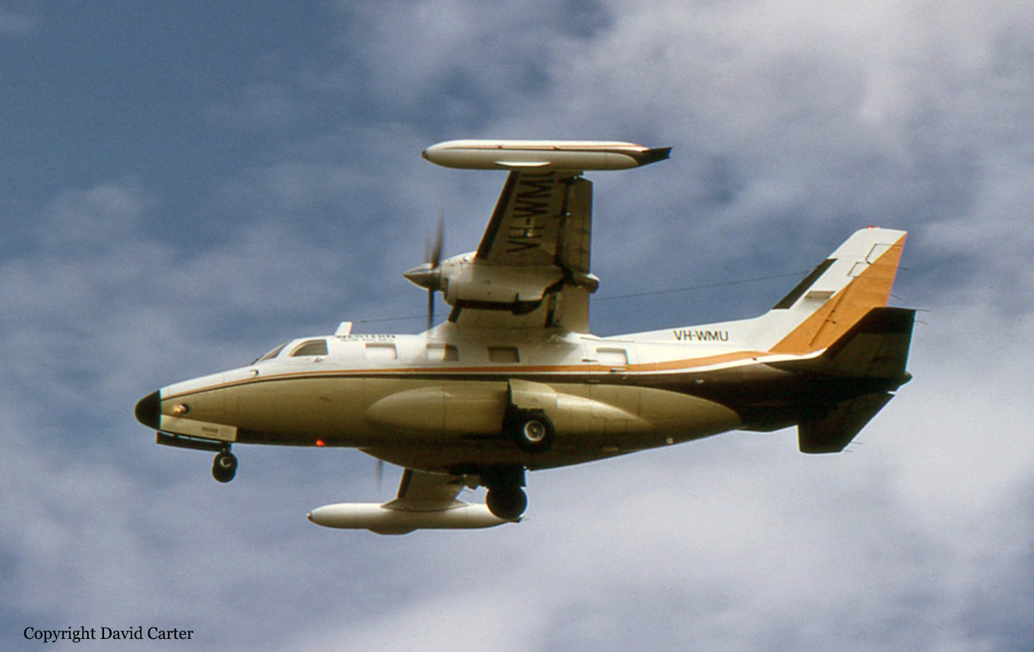
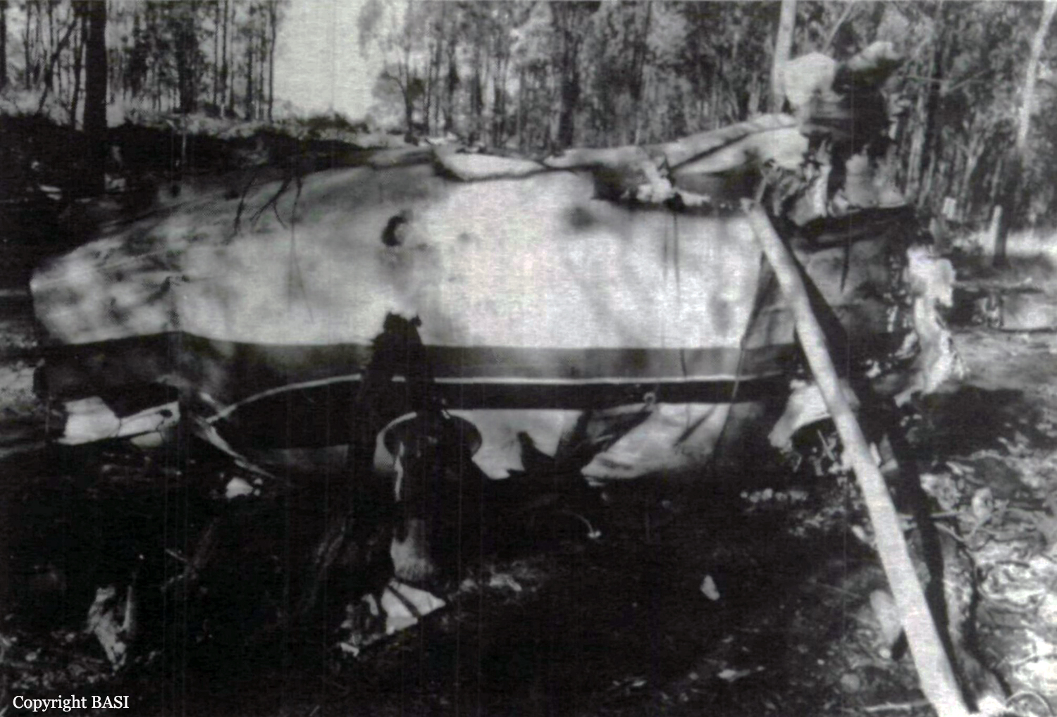
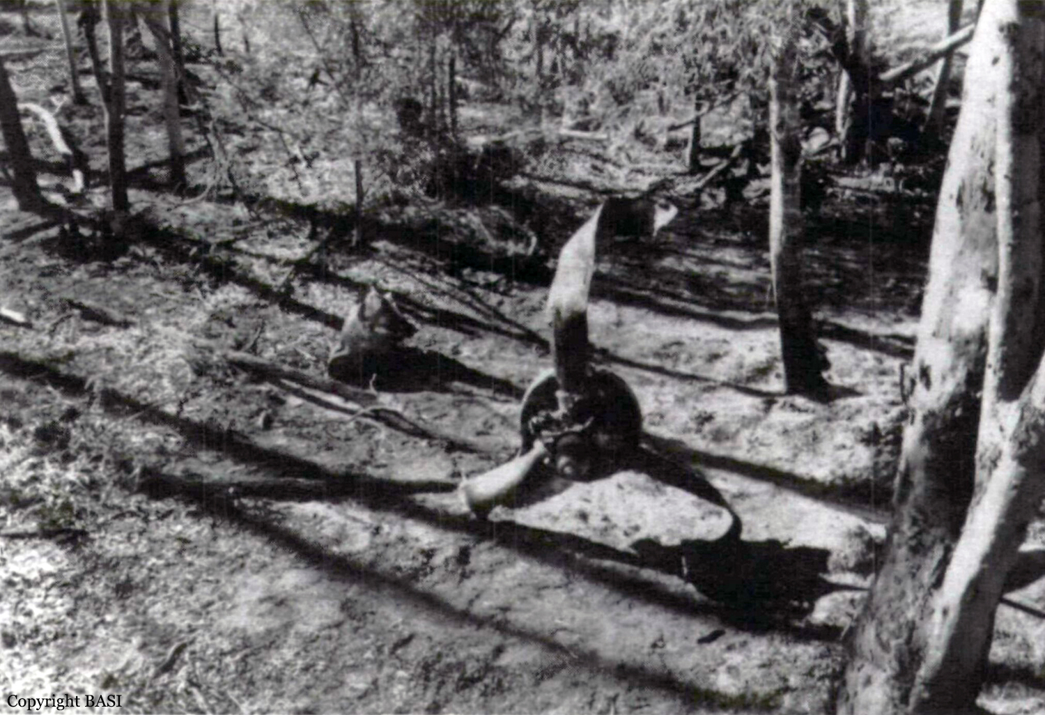
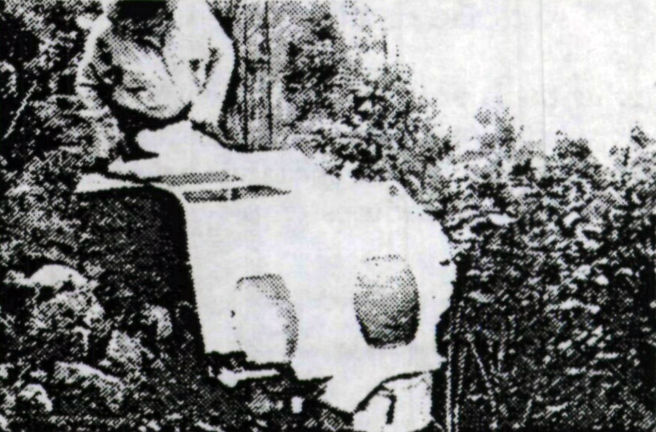
The aircraft was engaged in superphosphate spreading operations. An aerial survey of the property had been conducted by the pilot in company with the property owner. Power poles in the valley ahead and to the left of the airstrip were marked. When operations started the wind was a light north-easterly and ambient temperature was 16° Celsius. By the time the aircraft had refuelled and was ready for the thirty-sixth flight of the day, the ambient temperature had increased to 28° Celsius and the wind direction had changed to a south-westerly. Shortly after takeoff, the aircraft was observed to sink after overflying the high-voltage power lines between the marked poles. On the next flight the aircraft was observed to make a tight left turn and fly down the valley adjacent to the left marked powerpole. On the next and final flight, the aircraft was apparently attempting to follow the track of the previous flight. While crossing the power lines south-west of the marked power pole, the aircraft's landing gear and left wing tip struck the powerlines. With the broken powerline jammed behind the left aileron washout plate, the aircraft impacted the ground 100 metres beyond the powerpole. Ground impact forces destroyed the aircraft and reduced the cockpit area to non-survivable dimensions.
Probable cause:
On-site examination of the aircraft and subsequent laboratory examination and testing of components did not reveal any pre-existing mechanical defects or abnormalities which could be considered as factors in, or contributory to, this accident. Powerline impact marks on the aircraft were consistent with the aircraft being in a left banked attitude when it struck the wire. The investigation revealed that the loader driver's truck bucket load gauge had no conversion/calibration chart, and that the aircraft was being operated in excess of the maximum allowable weight for takeoff. It is considered probable that the pilot had elected to fly down the valley, (thus taking advantage of the downslope), to compensate for a degradation of aircraft performance whilst operating overweight in the changed ambient conditions. The absence of a superphosphate trail before wire impact indicates that the pilot did not dump any of the load and was either unaware
of, or had forgotten about, the existence of powerlines to the south-west of the marked powerpole.
The following factors were considered relevant to the development of the accident:
1. The aircraft was being operated in an overweight configuration for takeoff.
2. The pilot did not adjust the takeoff weight of the aircraft to give an acceptable climb performance.
3. The pilot was unaware of, or had forgotten about, the powerlines to the south-west of the marked pole; or,
4. the pilot misjudged the clearance between the powerlines and the aircraft whilst trying to overfly them.
Final Report:

Crash of a Rockwell 500U Shrike Commander on Mt Barren Jack: 2 killed

Date & Time: Nov 18, 1989 at 1241 LT
Operator:
Registration:
VH-BMR
Flight Phase:
Survivors:
No
Site:
Schedule:
Canberra – Dalby
MSN:
500-1754-45
YOM:
1968
Country:
Region:
Crew on board:
2
Crew fatalities:
Pax on board:
0
Pax fatalities:
Other fatalities:
Total fatalities:
2
Circumstances:
When the survey aircraft failed to arrive at the destination, and on expiry of the SAR time, a search was commenced. Wreckage of the aircraft was subsequently found on the eastern slope of Mt Barren Jack, to the north west of the mouth of Carrolls Creek, and on the planned track for the survey operation. Observers at the Burrinjuck reservoir near the mouth of Carrolls Creek described the weather in the accident area at the time as black clouds spilling over and obscuring the mountain tops. The aircraft collided with trees on the side of the mountain, while banked steeply to the right and in a tail low attitude. The pilot was thrown from the aircraft during the impact sequence. Medical opinion held that there was no evidence of body trauma consistent with the seat belt being fastened at the time of impact. The flight was completed on behalf of the Bureau of Mineral Resources (BMR) and both occupants were killed.
Probable cause:
Because of the destruction of the aircraft by the ensuing fire the status of the seat belt assemblies were unable to be determined. The investigation revealed that both engines were operating at high power at the time of impact. No malfunction or defect could be found with the aircraft which could have contributed to the accident. The survey task required the pilot to adhere strictly to a particular track and the target height for the flight was 500 feet above ground level while maintaining visual contact with the ground at all times. The pilot was suitably qualified to act as pilot in command of survey operations down to a height of 200 feet above ground level. The investigation concluded that the aircraft was being operated at a height substantially lower that 500 feet above ground level prior to the accident. Impact marks, wreckage and mechanical evidence suggest that the aircraft impacted terrain at a time when the pilot was attempting to carry out an evasive manoeuvre to remain clear of terrain. The reason why the aircraft was being operated at such a height and why the pilot delayed turning away from the steeply rising terrain could not be determined.
The following factors were reported:
- The pilot continued the flight into adverse weather conditions.
- The pilot flew the aircraft towards steeply rising terrain at a height substantially lower that 500 feet above ground level.
Final Report: