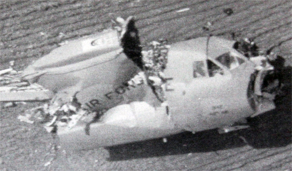
Crash of a Beechcraft B100 King Air in Miles City

Date & Time: Jan 4, 1996 at 0745 LT
Type of aircraft:
Registration:
N924WS
Survivors:
Yes
Schedule:
Billings - Miles City
MSN:
BE-63
YOM:
1978
Crew on board:
2
Crew fatalities:
Pax on board:
3
Pax fatalities:
Other fatalities:
Total fatalities:
0
Captain / Total flying hours:
5251
Captain / Total hours on type:
125.00
Aircraft flight hours:
9449
Circumstances:
The pilots obtained a complete weather briefing for their IFR flight. Before landing at their destination, they attempted to obtain an airport advisory on Unicom, but received no response. They landed on the runway in low visibility with the runway lights visible. After touchdown, the left main landing gear contacted a berm or snowbank on the left side of the plowed area, and the pilots were unable to maintain directional control. The aircraft drifted off the left side of the runway and came to rest on a reverse heading. The runway, which was 100 feet in width, had been plowed to about 45.5 feet width along the centerline. No notams had been filed concerning the partially plowed condition of the runway. The second officer (commercial pilot) noted that during the weather briefing, the pilot-in-command had been advised of thin, loose snow on the runway.
Probable cause:
Failure of airport personnel to properly remove snow from the runway or issue an appropriate notam concerning the runway condition. Factors relating to the accident were: the low light condition at dawn, and the snowbank or berm that was left on the runway.
Final Report:

Crash of a Beechcraft E18S in Butte: 1 killed

Date & Time: Jan 26, 1995 at 2230 LT
Type of aircraft:
Operator:
Registration:
N250RP
Flight Type:
Survivors:
No
Schedule:
Seattle - Missoula
MSN:
BA-47
YOM:
1955
Flight number:
MER035
Location:
Crew on board:
1
Crew fatalities:
Pax on board:
0
Pax fatalities:
Other fatalities:
Total fatalities:
1
Captain / Total flying hours:
14575
Captain / Total hours on type:
2806.00
Aircraft flight hours:
15043
Circumstances:
While performing an ILS approach at night and in IMC, the airplane collided with trees in mountainous terrain prior to the IAF. The MDA prior to the IAF is 10,600 feet. The descent altitude at the outer marker is 7,713 feet. The wreckage was located under the localizer path at an elevation of 7,600 feet. Damage to tree tops along the wreckage distribution path indicates that the airplane travelled through the trees on a level plane until contact with the ground approximately 300 feet into the path. Light snow was falling at the time of the accident and visibility was deteriorating due to fog. During the post crash investigation, there was no evidence found to indicate a mechanical failure or malfunction.
Probable cause:
The pilot's failure to follow the ifr procedure by not maintaining the proper altitude prior to the initial approach fix. Factors to the accident were dark night conditions and a low ceiling.
Final Report:

Crash of a Piper PA-31T Cheyenne I in Brockway: 2 killed

Date & Time: Nov 29, 1994 at 1950 LT
Type of aircraft:
Registration:
N22CN
Flight Phase:
Survivors:
No
Schedule:
La Crosse - Kalispell
MSN:
31-7904049
YOM:
1979
Crew on board:
1
Crew fatalities:
Pax on board:
1
Pax fatalities:
Other fatalities:
Total fatalities:
2
Captain / Total flying hours:
1200
Captain / Total hours on type:
170.00
Circumstances:
The airplane was level at FL220 at night when vertical fluctuations in altitude up to 500 feet above altitude were noted by the Salt Lake Center controller. Immediately thereafter, the aircraft began a descent and transponder targets were lost. A trajectory study showed the aircraft descending in a tight right turn. Examination of the wreckage revealed that the right elevator separated in negative overload with both wings separating negatively. Wreckage distribution established separation of the empennage and its associated control surfaces before the separation of the wings. A preimpact fire was witnessed and the main fuselage was destroyed by an intense post crash fire. The initiating event which resulted in the altitude divergence and descending turn could not be determined.
Probable cause:
A loss of control for undetermined reasons.
Final Report:

Crash of a Lockheed P-2V Neptune near Missoula: 2 killed

Date & Time: Jul 29, 1994 at 1600 LT
Type of aircraft:
Operator:
Registration:
N918AP
Flight Phase:
Flight Type:
Survivors:
No
Site:
Schedule:
Missoula - Missoula
MSN:
726-7186
YOM:
1958
Flight number:
Tanker 04
Crew on board:
2
Crew fatalities:
Pax on board:
0
Pax fatalities:
Other fatalities:
Total fatalities:
2
Circumstances:
The aircraft departed Missoula on a fire fighting mission under callsign Tanker 04. The crew apparently became fixated on the malfunction of the retardant-release doors and did not realize the tanker was entering a narrow box canyon when it struck the slope of Mt Squaw located about 20 miles northwest of Missoula Airport. The aircraft was destroyed and both pilots were killed.

Crash of a Cessna 550 Citation II in Billings: 8 killed

Date & Time: Dec 18, 1992 at 1645 LT
Type of aircraft:
Operator:
Registration:
N6887Y
Flight Type:
Survivors:
No
Schedule:
Watertown - Billings
MSN:
550-0293
YOM:
1981
Crew on board:
2
Crew fatalities:
Pax on board:
6
Pax fatalities:
Other fatalities:
Total fatalities:
8
Captain / Total flying hours:
6200
Captain / Total hours on type:
4415.00
Aircraft flight hours:
5275
Circumstances:
During descent into Billings, the Citation was sequenced behind a Boeing 757, and both airplanes were eventually cleared for visual approaches. About 1-1/2 mile from the runway the Citation was observed to roll rapidly to the inverted position and descended almost vertically into the ground. According to ATC transcripts and the airplane's cockpit voice recorder, the crew of the Citation had maintained visual awareness of the position of the B757 throughout the approach. At the time of the upset, the vertical separation between airplanes was 600 - 1,000 feet, and the horizontal separation was decreasing below 2.6 miles. One of the Citation captain's last comments was 'almost ran over a seven fifty seven.' Winds were 5 knots. All eight occupants were killed.
Probable cause:
The pilot-in-command's failure to follow established vortex avoidance procedures, as published in the airman's information manual, to provide his own wake turbulence separation.
Final Report:

Crash of a Lockheed C-141B-LM Starlifter near Harlem: 7 killed

Date & Time: Nov 30, 1992 at 2120 LT
Type of aircraft:
Operator:
Registration:
65-0255
Flight Phase:
Flight Type:
Survivors:
No
Schedule:
McChord - McChord
MSN:
300-6106
YOM:
1965
Location:
Crew on board:
7
Crew fatalities:
Pax on board:
0
Pax fatalities:
Other fatalities:
Total fatalities:
7
Aircraft flight hours:
37744
Circumstances:
The aircraft departed McChord AFB on an air refuelling mission over Montana. While cruising at an altitude of 25,000 feet by night, the aircraft collided under unknown circumstances with a second USAF Lockheed C-141B-LM Starlifter registered 66-0142, carrying six crew members and taking part to the same mission. Both aircraft entered an uncontrolled descent, disintegrated in the air and crashed about 14 km north of Harlem. All 13 occupants in both aircraft were killed.

Crash of a Lockheed C-141B-LM Starlifter near Harlem: 6 killed

Date & Time: Nov 30, 1992 at 2120 LT
Type of aircraft:
Operator:
Registration:
66-0142
Flight Phase:
Flight Type:
Survivors:
No
Schedule:
McChord - McChord
MSN:
300-6168
YOM:
1966
Location:
Crew on board:
6
Crew fatalities:
Pax on board:
0
Pax fatalities:
Other fatalities:
Total fatalities:
6
Aircraft flight hours:
31857
Circumstances:
The aircraft departed McChord AFB on an air refuelling mission over Montana. While cruising at an altitude of 25,000 feet by night, the aircraft collided under unknown circumstances with a second USAF Lockheed C-141B-LM Starlifter registered 65-0255, carrying seven crew members and taking part to the same mission. Both aircraft entered an uncontrolled descent, disintegrated in the air and crashed about 14 km north of Harlem. All 13 occupants in both aircraft were killed.

Crash of a Lockheed P-3A Orion near Florence: 2 killed

Date & Time: Oct 16, 1991 at 1945 LT
Type of aircraft:
Operator:
Registration:
N924AU
Flight Type:
Survivors:
No
Site:
Schedule:
Santa Barbara - Missoula
MSN:
185-5072
YOM:
1964
Flight number:
Tanker 24
Crew on board:
2
Crew fatalities:
Pax on board:
0
Pax fatalities:
Other fatalities:
Total fatalities:
2
Circumstances:
Air tanker N924AU had been dispatched from its base in Santa Barbara, CA to Missoula, MT to support fire suppression efforts involving a number of large fires in the Northern Region. The flight departed in VFR conditions at 16:05 PDT. While still in the area controlled by the Oakland FAA Air Route Traffic Control Center (ARTCC), the crew requested and received an Instrument Flight Rules (IFR) clearance. They were assigned an altitude of 23,000 feet. The Orion proceeded uneventfully and was handed off to the Approach Controller at Missoula (MSO). MSO Approach did not have, at that time, terminal radar equipment that covered their entire area of responsibility. At first contact with MSO Approach, the Orion was 26 miles southeast of the Missoula International Airport and descending to 12,000 feet. In the course of several exchanges between the Orion and the MSO Approach Controller, it was disclosed and confirmed that the Orion’s flight crew did not have the approach plate (or chart) depicting the published approach procedure for the VOR-DME Bravo (B) approach, which was the approach in use for aircraft arriving from the south. Clearance was nevertheless offered and accepted and the controller provided the information as the Orion crew began to execute the VOR-DME B approach. At this time, the cloud bases at the MSO Airport were at about 7,900 feet and other aircraft making instrument approaches there were descending through 8,000 feet, cancelling their IFR flight plans and making visual approaches to the airport for landing. Since the Orion’s crew was able to monitor these radio communications/transmissions on the same frequency, they were probably counting on doing the same. At this time, there were very strong winds and moderate to severe turbulence reported at altitudes above 8,000 feet that increased with altitude in the MSO area. In addition to turbulence, the Orion crew contended with effects of flying at high altitudes, using oxygen in an unheated and un-pressurized aircraft for more than two hours. At some point in the initial phase of the approach, some confusion as to what heading to fly apparently occurred and the airtanker turned back toward the south, away from MSO. By this time the controller had authorized descent to 8,600 feet on an approximate heading of 200 degrees magnetic. MSO Approach received notification by Salt Lake City ARTCC (Center) that this airtanker was west of the course consistent with the approach procedure and subsequent notification that the airtanker had disappeared off Center’s radar screen. Repeated attempts to contact the Orion crew failed and MSO Approach notified the County Sheriff’s office, the Forest Service, and other agencies that the aircraft was missing and presumed down. Search and rescue attempts were not able to detect an Emergency Locator Transmitter (ELT) signal. The mishap site was located the following day.
Source: https://www.fs.usda.gov/managing-land/fire by Candy S. Rock Fitzpatrick.
Final Report:

Crash of a Cessna T207 Skywagon in Hungry Horse

Date & Time: Feb 21, 1990 at 1928 LT
Operator:
Registration:
N91146
Flight Phase:
Flight Type:
Survivors:
Yes
Schedule:
Kalispell - Great Falls
MSN:
207-0090
YOM:
1969
Flight number:
CPT500
Crew on board:
1
Crew fatalities:
Pax on board:
0
Pax fatalities:
Other fatalities:
Total fatalities:
0
Captain / Total flying hours:
1850
Captain / Total hours on type:
27.00
Aircraft flight hours:
10455
Circumstances:
Airspur flight 500, a domestic cargo flight, departed Kalispell, MT, at 1903 mdt with an IFR flight plan to Great Falls, MT. At 1922, the pilot notified Salt Lake ARTCC he was returning to Kalispell due to a rough running engine. Shortly thereafter, the pilot reported the engine had failed completely. The pilot made an emergency forced landing on a mountain ridge at the approximately 5,500 feet level in IFR conditions. Accident location was approximately 18 nm east of Kalispell. Engine disassembly later revealed the #4 connecting rod had failed catastrophically. The pilot escaped with minor injuries.
Probable cause:
Failure of the #4 connecting rod. Factors related to the accident were: the adverse weather conditions and lack of suitable terrain for a forced landing.
Final Report:

Crash of a Cessna 421A Golden Eagle I in Helena: 3 killed

Date & Time: Feb 3, 1988 at 2000 LT
Type of aircraft:
Registration:
N517S
Survivors:
No
Schedule:
Missoula - Helena
MSN:
421A-0002
YOM:
1967
Location:
Crew on board:
2
Crew fatalities:
Pax on board:
1
Pax fatalities:
Other fatalities:
Total fatalities:
3
Captain / Total flying hours:
4900
Captain / Total hours on type:
119.00
Aircraft flight hours:
4758
Circumstances:
This accident occurred during a night, ILS approach to runway 27 in IMC. The aircraft collided with a mountain 12 nm east-southeast of the airport while turning inbound to intercept the localizer course. Investigation revealed that one VOR receiver was set on the destination ILS frequency, the second VOR was set on an en route VOR 51 nm west of the destination airport, and the DME radio, a separate transceiver, was set on the destination DME transmitter. The frequencies of the en route VOR and the destination VOR were 117.1 and 117.7, respectively. The outbound course for the ILS approach procedure was 088° and the accident site was located on the 088 radial of the en route VOR. Investigation also revealed that the pic was occupying the right front seat and an experienced pilot who was not current in this aircraft was occupying the left seat. The second VOR receiver control head was located in the lower right portion of the instrument panel, in a location where the selected frequency was difficult to read. All three occupants were killed.
Probable cause:
Occurrence #1: in flight collision with terrain/water
Phase of operation: approach - iaf to faf/outer marker (ifr)
Findings
1. Terrain condition - mountainous/hilly
2. (f) light condition - dark night
3. (c) ifr procedure - improper - pilot in command
4. (c) navigation receiver - improper use of - pilot in command
Final Report: