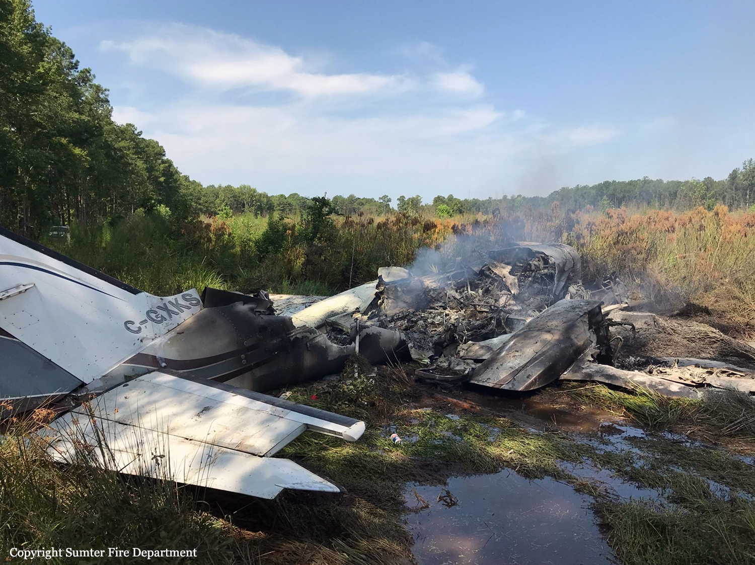
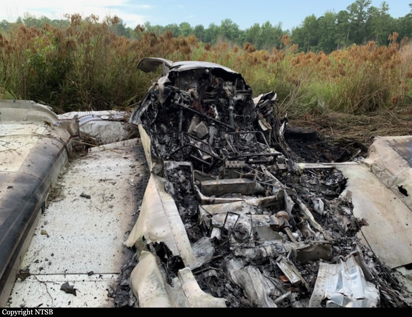
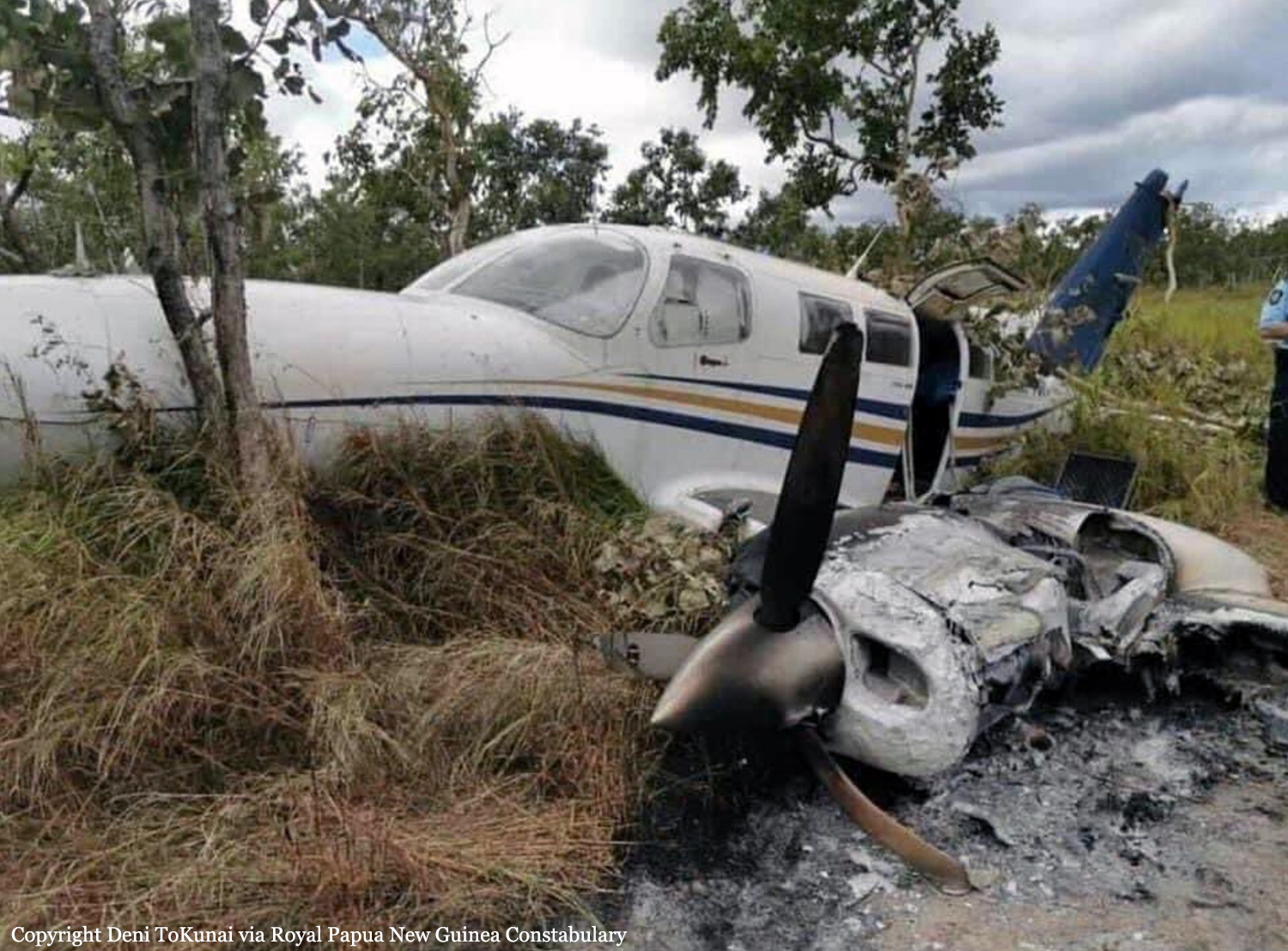
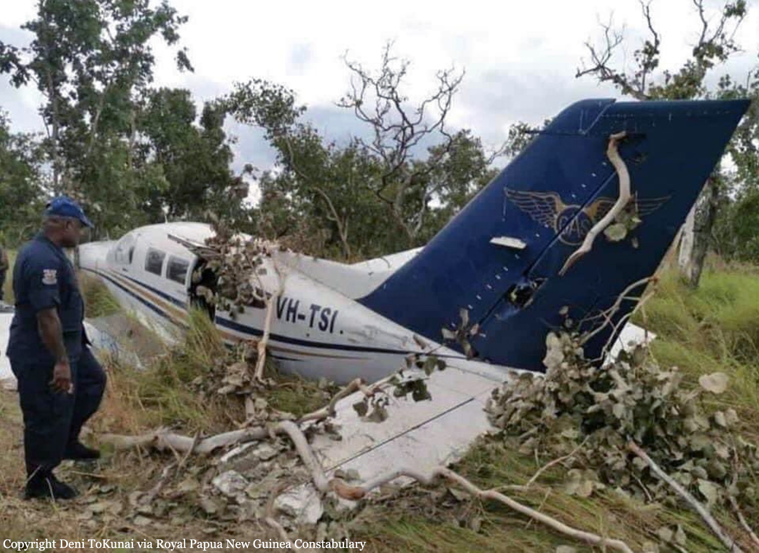
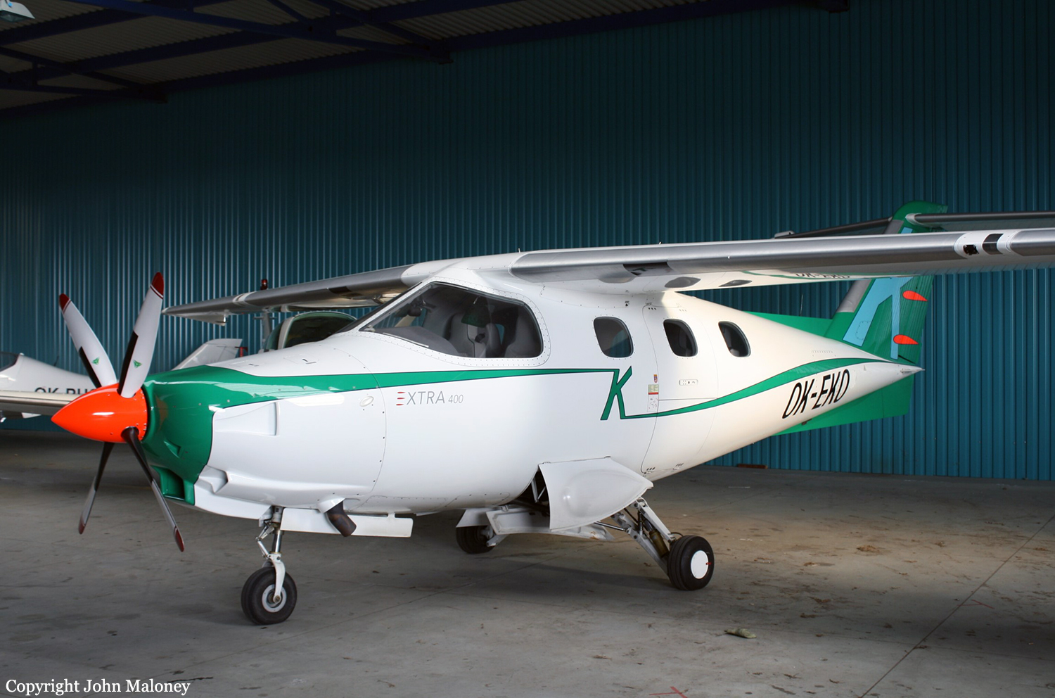
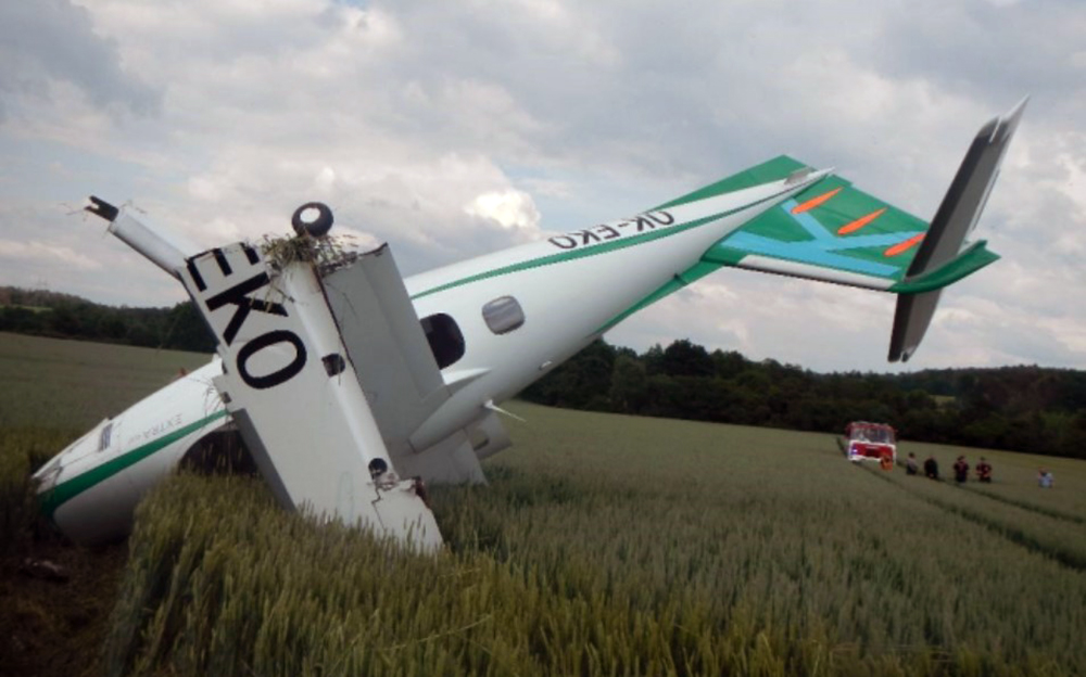
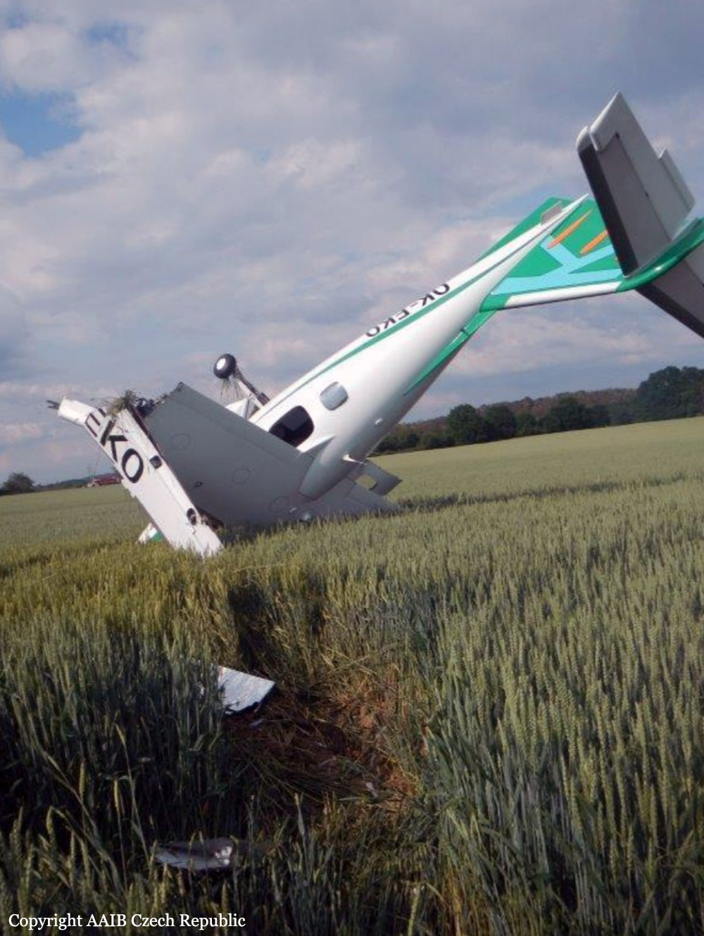
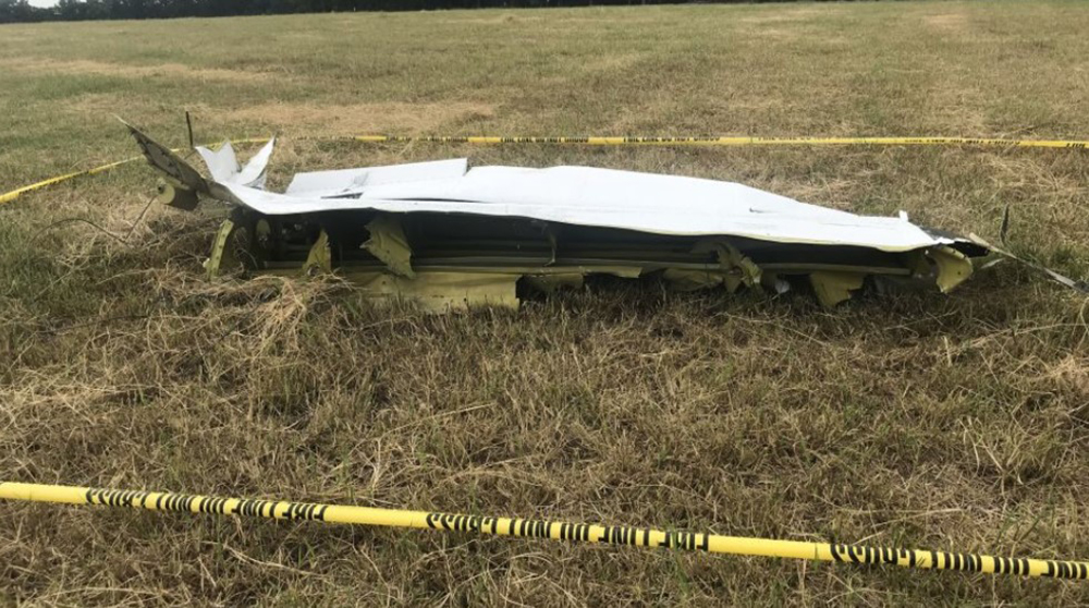
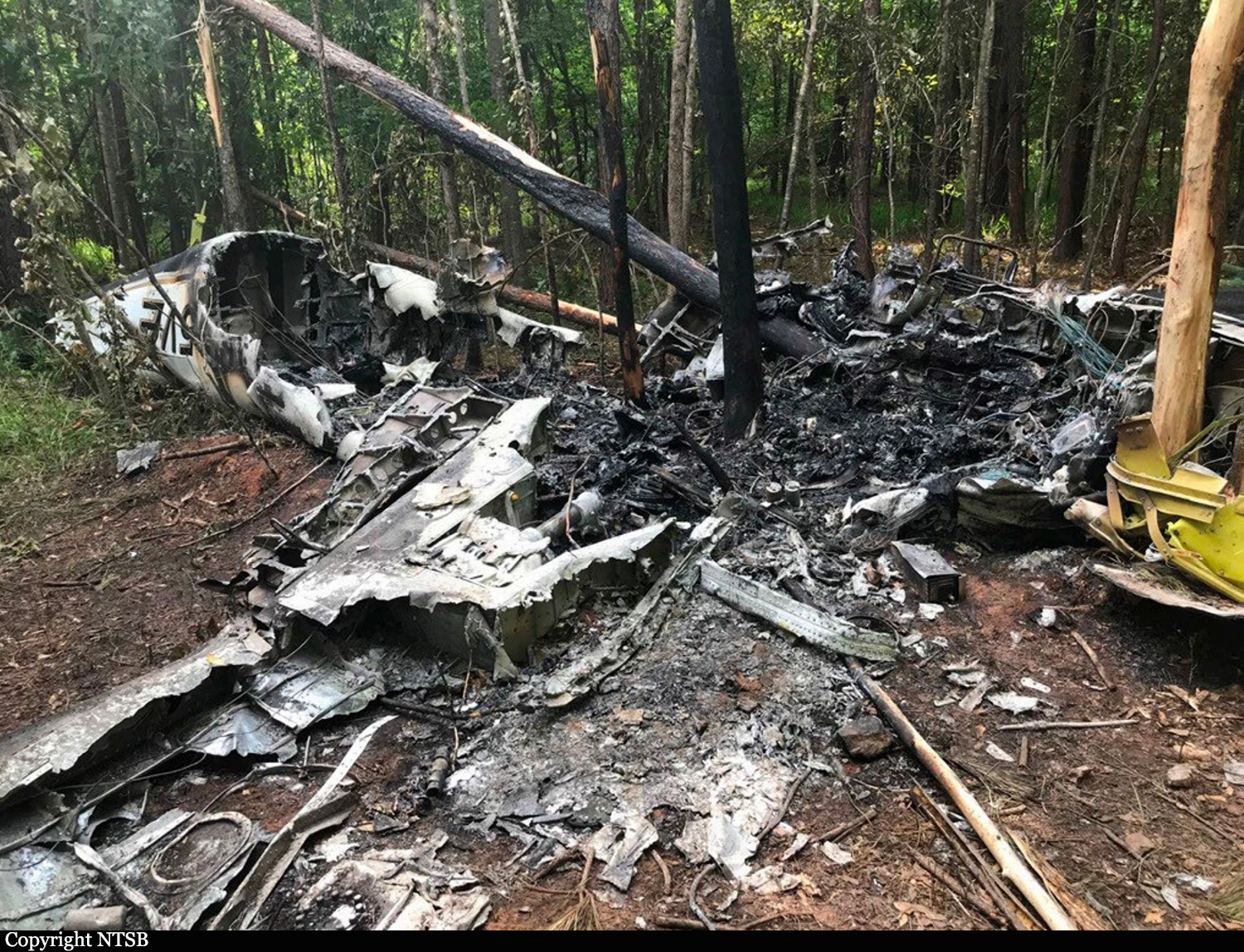
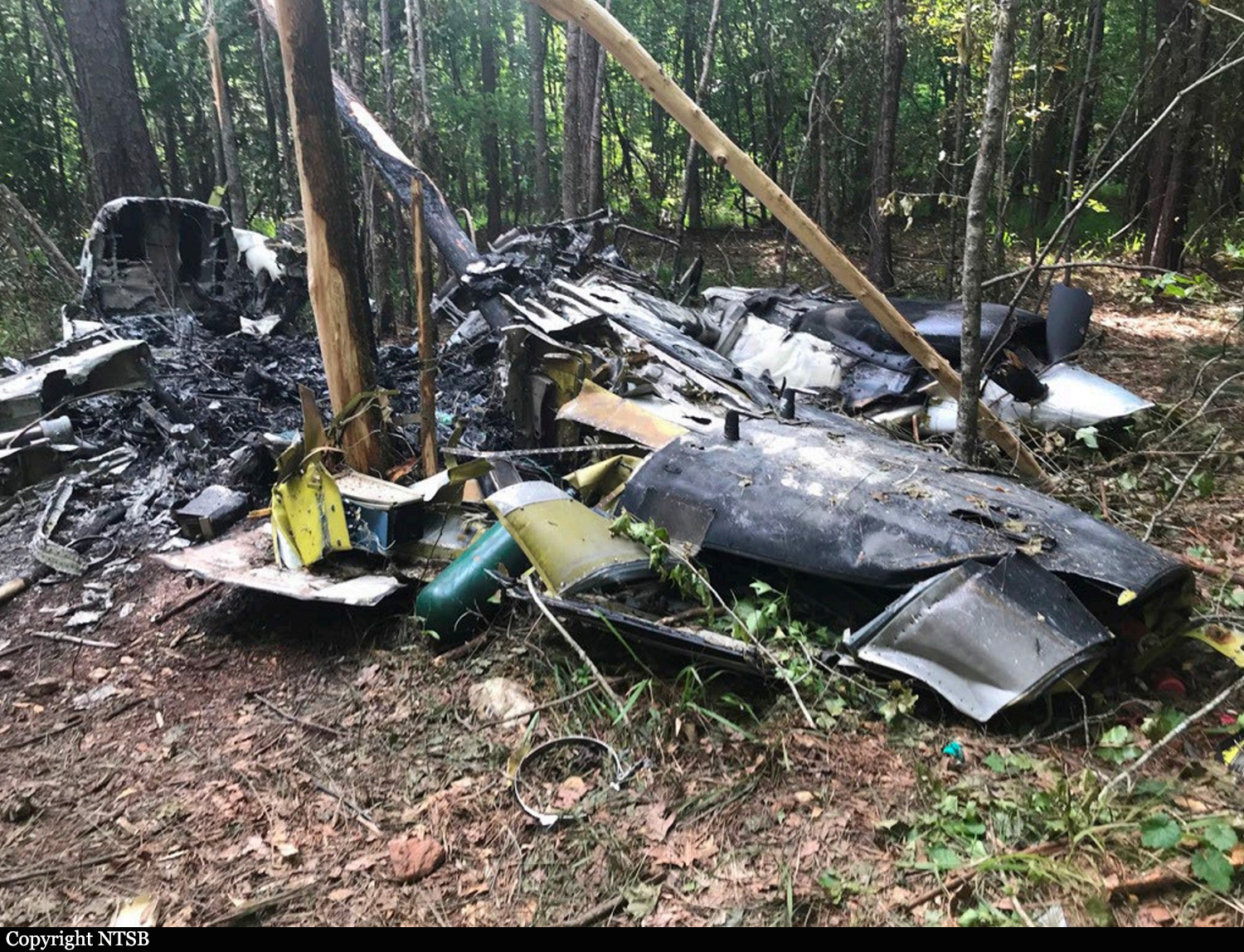
Crash of a BAE 125-700A near La Libertad: 2 killed

Date & Time: Apr 19, 2020
Type of aircraft:
Operator:
Registration:
N700NW
Flight Phase:
Flight Type:
Survivors:
No
MSN:
257063
YOM:
1979
Country:
Crew on board:
2
Crew fatalities:
Pax on board:
0
Pax fatalities:
Other fatalities:
Total fatalities:
2
Circumstances:
The aircraft crashed in unknown circumstances in a wooded area located near La Libertad and was totally destroyed by impact forces and a post crash fire. Both pilots were killed. Guatemalan Authorities reported the aircraft was engaged in a contraband mission and a load of 762 kilos of cocaine was found.

Crash of a BAe 125-F400B in Caballo Blanco

Date & Time: Mar 22, 2020
Type of aircraft:
Operator:
Registration:
XB-PNK
Flight Type:
Survivors:
Yes
MSN:
25227
YOM:
1970
Country:
Crew on board:
0
Crew fatalities:
Pax on board:
0
Pax fatalities:
Other fatalities:
Total fatalities:
0
Circumstances:
Probably engaged in an illegal contraband flight, the crew attempted to land on a road when the aircraft crashed against a vehicle parked in a sugarcane field and awaiting for the it, bursting into flames. No one was found on site. The airplane was damaged beyond repair. The registration XN-PNK is false, the older one was XB-OUF.

Crash of a Cessna 208B Super Cargomaster in La Crosse: 1 killed

Date & Time: Mar 17, 2020 at 0919 LT
Type of aircraft:
Operator:
Registration:
N274PM
Flight Phase:
Flight Type:
Survivors:
No
Schedule:
Wichita - Hays
MSN:
208B-0705
YOM:
1998
Flight number:
PMS1670
Crew on board:
1
Crew fatalities:
Pax on board:
0
Pax fatalities:
Other fatalities:
Total fatalities:
1
Captain / Total flying hours:
9900
Circumstances:
The pilot was conducting a Part 135 on-demand cargo flight in instrument meteorological conditions. After executing a second missed approach, he informed air traffic control (ATC) of his intentions to divert to an airport located about 36 miles to the southeast. About 7 minutes after executing the second missed approach, the pilot began making unintelligible radio communications that ATC characterized as very garbled and difficult to understand, “almost hypoxic.” ATC then instructed the pilot to utilize oxygen. About 19 minutes after the second missed approach, ATC informed the pilot that the airplane had descended 1,600 ft, not following assigned course vectors or instructions and asked if everything was alright, to which no response was received. After attempting to relay communications through other airplanes in the area, an unintelligible response was received from the accident airplane. ATC then made numerous transmissions to the accident pilot urging him to utilize oxygen and open a window. No further communications were received from the accident airplane. A witness reported that he saw the airplane descend out of a low overcast cloud layer at a high rate of descent. The airplane then abruptly transitioned into a steep climb before re-entering the clouds. A few seconds later, he heard the airplane impact terrain and responded to the accident site. The sudden change in communications from the pilot indicates a possible impairment. When combined with the ATC data, the witness account, and the lack of any mechanical irregularities or malfunctions with the airplane, it is likely the pilot experienced difficulty controlling the airplane due to impairment. While the pilot was at an increased risk for an acute cardiovascular event, the extremely limited available medical evidence leaves no way to quantify that risk and no evidence regarding whether such an event occurred. As a result, whether the pilot was incapacitated by an acute medical event cannot be determined from the available medical information.
Probable cause:
An infight loss of control as a result of pilot impairment, the cause of which could not be determined.
Final Report:

Crash of a Piper PA-46-310P Malibu in Bishop: 3 killed

Date & Time: Mar 3, 2020 at 1634 LT
Registration:
N43368
Flight Phase:
Flight Type:
Survivors:
No
Schedule:
Columbia – Tuscaloosa
MSN:
46-8408028
YOM:
1984
Location:
Crew on board:
1
Crew fatalities:
Pax on board:
2
Pax fatalities:
Other fatalities:
Total fatalities:
3
Captain / Total flying hours:
1178
Circumstances:
The pilot departed on an instrument flight rules cross-country flight with three passengers. While enroute at a cruise altitude about 6,000 ft mean sea level (msl), the pilot discussed routing and weather avoidance with the controller. The controller advised the pilot there was a gap in the line of weather showing light precipitation, and that the pilot could pass through it and then proceed on course. The controller assigned the pilot a heading, which the pilot initially acknowledged, but shortly thereafter, he advised the controller that the airplane was pointed directly at a convective cell. The controller explained that the heading would keep the pilot out of the heavy precipitation and that he would then turn the airplane through an area of light precipitation. The pilot responded, saying that the area seemed to be closing in fast, the controller acknowledged and advised the pilot if he did not want to accept that routing, he could be rerouted. The pilot elected to turn toward a gap that he saw and felt he could fly straight through it. The controller acknowledged and advised the pilot that course would take him through moderate precipitation starting in about one mile extending for about four miles; the pilot acknowledged. Radar information indicated that the airplane entered an area of heavy to very heavy precipitation, likely a rain shower updraft, while in instrument meteorological conditions, then entered a right, descending spiral and broke up in flight. Examination of the wreckage revealed no evidence of a preaccident malfunction or failure that would have prevented normal operation. The airplane was equipped with the capability to display weather radar "mosaic" imagery created from Next Generation Radar (NEXRAD) data and it is likely that the pilot was using this information to navigate around precipitation when the airplane encountered a rain shower updraft with likely severe turbulence. Due to latencies inherent in processes used to detect and deliver the NEXRAD data from the ground site, as well as the frequency of the mosaic-creation process used by the service provider, NEXRAD data can age significantly by the time the mosaic image is created. The pilot elected to navigate the hazardous weather along his route of flight based on the data displayed to him instead of the routing suggested by the controller, which resulted in the penetration of a rain shower updraft, a loss of airplane control, and a subsequent inflight breakup.
Probable cause:
The pilot’s encounter with a rain shower updraft and severe turbulence, which resulted in a loss of airplane control and an inflight breakup. Contributing to the accident was the pilot’s reliance on outdated weather information on his in-cockpit weather display.
Final Report:

Crash of a Beechcraft B200 Super King near Coleman: 3 killed

Date & Time: Feb 20, 2020 at 0600 LT
Operator:
Registration:
N860J
Flight Phase:
Flight Type:
Survivors:
No
Schedule:
Abilene – Harlingen
MSN:
BB-1067
YOM:
1982
Location:
Crew on board:
1
Crew fatalities:
Pax on board:
2
Pax fatalities:
Other fatalities:
Total fatalities:
3
Captain / Total flying hours:
5300
Circumstances:
The pilot and two passengers departed on an instrument flight rules cross-country flight in night instrument meteorological conditions (IMC). The pilot was instructed by air traffic control to climb to 12,000 ft, and then cleared to climb to FL230. The pilot reported to the controller that the airplane encountered freezing drizzle and light rime icing during the climb from 6,500 ft to 8,000 ft mean sea level (msl). As the airplane climbed through 11,600 ft msl, the pilot reported that they had an issue with faulty deicing equipment and needed to return to the airport. The controller instructed the pilot to descend and cleared the airplane back to the airport. When asked by the controller if there was an emergency, the pilot stated that they “blew a breaker,” and were unable to reset it. As the controller descended the airplane toward the airport, the pilot reported that they were having issues with faulty instruments. At this time, the airplane was at an altitude of about 4,700 ft. The controller instructed the pilot to maintain 5,000 ft, and the pilot responded that he was “pulling up.” There was no further communication with the pilot. Review of the airplane’s radar track showed the airplane’s departure from the airport and the subsequent turn and southeast track toward its destination. The track appeared as a straight line before a descending, right turn was observed. The turn radius decreased before the flight track ended. The airplane impacted terrain in a right-wing-low attitude. The wreckage was scattered and highly fragmented along a path that continued for about 570 ft. Examination of the wreckage noted various pieces of the flight control surfaces and cables in the wreckage path. Control continuity could not be established due the fragmentation of the wreckage; however, no preimpact anomalies were found. Examination of the left and right engines found rotational signatures and did not identify any pre-impact anomalies. A review of maintenance records noted two discrepancies with the propeller deice and surface deice circuit breakers, which were addressed by maintenance personnel. Impact damage and fragmentation prevented determination of which circuit breaker(s) the pilot was having issues with or an examination of any deicing systems on the airplane. The radio transmissions and transponder returns reflected in the radar data indicate that the airplane’s electrical system was operational before the accident. It is likely that the pilot’s communications with the controller and attempted troubleshooting of the circuit breakers introduced distractions from his primary task of monitoring the flight instruments while in IMC. Such interruptions would make him vulnerable to misleading vestibular cues that could adversely affect his ability to effectively interpret the instruments and maintain control of the airplane. The pilot’s report of “faulty instruments” during a decreasing radius turn and his initial distraction with the circuit breakers and radio communications is consistent with the effects of spatial disorientation.
Probable cause:
The pilot’s loss of airplane control due to spatial disorientation. Contributing to the accident was the pilot’s distraction with a “popped” circuit breaker and communications with air traffic control.
Final Report:

Crash of a Cessna 501 Citation I/SP near Fairmount: 4 killed

Date & Time: Feb 8, 2020 at 1013 LT
Type of aircraft:
Operator:
Registration:
N501RG
Flight Phase:
Flight Type:
Survivors:
No
Schedule:
Peachtree City - Nashville
MSN:
501-0260
YOM:
1982
Crew on board:
2
Crew fatalities:
Pax on board:
2
Pax fatalities:
Other fatalities:
Total fatalities:
4
Captain / Total flying hours:
805
Copilot / Total flying hours:
5924
Copilot / Total hours on type:
55
Aircraft flight hours:
8078
Circumstances:
While on an instructional flight in icing and instrument meteorological conditions (IMC), the pilots indicated that they were having instrumentation difficulties to air traffic control. They initially reported a problem with the autopilot, then a navigational issue, which they later indicated were resolved, and finally they reported it was a problem with the left side attitude indicator. After air traffic control cleared them to their destination, the airplane entered a descending left turn, which continued into a 360° descending turn. An inflight breakup resulted, with the wreckage being scattered over 7,000 ft of wooded terrain. Examination of the engines revealed there were no anomalies that would have precluded normal operation prior to the accident. Control cable continuity was established from the flight controls in the cockpit to all flight control surfaces through multiple overload failures. The pitot-static system was examined, and no blockages were noted. Since there was rotational scoring noted on the vertical gyro and the directional gyro, it’s likely they were operating at the time of the accident. Furthermore, the left side attitude indicator examination revealed that there were no anomalies with the instrument. Examination of the deice valves for the deicing boots revealed that the left wing deice valve did not operate. Corrosion was visible in all three valves and it could not be determined if the corrosion was a result of postimpact environmental exposure. Furthermore, since the cockpit switch positions were compromised in the accident, it could not be determined if the pilots were operating the deicing system at the time of the accident. However, most of the pilot reports (PIREPs) in the area indicated light icing and the airplane performed a 6,000 ft per minute climb just before the loss of control. Given this information, it is unlikely the icing conditions made the airplane uncontrollable. A review of the pilots’ flight experience revealed that the pilot in the left seat did not hold a type rating for the accident airplane model but was scheduled to attend flight training to obtain such a type rating. The pilot in the right seat, who also held a flight instructor certificate, did hold a type rating for the airplane. Given that the remarks section of the filed flight plan described the flight as a “training flight” and the left-seat pilot’s plan to obtain a type rating for the accident airplane model, it is likely the pilot in the left seat was the flying pilot for the majority of the flight. Although the right-seat pilot's autopsy noted coronary artery disease, the condition was poorly described. The circumstances of the accident are not consistent with sudden physical impairment or incapacitation; therefore, it is unlikely it contributed to the event. Toxicology testing identified diphenhydramine, which can cause significant sedation, in the right-seat pilot’s blood. However, the level present at the time of the accident was too low to quantify. Therefore, it is unlikely effects from diphenhydramine contributed to the accident. Prior to entering the descending right turn, air traffic control noted that the airplane was not following assigned headings and altitudes and the pilots’ reported having autopilot problems. Subsequently, the pilots’ reported they were using the right attitude indicator as they had difficulties with the left-side indicator. Information was insufficient to evaluate whether the reported difficulties were the result of a malfunction of the autopilot or the pilots’ management of the autopilot system. However, the reported difficulties likely increased the pilots’ workload, may have diverted their attention while operating in IMC and icing conditions, resulting in task saturation, and may have increased their susceptibility to spatial disorientation. It is also possible that the onset of spatial disorientation was the beginning of the pilots’ difficulties maintaining the airplane’s flight track and what they perceived to be an instrumentation problem. Regardless, since the left seat pilot was not rated to fly the airplane, the right seat pilot’s workload would have increased by having to diagnose the issue, assess the situation, and maintain positive airplane control. The airplane’s track data are consistent with the known effects of spatial disorientation, leading to an inflight loss of control and subsequent inflight breakup.
Probable cause:
The pilots’ loss of control in flight in freezing instrument meteorological conditions due to spatial disorientation and the cumulative effects of task saturation.
Final Report:

Crash of a Bombardier Global Express E-11A near Sharana AFB: 2 killed

Date & Time: Jan 27, 2020 at 1309 LT
Operator:
Registration:
11-9358
Flight Phase:
Flight Type:
Survivors:
No
Schedule:
Kandahar - Kandahar
MSN:
9358
YOM:
2009
Country:
Region:
Crew on board:
2
Crew fatalities:
Pax on board:
0
Pax fatalities:
Other fatalities:
Total fatalities:
2
Captain / Total flying hours:
4736
Captain / Total hours on type:
1053.00
Copilot / Total flying hours:
1343
Copilot / Total hours on type:
27
Circumstances:
On 27 January 2020, at approximately 1309 hours local time (L), an E-11A, tail number (T/N) 11-9358, was destroyed after touching down in a field in Ghanzi Province, Afghanistan (AFG) following a catastrophic left engine failure. The mishap crew (MC) were deployed and assigned to the 430th Expeditionary Electronic Combat Squadron (EECS), Kandahar Airfield (KAF), AFG. The MC consisted of mishap pilot 1 (MP1) and mishap pilot 2 (MP2). The mission was both a Mission Qualification Training – 3 (MQT-3) sortie for MP2 and a combat sortie for the MC, flown in support of Operation FREEDOM’S SENTINEL. MP1 and MP2 were fatally injured as a result of the accident, and the Mishap Aircraft (MA) was destroyed. At 1105L, the MA departed KAF. The mission proceeded uneventfully until the left engine catastrophically failed one hour and 45 minutes into the flight (1250:52L). Specifically, a fan blade broke free causing the left engine to shutdown. The MC improperly assessed that the operable right engine had failed and initiated shutdown of the right engine leading to a dual engine out emergency. Subsequently, the MC attempted to fly the MA back to KAF, approximately 230 nautical miles (NM) away. Unfortunately, the MC were unable to get either engine airstarted to provide any usable thrust. This resulted in the MA unable to glide the distance remaining to KAF. With few options remaining, the MC maneuvered the MA towards Forward Operating Base (FOB) Sharana, but did not have the altitude and airspeed to glide the remaining distance. The MC unsuccessfully attempted landing in a field approximately 21 NM short of FOB Sharana.
Probable cause:
The Accident Investigation Board (AIB) President found by a preponderance of the evidence that the cause of the mishap was the MC’s error in analyzing which engine had catastrophically failed (left engine). This error resulted in the MC’s decision to shutdown the operable right engine creating a dual engine out emergency. The AIB President also found by a preponderance of the evidence that the MC’s failure to airstart the right engine and their decision to recover the MA to KAF substantially contributed to the mishap.
Final Report:

Crash of a Lockheed EC-130Q Hercules near Peak View: 3 killed

Date & Time: Jan 23, 2020 at 1315 LT
Type of aircraft:
Operator:
Registration:
N134CG
Flight Phase:
Flight Type:
Survivors:
No
Schedule:
Richmond - Richmond
MSN:
4904
YOM:
1981
Flight number:
Bomber 134
Country:
Region:
Crew on board:
3
Crew fatalities:
Pax on board:
0
Pax fatalities:
Other fatalities:
Total fatalities:
3
Captain / Total flying hours:
4010
Captain / Total hours on type:
3010.00
Copilot / Total flying hours:
1744
Copilot / Total hours on type:
1364
Aircraft flight hours:
11888
Circumstances:
At about 1205, while B137 was overhead the Adaminaby fire-ground, and about the same time the SAD logged the birddog rejection, B134 departed Richmond as initial attack. On board were the PIC, the copilot and flight engineer. In response to the draft report, the RFS provided excerpts from the state operations controller (SOC) log. An entry was written in the log by the SOC following the accident. The SOC noted having been advised that the birddog had indicated it was ‘not safe to fly’ and that B137 was not returning to the area until the conditions had eased. However, B134 would continue with the PIC to make the ‘decision of safety of bombing operations’. The RFS advised the ATSB that the SOC had the authority to cancel B134’s tasking, but instead allowed it to proceed, with the intention of gathering additional intelligence to assist in determining whether further aerial operations would proceed. The RFS further reported that this indicated an ongoing intelligence gathering and assessment process by the SOC. At about 1235, while returning to Richmond, the PIC of B137 heard the PIC of B134 on the Canberra approach frequency, and contacted them via their designated operating frequency. At that time, B134 was about 112 km north-east of Adaminaby, en route to the fire-ground. In this conversation, the PIC of B137 informed them of the actual conditions and that they would not be returning to Adaminaby. The PIC of B137 reported that they could not recall the specific details of the call, but that the conversation included that they were ‘getting crazy winds’ and ‘you can go take a look’ ’but I am not going back’. It was also noted that the PIC of B134 had asked several questions. It was reported by the majority of the operator’s pilots that, despite receiving information from another pilot, they would have also continued with the tasking under these circumstances, to assess the conditions themselves. At about 1242, the crew of B134 contacted air traffic control to advise them of the coordinates they would be working at, provide an ‘ops normal’ call time, and confirm there was no reported instrument flight rules aircraft in the area. About 5 minutes later, the Richmond ABM also attempted to contact the crew of B134 to confirm ‘ops normal’, firstly by radio, and then by text to the PIC’s mobile phone, but did not receive a response. The automatic dependent surveillance broadcast (ADS-B) data showed that, after arriving at the Adaminaby fire-ground at about 1251, the crew of B134 completed several circuits at about 2,000 ft AGL. At about 1255, the crew advised the Cooma ARO that it was too smoky and windy to complete a retardant drop at that location. The Cooma ARO then provided the crew with the approximate coordinates of the Good Good fire, about 58 km to the east of Adaminaby. The ARO further indicated that they had no specific requirements, but they could look for targets of opportunity, with the objective of conducting structure and property protection near Peak View. At about 1259, the crew of B134 contacted air traffic control to advise that they had been re-tasked to the Good Good fire-ground, and provided updated coordinates. At about the same time, the RFS ground firefighters at the Good Good fire-ground, near Feeney’s Road in Peak View, contacted the Cooma FCC and requested additional assets for property protection. They were advised that a LAT would be passing overhead in about 10 minutes. The firefighters acknowledged the intention of a LAT retardant drop and advised the Cooma FCC they would wait in open country on Feeney’s Road, clear of any properties targeted for protection. At about 1307, B134 arrived overhead the drop area. The drop area was located to the east of a ridgeline, with the fire on the western side of the ridgeline. The aircraft’s recorded track data (SkyTrac) showed that the crew conducted 3 left circuits, at about 1,500 ft, 500 ft and 1,000 ft AGL respectively, prior to commencing the drop circuit. At about 1312, after conducting about 2 circuits, they advised the Cooma ARO of their intention to complete multiple drops on the eastern side of the Good Good fire, and that they would advise the coordinates after the first delivery. At 1315:15, a partial retardant drop was conducted on a heading of about 190°, at about 190 ft AGL (3,600 ft above mean sea level). During the drop, about 1,200 US gallons (4,500 L) of fire retardant was released over a period of about 2 seconds. A ground speed of 144 kt was recorded at the time of the drop. A witness video taken by ground fire-fighters captured the drop and showed the aircraft immediately after the drop in an initial left turn with a positive rate of climb, before it became obscured by smoke. While being intermittently obscured by smoke, the aircraft climbed to about 330 ft AGL (3,770 ft above mean sea level). At about this time, ATSB analysis of the video showed that the aircraft was rolling from about 18° left angle of bank to about a 6° right angle of bank. Following this, the aircraft descended and about 17 seconds after the completion of the partial retardant drop, it was seen at a very low height above the ground, in a slight left bank. Video analysis and accident site examination showed there was no further (emergency) drop of retardant. Throughout this period, the recorded groundspeed increased slightly to a maximum of 151 kt. Shortly after, there was a significant left roll just prior to ground impact. At about 1315:37, the aircraft collided with terrain and a post-impact fuel-fed fire ensued. The 3 crew were fatally injured and the aircraft was destroyed. A review of the Airservices Australia audio recording of the applicable air traffic control frequency found no distress calls were received by controllers prior to the impact.
Probable cause:
The following contributing factors were identified:
- Hazardous weather conditions were forecast and present at the drop site near Peak View, which included strong gusting winds and mountain wave activity, producing turbulence. These
conditions were likely exacerbated by the fire and local terrain.
- The Rural Fire Service continued the B134 tasking to Adaminaby when they learned that no other aircraft would continue to operate due to the environmental conditions. In addition, they relied on the pilot in command to assess the appropriateness of the tasking to Adaminaby without providing them all the available information to make an informed decision on flight safety.
- The pilot in command of B134 accepted the Adaminaby fire-ground tasking, which was in an area of forecast mountain wave activity and severe turbulence. After assessing the conditions as unsuitable, the crew accepted an alternate tasking to continue to the Good Good (Peak View) fire-ground, which was subject to the same weather conditions. The acceptance of these taskings were consistent with company practices.
- Following the partial retardant drop and left turn, the aircraft was very likely subjected to hazardous environmental conditions including low-level windshear and an increased tailwind component, which degraded the aircraft’s climb performance.
- While at a low height and airspeed, it was likely the aircraft aerodynamically stalled, leading to a collision with terrain.
- Coulson Aviation's safety risk management processes did not adequately manage the risks associated with large air tanker operations. There were no operational risk assessments conducted or a risk register maintained. Further, as safety incident reports submitted were mainly related to maintenance issues, operational risks were less likely to be considered or monitored. Overall, this limited their ability to identify and implement mitigations to manage the risks associated with their aerial firefighting operations. (Safety issue)
- Coulson Aviation did not provide a pre-flight risk assessment for their firefighting large air tanker crews. This would provide predefined criteria to ensure consistent and objective decision-making with accepting or rejecting tasks, including factors relating to crew, environment, aircraft and external pressures. (Safety issue)
- The New South Wales Rural Fire Service had limited large air tanker policies and procedures for aerial supervision requirements and no procedures for deployment without aerial supervision.(Safety issue)
- The New South Wales Rural Fire Service did not have a policy or procedures in place to manage task rejections, nor to communicate this information internally or to other pilots working in the same area of operation. (Safety issue)

Other factors that increased risk:
- The B134 crew were very likely not aware that the 'birddog' pilot had declined the tasking to Adaminaby fire-ground, and the smaller fire-control aircraft had ceased operations in the area, due to the hazardous environmental conditions
- In the limited time available, the remainder of the fire-retardant load was not jettisoned prior to the aircraft stalling.
- Coulson Aviation did not include a windshear recovery procedure or scenario in their C-130 Airplane Flight Manual and annual simulator training respectively, to ensure that crews consistently and correctly responded to a windshear encounter with minimal delay. (Safety issue)
- Coulson Aviation fleet of C-130 aircraft were not fitted with a windshear detection system, which increased the risk of a windshear encounter and/or delayed response to a windshear encounter during low level operations. (Safety issue)
- The New South Wales Rural Fire Service procedures allowed operators to determine when pilots were initial attack capable. However, they intended for the pilot in command to be certified by the United States Department of Agriculture Forest Service certification process. (Safety issue)

Other findings:
- The aircraft's cockpit voice recorder did not record the accident flight, which resulted in a valuable source of safety information not being available. This limited the extent to which potential factors contributing to the accident could be identified.
Final Report:

Crash of a De Havilland DHC-2 Beaver in Sadiqabad: 2 killed

Date & Time: Jan 12, 2020
Type of aircraft:
Registration:
AP-AMB
Flight Phase:
Survivors:
No
Schedule:
Rahim Yar Khan - Rahim Yar Khan
MSN:
1415
YOM:
1960
Country:
Region:
Crew on board:
2
Crew fatalities:
Pax on board:
0
Pax fatalities:
Other fatalities:
Total fatalities:
2
Circumstances:
The airplane departed Rahim Yar Khan-Sheikh Zayed Airport and was spraying pesticide in the area to tackle another wave of locust attacks, which began in December 2019, on the request of the district administration. In unknown circumstances, the single engine airplane went out of control and crashed in a sandy area located in Sadiqabad, killing both crew members, a pilot and a flight engineer. They were completing a mission on behalf of the Department of Agriculture of Pakistan. Initial investigations suggest the plane crashed due to a technical fault.

Crash of a Boeing 737-8KV in Sabashahr: 176 killed

Date & Time: Jan 8, 2020 at 0618 LT
Type of aircraft:
Operator:
Registration:
UR-PSR
Flight Phase:
Survivors:
No
Schedule:
Tehran - Kiev
MSN:
38124
YOM:
2016
Flight number:
PS752
Country:
Region:
Crew on board:
9
Crew fatalities:
Pax on board:
167
Pax fatalities:
Other fatalities:
Total fatalities:
176
Captain / Total flying hours:
11590
Captain / Total hours on type:
8428.00
Copilot / Total flying hours:
7633
Copilot / Total hours on type:
3642
Circumstances:
On Wednesday, January 08, 2020, at 00:53, the inbound flight No. 751 of Ukraine International, Boeing 737-800, UR-PSR, en route to Tehran Imam Khomeini INTL. Airport from Kyiv Boryspyl INTL. Airport was cleared for landing, and after four minutes landed on the IKA runway. After disembarking 58 passengers and refueling, the flight crew went on to check into the hotel located at IKA. From 01:16 to 01:38, the aircraft was refueled with 9510 kg (11800 liters) of fuel. Once the total weight of the cargo received from passengers (310 packages weighing 6794 kg) was determined, in order to comply with the maximum takeoff weight allowed for aircraft, 82 packages in 2094 kg in weight, were separated by Airport Service Company, that is, they were not loaded. Initially, 78 packages of the passenger's luggage were not loaded first, then due to the large volume of passengers' hand luggage, the flight attendants passed some of them on to the Airport Service Company personnel to be placed in the aircraft cargo. After that, 4 packages belonging to the passengers were removed from the aft cargo door, where the hand luggage was placed. At 04:35, the flight crew embarked on the aircraft. After checking the aircraft and cabin, boarding was announced at 04:45, and passengers started to board the plane. Based on the available documents, 167 passengers proceeded to the Airport Services Co. counter at the airport terminal, all of whom went on board. Only one of the passengers who received the boarding pass online the night before the flight, due to the delay in arriving in Tehran from another city did not go to the airport in person, and therefore had been removed from the list of passengers provided by the UIA. At 05:13, the pilot made his first radio contact with the IKA's control tower ground unit and requested the initial clearance for flying, which was issued by the controller subsequently. At 05:48, all the aircraft documents required to start the flight operations were filled out, and all the doors were then closed at 05:49. The flight was initially scheduled for 05:15, and based on the flight coordinator's report form, the reason given for its delay was the aircraft being overweight and the decision not to load the passengers' lugga for reducing the aircraft weight. At 05:51 the pilot notified his position at the airport parking, declared his readiness to exit the parking and start up the aircraft. The IKA tower asked him to wait for receiving the clearance since they wanted to make the coordination required with other relevant units. At 05:52, the IKA tower made the necessary coordination with the Mehrabad approach unit, who contacted Tehran ACC asking for clearance. Accordingly, the controller in ACC made coordination on Ukrainian flight clearance with the CMOCC. The clearance was issued by the CMOCC. At 05:54, the Mehrabad approach unit, received the FL260 clearance for the flight AUI752 from ACC, and forwarded it to IKA via the telecommunication system. Flight no. 752 was detached from the A1 Jet Bridge and at about 05:55 started to leave its parking position, NO 116 on the right, by a pushback truck. Following that, at 05:55 the ground controller cleared the AUI752 flight for startup and exiting the parking, which was read back by the pilot. At 06:12, the aircraft took off from the Runway 29 Right of IKA and was delivered to the Mehrabad approach unit. The pilot contacted the approach unit, and announced the IKA 1A radar procedure as SID procedure. Next, the Mehrabad approach identified and cleared the flight to climb to FL260. The controller instructed the pilot to turn to the right after 6,000 feet, and continue straight to PAROT. After it was read back by the pilot, the controller again instructed the pilot to continue to PAROT point once passing the 6000-foot altitude, which was read back by the pilot. From 06:17 onwards, upon the disappearance of the PS752 information from the radarscope, the controller called the captain repeatedly, but received no response. According to the data extracted from the surveillance systems and FDR, the aircraft climbed to an altitude of 8,100 feet; thereafter, the label including the call sign and altitude of aircraft disappeared from the radarscope, yet no radio contact indicating unusual conditions was received from the pilot. FDR recording terminated at 06:14:56. This time corresponds to the termination of Secondary Surveillance Radar (SSR) and ADS-B information. After the mentioned time, the aircraft was still being detected by the Primary Surveillance Radar (PSR), according to which the aircraft veered right and after approximately three minutes of flying, it disappeared from the PSR at 06:18 too. The aircraft was conducting the flight under the Instrument Flight Rules (IFR) and the accident occurred around half an hour before the sunset.
Probable cause:
Cause of the Accident:
- The air defense's launching two surface-to-air missiles at the flight PS752, UR-PSR aircraft the detonation of the first missile warhead in proximity of the aircraft caused damage to the aircraft systems and the intensification of damage led the aircraft to crash into the ground and explode instantly.

Other Contributing Factors:
- The mitigating measures and defense layers in risk management proved to be ineffective due to the occurrence of an unanticipated error in threat identifications, and ultimately failed to protect the flight safety against the threats caused by the alertness of defense forces.
Final Report: