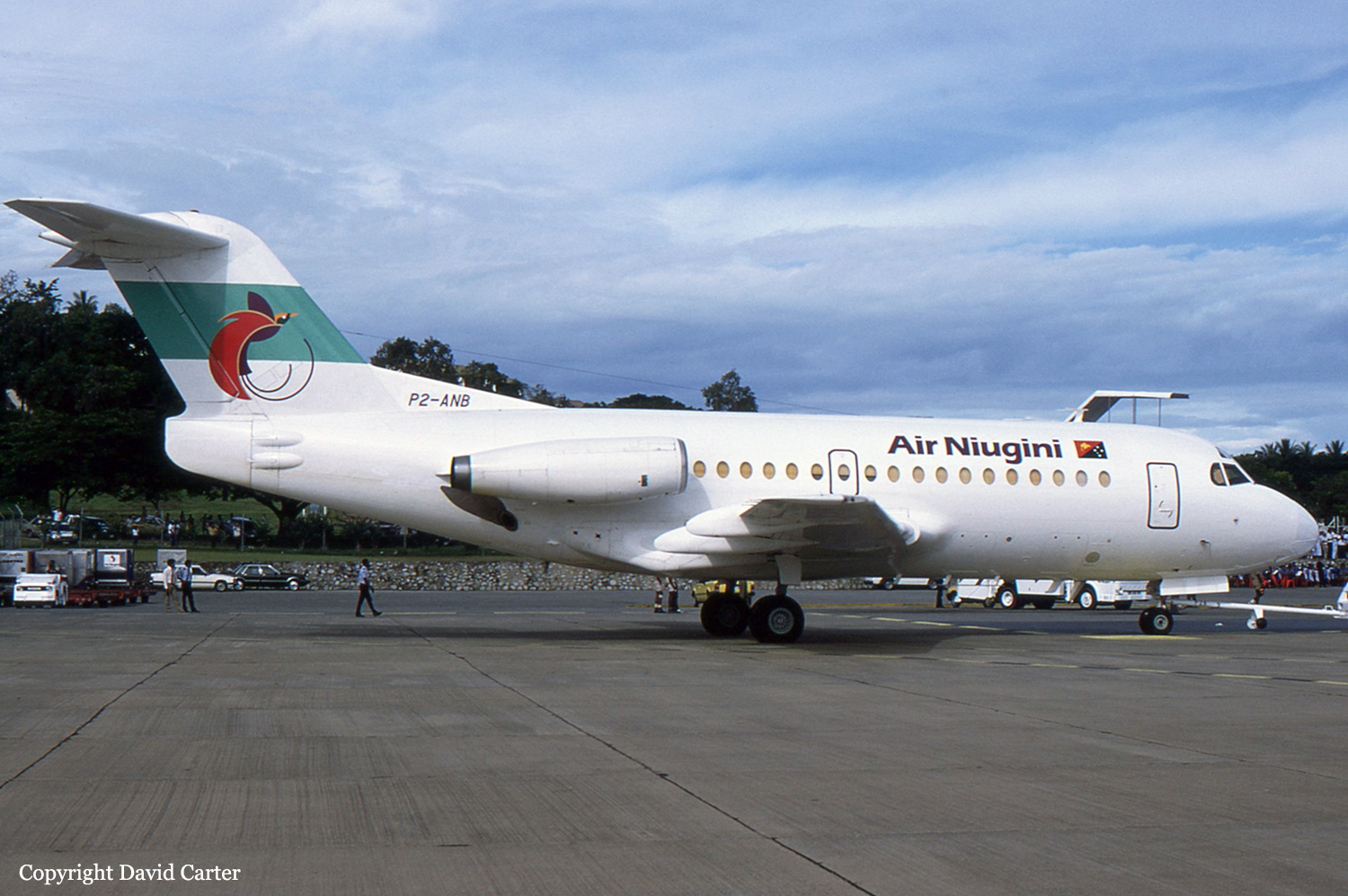
Crash of a Fokker F28 Fellowship 1000 in Madang

Date & Time: May 31, 1995 at 2210 LT
Type of aircraft:
Operator:
Registration:
P2-ANB
Survivors:
Yes
Schedule:
Port Moresby – Lae – Madang
MSN:
11049
YOM:
1972
Flight number:
PX128
Location:
Region:
Crew on board:
4
Crew fatalities:
Pax on board:
35
Pax fatalities:
Other fatalities:
Total fatalities:
0
Circumstances:
Following an uneventful flight from Lae, the crew started the approach to Madang Airport runway 25. The visibility was limited by night and poor weather conditions. In heavy rain falls, the captain realized that all conditions were not met to land and decided to initiate a go-around. Following a short holding pattern, he started the approach to runway 07. The aircraft landed 300 metres past the runway threshold. On a wet runway surface, the aircraft was unable to stop within the remaining distance, overran and came to rest in a ravine. Due to torrential rain, all 39 occupants preferred to stay in the aircraft and were evacuated few dozen minutes later only. The aircraft was damaged beyond repair.
Probable cause:
The crew adopted a wrong approach configuration, causing the aircraft to land 300 metres past the runway threshold, reducing the landing distance available. The following contributing factors were reported:
- All conditions were not met for a safe landing,
- Wet runway surface,
- Poor braking action,
- Poor weather conditions,
- Limited visibility,
- Aquaplaning,
- Poor flight and approach planning.

Crash of a Fletcher FU-24-950 near Taupo

Date & Time: May 8, 1995 at 0720 LT
Type of aircraft:
Operator:
Registration:
ZK-EMB
Flight Phase:
Survivors:
Yes
MSN:
252
YOM:
1978
Country:
Region:
Crew on board:
1
Crew fatalities:
Pax on board:
0
Pax fatalities:
Other fatalities:
Total fatalities:
0
Captain / Total flying hours:
332
Captain / Total hours on type:
44.00
Circumstances:
Sole on board, the pilot was engaged in a crop spraying mission in the region of Taupo. Shortly after takeoff, while climbing at low height, the pilot initiated a right turn when the aircraft lost height and crashed in a pasture about 11 km northeast of Taupo. The aircraft was destroyed and the pilot was seriously injured.
Probable cause:
The following findings were reported:
- During a turning manoeuvre at a low height, the aircraft stalled and squashed onto the ground in a wing level attitude, at a high rate of descent,
- The height of the aircraft above the ground at the time afforded the pilot little opportunity for recovery,
- The pilot probably reverted to an unsafe flying practice he had adopted during his earlier training,
- The unsafe practice had been recognised by a previous instructor who, when not successful in correcting it, had discontinued the pilot's training,
- The final instructor had no reason to be concerned about the pilot's flying as he had exhibited no dangerous trends and flew as instructed,
- Had the final instructor been aware of a previous trait of the pilot to perform unsafe manoeuvres he might have been able to correct it,
- The causal factors in this accident were a lack of continuity in training records, pressure the pilot believed he was under to achieve maximum productivity in his flying with a minimum of delay, the pilot's apparent refusal to accept cautions in relation to his ability, and the Fletcher aircraft's performance during the execution of a limit manoeuvre too close to terrain.
Final Report:

Crash of an IAI-1124 Westwind in Alice Springs: 3 killed

Date & Time: Apr 27, 1995 at 1957 LT
Type of aircraft:
Operator:
Registration:
VH-AJS
Flight Type:
Survivors:
No
Schedule:
Darwin – Katherine – Alice Springs – Adélaïde – Sydney
MSN:
221
YOM:
1978
Country:
Region:
Crew on board:
2
Crew fatalities:
Pax on board:
1
Pax fatalities:
Other fatalities:
Total fatalities:
3
Captain / Total flying hours:
10108
Captain / Total hours on type:
2530.00
Copilot / Total flying hours:
3747
Copilot / Total hours on type:
85
Aircraft flight hours:
11508
Circumstances:
The aircraft was on a scheduled freight service from Darwin via Tindal, Alice Springs, and Adelaide to Sydney under the IFR. The flight from Darwin to Tindal was apparently normal, and the aircraft departed Tindal slightly ahead of schedule at 1834 CST. The pilot in command occupied the left cockpit seat. At 1925, the aircraft reported at position DOLPI (200 miles north of Alice Springs) Flight Level 330, to Melbourne Control. Another Westwind aircraft was en route Darwin–Alice Springs and was more than 40 miles ahead of VH-AJS. Information from the aircraft cockpit voice recording confirmed that the pilot in command was flying the aircraft. At about 1929, he began issuing instructions to the co-pilot to program the aircraft navigation system in preparation for a locator/NDB approach to Alice Springs. The pilot in command asked the co-pilot to enter an offset position into the area navigation (RNAV) system for an 11-mile final for runway 12. The co-pilot entered the bearing as 292 degrees Alice Springs. (This was the outbound bearing from Alice Springs NDB to Simpson’s Gap locator indicated on the locator/NDB approach chart.) The pilot in command stated that he had wanted the bearing with respect to the runway, 296 degrees, entered but said that the setting could be left as 292 degrees. He then instructed the co-pilot to set Alice Springs NDB frequency on ADF 1, Simpson’s Gap locator on ADF 2, and to preset the Temple Bar locator frequency on ADF 2 so that it could be selected as soon as the aircraft passed overhead Simpson’s Gap. He indicated his intention to descend to 4,300 feet until overhead Simpson’s Gap, and said that the co-pilot should then set 3,450 feet on the altitude alert selector. On passing Temple Bar, the co-pilot was to set 2,780 feet on the altitude alert selector which the pilot in command said would be used as the minimum for the approach. At 1940, the co-pilot contacted Adelaide Flight Service (FIS) and was given the Alice Springs weather, including the local QNH. At 1945, he advised Adelaide FIS that the aircraft was leaving Flight Level 330 on descent. At about 30 miles from Alice Springs, the pilot in command turned the aircraft right to track for the offset RNAV position 292 degrees/11 miles Alice Springs. The crew set local QNH passing 16,000 feet and then completed the remaining transition altitude checks. These included selecting landing and taxi lights on. At 1949, the co-pilot advised Adelaide FIS that the aircraft was transferring frequency to the Alice Springs MTAF. At 1953, the aircraft passed Simpson’s Gap at about 4,300 feet and the copilot set 3,500 feet in the altitude alert selector. About 15 seconds later, the pilot in command told the co-pilot that, after the aircraft passed overhead the next locator, he was to set the ‘minima’ in the altitude alert selector. At 1954 , the pilot in command called that the aircraft was at 3,500 feet. A few seconds later, the co-pilot indicated that the aircraft was over the Temple Bar locator and that they could descend to 2,300 feet. The pilot in command repeated the 2,300 feet called by the co-pilot and asked him to select the landing gear down. The crew then completed the pre-landing checks. Eleven seconds later, the co-pilot reported that the aircraft was 300 feet above the minimum descent altitude. This was confirmed by the pilot in command. About 10 seconds later, there were two calls by the co-pilot to pull up. Immediately after the second call, the aircraft struck the top of the Ilparpa Range (approximately 9 kilometres north-west of Alice Springs Airport), while heading about 105 degrees at an altitude of about 2,250 feet in a very shallow climb. At approximately 1950, witnesses in a housing estate on the north-western side of the Ilparpa Range observed aircraft lights approaching from the north-west. They described the lights as appearing significantly lower than those of other aircraft they had observed approaching Alice Springs from the same direction. The lights illuminated buildings as the aircraft passed overhead and then they illuminated the northern escarpment of the range. This was followed almost immediately by fire/explosion at the top of the range.
Probable cause:
The following factors were considered significant in the accident sequence:
1. There were difficulties in the cockpit relationship between the pilot in command and the co-pilot.
2. The level of crew resource management demonstrated by both crew members during the flight was low.
3. The Alice Springs locator/NDB approach was unique.
4. The briefing for the approach conducted by the pilot in command was not adequate.
5. When asked for the ‘minima’ by the pilot in command, the co-pilot called, and the pilot in command accepted, an incorrect minimum altitude for the aircraft category and for the segment of the approach.
6. The technique employed by the pilot in command in flying the approach involved a high cockpit workload.
7. The crew did not use the radio altimeter during the approach.
Final Report:

Crash of a Beechcraft 200 Super King Air in Lae

Date & Time: Apr 12, 1995
Operator:
Registration:
P2-IAH
Survivors:
Yes
MSN:
BB-297
YOM:
1977
Region:
Crew on board:
1
Crew fatalities:
Pax on board:
1
Pax fatalities:
Other fatalities:
Total fatalities:
0
Circumstances:
The twin engine aircraft belly landed at Lae-Nadzab Airport. It slid down the runway for few dozen metres before coming to rest. Both occupants escaped uninjured and the aircraft was damaged beyond repair.
Probable cause:
It was reported that all three green lights came on in the cockpit panel on approach after the gear were selected down. But following a failure in the electrical system, it appears that all three gears remained stuck on their wheel well.

Crash of a Beechcraft 65-A80-8800 Excalibur in Hamilton: 6 killed

Date & Time: Mar 29, 1995 at 1225 LT
Type of aircraft:
Operator:
Registration:
ZK-TIK
Flight Phase:
Survivors:
No
Schedule:
Hamilton – New Plymouth
MSN:
LD-249
YOM:
1965
Country:
Region:
Crew on board:
2
Crew fatalities:
Pax on board:
4
Pax fatalities:
Other fatalities:
Total fatalities:
6
Captain / Total flying hours:
1099
Captain / Total hours on type:
71.00
Copilot / Total flying hours:
587
Aircraft flight cycles:
10137
Circumstances:
The aircraft departed Hamilton Airport runway 36 on a scheduled service to New Plymouth on behalf of Eagle Airways. Six minutes after takeoff, while climbing to an altitude of 5,000 feet, the crew informed ATC about the failure of the left engine and was cleared to return for an emergency landing. Four minutes later, the right turn failed as well. The airplane lost height and crashed in an open field located 9 km from Hamilton Airport. All six occupants were killed.
Probable cause:
Failure of both engines after the crew failed to realize that the fuel selector was positioned on the wrong fuel tank. The following contributing factors were reported:
- After the second engine failure, the crew failed to plan effectively for a forced landing, and ultimately failed to maintain controlled flight,
- Probable factors contributing to these failures include: workload, time pressure, unfamiliarity with the situation in which they found themselves and inexperience on type.
Final Report:

Crash of a De Havilland DHC-2 Beaver near Yea

Date & Time: Mar 16, 1995 at 1400 LT
Type of aircraft:
Operator:
Registration:
VH-IDB
Flight Phase:
Survivors:
Yes
Schedule:
Yea - Yea
MSN:
883
YOM:
1956
Location:
Country:
Region:
Crew on board:
1
Crew fatalities:
Pax on board:
0
Pax fatalities:
Other fatalities:
Total fatalities:
0
Captain / Total flying hours:
1468
Captain / Total hours on type:
244.00
Circumstances:
The pilot reported that the flight departed from an agricultural strip located in a valley surrounded by hills. The aircraft carried a full load of superphosphate to be spread on a property approximately one mile from the strip. The pilot had previously surveyed the property and the flight path. He had selected a route that took him up through a valley between hills and then over a low ridge to the property. After take off the pilot set climb power and selected climb flap in order to follow his predetermined route to the property. The pilot advised that as the aircraft flew towards the low ridge it appeared to be descending rather than climbing. He elected to carryout a partial dump and to apply extra flap to clear a clump of trees. The speed deteriorated to 60 knots from the initial climb speed of 70 knots. The pilot did not increase power. Some 300 metres later another partial dump was carried out to clear another tree. As that tree was cleared the pilot again initiated a partial dump and turned to the right in an endeavour to escape from a rapidly deteriorating situation. Immediately the turn was initiated the right wing dropped and the aircraft stalled, impacting the ground onto the right wing and cartwheeled to a stop some 50 metres from the initial impact. The company chief pilot examined the accident site and advised that the flight path through the valley was in a classic false horizon situation whereby the surrounding hills caused the pilot to consider that the flight path was over flat terrain whilst in reality the terrain was rising approximately 5 degrees up to the ridge. The chief pilot also advised that the aircraft would not have been able to outclimb the terrain at high gross weight with only cruise power set.
Probable cause:
Examination of the wreckage did not disclose any pre-impact factors that may have contributed to the accident. Weather and pilot workload were not considered to be factors in this accident.
The pilot had flown approximately 1200 hours on agricultural operations and 244 hours on the type. His loss of situational awareness could be due in part to his relatively low experience.
The following factors were considered relevant to the development of the accident:
- At high weight, and with climb power applied, the pilot flew the aircraft on an inappropriate flight path into rising terrain.
- The pilot did not take appropriate remedial actions when the aircraft could not outclimb the terrain and the aircraft speed deteriorated.
- The pilot lost control of the aircraft while attempting a turn at low speed.
Final Report:

Crash of a Fletcher FU-24-400 in Mangakino

Date & Time: Feb 9, 1995
Type of aircraft:
Operator:
Registration:
ZK-BIF
Flight Phase:
Survivors:
Yes
Schedule:
Mangakino - Mangakino
MSN:
33
YOM:
1956
Country:
Region:
Crew on board:
1
Crew fatalities:
Pax on board:
0
Pax fatalities:
Other fatalities:
Total fatalities:
0
Circumstances:
Shortly after takeoff from Mangakino, while climbing, the single engine aircraft collided with power cables and crashed in a field. The pilot was injured.

Crash of a De Havilland DHC-6 Twin Otter 310 in Bili

Date & Time: Jan 3, 1995
Operator:
Registration:
P2-IAA
Flight Phase:
Flight Type:
Survivors:
Yes
Schedule:
Bili - Bili
MSN:
244
YOM:
1969
Region:
Crew on board:
2
Crew fatalities:
Pax on board:
0
Pax fatalities:
Other fatalities:
Total fatalities:
0
Circumstances:
The crew was engaged in a local training flight at Bili Airfield. During the takeoff roll on a grassy airstrip, the crew lost control of the airplane that veered off runway, lost its undercarriage and came to rest. Both pilots escaped uninjured and the aircraft was damaged beyond repair.

Crash of a Mitsubishi MU-2B-30 Marquise in Melbourne: 1 killed

Date & Time: Dec 21, 1994 at 0324 LT
Type of aircraft:
Registration:
VH-IAM
Flight Type:
Survivors:
No
Schedule:
Sydney – Melbourne
MSN:
517
YOM:
1970
Country:
Region:
Crew on board:
1
Crew fatalities:
Pax on board:
0
Pax fatalities:
Other fatalities:
Total fatalities:
1
Captain / Total flying hours:
5000
Captain / Total hours on type:
150.00
Circumstances:
The aircraft departed Sydney for Melbourne International airport at 0130 on 21 December 1994. En-route cruise was conducted at flight level 140. Melbourne Automatic Terminal Information Service (ATIS) indicated a cloud base of 200 feet for the aircraft's arrival and runway 27 with ILS approaches, was in use. Air Traffic Control advised the pilot of VH-UZB, another company MU2 that was also en-route from Sydney to Melbourne, and the pilot of VH-IAM while approaching the Melbourne area, that the cloud base was at the ILS minimum and that the previous two aircraft landed off their approaches. VH-UZB was slightly ahead of VH-IAM and made a 27 ILS approach and landed. In response to an inquiry from the Tower controller the pilot of VH-UZB then advised that the visibility below the cloud base was 'not too bad'. This information was relayed by the Tower controller to the pilot of VH-IAM, who was also making a 27 ILS approach about five minutes after VH-UZB. The pilot acknowledged receipt of the information and was given a landing clearance at 0322. At 0324 the Approach controller contacted the Tower controller, who had been communicating with the aircraft on a different frequency, and advised that the aircraft had faded from his radar screen. Transmissions to VH-IAM remained unanswered and search-and-rescue procedures commenced. Nothing could be seen of the aircraft from the tower. A ground search was commenced but was hampered by the darkness and reduced visibility. The terrain to the east of runway 27 threshold, in Gellibrand Hill Park, was rough, undulating and timbered. At 0407 the wreckage was found by a police officer. Due to the darkness and poor visibility the policeman could not accurately establish his position. It took approximately another 15-20 minutes before a fire vehicle could reach the scene of the burning aircraft. The fire was then extinguished.
Probable cause:
The following factors were reported:
1. The company's training system did not detect deficiencies in the pilot's instrument flying skills.
2. The cloud base was low at the time of the accident and dark night conditions prevailed.
3. The pilot persisted with an unstabilised approach.
4. The pilot descended, probably inadvertently, below the approach minimum altitude.
5. The pilot may have been suffering from fatigue.
Final Report:

Crash of a De Havilland DHC-2 Beaver in Cooplacurripa: 1 killed

Date & Time: Dec 19, 1994 at 1940 LT
Type of aircraft:
Operator:
Registration:
VH-BSC
Flight Phase:
Survivors:
No
Schedule:
Cooplacurripa - Cooplacurripa
MSN:
1617
YOM:
1966
Country:
Region:
Crew on board:
1
Crew fatalities:
Pax on board:
0
Pax fatalities:
Other fatalities:
Total fatalities:
1
Captain / Total flying hours:
800
Captain / Total hours on type:
350.00
Circumstances:
The aircraft was operating from an agricultural airstrip 600 feet above mean sea level, spreading superphosphate over moderately steep undulating terrain. The duration of each flight was 6-7 minutes. The accident flight was the seventh and probably intended to be the last for the day. A witness, who was situated under the flight path, reported that the aircraft was tracking east-north-east in what appeared to be normal flight. Her attention was distracted for a few moments and when she next saw the aircraft it was in a near vertical dive with the upper surface of the wings facing her. The aircraft then struck the hillside and burst into flames. Examination of the wreckage did not reveal any pre-existing defect which may have contributed to the accident. Impact marks on the propeller indicated that the engine was operating at impact. The superphosphate load remained in the hopper and the emergency dump system actuating lever was in the closed position. Inspection indicated that the dump system was serviceable prior to impact. Calculations indicated that at the time of the accident the aircraft, although heavily loaded, was operating within the flight manual maximum weight limitation. A light north-easterly wind was observed at the airstrip. However, at the accident site, which was about 250 feet higher, the wind was a moderate west-north-westerly. Sky conditions were clear with a visibility of 30 km. The aircraft probably experienced windshear and turbulence as it encountered a quartering tailwind approaching the ridgeline. The result would have been a reduction in climb performance and it is likely that the pilot attempted to turn the aircraft away from the rising terrain. During the turn it appears that the aircraft stalled and that the pilot was unable to regain control before it struck the ground.
Probable cause:
The reason the pilot did not dump the load when the climb performance was reduced could not be determined.
The following factors were determined to have contributed to the accident:
1. Shifting wind conditions conducive to windshear and turbulence were present in the area.
2. The aircraft was climbing at near to maximum allowable weight.
3. Control of the aircraft was lost with insufficient height available to effect a recovery.
Final Report: