Crash of a Cessna 550 Citation II in Oklahoma City

Date & Time: Dec 21, 2012 at 1000 LT
Type of aircraft:
Operator:
Registration:
N753CC
Flight Type:
Survivors:
Yes
Schedule:
Oklahoma City - Oklahoma City
MSN:
550-0109
YOM:
1980
Crew on board:
2
Crew fatalities:
Pax on board:
0
Pax fatalities:
Other fatalities:
Total fatalities:
0
Captain / Total flying hours:
5097
Captain / Total hours on type:
420.00
Copilot / Total flying hours:
357
Copilot / Total hours on type:
357
Aircraft flight hours:
13506
Circumstances:
While on the right downwind leg, the flight crew advised the air traffic control tower controller that they would make a full stop landing. The tower controller acknowledged, told them to extend their downwind, and stated that he would call their base turn. The controller then called out the landing traffic on final, which was an Airbus A300-600 heavy airplane. The flight crew replied that they had the traffic in sight, and the controller cleared the flight to land behind the Airbus, and to be cautious of wake turbulence. The flight crew observed the Airbus abeam their current position and estimated that they made their base turn about 3 miles from the runway. Before turning onto final approach, the flight crew discussed wake turbulence avoidance procedures and planned to make a steeper approach and land beyond the Airbus's touchdown point. They also added 10 to 15 knots to the Vref speed as an additional precaution against a wake turbulence encounter. The reported wind provided by the tower controller was 180 degrees at 4 knots. The flight crew observed tire smoke from the Airbus as it touched down and discussed touching down beyond that touchdown point. The tower controller advised the flight crew to be prepared for a go-around if the Airbus did not clear the runway in time, which the flight crew acknowledged. The flight crew estimated that the Airbus had turned off the runway when their airplane was about 1,000 feet from the threshold and about 200 feet above ground level (agl). The flight crew reported having a stabilized approach to their planned landing point. When the airplane was about 150 feet agl and established on the runway centerline, the airplane experienced an uncommanded left roll. The heading swung to the left and the nose dropped. The crew reported that the airplane was buffeting heavily. Immediately, they set full power, and the flying pilot used both hands on the control wheel in an attempt to roll the airplane level and recover the pitch. He managed to get the airplane nearly back to level when the right main gear struck the ground short of the threshold and left of the runway. The airplane collided with a small drainage ditch and a dirt service road, causing the right main gear and the nose gear to collapse. Videos from cameras at the airport recorded the accident sequence, and the accident airplane was about 51 seconds behind the Airbus. A wake vortex study indicated that the accident airplane encountered the Airbus's right vortex, and the airplane's direction of left roll was consistent with the counter-clockwise rotation of the right vortex.
Probable cause:
The flight crew's decision to fly close behind a heavy airplane, which did not ensure there was adequate distance and time in order to avoid a wake turbulence encounter with the preceding heavy airplane's wake vortex, which resulted in a loss of airplane control during final approach.
Final Report:

Crash of a Cessna 550 Citation II in Greenwood

Date & Time: Nov 17, 2012 at 1145 LT
Type of aircraft:
Operator:
Registration:
N6763L
Flight Type:
Survivors:
Yes
Schedule:
Greenwood - Greenwood
MSN:
550-0673
YOM:
1991
Crew on board:
2
Crew fatalities:
Pax on board:
0
Pax fatalities:
Other fatalities:
Total fatalities:
0
Captain / Total flying hours:
11592
Captain / Total hours on type:
903.00
Copilot / Total flying hours:
4501
Copilot / Total hours on type:
13
Aircraft flight hours:
8611
Circumstances:
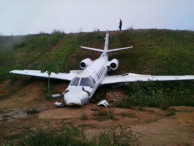
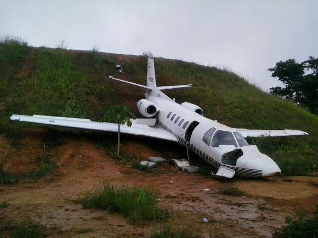
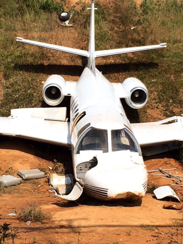
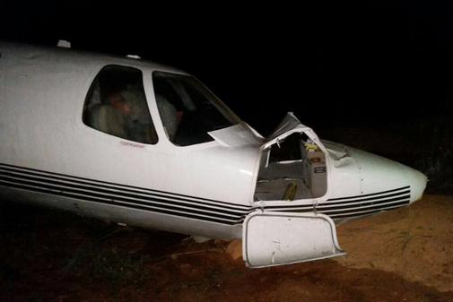
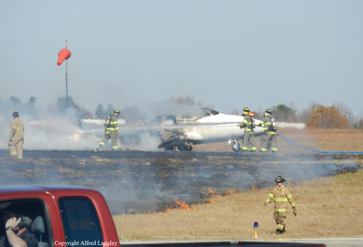
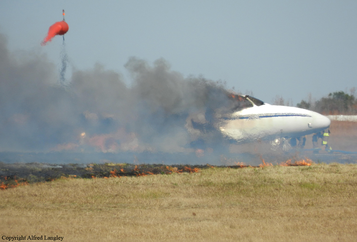
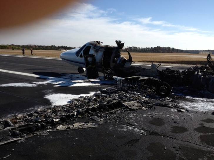
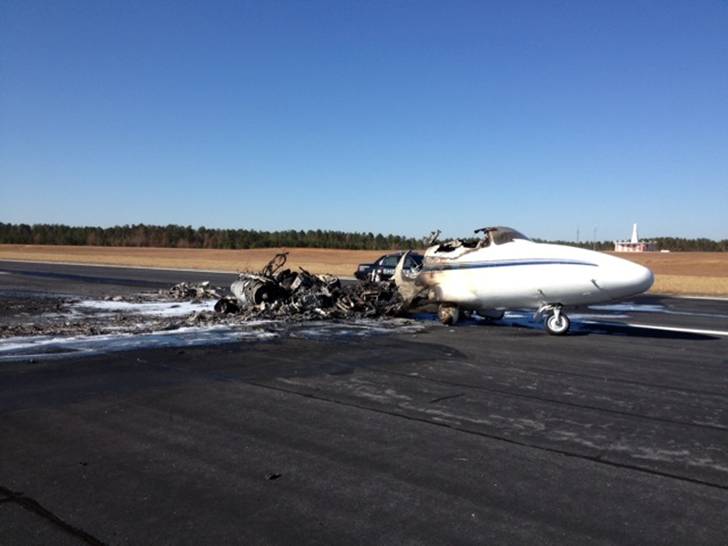
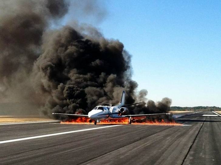
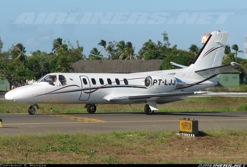
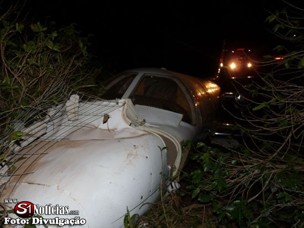
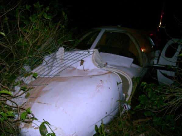
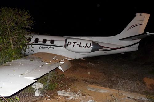
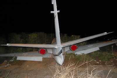
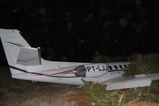
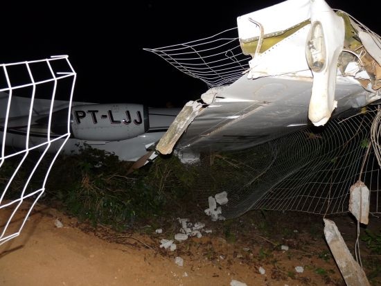
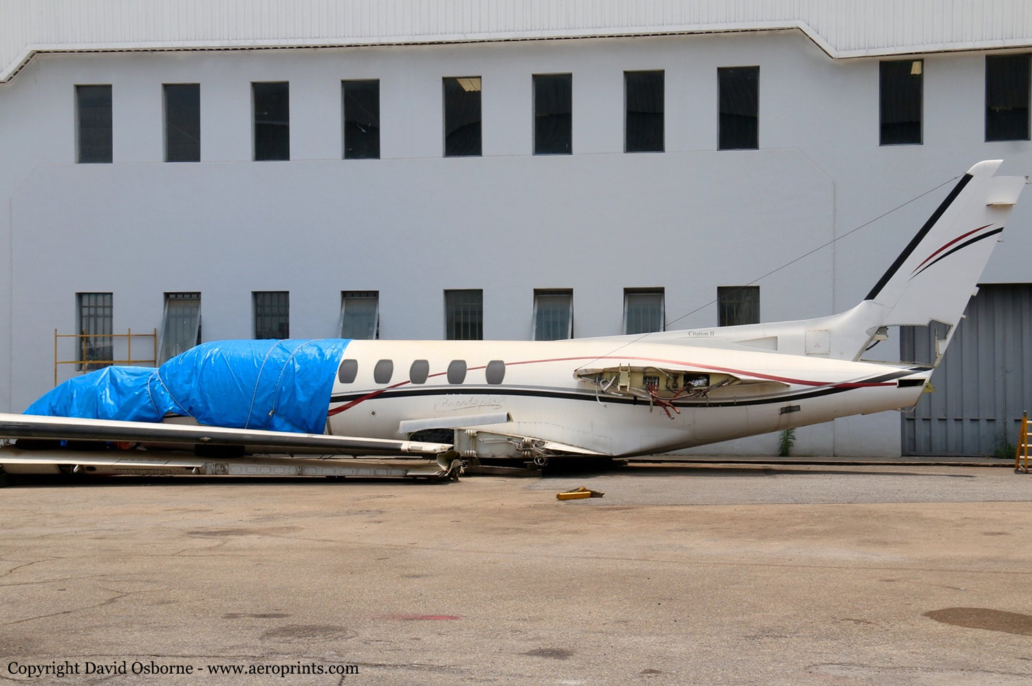
The aircraft, registered to the United States Customs Service, and operated by Stevens Aviation, Inc., was substantially damaged during collision with a deer after landing on Runway 9 at Greenwood County Airport (GRD), Greenwood, South Carolina. The airplane was subsequently consumed by postcrash fire. The two certificated airline transport pilots were not injured. Visual meteorological conditions prevailed, and no flight plan was filed for the maintenance test flight, which was conducted under the provisions of Title 14 Code of Federal Regulations Part 91. According to the pilot, the purpose of the flight was to conduct a test of the autopilot and flight director systems on board the airplane, following a "cockpit modernization" their company had performed. The airplane completed the NDB/GPS RWY 27 instrument approach procedure and then circled to land on Runway 9. About 5 seconds into the landing rollout, a deer appeared from the wood line and ran into the path of the airplane. The deer struck the airplane at the leading edge of the left wing above the left main landing gear, and ruptured an adjacent fuel cell. The pilot was able to maintain directional control, and the airplane was stopped on the runway, spilling fuel and on fire. The crew performed an emergency shutdown of the airplane and egressed without injury.Greenwood County Airport did not have a fire station co-located on the airport facility. The fixed base operator called 911 at the time of the accident, and the fire trucks arrived approximately 10 minutes after notification.
Probable cause:
Collision with a deer during the landing roll, which resulted in a compromised fuel tank and a postimpact fire. In a telephone interview, the manager of the Greenwood County Airport explained that Greenwood was not an FAR Part 139 Airport, and while there was no published Wildlife Management Program for the airport, she had been very proactive about eradicating wildlife that could pose a hazard to safety on the airport property, primarily deer and wild turkey. She contacted the United States Department of Agriculture (USDA) for guidance and advice and she attended a wildlife management course. Among the suggestions offered by the USDA, was to remove the deer habitat. The manager proposed adding the area between the runway and taxiway to an approach clearing project in order to reduce the habitat. The manager worked with a local charity and local hunters with depredation permits to take deer on the airport property, and their efforts averaged 50 deer a year. The hunts were conducted in stands away from runways and on property not aviation related. The nearest deer stand was 1 mile from the runway, and the hunters fired only shotguns. The hunts were conducted between the hours of 0700 and 1000. On the morning of the accident, the last shot was fired at 0930.When asked why the hunters were still on the property at the time of the accident, the manager said they had stayed to eat lunch, and repeated that the hunt was long over and that the last shot was fired hours before the accident. She offered that the deer struck by the airplane was probably flushed from the woods by another deer or a coyote, whose population has also grown in recent years.After the accident, the Federal Aviation Administration contacted the state and had the Greenwood County Airport added to a list of airports where funding for improvements had been allotted. A second 10-foot perimeter fence was added around the existing 6-foot fence, and since its construction only 4 deer have been taken inside the perimeter, and no wild turkeys have been sighted
Final Report:

Crash of a Cessna S550 Citation S/II in Warroad

Date & Time: Nov 11, 2011 at 2130 LT
Type of aircraft:
Registration:
N600KM
Survivors:
Yes
MSN:
S550-0008
YOM:
1984
Crew on board:
0
Crew fatalities:
Pax on board:
0
Pax fatalities:
Other fatalities:
Total fatalities:
0
Circumstances:
After a night landing on runway 13 at Warroad Airport, the aircraft collided with a White-tailed deer. The crew was able to stop the aircraft that suffered structural damages to the left wing. There were no injuries but the aircraft was damaged beyond repair.
Probable cause:
No investigation was conducted by NTSB.

Crash of a Cessna 550 Citation II in Manhuaçu

Date & Time: Oct 7, 2011 at 1738 LT
Type of aircraft:
Registration:
PT-LJJ
Survivors:
Yes
Schedule:
Belo Horizonte – Manhuaçu
MSN:
550-0247
YOM:
1981
Country:
Crew on board:
2
Crew fatalities:
Pax on board:
3
Pax fatalities:
Other fatalities:
Total fatalities:
0
Captain / Total flying hours:
4300
Captain / Total hours on type:
1200.00
Copilot / Total flying hours:
8000
Copilot / Total hours on type:
100
Circumstances:
The aircraft departed Belo Horizonte-Pampulha on an executive flight to Manhuaçu, carrying two pilots and three passengers, among them the Brazilian singer Eduardo Costa. Following an uneventful flight, the crew started the descent to Manhuaçu-Elias Breder Airport. After touchdown on runway 02, the crew activated the reverse thrust systems but the aircraft did not decelerate as expected. So the crew started to brake when the tires burst. Unable to stop within the remaining distance, the aircraft overran, lost its undercarriage, collided with a fence and came to rest. There was no fire. All five occupants were rescued. Nevertheless, Eduardo Costa broke his nose and right hand during the accident.
Probable cause:
Late use of the normal brake systems on part of the crew after landing, causing the aircraft to overran. The captain had the habit of braking the aircraft while using the reverse thrust systems only in order to save the braking systems. Doing so, the use of the normal brakes was delayed.
Final Report:

Crash of a Cessna 550 Citation II in Manas: 3 killed

Date & Time: Mar 28, 2011 at 1945 LT
Type of aircraft:
Operator:
Registration:
B-7026
Flight Phase:
Survivors:
No
Site:
Schedule:
Korla - Korla
MSN:
550-0305
YOM:
1982
Country:
Region:
Crew on board:
3
Crew fatalities:
Pax on board:
0
Pax fatalities:
Other fatalities:
Total fatalities:
3
Circumstances:
Owned by the Zhongfei General Aviation Company (CFGAC), the airplane was engaged in a survey flight over the north China province of Xinjiang. It departed Korla Airport at 1600LT with a crew of three. En route, it crashed in unknown circumstances in the Manas County, Hui autonomous prefecture of Changji. SAR did not find any trace of the aircraft nor the crew. Fatal index is presumed.

Crash of a Cessna 550 Citation II in Manteo

Date & Time: Oct 1, 2010 at 0830 LT
Type of aircraft:
Operator:
Registration:
N262Y
Survivors:
Yes
Schedule:
Tampa - Manteo
MSN:
550-0291
YOM:
1981
Crew on board:
2
Crew fatalities:
Pax on board:
5
Pax fatalities:
Other fatalities:
Total fatalities:
0
Captain / Total flying hours:
9527
Captain / Total hours on type:
2025.00
Copilot / Total flying hours:
3193
Copilot / Total hours on type:
150
Aircraft flight hours:
9643
Circumstances:
According to postaccident written statements from both pilots, the pilot-in-command (PIC) was the pilot flying and the copilot was the pilot monitoring. As the airplane approached Dare County Regional Airport (MQI), Manteo, North Carolina, the copilot obtained the current weather information. The automated weather system reported wind as 350 degrees at 4 knots, visibility at 1.5 miles in heavy rain, and a broken ceiling at 400 feet. The copilot stated that the weather had deteriorated from the previous reports at MQI. The PIC stated that they would fly one approach to take a look and that, if the airport conditions did not look good, they would divert to another airport. Both pilots indicated in phone interviews that, although they asked the Washington air route traffic control center controller for the global positioning system (GPS) runway 5 approach, they did not expect it due to airspace restrictions. They expected and received a GPS approach to runway 23 to circle-to-land on runway 5. According to the pilots' statements, the airplane was initially fast on approach to runway 23. As a result, the copilot could not deploy approach flaps when the PIC requested because the airspeed was above the flap operating range. The PIC subsequently slowed the airplane, and the copilot extended flaps to the approach setting. The PIC also overshot an intersection but quickly corrected and was on course about 1 mile prior to the initial approach fix. The airplane crossed the final approach fix on speed (Vref was 104) at the appropriate altitude, with the flaps and landing gear extended. The copilot completed the approach and landing checklist items but did not call out items because the PIC preferred that copilots complete checklists quietly. The PIC then stated that they would not circle-to-land due to the low ceiling. He added that a landing on runway 23 would be suitable because the wind was at a 90-degree angle to the runway, and there was no tailwind factor. Based on the reported weather, a tailwind component of approximately 2 knots existed at the time of the accident, and, in a subsequent statement to the Federal Aviation Administration, the pilot acknowledged there was a tailwind about 20 degrees behind the right wing. The copilot had the runway in sight about 200 feet above the minimum descent altitude, which was 440 feet above the runway. The copilot reported that he mentally prepared for a go around when the PIC stated that the airplane was high about 300 feet above the runway, but neither pilot called for one. The flight crew stated that the airplane touched down at 100 knots between the 1,000-foot marker and the runway intersection-about 1,200 feet beyond the approach end of the 4,305-foot-long runway. The speed brakes, thrust reversers, and brakes were applied immediately after the nose gear touched down and worked properly, but the airplane departed the end of the runway at about 40 knots. According to data extracted from the enhanced ground proximity warning system, the airplane touched down about 1,205 feet beyond the approach end of the 4,305-foot-long wet runway, at a ground speed of 127 knots. Data from the airplane manufacturer indicated that, for the estimated landing weight, the airplane required a landing distance of approximately 2,290 feet on a dry runway, 3,550 feet on a wet runway, or 5,625 feet for a runway with 0.125 inch of standing water. The chart also contained a note that the published limiting maximum tailwind component for the airplane is 10 knots but that landings on precipitation-covered runways with any tailwind component are not recommended. The note also indicates that if a tailwind landing cannot be avoided, the above landing distance data should be multiplied by a factor that increases the wet runway landing distance to 3,798 feet, and the landing distance for .125 inch of standing water to 6,356 feet. All distances in the performance chart are based on flying a normal approach at Vref, assume a touchdown point 840 feet from the runway threshold in no wind conditions, and include distance from the threshold to touchdown. The PIC's statement about the airplane being high at 300 feet above the runway reportedly prompted the copilot to mentally prepare for a go around, but neither pilot called for one. However, the PIC asked the copilot what he thought, and his reply was " it's up to you." The pilots touched down at an excessive airspeed (23 knots above Vref), more than 1,200 feet down a wet 4,305-foot-long runway, leaving about 3,100 feet for the airplane to stop. According to manufacturer calculations, about 2,710 feet of ground roll would be required after the airplane touched down, assuming a touchdown speed at Vref; a longer ground roll would be required at higher touchdown speeds. Although a 2 knot crosswind component existed at the time of the accident, the airplane's excessive airspeed at touchdown (23 knots above Vref) had a much larger effect on the outcome of the landing.
Probable cause:
The pilot-in-command's failure to maintain proper airspeed and his failure to initiate a go-around, which resulted in the airplane touching down too fast on a short, wet runway and a subsequent runway overrun. Contributing to the accident was the copilot's failure to adequately monitor the approach and call for a go around and the flight crew's lack of proper crew resource management.
Final Report:

Crash of a Cessna 550 Citation II in Bwagaoia: 4 killed

Date & Time: Aug 31, 2010 at 1615 LT
Type of aircraft:
Registration:
P2-TAA
Survivors:
Yes
Schedule:
Port Moresby – Bwagaoia
MSN:
550-0145
YOM:
1980
Region:
Crew on board:
2
Crew fatalities:
Pax on board:
3
Pax fatalities:
Other fatalities:
Total fatalities:
4
Captain / Total flying hours:
14591
Copilot / Total flying hours:
872
Aircraft flight hours:
14268
Circumstances:
The aircraft was conducting a charter flight from Jackson’s International Airport, Port Moresby, National Capital District, Papua New Guinea (PNG), to Bwagaoia Aerodrome, Misima Island, Milne Bay Province, PNG (Misima). There were two pilots and three passengers on board for the flight. The approach and landing was undertaken during a heavy rain storm over Bwagaoia Aerodrome at the time, which resulted in standing water on the runway. This water, combined with the aircraft’s speed caused the aircraft to aquaplane. There was also a tailwind, which contributed the aircraft to landing further along the runway than normal. The pilot in command (PIC) initiated a baulked landing procedure. The aircraft was not able to gain flying speed by the end of the runway and did not climb. The aircraft descended into terrain 100 m beyond the end of the runway. The aircraft impacted terrain at the end of runway 26 at 1615:30 PNG local time and the aircraft was destroyed by a post-impact, fuel-fed fire. The copilot was the only survivor. Other persons who came to assist were unable to rescue the remaining occupants because of fire and explosions in the aircraft. The on-site evidence and reports from the surviving copilot indicated that the aircraft was serviceable and producing significant power at the time of impact. Further investigation found that the same aircraft and PIC were involved in a previous landing overrun at Misima Island in February 2009.
Probable cause:
Contributing safety factors:
• The operator’s processes for determining the aircraft’s required landing distance did not appropriately consider all of the relevant performance factors.
• The operator’s processes for learning and implementing change from the previous runway overrun incident were ineffective.
• The flight crew did not use effective crew resource management techniques to manage the approach and landing.
• The crew landed long on a runway that was too short, affected by a tailwind, had a degraded surface and was water contaminated.
• The crew did not carry out a go-around during the approach when the visibility was less than the minimum requirements for a visual approach.
• The baulked landing that was initiated too late to assure a safe takeoff.
Other safety factors:
• The aircraft aquaplaned during the landing roll, limiting its deceleration.
• The runway surface was described as gravel, but had degraded over time.
• The weather station anemometer was giving an incorrect wind indication.
Final Report: