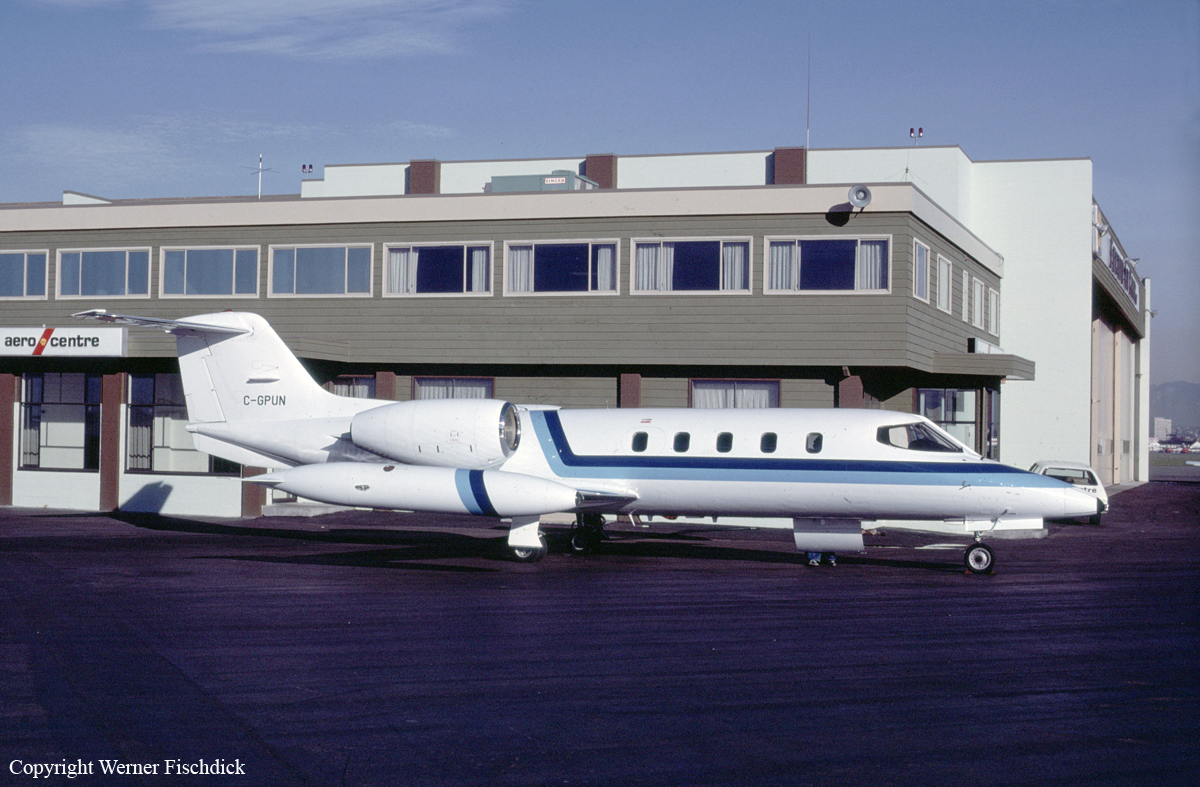
Crash of a Learjet 35 off Masset: 5 killed

Date & Time: Jan 11, 1995 at 0149 LT
Type of aircraft:
Operator:
Registration:
C-GPUN
Flight Type:
Survivors:
No
Schedule:
Vancouver - Masset
MSN:
35-058
YOM:
1976
Country:
Crew on board:
2
Crew fatalities:
Pax on board:
3
Pax fatalities:
Other fatalities:
Total fatalities:
5
Captain / Total flying hours:
4550
Captain / Total hours on type:
2550.00
Copilot / Total flying hours:
2880
Copilot / Total hours on type:
61
Aircraft flight hours:
11676
Circumstances:
On 11 January 1995, at 0035 Pacific standard time (PST), the twin-engine Learjet 35 departed Vancouver International Airport, British Columbia, on a night, instrument flight rules (IFR), medical evacuation (MEDEVAC) flight to the Masset aerodrome, on the northern end of the Queen Charlotte Islands. On board the Learjet were a flight crew of two pilots, and a medical team consisting of two attendants and a doctor. Their mission was to evacuate a patient from Masset and deliver her to Prince Rupert for treatment; the aircraft was then to return to Vancouver. The flight-planned route was at flight level (FL) 390, direct to Sandspit then direct to Masset. Following routine communications with Air Traffic Services (ATS), at about 0144, the aircraft reported "outbound" from the Masset non-directional beacon (NDB) on the published NDB "A" instrument approach procedure to runway 12. Air Traffic Control (ATC) radar, situated near Sandspit, tracked the aircraft as it flew the approach. Radar data shows that the aircraft began a descent about 10 seconds after it had completed the procedure turn and was established on the final inbound approach track. Forty-three seconds later, at a point 8.8 nautical miles (nm) from the threshold of runway 12 and on the final, inbound track, the aircraft disappeared from radar. Department of National Defence (DND) Search and Rescue (SAR) aircraft began searching the area shortly after the aircraft was declared missing, and were later assisted by other private and military aircraft and vessels. On the second day of the search, flotsam from the aircraft was found in the area. Extensive underwater searching using sonar and underwater cameras found the aircraft wreckage on 31 January 1995, in 260 feet of water, near the last known position. The aircraft had been destroyed. The bodies of two occupants were found several days after the accident, but the other three occupants have not been found and are presumed to have been fatally injured. The accident occurred at latitude 54/08NN and longitude 131/58NW, at about 0149 PST, during the hours of darkness in unknown weather conditions.
Probable cause:
The crew most likely conducted the instrument approach with reference to an unintentionally mis-set altimeter of 30.17 in. Hg, and unknowingly flew the aircraft into the water. The circumstances leading to the incorrect altimeter setting could not be determined, nor was it determined why the crew did not detect the mis-set altimeter.
Final Report:

Crash of a Cessna 414 Chancellor in Taft: 1 killed

Date & Time: Jul 19, 1994 at 1420 LT
Type of aircraft:
Registration:
N414RH
Flight Phase:
Flight Type:
Survivors:
Yes
Schedule:
Taft - Fresno
MSN:
414-0457
YOM:
1974
Location:
Crew on board:
3
Crew fatalities:
Pax on board:
1
Pax fatalities:
Other fatalities:
Total fatalities:
1
Captain / Total flying hours:
10000
Aircraft flight hours:
3739
Circumstances:
The emergency medical service (EMS/medevac) flight was dispatched to transport a patient in response to a medical emergency. During arrival to the destination, the pilot contacted the airport unicom for advisories and was advised to land on runway 25. Runway 25 had a 2.2 percent uphill grade and was restricted to landings only. After landing, the airplane was refueled and the patient was put on board. The pilot back-taxied on runway 25 and proceeded to take off uphill with the airplane near its maximum gross weight. According to ground witnesses, there was a tailwind, which they estimated was between 4 and 15 knots. The temperature was about 100 degrees, and the density altitude was about 3,200 feet. After the airplane became airborne, the pilot started an immediate left turn to avoid rising terrain. However, the left tip tank contacted the ground, and the airplane cartwheeled. It came to rest about 711 feet from the departure end of the runway. The flaps and landing gear were found fully extended; the published configuration for takeoff data in the flight manual was for 'wing flaps - up.' The airport had no signs to indicate runway use restrictions; however, the restrictions were published in the airport facility directory.
Probable cause:
The pilot's inadequate preflight planning/preparation and selection of the wrong runway for takeoff. Factors related to the accident were: the uphill slope of the runway, tailwind, high density altitude, and failure of the pilot to correctly configure the flaps for takeoff.
Final Report:

Crash of a Swearingen SA26T Merlin IIA in Thompson: 2 killed

Date & Time: Jun 1, 1994 at 0001 LT
Type of aircraft:
Operator:
Registration:
C-FFYC
Flight Type:
Survivors:
Yes
Schedule:
Coral Harbour – Churchill – Thompson
MSN:
T26-36
YOM:
1969
Country:
Crew on board:
2
Crew fatalities:
Pax on board:
1
Pax fatalities:
Other fatalities:
Total fatalities:
2
Captain / Total flying hours:
20000
Captain / Total hours on type:
3160.00
Copilot / Total flying hours:
3700
Copilot / Total hours on type:
375
Aircraft flight hours:
12633
Circumstances:
The twin-engine turboprop aircraft had just completed a medical evacuation (MEDEVAC) flight from Coral Harbour, Northwest Territories (NWT), to Churchill, Manitoba. At 2257 central daylight saving time (CDT), the aircraft departed Churchill for a night, instrument flight rules (IFR) flight to return to the aircraft's base of operations at Thompson, Manitoba. The en route portion of the return leg was conducted at an altitude of 18,000 feet above sea level (asl). Approximately one hour after take-off, the aircraft commenced an approach to the Thompson Airport. The crew remained in radio contact with air traffic control (ATC) personnel until approximately 2359 CDT. Just after midnight (0001 CDT), the Hotel non-directional beacon (NDB), which is located 3.4 miles northeast of the Thompson Airport, stopped transmitting. Ninety minutes later, the search and rescue satellite system (SARSAT) picked up an emergency locator transmitter (ELT) signal to the northeast of the airport. Thompson Airport staff, who had been dispatched to the site of the failed navigation beacon, found the wreckage of the aircraft in and around the NDB transmitter compound. Emergency responses were initiated by various airport and local authorities.
Probable cause:
The flight crew lost altitude awareness during the localizer back course approach and allowed the aircraft to descend below a mandatory level-off altitude. Contributing factors to this occurrence were the crew's deviation from a published approach procedure, ineffective in-flight monitoring of the approach, rapidly developing localized fog conditions, and, probably, pilot fatigue.
Final Report:

Crash of a Mitsubishi MU-2B-60 Marquise off Papeete: 5 killed

Date & Time: May 27, 1994 at 2354 LT
Type of aircraft:
Registration:
F-GDHV
Flight Type:
Survivors:
No
Schedule:
Rarotonga - Papeete
MSN:
779
YOM:
1980
Location:
Region:
Crew on board:
1
Crew fatalities:
Pax on board:
4
Pax fatalities:
Other fatalities:
Total fatalities:
5
Circumstances:
The aircraft was completing an ambulance flight from Rarotonga (Cook Islands) to Tahiti, carrying to Australian patients, two doctors and one pilot. On final approach to Papeete-Faaa Airport runway 04 by night, the twin engine aircraft descended too low and crashed in the sea about 6,4 km short of runway. The pilot did not send any distress call prior to impact and the aircraft struck the water surface in a flat attitude. All five occupants were killed. For unknown reasons, the pilot failed to realize his altitude was insufficient on short final. The lack of visibility and visual references were considered as contributing factors.

Crash of a Piper PA-31-350 Navajo Chieftain in Elizabethton: 2 killed

Date & Time: Apr 7, 1994 at 0810 LT
Operator:
Registration:
N64LB
Flight Type:
Survivors:
No
Schedule:
Augusta - Elizabethton
MSN:
31-7852127
YOM:
1978
Crew on board:
1
Crew fatalities:
Pax on board:
1
Pax fatalities:
Other fatalities:
Total fatalities:
2
Captain / Total flying hours:
7800
Aircraft flight hours:
2910
Circumstances:
The ATP and his passenger were en route to pick up a patient for transport to a VA hospital. The destination airport was uncontrolled, and VFR only. The pilot cancelled with ATC and reported the field in sight. The airport was reporting VFR conditions, but rising, mountainous terrain existed to the northeast, and local authorities reported that the top third of the mountain was obscured in clouds during the morning of the accident. After cancelling IFR, no subsequent radio calls were received from the flight, and the flight did not arrive at its destination. The wreckage was found several hours later near the crest of holston mountain, 1/2 mile east of the Holston mountain VOR. An examination of the wreckage indicated the aircraft impacted upsloping, wooded terrain, while at a climb angle of 8°. Disintegration of the wreckage was indicative of a high speed impact. No evidence of mechanical malfunction or failure was found during the examination of the wreckage. Both occupants were killed.
Probable cause:
The pilot's attempted VFR flight into imc conditions, and his failure to maintain a proper altitude over mountainous terrain. Factors were the clouds and obscuration at the accident site.
Final Report:

Crash of a Cessna 421C Golden Eagle III in San Antonio: 2 killed

Date & Time: Feb 10, 1994 at 0713 LT
Operator:
Registration:
N741CA
Flight Type:
Survivors:
Yes
Schedule:
San Antonio - Eagle Pass
MSN:
421C-0899
YOM:
1980
Crew on board:
1
Crew fatalities:
Pax on board:
2
Pax fatalities:
Other fatalities:
Total fatalities:
2
Captain / Total flying hours:
5100
Captain / Total hours on type:
400.00
Aircraft flight hours:
2916
Circumstances:
Shortly after takeoff, the pilot reported he had 'a problem' and needed to return immediately. Witnesses observed dark black smoke coming from both engines. The airplane collided with a tree 1/2-mile northeast of the runway threshold. Analysis of fuel samples revealed the presence of approximately 50% jet fuel. The right propeller was found feathered and engine disassembly revealed a hole burned in the right engine number 5 piston. Left engine disassembly revealed piston edges eroded down to the first compression ring. Fuel filler restrictors had been installed in the airplane's fuel tanks, but the fuel truck did not have the restrictive mating nozzle. The fuel truck was owned by the fuel vender and leased to the FBO.
Probable cause:
Improper servicing of the airplane with jet fuel, which resulted in preignition and/or detonation and subsequent failure of pistons in both engines. A factor related to the accident was: the lack of a restrictive mating nozzle on the refueling truck.
Final Report:

Crash of a Beechcraft C90 King Air in Augusta: 4 killed

Date & Time: Aug 7, 1993 at 1515 LT
Type of aircraft:
Operator:
Registration:
N90BP
Flight Type:
Survivors:
No
Schedule:
Adel - Augusta
MSN:
LJ-718
YOM:
1977
Crew on board:
1
Crew fatalities:
Pax on board:
3
Pax fatalities:
Other fatalities:
Total fatalities:
4
Captain / Total flying hours:
1875
Captain / Total hours on type:
300.00
Aircraft flight hours:
3301
Circumstances:
The instrument flight was cleared for an ILS approach to the destination airport. While maneuvering for the final approach course, the flight encountered convective activity (thunderstorms). The pilot was questioned by the tower concerning his position on the approach course. The tower radar placed the flight's position 1/4 to 1/2 mile east of the final approach course. The pilot stated that he was on the localizer. Subsequent functional checks of the ils system by air ways facilities, failed to reveal a problem with the ils approach system. The airplane collided with trees about one and one half miles northeast of the airport and one half mile east of the approach course. Weather reports recorded level four thunderstorm activity within the immediate vicinity of the destination airport. Wreckage examination failed to disclose any mechanical problems with the airplane. The air traffic controllers provided the pilot with current weather conditions at the airport throughout the final minutes of the flight, therefore the pilot was aware of the thunderstorm activity near and at the airport. All four occupants were killed.
Probable cause:
Was the pilot's failure to adequately evaluate inflight weather conditions which resulted in a loss of control when the airplane encountered a thunderstorm.
Final Report:

Crash of a Mitsubishi MU-2B-35 Marquise in Casper: 4 killed

Date & Time: Apr 6, 1993 at 0435 LT
Type of aircraft:
Operator:
Registration:
N96JP
Flight Type:
Survivors:
No
Site:
Schedule:
Riverton - Casper
MSN:
556
YOM:
1972
Crew on board:
1
Crew fatalities:
Pax on board:
3
Pax fatalities:
Other fatalities:
Total fatalities:
4
Captain / Total flying hours:
12360
Captain / Total hours on type:
205.00
Aircraft flight hours:
4781
Circumstances:
The aircraft was on an air ambulance (EMS) flight and was cleared for the ILS runway 08 approach at Casper, WY. Radar data showed the aircraft tracking and descending normally on the DME arc, until it was below radar coverage for the area. Subsequently, it collided with the top of a ridge, along the localizer centerline, before reaching the outer marker, about 8 miles from the airport. Elevation of the crash site was about 5,800 feet; minimum descent altitude before intercepting the ILS glide slope was 7,100 feet; crossing altitude at the outer marker was 6,700 feet. All four occupants were killed, a patient, two doctors and a pilot.
Probable cause:
Failure of the pilot to maintain proper altitude during the night ifr approach in instrument meteorological conditions (IMC).
Final Report:

Crash of a Cessna 421C Golden Eagle III in Eagle Mountain: 3 killed

Date & Time: Mar 11, 1993 at 2020 LT
Operator:
Registration:
N2656N
Flight Phase:
Flight Type:
Survivors:
No
Schedule:
Bermuda Dunes - Parker
MSN:
421C-0714
YOM:
1979
Crew on board:
1
Crew fatalities:
Pax on board:
2
Pax fatalities:
Other fatalities:
Total fatalities:
3
Captain / Total flying hours:
3250
Captain / Total hours on type:
500.00
Aircraft flight hours:
4869
Circumstances:
A Cessna 421 crashed after an inflight breakup. Investigation disclosed that the left outboard portion of the elevator assembly (including the balance weight) separated first, resulting in empennage flutter and subsequent in-flight breakup of the empennage. The left elevator outboard hinge and support structure exhibited evidence of hinge overtravel. The left horizontal stabilizer front spar had failed downward; rivets that attached the left outboard hinge to the rear spar of the left stabilizer had sheared; and the left elevator center hinge had been pulled off the rear spar. About 100 flight hours before the accident, maintenance was performed to repair the left elevator balance weight (which was loose) and to repair a damaged stiffener in the center structure of the horizontal stabilizer. However, when examined after the accident, the balance weight was tight and the repair to the stiffener was intact. All three occupants were killed.
Probable cause:
Failure of the left elevator for undetermined reason(s), which resulted in flutter and failure of the empennage, and subsequent uncontrolled collision with the terrain.
Final Report:

Crash of a Rockwell Grand Commander 690 in Herlong: 2 killed

Date & Time: Dec 31, 1992 at 1536 LT
Operator:
Registration:
N300CP
Flight Phase:
Flight Type:
Survivors:
No
Site:
Schedule:
Reno - Susanville
MSN:
690-11374
YOM:
1977
Crew on board:
1
Crew fatalities:
Pax on board:
1
Pax fatalities:
Other fatalities:
Total fatalities:
2
Captain / Total flying hours:
6984
Captain / Total hours on type:
782.00
Aircraft flight hours:
4052
Circumstances:
The pilot and flight nurse were en route to pick up a medical patient. The airplane experienced an in-flight breakup while flying by the leeward side of the sierra nevada mountains in the general area where standing lenticular clouds had been observed. No evidence was found that the pilot obtained a weather briefing from flight service or the duat vendors prior to departure. Pilots flying in the general area had reported airspeed variances from plus 60 to minus 40 knots. An in-flight weather advisory for occasional moderate turbulence was in effect. About one hour after the accident the weather service issued a sigmet for severe turbulence. Cause: an inadvertent encounter with severe turbulence which exceeded the design strength of the airplane's structure. Both occupants were killed.