Country
code
AK
Crash of a Cessna 208B Grand Caravan in Atqasuk
Date & Time:
Apr 11, 2018 at 0818 LT
Operator:

Registration:
N814GV
Survivors:
Yes
Schedule:
Utqiagvik – Atqasuk
MSN:
208B-0958
YOM:
2002
Crew on board:
1
Crew fatalities:
Pax on board:
0
Pax fatalities:
Other fatalities:
Total fatalities:
0
Aircraft flight hours:
9778
Circumstances:
The pilot was on a visual flight rules flight transporting mail to a remote village. He reported that when he was about 15 minutes from the destination, he checked the automated weather observing system (AWOS) for updated weather information for the destination and recalled that the visibility was reported as 7 miles. However, the information he recalled was not consistent with what was actually reported by the AWOS; 18 minutes before the accident, the AWOS reported no more than 1 3/4 miles visibility. As he descended the airplane from 2,500 ft to 1,500 ft in the terminal area, he observed reduced visibility conditions that would require an instrument approach procedure. According to the pilot, while maneuvering toward the initial approach fix, he heard the autopilot disconnect, and the airplane began an uncommanded descent. He said that he remembered pulling on the control wheel and thought he had leveled off, but then the airplane impacted terrain, which resulted in substantial damage to the fuselage, vertical stabilizer, and rudder. He could not recall if he had heard terrain warnings or alerts before the impact. An airplane performance study indicated that the airplane was in a continuous descent from 2,500 ft until the final data point about 12 ft above the surface; the airplane was not leveled off at any time during the descent. In the final 15 seconds of recorded data, the rate of descent increased from about 500 fpm to about 2,300 fpm before decreasing to 1,460 fpm at the last recorded data point. Postaccident examinations of the airframe, engine, flight control, and autopilot components revealed no mechanical malfunctions or failures that would have precluded normal operation or affected flight controllability. It is likely that the unexpected instrument approach procedure increased the pilot's workload as he maneuvered to set up for the approach. Further, when the autopilot disconnected, the airplane continued to descend; although the pilot reported that he heard the autopilot disconnect, he did not arrest the airplane's descent rate. Given the low visibility conditions, it is likely that the pilot did not detect the airplane's descent, and the airplane descended into the terrain.
Probable cause:
The pilot's decision to continue a visual flight rules flight into an area of instrument meteorological conditions and his subsequent failure to level the airplane after the autopilot disconnected, which resulted in a collision with terrain.
Final Report:
Crash of a Cessna 207 Skywagon near Hope
Date & Time:
Jul 3, 2017 at 1032 LT
Operator:

Registration:
N9620M
Survivors:
Yes
Schedule:
Seldovia – Anchorage
MSN:
207-0711
YOM:
1981
Crew on board:
1
Crew fatalities:
Pax on board:
0
Pax fatalities:
Other fatalities:
Total fatalities:
0
Captain / Total hours on type:
3.00
Aircraft flight hours:
23833
Circumstances:
According to the pilot, he was flying the second airplane in a flight of two about 1 mile behind the lead airplane. The lead airplane pilot reported to him, via the airplane's radio, that he had encountered decreasing visibility and that he was making a 180° left turn to exit the area. The pilot recalled that, after losing sight of the lead airplane, he made a shallow climbing right turn and noticed that the terrain was rising. He recalled that he entered the clouds for a few seconds and "at that moment I ran into the trees which I never saw coming." The airplane sustained substantial damage to both wings. The pilot reported that there were no preaccident mechanical malfunctions or failures with the airplane that would have precluded normal operation. The pilot reported that the temperature was 60°F with 8 miles visibility and 1,500-eeft ceilings. The nearest METAR was about 1 mile away and reported that the temperature was 54°F, dew point was 52°F, visibility was 8 statute miles with light rain, and ceiling was broken at 500 feet and overcast at 1,500 feet.
Probable cause:
The pilot's inadvertent flight into instrument meteorological conditions and subsequent controlled flight into terrain.
Final Report:

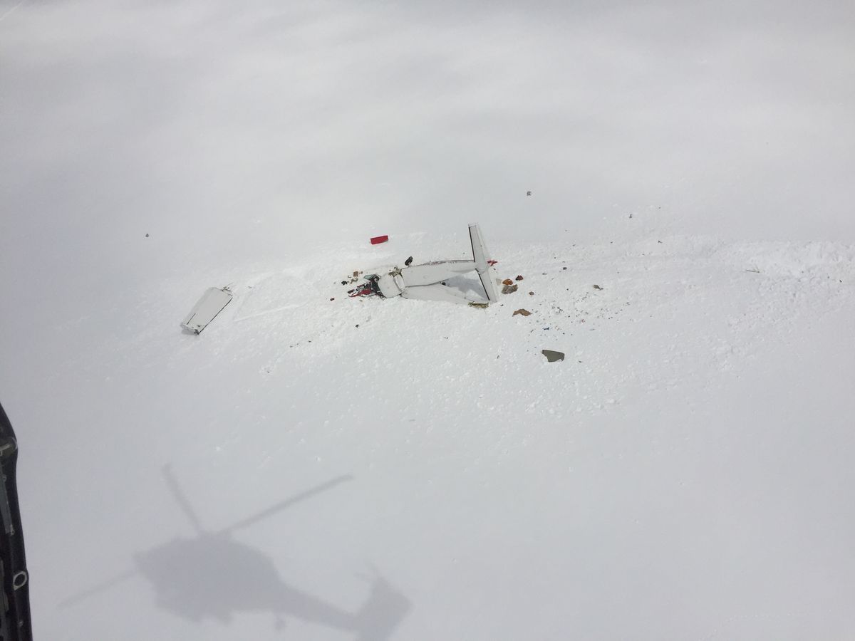
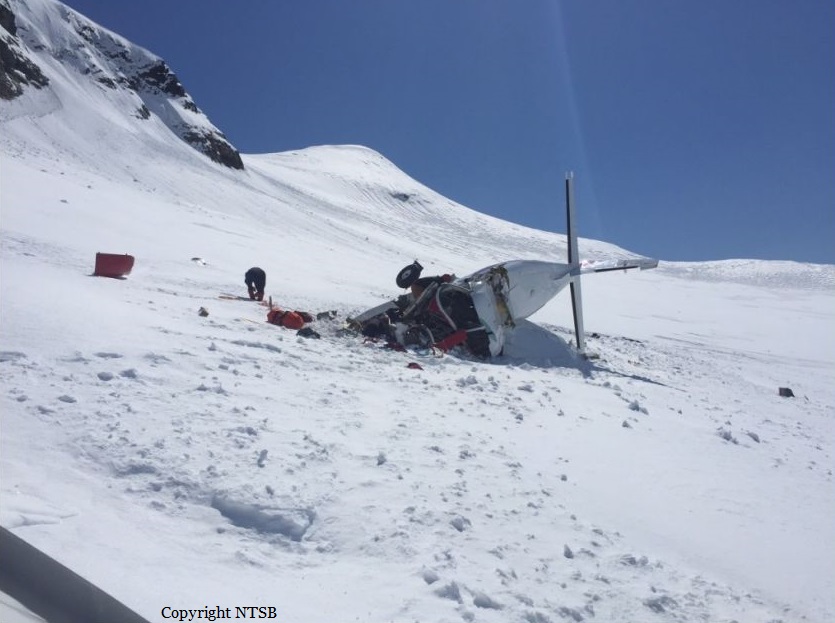
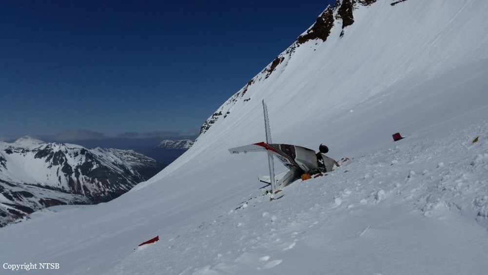
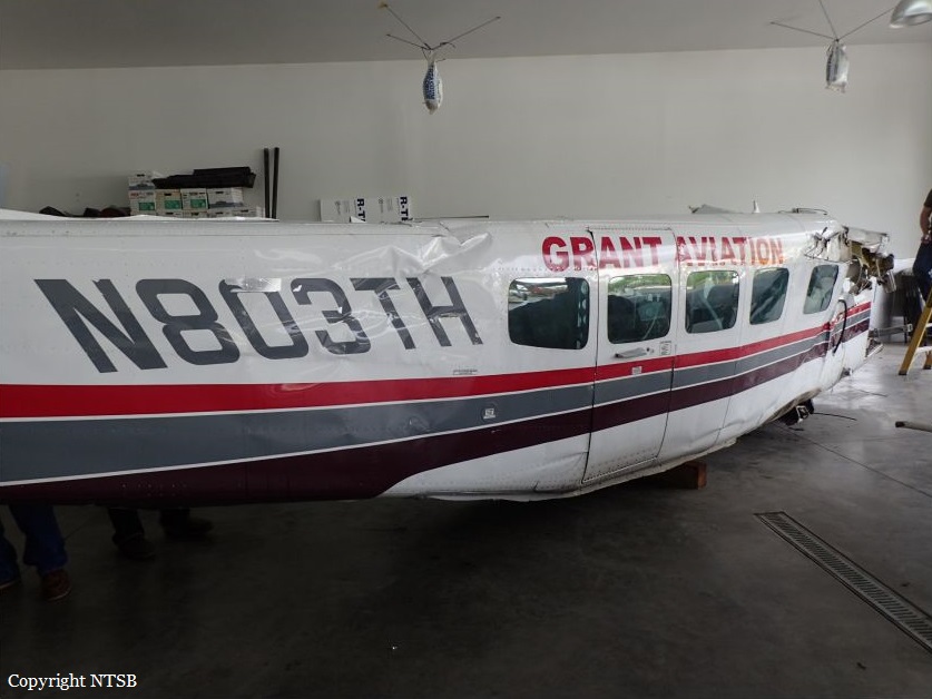
Crash of a Cessna 208B Grand Caravan near Chignik: 1 killed
Date & Time:
May 1, 2017 at 1350 LT
Operator:

Registration:
N803TH
Survivors:
No
Schedule:
Port Heiden - Perryville
MSN:
208B-0321
YOM:
1992
Flight number:
GV341
Crew on board:
1
Crew fatalities:
Pax on board:
0
Pax fatalities:
Other fatalities:
Total fatalities:
1
Captain / Total hours on type:
904.00
Aircraft flight hours:
17990
Circumstances:
The airline transport pilot was conducting a commercial visual flight rules (VFR) flight. A passenger who was on the first segment stated that the pilot flew the airplane lower than usual for that route, and that the airplane flew through clouds during the flight. The passenger disembarked and the pilot departed on the second segment of the flight with a load of mail. The route included flight across a peninsula of mountainous terrain to a remote coastal airport that lacked official weather reporting or instrument approach procedures. About 28 minutes after departure, an emergency locator transmitter (ELT) signal from the airplane was received and a search and rescue operation was initiated. The wreckage was located about 24 miles from the destination in deep snow on the side of a steep, featureless mountain at an elevation about 3,000 ft mean sea level. The accident site displayed signatures consistent with impact during a left turn. Examination of the airplane revealed no evidence of mechanical malfunctions or anomalies that would have precluded normal operation. The airplane was not equipped with any recording or flight tracking devices, nor was it required to be; therefore, the airplane's flight track before the accident could not be determined. The airplane was certified for instrument flight and flight in icing conditions and was equipped with a terrain avoidance warning system (TAWS) which was not inhibited during the accident. Although the TAWS should have provided the pilot with alerts as the airplane neared the terrain, it could not be determined if this occurred or if the pilot heeded the alerts. A review of nearby weather camera images revealed complete mountain obscuration conditions with likely rain shower activity in the vicinity of the accident site. Visible and infrared satellite imagery indicated overcast cloud cover over the accident site at the time of the accident. The graphical forecast products that were available to the pilot before the flight indicated marginal VFR conditions for the entire route. There was no evidence that the pilot obtained an official weather briefing, and what weather information he may have accessed before the flight could not be determined. Additionally, the cloud conditions and snow-covered terrain present in the area likely resulted in flat light conditions, which would have hindered the pilot's ability to perceive terrain features and closure rates. Based on the weather camera, surface, and upper air observations, it is likely that the pilot encountered instrument meteorological conditions inflight, after which he performed a left turn to return to visual meteorological conditions and did not recognize his proximity to the mountain due to the flat light conditions. The pilot and the dispatch agent signed a company flight risk assessment form before the flight, which showed that the weather conditions for the flight were within the company's acceptable risk parameters. Although the village agents at the departure and destination airports stated that the weather at those coastal locations was good, the weather assessment for the accident flight was based on hours-old observations provided by a village agent who was not trained in weather observation and did not include en route weather information, the area forecast, or the AIRMET for mountain obscuration effective during the dispatch time and at the time of the accident. Since acquiring the accident route from another operator years earlier, the company had not performed a risk assessment of the route and its associated hazards. Multiple company pilots described the accident route of flight as hazardous and considered it an undesirable route due to the terrain, rapidly changing weather, and lack of weather reporting infrastructure; however, the company did not address or attempt to mitigate these known hazards through its risk assessment processes. The company's controlled-flight-into-terrain (CFIT)-avoidance program stated that each pilot shall have one classroom training session and one CFIT-avoidance training session in an aviation training device (ATD) each year; however, the pilot's training records indicated that his most recent ATD session was 15 months prior. More recent CFIT avoidance training may have resulted in the pilot recognizing and responding to the reduced visibility and flat light conditions sooner.
Probable cause:
The pilot's continued visual flight rules flight into an area of mountainous terrain and instrument meteorological conditions, which resulted in controlled flight into terrain (CFIT). Contributing to the accident was the company's failure to provide the pilot with CFIT-avoidance recurrent simulator training as required by their CFIT avoidance program and the company's inadequate flight risk assessment processes, which did not account for the known weather hazards relevant to the accident route of flight.
Final Report:


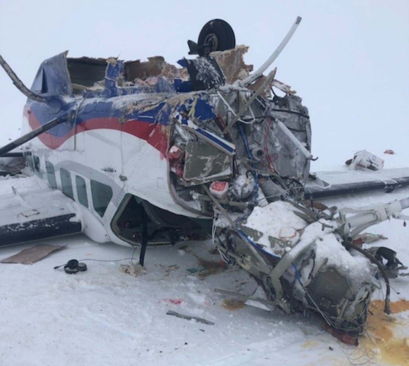
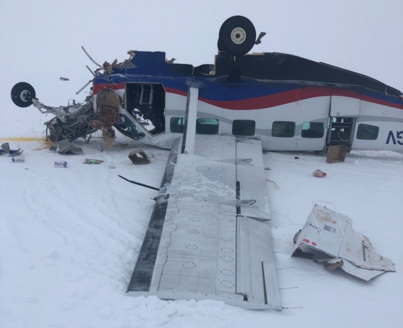
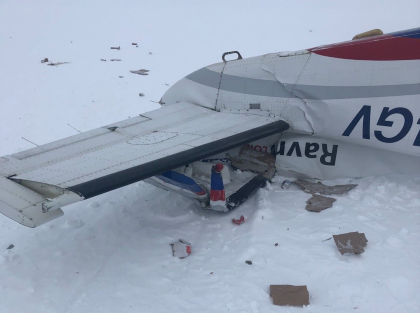
Crash of a Beechcraft G18S off Metlakatla
Date & Time:
Mar 3, 2017 at 0815 LT
Registration:
N103AF
Survivors:
Yes
Schedule:
Klawock – Ketchikan
MSN:
BA-526
YOM:
1960
Crew on board:
2
Crew fatalities:
Pax on board:
0
Pax fatalities:
Other fatalities:
Total fatalities:
0
Captain / Total hours on type:
330.00
Aircraft flight hours:
17646
Circumstances:
The pilot of the twin-engine airplane and the pilot-rated passenger reported that, during a missed approach in instrument meteorological conditions, at 2,000 ft mean sea level, the right engine seized. The pilot attempted to feather the right engine by pulling the propeller control to the feather position; however, the engine did not feather. The airplane would not maintain level flight, so the pilot navigated to a known airport, and the passenger made emergency communications with air traffic control. The pilot was unable to maintain visual reference with the ground until the airplane descended through about 100 to 200 ft and the visibility was 1 statute mile. The pilot stated that he was forced to ditch the airplane in the water about 5 miles short of the airport. The pilot and passenger egressed the airplane and swam ashore before it sank in about 89 ft of water. Both the pilot and passenger reported that there was postimpact fire on the surface of the water. The airplane was not recovered, which precluded a postaccident examination. Thus, the reason for the loss of engine power could not be determined.
Probable cause:
An engine power loss for reasons that could not be determined because the airplane was not recovered.
Final Report:

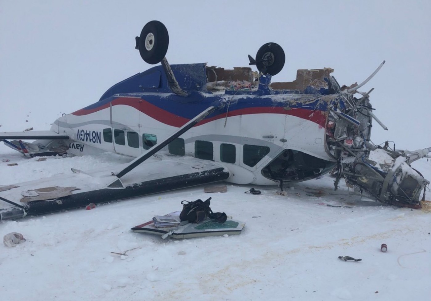
Crash of a Beechcraft B200 Super King Air in Unalaska
Date & Time:
Feb 14, 2017 at 1323 LT
Operator:
Registration:
N313HS
Survivors:
Yes
MSN:
BB-1300
YOM:
1988
Crew on board:
2
Crew fatalities:
Pax on board:
1
Pax fatalities:
Other fatalities:
Total fatalities:
0
Circumstances:
Following an uneventful flight, the aircraft belly landed at Unalaska-Tom Madsen Airport runway 13/31. The airplane slid for few dozen metres before coming to rest and was damaged beyond repair. All three occupants evacuated safely.
Probable cause:
There were no investigations about this event. Nevertheless, it was reported that the pilot was distracted and forgot to lower the landing gear on final approach.

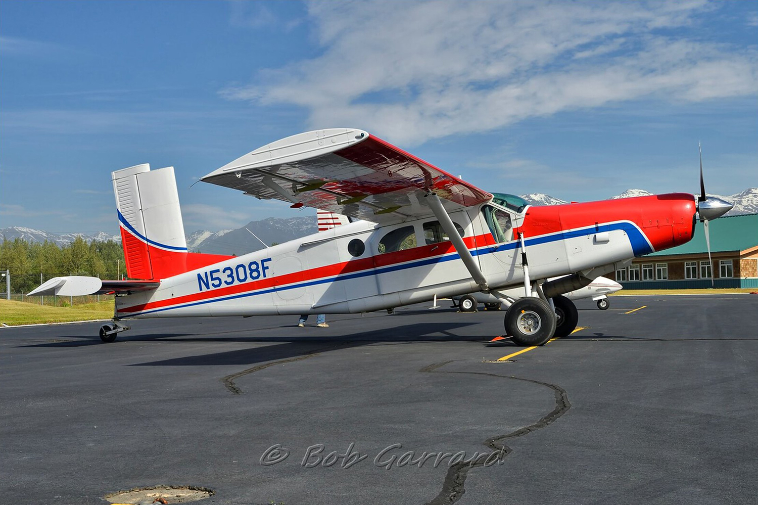
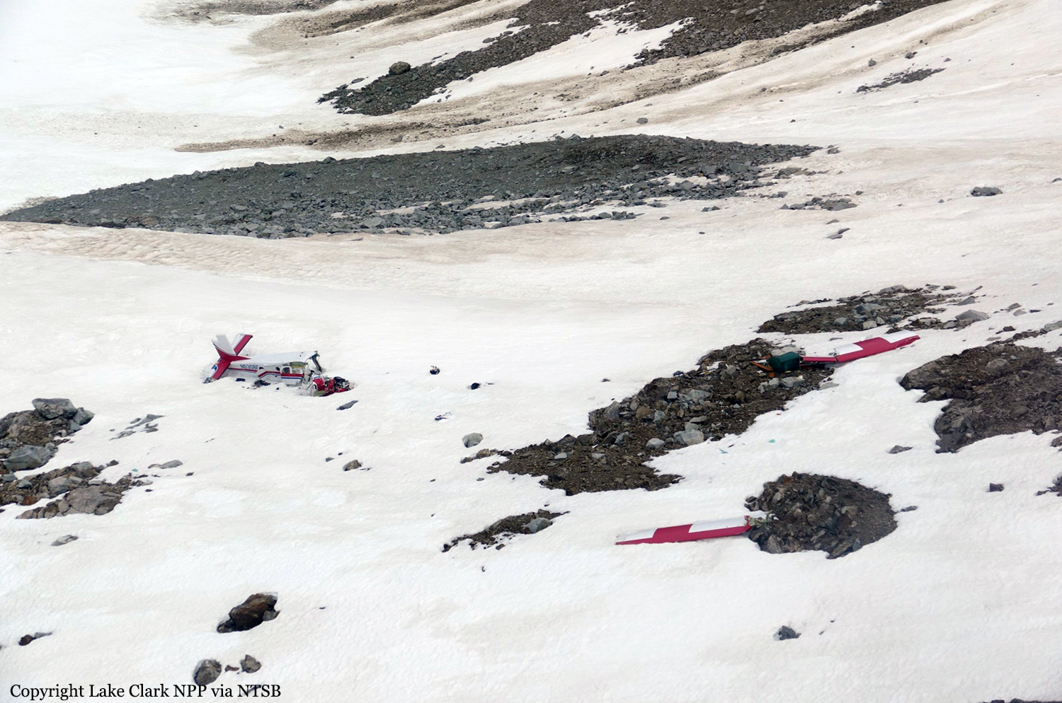
Crash of a Pilatus PC-6/C-H2 Turbo Porter near Port Alsworth: 1 killed
Date & Time:
Oct 28, 2016 at 1828 LT
Registration:
N5308F
Survivors:
No
Schedule:
Anchorage – Port Alsworth
MSN:
2068
YOM:
1975
Crew on board:
1
Crew fatalities:
Pax on board:
0
Pax fatalities:
Other fatalities:
Total fatalities:
1
Circumstances:
The commercial pilot was conducting a cross-country flight to a family residence in the turbinepowered, single-engine airplane. The pilot was familiar with the route, which traversed a mountain pass and remote terrain. Before departing on the flight, the pilot communicated with a family member at the residence via text messages and was aware the weather was windy but that the mountain tops were clear. There was no record of the pilot obtaining a preflight weather briefing from an official, accesscontrolled source, and the pilot indicated to a friend before departure that he had not accessed weather cameras. Weather forecast products that were available to the pilot revealed possible turbulence at low altitudes and icing at altitudes above 12,000 ft along the route of flight, and weather cameras along the planned route and near the destination would have indicated deteriorating visibility in snow showers and mountain obscuration starting about 1.5 hours before departure. The airplane departed and proceeded toward the destination; radar data correlated to the accident flight indicated that the airplane climbed from 4,600 ft to 14,700 ft before turning west over the mountains. Text messages that the pilot sent during the initial climb revealed that the mountain pass he planned to fly through was obscured, and he intended to climb over the mountains and descend through holes in the clouds as he neared the destination. Radar data also indicated that the airplane operated above 12,500 ft mean sea level (msl) for about 30 minutes, and above 14,000 msl for an additional 14 minutes before entering a gradual descent during the last approximate 20 minutes of flight. Review of weather information indicated that cloud layers over the accident area increased during the 30 minutes before the accident, and it is likely that the airplane was operating in icing conditions, although it was not certified for flight in such conditions, which may have resulted in structural or induction icing and an uncontrolled loss of altitude. The airplane wreckage came to rest on the steep face of a snow-covered mountain in a slight nose-down, level attitude. The empennage was intact, the right wing was completely separated, and the forward fuselage and cockpit were partially separated and displaced from the airframe with significant crush damage, indicative of impact with terrain during forward flight. Page 2 of 10 ANC17FA004 There was no indication that the airplane was equipped with supplemental oxygen; pilots are required to use oxygen when operating at altitudes above 12,500 ft for more than 30 minutes, and anytime at altitudes above 14,000 ft. It could not be determined if, or to what extent, the pilot may have experienced symptoms of hypoxia that would have affected his decision-making. The airplane wreckage was not recovered or examined due to hazardous terrain and environmental conditions, and the reason for the impact with terrain could not be determined; however, it is likely that deteriorating enroute weather and icing conditions contributed to the outcome of the accident.
Probable cause:
The airplane's collision with mountainous terrain while operating in an area of reduced visibility and icing conditions. Contributing to the accident was the pilot's inadequate preflight planning, which would have identified deteriorating weather conditions along the planned route of flight.
Final Report:
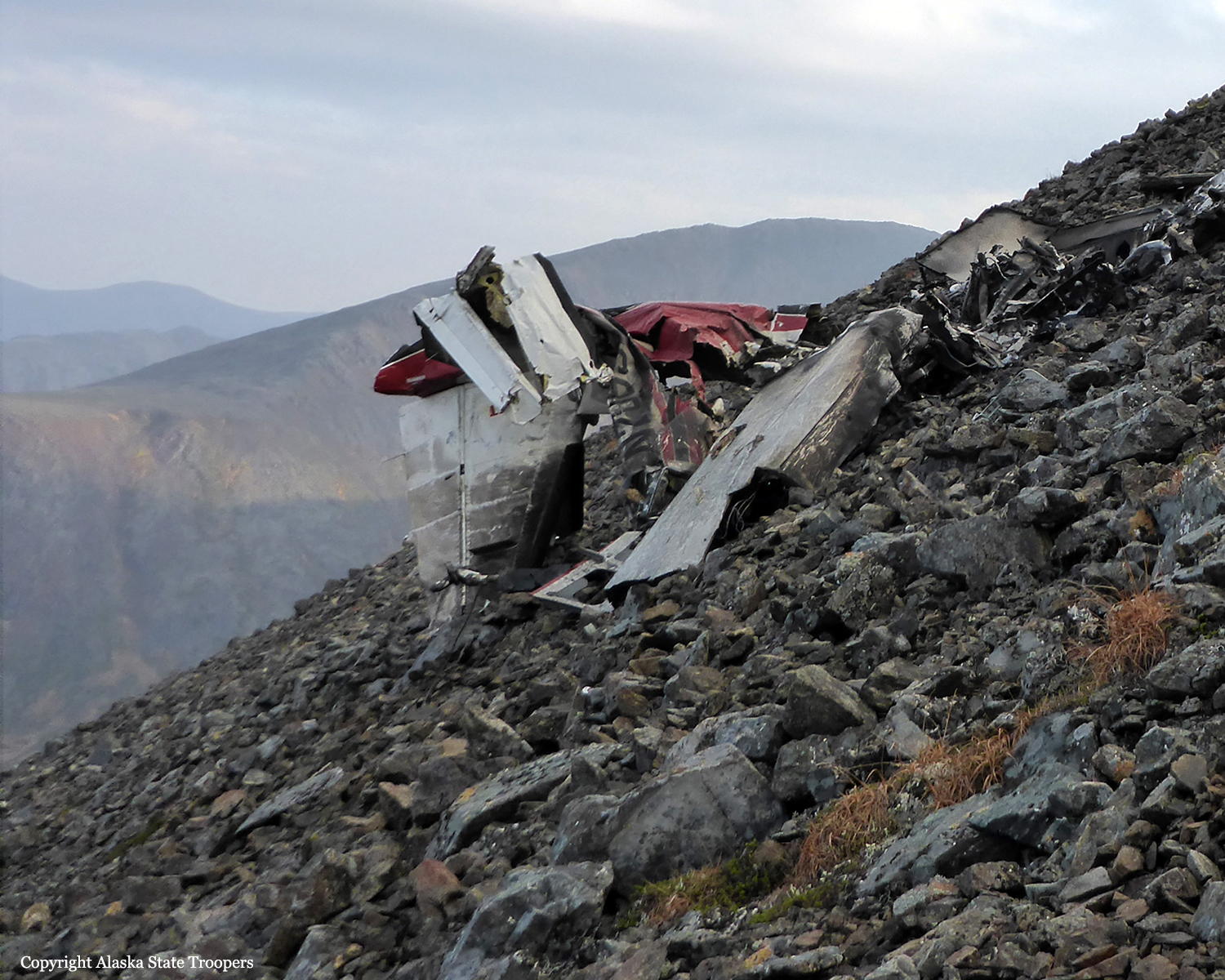
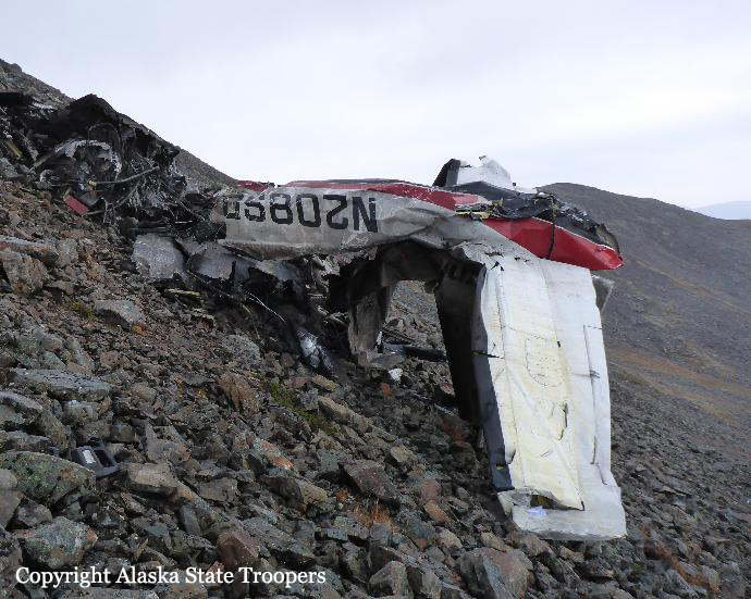
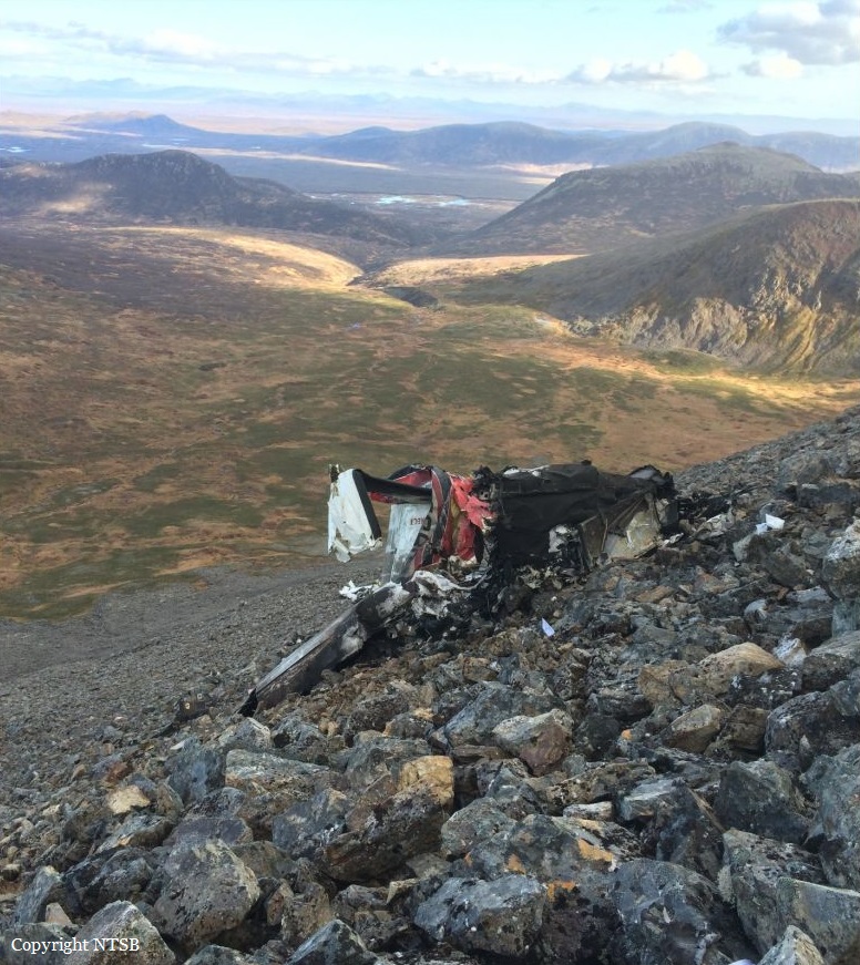
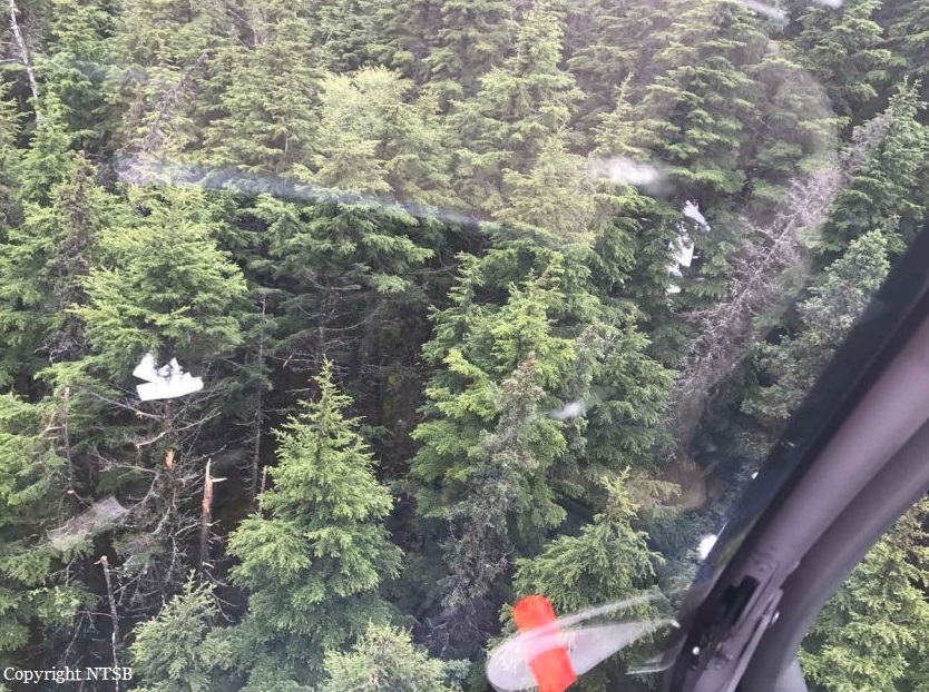
Crash of a Cessna 208B Grand Caravan near Togiak: 3 killed
Date & Time:
Oct 2, 2016 at 1157 LT
Operator:

Registration:
N208SD
Survivors:
No
Schedule:
Quinhagak – Togiak
MSN:
208B-0491
YOM:
1995
Flight number:
HAG3153
Crew on board:
2
Crew fatalities:
Pax on board:
1
Pax fatalities:
Other fatalities:
Total fatalities:
3
Captain / Total hours on type:
781.00
Copilot / Total hours on type:
84
Aircraft flight hours:
20562
Circumstances:
On October 2, 2016, about 1157 Alaska daylight time, Ravn Connect flight 3153, a turbine powered Cessna 208B Grand Caravan airplane, N208SD, collided with steep, mountainous terrain about 10 nautical miles northwest of Togiak Airport (PATG), Togiak, Alaska. The two commercial pilots and the passenger were killed, and the airplane was destroyed. The scheduled commuter flight was operated under visual flight rules by Hageland Aviation Services, Inc., Anchorage, Alaska, under the provisions of Title 14 Code of Federal Regulations Part 135. Visual meteorological conditions prevailed at PATG (which had the closest weather observing station to the accident site), but a second company flight crew (whose flight departed about 2 minutes after the accident airplane and initially followed a similar route) reported that they observed unexpected fog, changing clouds, and the potential for rain along the accident route. Company flight-following procedures were in effect. The flight departed Quinhagak Airport, Quinhagak, Alaska, about 1133 and was en route to PATG.
Probable cause:
The flight crew's decision to continue the visual flight rules flight into deteriorating visibility and their failure to perform an immediate escape maneuver after entry into instrument meteorological conditions, which resulted in controlled flight into terrain (CFIT). Contributing to the accident were:
- Hageland's allowance of routine use of the terrain inhibit switch for inhibiting the terrain awareness and warning system alerts and inadequate guidance for uninhibiting the alerts, which reduced the margin of safety, particularly in deteriorating visibility;
- Hageland's inadequate crew resource management (CRM) training;
- The Federal Aviation Administration's failure to ensure that Hageland's approved CRM training contained all the required elements of Title 14 Code of Federal Regulations 135.330;
- Hageland's CFIT avoidance ground training, which was not tailored to the company's operations and did not address current CFIT-avoidance technologies.
Final Report: