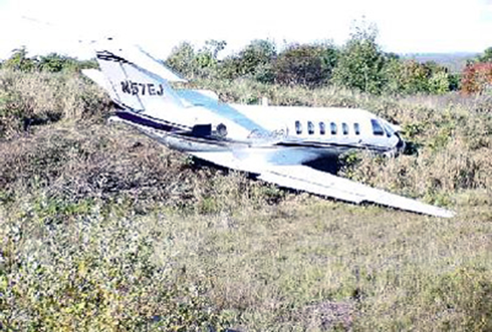
Crash of a Cessna 500 Citation I in Marília

Date & Time: Dec 1, 2002 at 2310 LT
Type of aircraft:
Registration:
PT-LIY
Survivors:
Yes
Schedule:
Goiânia – Marília
MSN:
500-0219
YOM:
1975
Country:
Crew on board:
2
Crew fatalities:
Pax on board:
5
Pax fatalities:
Other fatalities:
Total fatalities:
0
Captain / Total flying hours:
2200
Captain / Total hours on type:
1200.00
Copilot / Total flying hours:
1300
Copilot / Total hours on type:
200
Circumstances:
Following an uneventful flight from Goiânia-Santa Genoveva Airport, the crew started the descent to Marília Airport by night. Poor weather conditions at destination forced the crew to make a direct approach to runway 03. After landing, the aircraft was unable to stop within the remaining distance, overran, lost its undercarriage and came to rest in bushes 143 metres past the runway end. All seven occupants were rescued, among them four were injured. The aircraft was damaged beyond repair.
Probable cause:
Poor approach configuration on part of the crew who landed the aircraft 750 metres past the runway threshold, reducing the landing distance available. The following contributing factors were identified:
- The crew completed an unstabilized approach,
- Poor approach planning,
- Limited visibility due to the night and poor weather conditions,
- The braking action was low because the runway surface was wet,
- The crew failed to initiate a go-around procedure.
Final Report:

Crash of a Cessna 525A CitationJet CJ2 in Dexter

Date & Time: Oct 7, 2002 at 1017 LT
Type of aircraft:
Operator:
Registration:
N57EJ
Survivors:
Yes
Schedule:
Plainville - Dexter
MSN:
525A-0057
YOM:
2002
Location:
Crew on board:
2
Crew fatalities:
Pax on board:
2
Pax fatalities:
Other fatalities:
Total fatalities:
0
Captain / Total flying hours:
2450
Captain / Total hours on type:
872.00
Aircraft flight hours:
113
Circumstances:
The pilot/owner initiated a VFR approach and landing in a Cessna 525A, to a 3,009-foot long runway with a tailwind of about 7 knots. The touchdown was 642 feet past the approach end of the runway. Vref was calculated to be 108 kts; however, data from the EGPWS showed the ground speed was about 137 kts, 9 seconds before touchdown, and at touchdown, the speed was estimated to be about 130 kts. After touchdown, the pilot selected ground flaps, which moved the flaps from 35 degrees to 60 degrees, the spoilers auto-deployed, and the speed brakes were extended. The pilot said that after applying the brakes, he felt the brakes pedals pulsing, and did not think the airplane was slowing. He released the brakes for a few seconds and then reapplied them. Again, he felt the pulsing in the pedals, but the airplane was not slowing as he expected. He released the brakes, reset the flaps to takeoff, and applied power to abort the landing when he was about halfway down the runway. The airplane departed the end of the runway and traveled for about 300 feet. Skid marks revealed the initial touchdown was most like made with brakes applied, and no locked wheel crossover protection. Additional skid marks revealed the airplane became airborne after touchdown, and in the next 750 ft, touched down 3 more times, each subsequent touchdown occurring without the full weight of the airplane on the wheels. Tire marks on the last half of the runway were consistent with brakes applied and anti-skid operative. Using the approved flight manual standards, the airplane would have required 3,155 feet to stop. This was predicated on crossing the threshold at 50 feet, at Vref, and included a ground roll of 1,895 feet. However, the pilot touched down at 642 feet from the threshold, which left sufficient runway for stopping. Using the pilot's touchdown point of 642 feet, the airplane was capable of stopping on the runway with a Vref as high as 120 kts. The approach was unstabilized with 4 aural warnings, including 2 sink rate warnings on final approach, the last of which occurred with a descent rate of over 1,700 fpm down, 19 seconds prior to touchdown, and about 400 feet above the ground. The last airborne GPS position was about 2,000 ft from runway touchdown. This would have required a flight path angle of about 3.8 degrees to achieve the reported touchdown position.
Probable cause:
The pilot's improper decision to land with excessive speed, and his delayed decision to perform an aborted landing, both of which resulted in a runway overrun. A factor was the tailwind.
Final Report:

Crash of a Learjet 60 in Santa Cruz do Sul: 1 killed

Date & Time: Oct 7, 2002 at 0910 LT
Type of aircraft:
Operator:
Registration:
N5027Q
Survivors:
Yes
Schedule:
Marília – Santa Cruz do Sul
MSN:
60-242
YOM:
2002
Country:
Crew on board:
3
Crew fatalities:
Pax on board:
2
Pax fatalities:
Other fatalities:
Total fatalities:
1
Captain / Total flying hours:
3694
Captain / Total hours on type:
535.00
Copilot / Total flying hours:
1687
Circumstances:
The approach to Santa Cruz do Sul Airport was completed in poor weather conditions with rain falls. After touchdown on runway 26, the aircraft was unable to stop within the remaining distance. It overran and eventually collided with an embankment located 50 metres further and came to rest. The captain was seriously injured and the copilot was killed, all three other occupants escaped with minor injuries. The aircraft was destroyed. Runway 26 at Santa Cruz do Sul is 4,000 feet and it was determined that the aircraft landed some 400 metres past the runway threshold at an excessive speed.
Probable cause:
The following findings were identified:
- The visibility was reduced by rain falls,
- The runway surface was wet,
- The braking action was poor,
- The crew landed the aircraft too far down the runway, about 400 metres past the runway threshold, reducing the landing distance available,
- The aircraft's speed at touchdown was excessive,
- The copilot was inexperienced and did not have any training of qualification on such type of aircraft,
- Lack of crew coordination,
- Poor crew resources management,
- Uncomplete approach briefing.
Final Report:

Crash of a Pilatus PC-12/45 in Westphalia: 2 killed

Date & Time: Sep 14, 2002 at 1555 LT
Type of aircraft:
Registration:
N451ES
Flight Phase:
Survivors:
No
Schedule:
Lake Ozark – South Bend
MSN:
425
YOM:
2001
Crew on board:
1
Crew fatalities:
Pax on board:
1
Pax fatalities:
Other fatalities:
Total fatalities:
2
Captain / Total flying hours:
1645
Captain / Total hours on type:
58.00
Aircraft flight hours:
505
Aircraft flight cycles:
470
Circumstances:
The turbo-prop airplane departed controlled flight after initiating an ATC directed turn during cruise climb. The airplane subsequently entered a rapidly descending spiral turn, impacting the terrain and exploding. A witness reported hearing an "unusually loud" engine sound prior to seeing the airplane in a nose-low descent. The witness stated the airplane was "heading straight down, and did between a quarter and half of turn, but was not spinning wildly." The witness reported the airplane disappeared behind a nearby ridgeline and was followed by a "loud sound, and an immediate large cloud of black smoke." Aircraft radar track data showed the airplane heading to the northeast, while climbing to a maximum altitude of 13,800 feet msl. The airplane then entered an increasingly tighter, right descending turn. The calculated descent rate was 7,000 feet/min. Instrument flight rules (IFR) conditions prevailed at altitude and marginal visual flight rules (MVFR) conditions prevailed at the accident site. The instrument-rated pilot received a weather briefing prior to departure. During the briefing the pilot was told of building thunderstorm activity near the departure airport and along the route of flight. The pilot told the briefer he was going to depart shortly to keep ahead of the approaching weather. A witness at the departure airport reported that the passenger was concerned about flying in "bad weather" and the pilot told the passenger that the weather was only going to get worse and that they "needed to go to get ahead of it." A two-dimensional reconstruction determined that all primary airframe structural components, flight control surfaces, powerplant components, and propeller blades were present. Flight control continuity could not be established due to the extensive damage to all components. Inspection of the recovered flight control components did not exhibit any evidence of pre-impact malfunction. The standby attitude indicator gyro and its case showed evidence of rotational damage, consistent with the gyro rotating at the time of impact. Both solid-state Attitude & Heading Reference System (AHRS) units were destroyed during the accident, and as a result no information was available.
Probable cause:
The pilot's spatial disorientation while turning in a cruise climb in instrument meteorological conditions, which resulted in the pilot's loss of aircraft control, and his failure to recover from a resultant tight descending spiral.
Final Report:

Crash of a De Havilland DHC-2 Beaver near Aleknagik: 1 killed

Date & Time: Aug 28, 2002 at 1600 LT
Type of aircraft:
Registration:
N4478
Survivors:
Yes
Schedule:
Dillingham - Lake Nerka
MSN:
1653
YOM:
1966
Crew on board:
1
Crew fatalities:
Pax on board:
2
Pax fatalities:
Other fatalities:
Total fatalities:
1
Captain / Total flying hours:
26300
Captain / Total hours on type:
200.00
Aircraft flight hours:
8847
Circumstances:
The amphibious float-equipped airplane was returning to a lodge located on a remote lake after picking up supplies. The airplane departed from a paved runway on an airport. En route to the destination lake, the pilot noted the airplane would not attain its normal cruise airspeed and attitude. Believing the airplane was tail heavy, the pilot asked the aft cabin passenger to move forward. Upon touchdown on the lake, the airplane nosed down into the water. As the airplane nosed down, the supplies, which were not secured in the aft cabin, came forward, and pinned the pilot and front seat passenger against the instrument panel. The passenger in the aft cabin lifted as many of the supplies off the pilot and front seat passenger as he could, before he had to exit the sinking airplane. Both the pilot and front seat passenger exited the submerged airplane under their own power, but the pilot did not reach the surface. An autopsy of the pilot disclosed that he had drowned. A postaccident inspection of the airplane revealed the wheels had not been retracted after takeoff on the runway, consequently the airplane landed on the lake with the wheels fully extended. The front seat passenger said that the pilot did not use a checklist prior to landing.
Probable cause:
The pilot's failure to use a checklist to ensure the airplane was in the proper landing configuration, which precipitated an inadvertent water landing on amphibious floats with the wheels extended. A factor contributing to the accident was the pilot's failure to secure the cargo in the aft cabin.
Final Report:

Crash of a Piper PA-31T Cheyenne I in Brescia

Date & Time: Apr 12, 2002
Type of aircraft:
Operator:
Registration:
I-SASA
Flight Phase:
Survivors:
Yes
MSN:
31-8004021
YOM:
1980
Country:
Region:
Crew on board:
0
Crew fatalities:
Pax on board:
0
Pax fatalities:
Other fatalities:
Total fatalities:
0
Circumstances:
Crashed upon takeoff for unknown reasons. There were no casualties.

Crash of a Rockwell Shrike Commander 500S in Exeter: 1 killed

Date & Time: Feb 17, 2002 at 1752 LT
Registration:
N999N
Survivors:
No
Schedule:
Wilmington - Newport
MSN:
500-3277
YOM:
1976
Crew on board:
1
Crew fatalities:
Pax on board:
0
Pax fatalities:
Other fatalities:
Total fatalities:
1
Captain / Total flying hours:
900
Captain / Total hours on type:
200.00
Aircraft flight hours:
2145
Circumstances:
The airplane was in instrument meteorological conditions and the pilot was cleared for an approach. As the airplane neared the final approach fix, the controller observed the airplane diverge from the approach course and change altitude rapidly. Shortly thereafter, the pilot said he had "all sorts of problems." The pilot requested and received vectors to an alternate airport. At 1748:29, the pilot was cleared for an ILS approach and was told to report when "established" on the approach. When asked if he was established on the ILS course, the pilot replied "I sure hope so." The controller observed the airplane descend below the published glide slope intercept altitude and advised the pilot to climb back to 2,000 feet. The pilot reported "I have problems." When asked the nature of the problem, the pilot reported "...I'm all over the place...I think I'm iced up..." Radar data indicated the airplane's radar track began following a left descending turn from 1,900 feet, about 1 minute before radar contact was lost. At 1751:33, the controller advised the pilot that his altitude was 1,000 feet, and requested that he climb to 3,000 feet. The pilot responded, "hey, I'm trying like hell." Radar contact with the airplane was lost about 1752, at 800 feet. A witness near the accident site stated he observed the airplane come out of the clouds, "wobbling" from side to side, make a "hard" left turn and strike the ground. He stated the engine was "loud" and seemed to be at "full throttle." Examination of the airplane did not reveal any pre impact mechanical malfunctions. The pilot purchased the accident airplane about 2 months prior to the accident. His total flight time in make and model was estimated to be about 200 hours. Airman's Meteorological Information (AIRMET) Zulu, Update 4, for Ice and Freezing Level was valid for the accident site area at the time of the accident. The AIRMET advised of occasional moderate rime/mixed icing in cloud in precipitation below 12,000 feet. The AIRMET reported the freezing level was from the surface to 4,000 feet. According to United States Naval Observatory astronomical data obtained for the accident site area, Sunset occurred at 1723, and the end of civil twilight was at 1751. The airplane was equipped with both wing leading edge and empennage de-icing boots. The switches for the de-icing boots were observed in the "Auto" position. The propeller de-ice and windshield anti-ice switches were observed in the "off" position.
Probable cause:
The pilot's failure to maintain control after encountering icing conditions while on approach for landing. Factors in this accident were the night light conditions and pilot's failure to select the airplane's propeller de-icing switches to the "on" position.
Final Report:

Crash of a Piper PA-61P Aerostar (Ted Smith 601P) in Belle Glade

Date & Time: Feb 16, 2002 at 0800 LT
Registration:
N715RM
Flight Phase:
Survivors:
Yes
Schedule:
Boca Raton – Marathon
MSN:
61-0216-024
YOM:
1975
Crew on board:
1
Crew fatalities:
Pax on board:
0
Pax fatalities:
Other fatalities:
Total fatalities:
0
Captain / Total flying hours:
1884
Captain / Total hours on type:
120.00
Aircraft flight hours:
1950
Circumstances:
The pilot was aware of thunderstorms along his route of flight. He paralleled a line of storms for about 20 minutes looking for a hole in the storms to penetrate, without any success. He turned, and climbed to an altitude of 13,500 feet. He noticed what seemed to be an opening to the south, and turned southbound, through the hole, for about 2 or 3 miles, and then the hole closed. He turned the airplane to the right to reverse course, when he inadvertently penetrated a cell. At this point he said he "lost control of the airplane, and was turned upside down…...heading straight down towards the ground...…traveling at a high rate of speed..….the airspeed indicator was pegged." At an altitude of about 2,000 feet, he was able to level the wings, reduce power and raise the nose. He said he was then able to slow the airplane for a "controlled crash landing," straight a head in a sugar cane field. According to the Sheriff's Report, he struck the field in which the aircraft was lying in immediately after slowing the airplane. The distance from the initial impact area to where the airplane came to rest was about 75 yards.
Probable cause:
The pilot continued flight into known adverse weather resulting in a loss of control and subsequent impact with the ground.
Final Report:

Crash of a Beechcraft 300LW Super King Air on Piz Sarsura: 2 killed

Date & Time: Feb 14, 2002 at 1720 LT
Operator:
Registration:
D-ICBC
Flight Phase:
Survivors:
No
Site:
Schedule:
Poznań – Samedan
MSN:
FA-227
YOM:
1993
Country:
Region:
Crew on board:
1
Crew fatalities:
Pax on board:
1
Pax fatalities:
Other fatalities:
Total fatalities:
2
Captain / Total flying hours:
4158
Captain / Total hours on type:
1835.00
Aircraft flight hours:
4141
Circumstances:
D-ICBC was refuelled in Poznan to its maximum capacity of 2040 litres. An ATC flight plan was filed for an IFR flight. After the RENTA waypoint, VFR had actually been entered, but the crew had not filed the flight plan as a Y flight plan, as is prescribed for flights which begin under IFR rules and then end as a VFR flight. However, the flight plan was entered and transmitted as a Y flight plan by the competent unit in Brussels. Take-off time was scheduled for 14:20 UTC. Take-off actually took place at 14:35 UTC. No details are known about the history of the first part of the flight. The aircraft reached the border with Italian airspace in the planned air corridor M736 at flight level 250. The crew reported at 15:54:14 UTC to Padua ACC, sector LOW NORD on frequency 125.900 MHz: “..ua Buongiorno D-ICBC, Flight level 250, appro…approaching LIZUM Point” The air traffic controller instructed the crew to fly “LIZUM, LUSIL direct”. The crew confirmed “LIZUM .... direct DBC”. On enquiring, they received the information that they would be able to descend in about 10 miles. On the radar plot it can be seen that the aircraft did not fly as required direction LUSIL, but turned onto a heading of approximately 240° and was flying in the direction of Samedan. At 15:59:18 UTC, the clearance to flight level 170 was given; which is the lowest IFR flight level (minimum enroute altitude – MEA) in this area. At 16:02:03 UTC, the crew of D-ICBC was asked whether they were flying direct to Samedan. This was confirmed by them. They were then requested to report as soon as they wished to change from instrument flight rules to visual flight rules. At 16:05:16 UTC, the crew change from instrument flight rules to visual flight rules and were requested to contact Samedan Tower on frequency 135.325 MHz, which they did after a brief delay. The Samedan air traffic controller informed the crew that runway 21 was in use and that the QNH was 1012 hPa. He additionally requested them to report as soon as they flew into the valley. After leaving flight level 170, the aircraft turned slightly to the right onto a course of approximately 265° and maintained its continuous descent. At 16:11:25 UTC, the aircraft passed flight level 130 and began to turn slowly to the left. This turn brought the aircraft precisely onto the extended centre line of runway 21 in Samedan. The aircraft was last captured by the radar at 16:15:24. The last flight level indicated on the secondary radar was FL 101. A little later, the aircraft collided with the elevated terrain of the Sarsura glacier at an elevation of 9640 ft AMSL. Both pilots were killed immediately. The aircraft was destroyed.
Probable cause:
The accident is caused by the fact that the crew on its approach according to visual flight rules to Samedan aerodrome, under critical weather conditions and applying inappropriate flying tactics lost the situational awareness and theby the aircraft D-ICBC collided with the terrain.
The following findings were identified:
- The pilot was in possession of a senior commercial pilots licence, issued by the Polish authorities.
- There are no indications of any health problems affecting the pilot during the flight involved in the accident.
- The aircraft was admitted for traffic.
- The investigation produced no indications of any pre-existing technical faults which might have caused the accident.
- The mass and centre of gravity at the time of the accident were within the prescribed limits.
- As weather information, only METAR and TAF for Innsbruck, Zurich, Milan Malpensa and Milan Linate were found.
- No documentation for visual approaches to Samedan were found in the aircraft.
- In the documentation which was available to the investigators, it was not evident that any of the crew members had previously flown to Samedan.
Final Report:

Crash of a Piper PA-42-720 Cheyenne II-XL in Ames

Date & Time: Jan 30, 2002 at 1810 LT
Type of aircraft:
Operator:
Registration:
N66MT
Survivors:
Yes
Schedule:
Broomfield – Ames
MSN:
42-8166060
YOM:
1981
Location:
Crew on board:
1
Crew fatalities:
Pax on board:
6
Pax fatalities:
Other fatalities:
Total fatalities:
0
Circumstances:
The pilot said he was on the glide slope for an ILS approach. The pilot said, "The autopilot was coupled on to the approach. The autopilot also coupled on to the Glide slope. Approximately 2-1/2 to 3 miles out, we visually had approach lights and runway lights. I then disconnected the autopilot and yaw damper, and hand flew a visual approach using the glide slope indicator as a cross check for a correct glide path to the airport. Continuing visually on the approach, I checked the GS (glide slope) and it indicated we were slightly above glide path, but was corrected, and seconds later hit a pole going through electrical wires, coming to rest short of the approach lights and to the right." An examination of the airplane revealed no anomalies. An examination of the ILS approach to the runway showed the facility operated satisfactorily.
Probable cause:
The pilot's failure to maintain the proper glide path during the final portion of the approach. Factors relating to this accident were the low altitude and the utility pole.
Final Report: