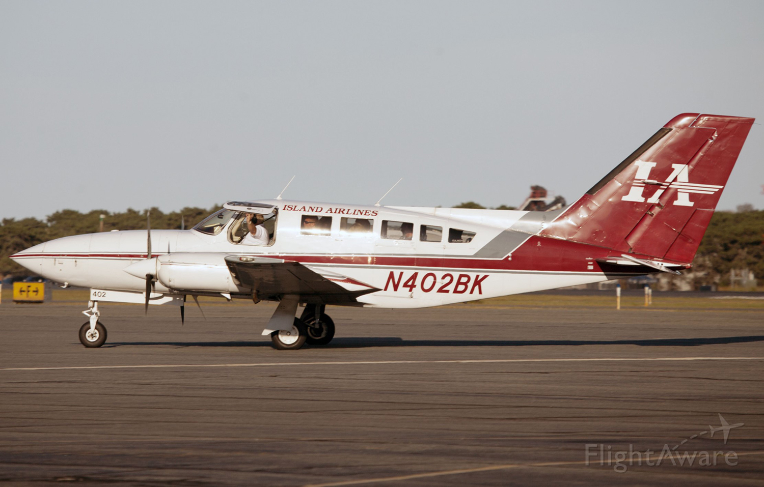
Crash of a Cessna 402C II in Martha's Vineyard

Date & Time: Jan 30, 2001 at 1835 LT
Type of aircraft:
Operator:
Registration:
N6837Y
Flight Type:
Survivors:
Yes
Schedule:
Providence – Martha’s Vineyard
MSN:
402C-0467
YOM:
1981
Flight number:
9K415
Crew on board:
2
Crew fatalities:
Pax on board:
0
Pax fatalities:
Other fatalities:
Total fatalities:
0
Captain / Total flying hours:
1668
Captain / Total hours on type:
348.00
Aircraft flight hours:
19131
Circumstances:
The pilot departed on a scheduled flight conducted under night instrument meteorological conditions. Arriving in the area of the destination airport, the weather was reported as, winds from 220 degrees at 18 knots, gusts to 25 knots; 1/2 statute miles of visibility and haze; vertical visibility of 100 feet. The pilot was vectored and cleared for the ILS 24 approach. As the airplane crossed the glideslope, the pilot observed that the "ride" became increasingly bumpy and turbulent, with a strong wind component from the right. The approach lights came into view as the airplane neared the runway, but soon disappeared due to the low visibility. The pilot executed a missed approach, and as full power was applied, the airplane began to move laterally to the left. During the missed approach, a "thunk" was heard on the left side of the fuselage, and the airplane descended into the trees. The airplane came to rest in a wooded area about 1/4 mile from the Runway 24 threshold, about 1,000 feet to the left of the extended centerline. Review of the approach plate for the ILS 24 approach revealed that the glide slope altitude at the final approach fix for the non-precision approach, which was located about 4 miles from the approach end of the runway, was 1,407 feet. The glide slope altitude at the middle marker, which was located about 0.6 miles from the approach end of the runway, was 299 feet. Review of radar data revealed that the airplane intercepted the glideslope about 4 miles from the threshold of runway 24. In the following 2 minutes, 30 seconds, the airplane deviated below and returned to the glideslope centerline approximately 4 times, with a maximum deviation of 2-dots below the glideslope centerline. About 1-mile from the runway, the airplane began a trend downward from the glideslope centerline, descending below the 2- dot low deviation line of the glideslope to an altitude of about 300 feet, when the last radar hit was recorded. During the approach, the airplane's ground speed varied between 50 and 125 knots. According to the Aeronautical Information Manual chapter on Navigation Aids, Instrument Landing System (ILS), it stated that "Make every effort to remain on the indicated glide path." It also cautioned the pilot to, "Avoid flying below the glide path to assure obstacle/terrain clearance is maintained."
Probable cause:
The pilot's failure to maintain a stabilized approach with an adequate vertical and lateral track. Also causal was his failure to maintain obstacle clearance.
Final Report:

Crash of a Mitsubishi MU-2B-26A Marquise in Martha’s Vineyard: 4 killed

Date & Time: Oct 6, 2000 at 2158 LT
Type of aircraft:
Registration:
N60BT
Flight Type:
Survivors:
No
Schedule:
Trenton – Martha’s Vineyard
MSN:
358
YOM:
1977
Crew on board:
1
Crew fatalities:
Pax on board:
3
Pax fatalities:
Other fatalities:
Total fatalities:
4
Captain / Total flying hours:
1946
Captain / Total hours on type:
253.00
Aircraft flight hours:
5400
Circumstances:
The pilot departed on a night cross-country flight without obtaining a weather briefing or flight plan. Arriving in the area of the destination airport, the weather was reported as, 2 statute miles of visibility and mist; overcast cloud layer at 100 feet. The pilot requested an instrument flight rules clearance from the approach controller, and was vectored and cleared for the ILS 24 approach. The clearance included an altitude restriction of 1,500 feet msl, until the airplane was established on the localizer. As the pilot contacted the control tower, the tower controller issued a low altitude alert to the pilot. The pilot replied that he was climbing and the tower controller cleared the pilot to land, which the pilot acknowledged. No further pertinent radio transmissions were received from the airplane. The airplane came to rest in a wooded area about 3/4-mile from the runway threshold, and about 50 feet right of the extended centerline. Review of the approach plate for the ILS 24 approach revealed that the minimum glide slope intercept altitude at the beginning of the final approach segment on the precision approach was 1,500 feet. The glide slope altitude at the final approach fix for the non-precision approach, which was located about 4 miles from the approach end of the runway, was 1,407 feet. The glide slope altitude at the middle marker, which was located about 0.6 miles from the approach end of the runway, was 299 feet. Review of radar data revealed that the airplane was observed at 700 feet, about 4 miles from the airport, and at 300 feet, about 1.5 miles from the airport. The pilot had accumulated about 1,946 hours of total flight experience, with about 252 hours in make and model. The pilot had attended initial and recurrent training for the make and model airplane; however, did not complete the training. The pilot, aged 61, was Charles B. Yates, member of the New Jersey Senate, who was flying to Martha's Vineyard with his wife and two of his three children.
Probable cause:
The pilot's failure to follow instrument flight procedures resulting in a collision with a tree. A factor related to the accident was the low cloud ceiling.
Final Report:

Crash of a Piper PA-61P Aerostar (Ted Smith 601) in Northampton

Date & Time: Sep 7, 2000 at 0755 LT
Registration:
N601WK
Flight Phase:
Flight Type:
Survivors:
Yes
Schedule:
Northampton – Poughkeepsie
MSN:
61-0792-8063404
YOM:
1980
Crew on board:
1
Crew fatalities:
Pax on board:
1
Pax fatalities:
Other fatalities:
Total fatalities:
0
Captain / Total flying hours:
4280
Captain / Total hours on type:
2641.00
Aircraft flight hours:
3595
Circumstances:
The airport consisted of a single runway oriented on a heading of 140/320 degrees. A taxiway oriented on a 120 degree heading intersected the runway at its midpoint. The pilot reported that the visibility was 500-1,000 feet with fog at the time of departure. Before he took off, the pilot asked his passenger to walk the length of the runway to observe any obstructions, due to the reduced visibility. The pilot then taxied to the run-up pad, set the heading of his HSI to 120 degrees, and initiated the takeoff. When the airspeed reached 80 knots, the pilot realized he had initiated the takeoff on the taxiway instead of the runway. He aborted the takeoff and attempted to maneuver the airplane to the runway. The airplane crossed the runway, impacted a tree, and came to rest upright in a cornfield. The weather reported at the time of the accident at an airport 9 miles away was: wind from 320 degrees at 2 knots; visibility 1/16 mile with fog; sky partially obscured; ceiling 200 feet overcast.
Probable cause:
The pilot's improper preflight planning which resulted in an attempted takeoff from a taxiway. A factor in the accident was the fog.
Final Report:

Crash of a Beechcraft 200 Super King Air in North Adams: 2 killed

Date & Time: Oct 5, 1999 at 0545 LT
Operator:
Registration:
N208MS
Flight Phase:
Flight Type:
Survivors:
No
Schedule:
North Adams - Lewisburg
MSN:
BB-400
YOM:
1978
Crew on board:
2
Crew fatalities:
Pax on board:
0
Pax fatalities:
Other fatalities:
Total fatalities:
2
Captain / Total flying hours:
6450
Captain / Total hours on type:
160.00
Copilot / Total flying hours:
1530
Copilot / Total hours on type:
150
Aircraft flight hours:
6020
Circumstances:
The pre-takeoff instrument flight rules clearance for the flight called for the airplane to climb and maintain 5,000 feet, and to expect flight level 220, 10 minutes after departure. The clearance was read back correctly by a member of the flight crew. Shortly after takeoff, a member of the flight crew asked air traffic control for a higher altitude, and then stated 'uh, you want us at twenty two hundred.' The approach controller transmitted 'should be at five thousand;' however, there were no further transmissions from the airplane. The airplane wreckage was located at an elevation of about 2,300 feet, approximately 4.8 miles west of the departure airport. The airplane impacted wooded up-sloping terrain. Several broken trees were observed, which led to the beginning of the debris path. The trees were broken at about the same height. A weather observation taken at an airport about 12 miles north-northwest of the accident site, about the time of the accident included: few Clouds at 300 feet and a ceiling of 1,700 feet overcast.
Probable cause:
The pilot-in-command's failure comply with an air traffic control clearance which resulted in a collision with terrain. A factor in this accident was clouds.
Final Report:

Crash of a Cessna 414A Chancellor off Mattapoisett: 1 killed

Date & Time: Nov 20, 1998 at 1220 LT
Type of aircraft:
Operator:
Registration:
N6820J
Flight Phase:
Flight Type:
Survivors:
No
Schedule:
Hyannis - New Bedford
MSN:
414A-0671
YOM:
1981
Crew on board:
1
Crew fatalities:
Pax on board:
0
Pax fatalities:
Other fatalities:
Total fatalities:
1
Captain / Total flying hours:
3458
Aircraft flight hours:
2675
Circumstances:
The airplane was level at 2,000 feet, in instrument meteorological conditions, when the pilot reported 'we've just lost our ahh artificial horizon.' About 5 minutes later, air traffic control lost radar contact, and communications with the airplane. A witness about 1 mile north of the accident site stated he heard the sound of engine noise coming from the water and he described the sound as loud and constant. The sound lasted for about 30 seconds and was followed by an 'explosive collision/impact sound.' He further stated he walked to the shore and attempted to locate the source of the sound, but 'because of the fog, I couldn't see anything at all.' The airplane was located in about 25 feet of water, and was scattered over a 150 to 200 foot area. The recovered wreckage consisted of both engines, parts of the airplane's left wing, empennage, fuselage, seats, and interior. The airplane's attitude indicator was not recovered. A faint needle impression was found on the face of the airplane's vertical speed indicator between minus 2,500 and 3,000 feet per minute. Examination of the left and right vacuum pumps did not reveal any malfunctions or failures.
Probable cause:
The pilot's failure to maintain control of the airplane after an undetermined failure of the airplane's attitude indicator. A factor in this accident was fog.
Final Report:

Crash of a Cessna 402C II in Hyannis: 1 killed

Date & Time: Nov 18, 1994 at 2200 LT
Type of aircraft:
Operator:
Registration:
N402BK
Flight Type:
Survivors:
No
Schedule:
Nantucket - Hyannis
MSN:
402C-0223
YOM:
1979
Crew on board:
1
Crew fatalities:
Pax on board:
0
Pax fatalities:
Other fatalities:
Total fatalities:
1
Captain / Total flying hours:
3350
Captain / Total hours on type:
450.00
Aircraft flight hours:
14178
Circumstances:
The airplane was on an ILS runway 15 approach and collided in-flight with static wires, approximately 2 miles north of the runway. The wires were located in the airplane's flight path, and in a direct line with the ILS final approach course. At the time of the accident the local control tower was closed. Three other aircraft made the approach prior to N402BK, and the pilots of those aircraft all agreed that at about 500 to 700 feet msl, on the final approach course, they encountered downdrafts and turbulence. All the pilots agreed, the downdrafts caused their airplanes to fall below the glide slope, and that in order to rejoin the glide slope, they had to increase power or change the airplane's pitch attitude. The Otis Air National Guard Base 2155 weather observation was; indefinite ceiling 100 sky obscured, visibility 3/4 miles, light rain and fog, temperature 59° F, dew point 58° F, wind 170°, 14 knots, gust to 19, altimeter 29.96 inches hg.
Probable cause:
The pilot's failure to maintain a proper glide path during an ILS approach, which resulted in a collision with power lines. Factors in this accident were; adverse weather conditions with turbulence, downdrafts and fog.
Final Report:

Crash of a Beechcraft A100 King Air in North Adams: 1 killed

Date & Time: Aug 4, 1994 at 1605 LT
Type of aircraft:
Registration:
N7GA
Flight Phase:
Flight Type:
Survivors:
No
Schedule:
North Adams – White Plains
MSN:
B-119
YOM:
1972
Crew on board:
1
Crew fatalities:
Pax on board:
0
Pax fatalities:
Other fatalities:
Total fatalities:
1
Captain / Total flying hours:
10200
Captain / Total hours on type:
106.00
Aircraft flight hours:
10426
Circumstances:
The airplane had undergone routine maintenance for slow acceleration on the right engine. Maintenance records revealed the fuel controls were changed from the right engine to the left engine. The airplane was released back to the pilot for service, and he departed for his home station. Several witnesses saw the airplane after takeoff at a low altitude, and at a slow speed. The airplane turned left, and the left wing struck the ground. Two witnesses saw the airplane pass by them at a low altitude, and wrote, '...at this point we could see the left (port) engine propeller was turning very slowly. You could actually see the individual blades of the propeller turning.' A complete disassembly of both engines, revealed no discrepancies other than impact, and post impact fire damage. Disassembly of the left propeller indicated that the propeller blades were at or near feather at impact. The pilot had a total of 106 flight hours in Beech A100 aircraft, all in the 90 days prior to the accident, and 56 hours in the 30 days prior to the accident.
Probable cause:
The pilot's failure to maintain minimum control speed after an undetermined loss of engine power, which resulted in an inadvertent stall at too low of an altitude to allow recovery.
Final Report:

Crash of a Piper PA-31T Cheyenne II in Norwood

Date & Time: Feb 21, 1994 at 1750 LT
Type of aircraft:
Registration:
N777JM
Survivors:
Yes
Schedule:
Bangor - Norwood
MSN:
31-7820064
YOM:
1978
Crew on board:
2
Crew fatalities:
Pax on board:
3
Pax fatalities:
Other fatalities:
Total fatalities:
0
Captain / Total flying hours:
14800
Captain / Total hours on type:
2000.00
Aircraft flight hours:
5466
Circumstances:
The flight crew was advised prior to initiating the approach that visibility at the airport had decreased to 1/8 mile with light rain, fog and obscuration. Published landing visibility minimums for the approach was 1 mile. The 150 feet wide runway had been plowed 100 feet wide, and there were snowbanks up to 3 feet high on both sides. The airplane touched down on the unplowed portion of the runway onto a snowbank, collapsing the landing gear. The flightcrew stated that the approach lights and runway were in sight during the entire approach, and that the second pilot told the pic that he was too far left and needed to correct to the right as the airplane was about to touchdown. The tower controller stated that he lost sight of the airplane as it landed due to fog.
Probable cause:
The pilot's failure to attain alignment with the centerline of the runway, and his failure to execute a missed approach. Factors which contributed to the accident were: the dark night, the pilot's improper decision to initiate the approach in below-minimum weather conditions, the adverse weather, and the snow covered runway.
Final Report:

Crash of a Piper PA-31T Cheyenne II in Mattapan: 3 killed

Date & Time: Aug 24, 1990 at 0633 LT
Type of aircraft:
Registration:
N85HB
Flight Type:
Survivors:
No
Site:
Schedule:
Chatham – Boston
MSN:
31-8120021
YOM:
1981
Crew on board:
1
Crew fatalities:
Pax on board:
2
Pax fatalities:
Other fatalities:
Total fatalities:
3
Captain / Total flying hours:
2926
Captain / Total hours on type:
536.00
Circumstances:
The pilot noted an over torque condition in the left engine as the aircraft was on an ILS approach. He made a go-around and initiated another approach with the engine shut down. He was unable to maintain altitude and the aircraft began a decent that was not arrested. Subsequently, it crashed into 2 homes, approximately 6 miles from the airport. An exam of the left engine revealed the drive shaft from the fuel pump to the fuel control was sheared at the plastic coupling. Further exam revealed the twin bearings that supported the driveshaft had failed. Also, there was evidence the drive shaft had shifted and subsequently an overtorque condition resulted. All three occupants were killed.
Probable cause:
The pilot's improper in-flight planning/decision, which resulted in his failure to maintain control of the aircraft. Factors related to the accident were: failure of the left fuel control unit, and the adverse weather conditions.
Final Report:

Crash of a Beechcraft 60 Duke in Norwood

Date & Time: Oct 26, 1988 at 1200 LT
Type of aircraft:
Registration:
N8PX
Flight Phase:
Flight Type:
Survivors:
Yes
Schedule:
Norwood – West Bow
MSN:
P-436
YOM:
1977
Crew on board:
1
Crew fatalities:
Pax on board:
0
Pax fatalities:
Other fatalities:
Total fatalities:
0
Captain / Total flying hours:
4800
Captain / Total hours on type:
120.00
Aircraft flight hours:
1400
Circumstances:
The pilot had just climbed to 2,500 feet when the right engine started to sputter. When he placed the fuel selector in crossfeed, both engines quit. The pilot elected to land in a field leading to substantial damage to the nose, wings, and tail section of the aircraft. A post crash inspection of fuel system revealed no fuel in the tanks or the fuel metering units for either engine. The pilot stated after the accident that the last time he refueled the aircraft was several weeks before and that it had been flown several times since its last refueling.
Probable cause:
Occurrence #1: loss of engine power (total) - nonmechanical
Phase of operation: climb
Findings
1. All engines
2. (c) fluid, fuel - exhaustion
3. (c) aircraft preflight - inadequate - pilot in command
4. (c) refueling - not performed - pilot in command
----------
Occurrence #2: forced landing
Phase of operation: descent - emergency
----------
Occurrence #3: in flight collision with terrain/water
Phase of operation: landing - flare/touchdown
Findings
5. Object - tree(s)
6. Wheels up landing - performed - pilot in command
Final Report: