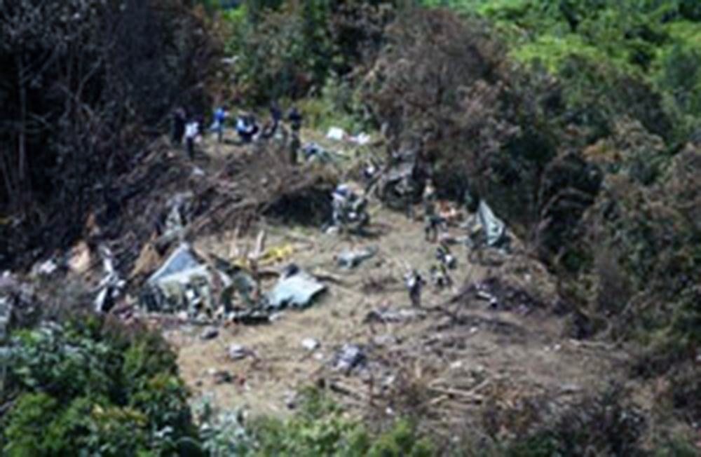
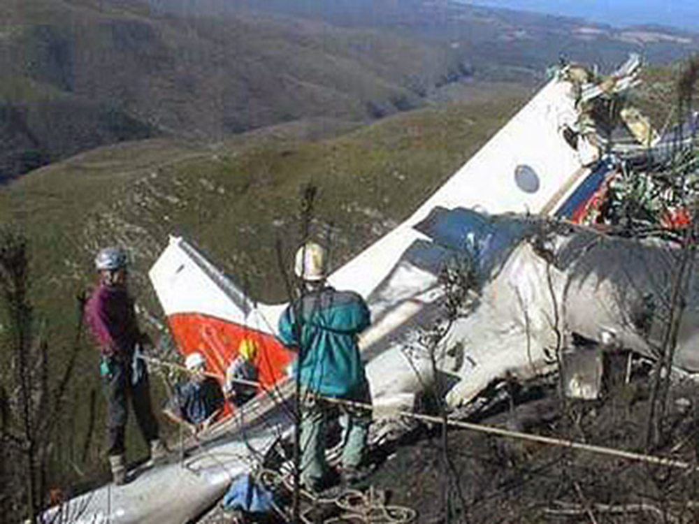
Crash of a Lockheed MC-130H Hercules in Caguas: 10 killed

Date & Time: Aug 7, 2002 at 2050 LT
Type of aircraft:
Operator:
Registration:
90-0161
Flight Type:
Survivors:
No
Site:
Schedule:
Roosevelt Roads - Roosevelt Roads
MSN:
5265
YOM:
1991
Country:
Crew on board:
10
Crew fatalities:
Pax on board:
0
Pax fatalities:
Other fatalities:
Total fatalities:
10
Circumstances:
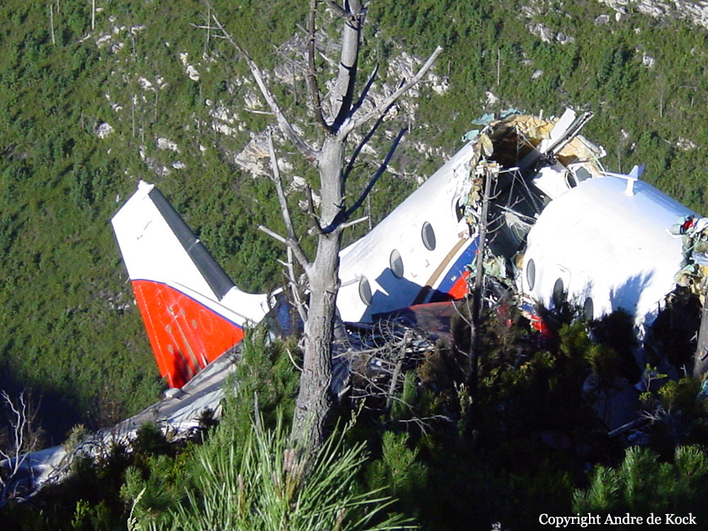
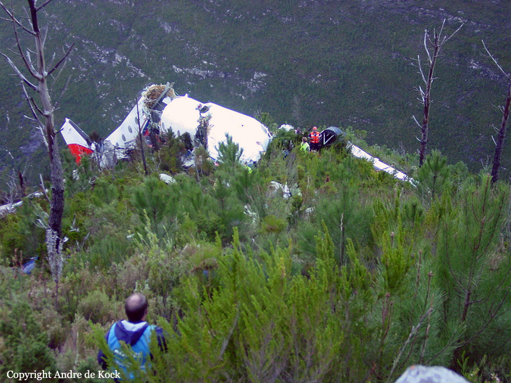
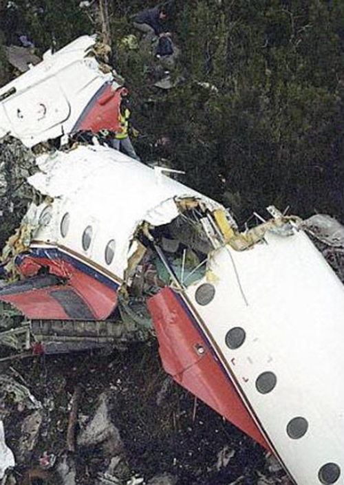
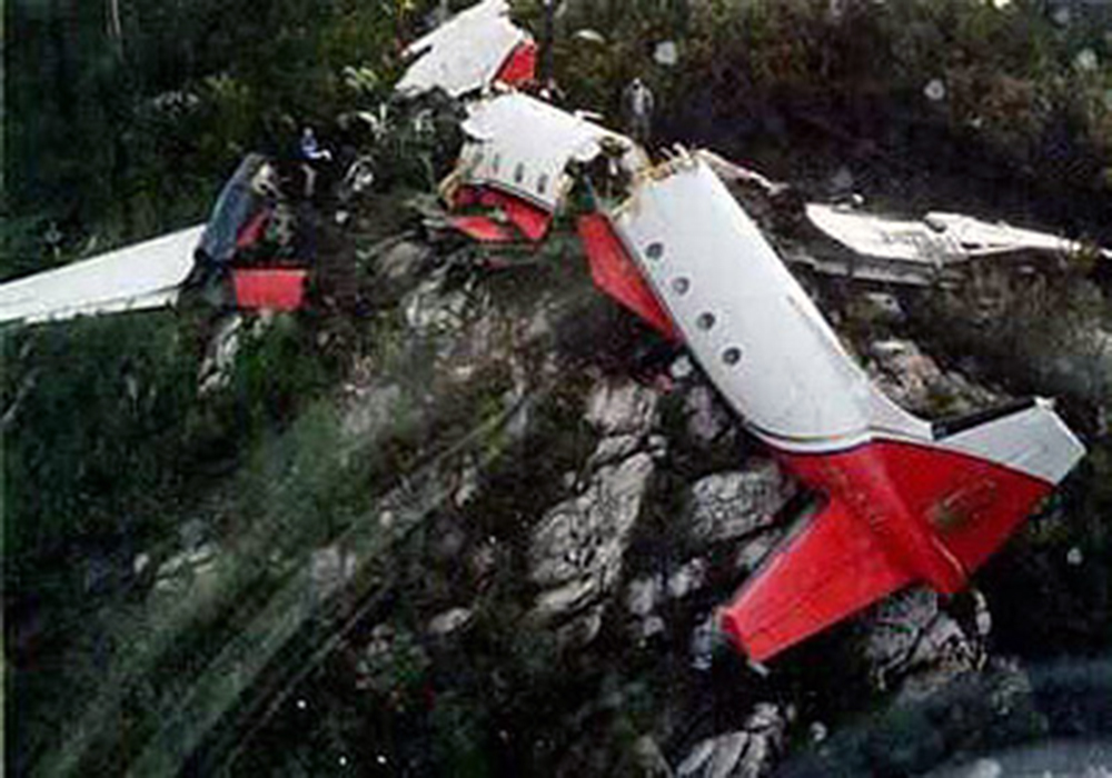
The crew departed Roosevelt Roads NAS on a local training flight. In the evening, while returning the to NAS, the crew encountered poor weather conditions with low clouds, limited visibility and rain falls. While descending at low height, the crew suffered a loss of situational awareness and failed to respond to obstacle warnings. The four engine aircraft collided with trees and crashed on the top of Mt Perucho. The aircraft disintegrated on impact and all 10 crew members were killed.
Probable cause:
By clear and convincing evidence, the cause of this mishap was an uncharacteristic loss of situational awareness by the entire mishap flight deck crew and the subsequent lack of an appropriate response to obstacle warnings. The Board President further found the following factors substantially contributed to the mishap: overall crew preparation, a misdirected focus on the weather, crew resource management dynamics, and crew judgment as it relates to existing directives.

Crash of a Consolidated PB4Y-2 Super Privateer near Estes park: 2 killed

Date & Time: Jul 18, 2002 at 1840 LT
Operator:
Registration:
N7620C
Flight Phase:
Flight Type:
Survivors:
No
Site:
Schedule:
Broomfield - Broomfield
MSN:
66260
YOM:
1944
Flight number:
Tanker 123
Crew on board:
2
Crew fatalities:
Pax on board:
0
Pax fatalities:
Other fatalities:
Total fatalities:
2
Captain / Total flying hours:
3658
Captain / Total hours on type:
1328.00
Copilot / Total flying hours:
6689
Copilot / Total hours on type:
913
Aircraft flight hours:
8346
Circumstances:
The airplane was maneuvering to deliver fire retardant when its left wing separated. Aircraft control was lost and the airplane crashed into mountainous terrain. A witness on the ground took a series of photographs that showed the air tanker's left wing separating at the wing root and the remaining airplane entering a 45-degree dive to the ground in a counterclockwise roll. An examination of the airplane wreckage revealed extensive areas of preexisting fatigue in the left wing's forward spar lower spar cap, the adjacent spar web, and the adjacent area of the lower wing skin. The portion of the wing containing the fatigue crack was obscured by the retardant tanks and would not have been detectable by an exterior visual inspection. An examination of two other air tankers of the same make and model revealed the area where the failure occurred on the accident airplane was in a location masked by the airplane's fuselage construction. The airplane was manufactured in 1945 and was in military service until 1956. It was not designed with the intention of operating as a firefighting airplane. In 1958, the airplane was converted to civilian use as an airtanker and served in that capacity until the time of the accident. The investigation revealed that the owner developed service and inspection procedures for the airtanker; however, the information contained in the procedures did not adequately describe where and how to inspect for critical fatigue cracks. The procedures were based on U.S Navy PB4Y-2 airplane structural repair manuals that had not been revised since 1948.
Probable cause:
The inflight failure of the left wing due to fatigue cracking in the left wing's forward spar and wing skin. A factor contributing to the accident was inadequate maintenance procedures to detect fatigue cracking.
Final Report:

Crash of a De Havilland DHC-6 Twin Otter 300 in Surkhet: 4 killed

Date & Time: Jul 17, 2002 at 1422 LT
Operator:
Registration:
9N-AGF
Survivors:
No
Site:
Schedule:
Jumla - Surkhet
MSN:
828
YOM:
1985
Location:
Country:
Region:
Crew on board:
2
Crew fatalities:
Pax on board:
2
Pax fatalities:
Other fatalities:
Total fatalities:
4
Circumstances:
The twin engine aircraft departed Jumla at 1404LT on a 25-minutes flight to Surkhet with two passengers and two pilots on board. While descending to Surkhet, the crew encountered poor visibility due to bad weather conditions. At an altitude of 6,500 feet, the aircraft struck the slope of a mountain and crashed 10 km from Surkhet. All four occupants were killed.
Probable cause:
Controlled flight into terrain after the crew descended below the minimum prescribed altitude in poor visibility.

Crash of a De Havilland DHC-2 Beaver near Port Alsworth: 4 killed

Date & Time: Jul 12, 2002 at 1145 LT
Type of aircraft:
Operator:
Registration:
N3129F
Flight Phase:
Survivors:
No
Site:
Schedule:
Anchorage - Iliamna
MSN:
903
YOM:
1956
Crew on board:
1
Crew fatalities:
Pax on board:
3
Pax fatalities:
Other fatalities:
Total fatalities:
4
Captain / Total flying hours:
4745
Captain / Total hours on type:
258.00
Aircraft flight hours:
12698
Circumstances:
The commercial pilot of the float-equipped airplane was transporting passengers to a lodge at a remote lake. When the airplane did not arrive at the lake, a search was initiated, and two days later the wreckage of the airplane was located on the side of a box canyon about the 2,400 foot elevation level. The canyon is oriented approximately east-west, and the wreckage was distributed along a 100 foot debris field on the north flank of the canyon. Ground scars and wreckage distribution were consistent with the airplane impacting terrain in a steep left bank while executing a turn to reverse direction. No evidence of any preimpact mechanical anomalies was discovered.
Probable cause:
The pilot's failure to maintain clearance from terrain while maneuvering inside a box/blind canyon, resulting in an in-flight collision with terrain. A factor contributing to the accident was the box/blind canyon.
Final Report:

Crash of a De Havilland DHC-3 Otter near Lake Cojibo

Date & Time: Jun 30, 2002 at 0900 LT
Type of aircraft:
Operator:
Registration:
C-GUTQ
Flight Phase:
Survivors:
Yes
Site:
MSN:
402
YOM:
1960
Country:
Crew on board:
1
Crew fatalities:
Pax on board:
2
Pax fatalities:
Other fatalities:
Total fatalities:
0
Circumstances:
The single engine aircraft departed Lake Cojibo with two passengers, one pilot and a full load of freight, destined for a fishing camp. Weather conditions were good but the OAT was high. After takeoff, the aircraft encountered difficulties to maintain a proper rate of climb due to the high temperature and the weight it was carrying. The pilot entered a valley and while trying to gain height to clear rising terrain, the aircraft struck the top of a mountain and crashed, bursting into flames. All three occupants were injured and the aircraft was destroyed by fire.

Crash of an Avro 748 in George: 3 killed

Date & Time: Jun 1, 2002 at 0715 LT
Type of aircraft:
Operator:
Registration:
ZS-OJU
Flight Type:
Survivors:
No
Site:
Schedule:
Bloemfontein - George
MSN:
1782
YOM:
1980
Country:
Region:
Crew on board:
2
Crew fatalities:
Pax on board:
1
Pax fatalities:
Other fatalities:
Total fatalities:
3
Captain / Total flying hours:
20963
Captain / Total hours on type:
1819.00
Copilot / Total flying hours:
1099
Copilot / Total hours on type:
518
Aircraft flight hours:
14226
Aircraft flight cycles:
19789
Circumstances:
The aircraft was on a scheduled freight flight from Bloemfontein to George. Poor weather conditions prevailed over the George area and the pilots had to execute an instrument guided approach for the landing. The ground based Instrument Landing System (ILS) on Runway 29 at George Aerodrome was intermittently unreliable during the approach. The pilots decided to execute a missed approach. During the missed approach the pilots did not comply with the published missed approach procedure and with a combination of strong winds and possible erroneous heading indications they lost situational awareness. They flew the aircraft into a valley and crashed into the side of the mountains North-East of the George Aerodrome. The passenger was Hansie Cronje, a former South African cricket captain who had missed a South African Airlines flight.
Probable cause:
The crew deviated from the prescribed missed approach procedure during an attempted Instrument Landing System landing on Runway 29 at George in Instrument Meteorological Conditions and lost situational awareness aggravated by the presence of strong upper SouthWesterly winds. They allowed the aircraft to drift off course resulting in a controlled impact with terrain 6.7 nm North-East of the aerodrome. Contributing factors to the probable cause were the weather conditions, the intermittent unreliability of the Instrument Landing System, the serviceability of the directional gyro and the uncleared defects.
Final Report:

Crash of a De Havilland DHC-6 Twin Otter 300 near Nabire: 6 killed

Date & Time: May 25, 2002 at 0700 LT
Operator:
Registration:
PK-YPZ
Flight Phase:
Survivors:
No
Site:
Schedule:
Nabire – Enarotali
MSN:
458
YOM:
1975
Country:
Region:
Crew on board:
4
Crew fatalities:
Pax on board:
2
Pax fatalities:
Other fatalities:
Total fatalities:
6
Circumstances:
While cruising in poor weather conditions at an altitude of 7,800 feet, the twin engine aircraft struck the slope of a mountain located about 50 km from Nabire. The aircraft was destroyed and all six occupants were killed. At the time of the accident, the visibility was poor due to heavy rain falls and the mountain struck by the aircraft was shrouded in mist.
Probable cause:
Controlled flight into terrain.

Crash of a Piper PA-31-310 Navajo near Atlanta: 3 killed

Date & Time: Mar 12, 2002 at 1437 LT
Type of aircraft:
Registration:
N2336V
Flight Phase:
Flight Type:
Survivors:
No
Site:
Schedule:
Idaho Falls - Boise
MSN:
31-135
YOM:
1968
Location:
Crew on board:
1
Crew fatalities:
Pax on board:
2
Pax fatalities:
Other fatalities:
Total fatalities:
3
Captain / Total flying hours:
20647
Captain / Total hours on type:
338.00
Aircraft flight hours:
7940
Circumstances:
The aircraft was cleared direct and to climb to 14,000 feet. During the climb out, the controller inquired several times as to the flights altitude. The pilot's response to the controllers queries were exactly 10,000 feet lower than what the controller was indicating on radar. Eventually the controller instructed the pilot to stop altitude squawk, which he did. During the last communication with the pilot, he reported that he was level at 14,000 feet. During the next approximately 45 minutes, the aircraft was observed proceeding generally in the direction of its destination. When the controller observed the flight track turn approximately 45 degrees to the right and headed generally northwest, he attempted to contact the pilot without a response. The tracking then turned about 90 degrees to the left for a few minutes, then turned 180 degrees to the right. The aircraft dropped from radar coverage shortly thereafter. On site investigation revealed that the aircraft broke-up in flight as the wreckage was scattered generally east-to-west over the mountainous terrain for approximately .3 nautical miles. Further investigation revealed that the right wing separated at the wing root in an upward direction. Separation points indicated features typical of overload. The right side horizontal stabilizer separated upward and aft. The left side horizontal stabilizer remained attached however, it was twisted down and aft. The aft fuselage was twisted to the left. Both engines separated in flight from the wings. Post-crash examinations of the airframe and engines did not reveal evidence of a mechanical failure or malfunction. Both altimeters were too badly damaged to test. Autopsy and toxicology results indicated that the pilot had severe coronary artery disease with greater than 95% narrowing of the left anterior descending coronary artery by atherosclerotic plaque. The coroner also reported that superimposed upon this severe narrowing was complete occlusion of the lumen by brown thrombus. Toxicology results indicated a moderate level of diabetes. The pilot's actions leading up to the accident were consistent with an incapacitation due to hypoxia. The role of a possible heart attack was unclear, since it is possible that it occurred as a result of the hypoxia.
Probable cause:
The pilot's failure to maintain aircraft control while in cruise flight which resulted in the in-flight separation due to overload of the spar at the right wing root. Hypoxia was a factor.
Final Report:

Crash of a PZL-Mielec AN-2TP near Rocca di Mezzo: 3 killed

Date & Time: Mar 9, 2002 at 1339 LT
Type of aircraft:
Registration:
LY-AVD
Flight Phase:
Flight Type:
Survivors:
No
Site:
Schedule:
Budapest - Tunis
MSN:
1G137-53
YOM:
1972
Flight number:
SJK2801
Country:
Region:
Crew on board:
2
Crew fatalities:
Pax on board:
1
Pax fatalities:
Other fatalities:
Total fatalities:
3
Circumstances:
The aircraft departed Budapest-Ferihegy Airport at 0829LT on a VFR flight to Tunis. According to the flight plan the aircraft would fly over Split, Pescara, crossing the Apennines towards Ostia and then onwards to Tunis. Weather conditions over the central part of Italy were poor with a cold front associated with thunderstorm activity, low clouds and icing conditions. After passing over the Adriatic sea, the aircraft overflew Pescara at 1320LT where the pilot informed ATC that the aircraft was inbound Aneda (a reporting point 19 NM East of Monte Rotondo) at a cruising altitude of 5.500 feet. While in vicinity of Pescara, ATC requested and obtained confirmation from the crew that he was able to continue under VFR mode. Shortly later, at a speed of 115 knots, the single engine aircraft struck the slope of Mt Rotondo (1.880 metres high) located near Rocca di Mezzo. The aircraft disintegrated on impact and all three occupants were killed.
Probable cause:
Analysis of available evidence make it reasonable to classify the event investigated as an unintentional terrain impact, Controlled Flight Into Terrain (CFIT). At accident time, because of the reduced visibility, incompatible with VFR flying, the crew could not evaluate correctly the orography of the area along there route. It has to be noted that it was not possible to ascertain if adequate maps were available to the crew showing the exact position of ground relief and obstacles. It was not possible to determine if the pilots had flown across the same area in the past. Given the meteorological conditions over the area, the crew did not conform to the Visual Flying Rules that mandated for a track change to maintain the required flight parameters (visibility/clearance from obstacles) and/or a diversion to a suitable alternate airport (as international rules mandate).
Contributing factors:
Analysis of available evidence suggests that the following may be considered as contributory factors to the accident. The prevailing meteorological conditions existing on March 9, 2002 over the flight path of LY-AVD across the central part of Italy did not allow for the flight to be continued under VFR. The Antonov AN-2 was not fit for flying in low visibility (IMC) and was not equipped for flying in icing conditions. The pilot of the LY-AVD did not hold the required English language radio-telephony (RT) qualification to operate outside the country of licensing. The pilot of the LY-AVD did not hold an IFR qualification (for flying in IMC).
Final Report:

Crash of a Beechcraft 300LW Super King Air on Piz Sarsura: 2 killed

Date & Time: Feb 14, 2002 at 1720 LT
Operator:
Registration:
D-ICBC
Flight Phase:
Survivors:
No
Site:
Schedule:
Poznań – Samedan
MSN:
FA-227
YOM:
1993
Country:
Region:
Crew on board:
1
Crew fatalities:
Pax on board:
1
Pax fatalities:
Other fatalities:
Total fatalities:
2
Captain / Total flying hours:
4158
Captain / Total hours on type:
1835.00
Aircraft flight hours:
4141
Circumstances:
D-ICBC was refuelled in Poznan to its maximum capacity of 2040 litres. An ATC flight plan was filed for an IFR flight. After the RENTA waypoint, VFR had actually been entered, but the crew had not filed the flight plan as a Y flight plan, as is prescribed for flights which begin under IFR rules and then end as a VFR flight. However, the flight plan was entered and transmitted as a Y flight plan by the competent unit in Brussels. Take-off time was scheduled for 14:20 UTC. Take-off actually took place at 14:35 UTC. No details are known about the history of the first part of the flight. The aircraft reached the border with Italian airspace in the planned air corridor M736 at flight level 250. The crew reported at 15:54:14 UTC to Padua ACC, sector LOW NORD on frequency 125.900 MHz: “..ua Buongiorno D-ICBC, Flight level 250, appro…approaching LIZUM Point” The air traffic controller instructed the crew to fly “LIZUM, LUSIL direct”. The crew confirmed “LIZUM .... direct DBC”. On enquiring, they received the information that they would be able to descend in about 10 miles. On the radar plot it can be seen that the aircraft did not fly as required direction LUSIL, but turned onto a heading of approximately 240° and was flying in the direction of Samedan. At 15:59:18 UTC, the clearance to flight level 170 was given; which is the lowest IFR flight level (minimum enroute altitude – MEA) in this area. At 16:02:03 UTC, the crew of D-ICBC was asked whether they were flying direct to Samedan. This was confirmed by them. They were then requested to report as soon as they wished to change from instrument flight rules to visual flight rules. At 16:05:16 UTC, the crew change from instrument flight rules to visual flight rules and were requested to contact Samedan Tower on frequency 135.325 MHz, which they did after a brief delay. The Samedan air traffic controller informed the crew that runway 21 was in use and that the QNH was 1012 hPa. He additionally requested them to report as soon as they flew into the valley. After leaving flight level 170, the aircraft turned slightly to the right onto a course of approximately 265° and maintained its continuous descent. At 16:11:25 UTC, the aircraft passed flight level 130 and began to turn slowly to the left. This turn brought the aircraft precisely onto the extended centre line of runway 21 in Samedan. The aircraft was last captured by the radar at 16:15:24. The last flight level indicated on the secondary radar was FL 101. A little later, the aircraft collided with the elevated terrain of the Sarsura glacier at an elevation of 9640 ft AMSL. Both pilots were killed immediately. The aircraft was destroyed.
Probable cause:
The accident is caused by the fact that the crew on its approach according to visual flight rules to Samedan aerodrome, under critical weather conditions and applying inappropriate flying tactics lost the situational awareness and theby the aircraft D-ICBC collided with the terrain.
The following findings were identified:
- The pilot was in possession of a senior commercial pilots licence, issued by the Polish authorities.
- There are no indications of any health problems affecting the pilot during the flight involved in the accident.
- The aircraft was admitted for traffic.
- The investigation produced no indications of any pre-existing technical faults which might have caused the accident.
- The mass and centre of gravity at the time of the accident were within the prescribed limits.
- As weather information, only METAR and TAF for Innsbruck, Zurich, Milan Malpensa and Milan Linate were found.
- No documentation for visual approaches to Samedan were found in the aircraft.
- In the documentation which was available to the investigators, it was not evident that any of the crew members had previously flown to Samedan.
Final Report: