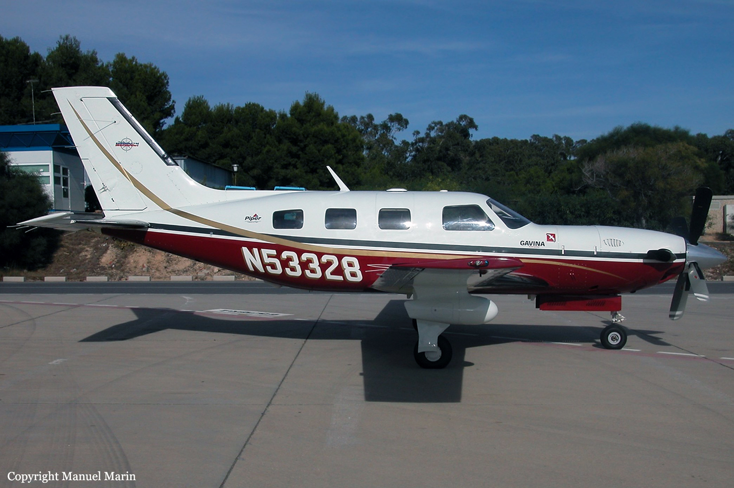
Crash of a Piper PA-46-500TP Malibu Meridian in Bunyola: 3 killed

Date & Time: Dec 19, 2002 at 1153 LT
Operator:
Registration:
N53328
Flight Phase:
Survivors:
No
Site:
Schedule:
Palma de Mallorca - Sabadell
MSN:
46-97098
YOM:
2001
Flight number:
GVN051
Country:
Region:
Crew on board:
1
Crew fatalities:
Pax on board:
2
Pax fatalities:
Other fatalities:
Total fatalities:
3
Captain / Total flying hours:
460
Captain / Total hours on type:
106.00
Aircraft flight hours:
140
Circumstances:
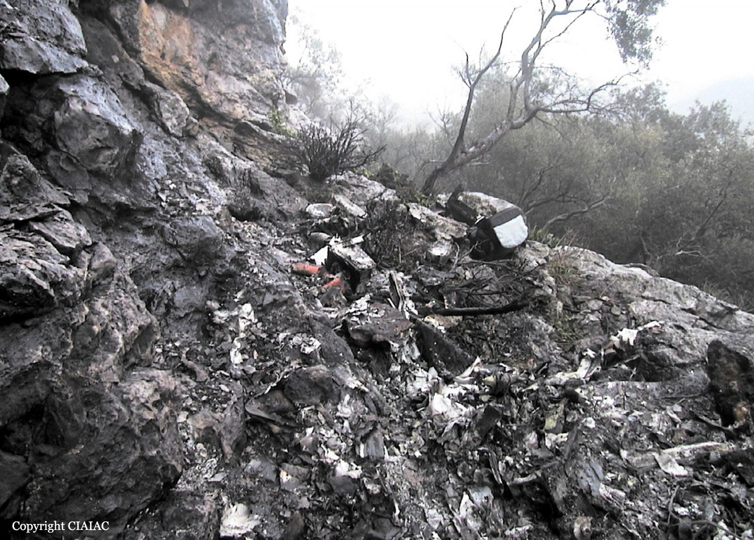
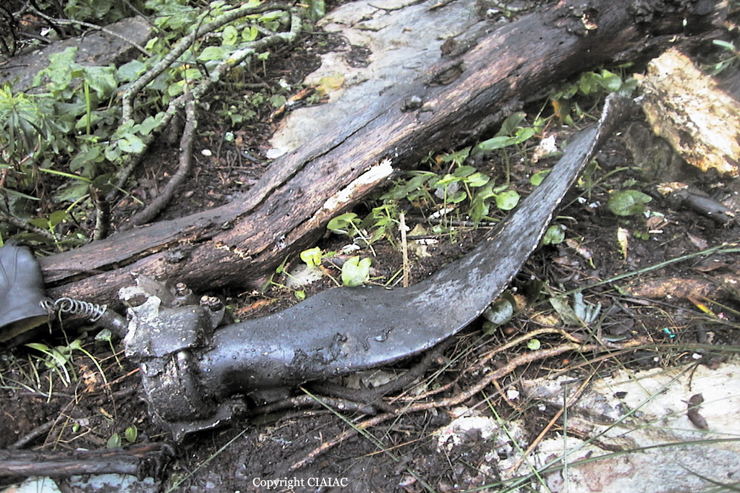
The single engine airplane departed Palma de Mallorca-Son Bonet Airport at 1146LT on a flight to Sabadell with two passengers and one pilot on board. After takeoff, the pilot was instructed by ATC to proceed to the north. Seven minutes after its departure, while flying in reduced visibility due to rain falls, the aircraft struck a rocky wall located on Mt Mola de Montserra (600 metres high) located near the village of Bunyola, about 20 km north of the airport. The aircraft disintegrated on impact and all three occupants were killed. At the time of the accident, the ceiling was at 5,000 feet with a visibility of 8 km and rain. The mountain was shrouded in cloud and thick fog.
Probable cause:
It is believed that the accident occurred as a result of the marginal VMC conditions which existed in the area where the aircraft was flying under VFR rules. The aircraft entered this area possibly due to the pilot’s disorientation and inadequate preparation and execution of the flight.
Final Report:

Crash of a Britten-Norman BN-2A-26 Islander in Tep Tep: 8 killed

Date & Time: Dec 13, 2002
Type of aircraft:
Operator:
Registration:
P2-CBB
Flight Phase:
Survivors:
No
Site:
Schedule:
Tep Tep – Madang
MSN:
140
YOM:
1969
Location:
Region:
Crew on board:
1
Crew fatalities:
Pax on board:
7
Pax fatalities:
Other fatalities:
Total fatalities:
8
Circumstances:
After takeoff from Tep Tep Airstrip, the twin engine aircraft collided with a cliff located in the Finisterre Mountain Range. The aircraft was destroyed and all eight occupants were killed. This was the inaugural flight from the newly constructed Tep Tep Airstrip.

Crash of a Beechcraft 1900C in Eagleton: 3 killed

Date & Time: Dec 9, 2002 at 1140 LT
Type of aircraft:
Operator:
Registration:
N127YV
Flight Phase:
Flight Type:
Survivors:
No
Site:
Schedule:
Wichita - Mena
MSN:
UC-127
YOM:
1990
Crew on board:
2
Crew fatalities:
Pax on board:
1
Pax fatalities:
Other fatalities:
Total fatalities:
3
Captain / Total flying hours:
10200
Aircraft flight hours:
12473
Circumstances:
The aircraft collided with mountainous terrain in a level descent during a visual approach to the destination airport. According to recorded radar data, 10 minutes after descending from 15,000 feet, the flight impacted about 200 feet below the top of the partially obscured ridgeline (elevation of 2550 feet), and 8 miles from the destination. The data indicates the flight path was similar to the global positioning satellite (GPS) approach to the airport. Six minutes before the accident, and the pilot's last transmission to air traffic control, he was informed and acknowledged that radar service was terminated. The flight was 12.4 miles from the accident site when radar contact was lost. Reduced visibility due to fog hampered search & rescue efforts, and the aircraft wreckage was located the next day. The aircraft was equipped with a GPS navigation system; however the installation was incomplete, restricting its use to visual flight rules (VFR) only. The investigation did not determine if the GPS was being used at the time. A non-enhanced Ground Proximity Warning System was also installed. The maximum elevation figure listed on the sectional aeronautical chart covering the area of the accident site and destination airport was 3000 feet mean sea level. The chart also shows an advisory for the area to use caution due to rapidly rising.
Probable cause:
In-flight collision with terrain due to the pilot's failure to maintain clearance and altitude above rapidly rising terrain while on a VFR approach. Contributing factors were the obscuration of the terrain due to clouds.
Final Report:

Crash of a Cessna 421C Golden Eagle III near Tajique: 1 killed

Date & Time: Dec 3, 2002 at 2035 LT
Registration:
N3855C
Flight Phase:
Flight Type:
Survivors:
No
Site:
Schedule:
Alamogordo – Albuquerque
MSN:
421C-0121
YOM:
1976
Crew on board:
1
Crew fatalities:
Pax on board:
0
Pax fatalities:
Other fatalities:
Total fatalities:
1
Captain / Total flying hours:
2500
Aircraft flight hours:
8539
Circumstances:
Prior to departing on the first leg of the flight, the dispatcher advised the pilot that he needed him to check the weather. After advising the pilot that he would be flying an additional leg, the
dispatcher again advised the pilot that he needed him to check the weather, which the pilot did, as observed by the dispatcher. After reaching 14,500 feet at 2028 the pilot contacted Albuquerque Approach Control, advising the controller that he had information "Yankee" and was requesting a lower altitude. The controller instructed the pilot to proceed via his own navigation and to descend at pilot's discretion. The pilot replied "Roger." From 2034 to 2041 the controller made four attempts to contact the pilot, each without success. At 2039 and 2042 the controller asked two other aircraft in the area to try establishing radio communication with the pilot; neither were successful. At 2033:19 the last radar return with altitude information was received from the aircraft, with a reported altitude of 10,200 feet MSL. A primary radar contact, with no transponder or altitude information, was received at 2033:32, 2.2 nautical miles southeast of the accident site, putting it on a straight line between the last radar contact and destination airport. The accident site was located at the 9,012 foot level of a mountain range, 19 nautical miles southeast of the destination airport. Post-accident examination revealed no anomalies with the airframe or engines which would have prevented normal operations. At 1956, the weather observation facility located at the destination airport reported a few clouds at 800 feet, scattered clouds at 2,500 feet, and overcast clouds at 4,200 feet. The remarks section stated rain ended at 35 minutes past the hour, and mountains obscured northeast to southeast. At 2024, the same weather facility reported scattered clouds at 600 feet and overcast clouds at 4,200 feet.
Probable cause:
The pilot's failure to maintain terrain clearance. Factors contributing to the accident were the high mountains, mountain obscuration, the dark night condition, and the pilot's improper inflight planning/decision making.
Final Report:

Crash of a Cessna 207 Skywagon in Marshall

Date & Time: Oct 28, 2002 at 2000 LT
Operator:
Registration:
N91090
Flight Phase:
Flight Type:
Survivors:
Yes
Site:
Schedule:
Marshall - Bethel
MSN:
207-0069
YOM:
1969
Location:
Crew on board:
1
Crew fatalities:
Pax on board:
0
Pax fatalities:
Other fatalities:
Total fatalities:
0
Captain / Total flying hours:
1745
Captain / Total hours on type:
115.00
Aircraft flight hours:
14551
Circumstances:
The commercial pilot was positioning the airplane from the departure airport to another airport. The flight took place on a dark night with overcast skies, and no discernible horizon. The pilot departed and climbed to a cruise altitude between 1,200 and 1,400 feet msl. About 4 miles south of the departure airport, the airplane collided with an east-west ridge at 1,200 feet msl. The ridgeline is perpendicular to the direct route of flight between the departure and destination airports, and rises from west to east with a summit elevation of 1,714 feet msl. The departure airport was a newly commissioned airport 3 miles east-northeast of the old airport. The accident flight was the pilot's second trip to the new airport, and his first night departure from either the old or new airport. Direct flight from the new airport to the destination airport requires a higher altitude to clear the ridgeline than does a direct flight from the old airport. A direct flight from the old airport crosses the same ridgeline farther to the west, where the elevation of the ridge is less than 500 feet msl.
Probable cause:
The pilot's failure to maintain clearance from terrain, which resulted in an in-flight collision with a ridgeline. Factors contributing to the accident were the high terrain, the pilot's inadequate preflight planning, and the dark night light conditions.
Final Report:

Crash of a PZL-Mielec AN-2 near Bodaibo

Date & Time: Sep 30, 2002
Type of aircraft:
Registration:
RA-62587
Flight Phase:
Survivors:
Yes
Site:
Schedule:
Bodaibo – Svetly – Perevoz – Valyukhta
MSN:
1G176-56
YOM:
1977
Country:
Region:
Crew on board:
3
Crew fatalities:
Pax on board:
2
Pax fatalities:
Other fatalities:
Total fatalities:
0
Circumstances:
The single engine airplane departed Bodaibo under VFR mode on a charter flight to Valyukhta with intermediate stops in Svetly and Perevoz. En route, weather conditions deteriorated with low clouds. At an altitude of 1,520 metres, the aircraft struck the slope of a mountain and crashed, bursting into flames. All five occupants escaped with minor injuries while the aircraft was destroyed by fire. The wreckage was found 68 km northeast of Bodaibo.
Probable cause:
Controlled flight into terrain after the crew decided to continue under VFR mode in IMC conditions. Poor operation planning by the operator and poor visibility due to the presence of cumulonimbus were considered as contributing factors.

Crash of a De Havilland DHC-3 Otter near Aguanish River: 3 killed

Date & Time: Sep 28, 2002 at 1135 LT
Type of aircraft:
Registration:
C-FLGA
Survivors:
Yes
Site:
Schedule:
Lake de l'Avion - Aguanish River
MSN:
279
YOM:
1958
Country:
Crew on board:
1
Crew fatalities:
Pax on board:
3
Pax fatalities:
Other fatalities:
Total fatalities:
3
Captain / Total flying hours:
7980
Captain / Total hours on type:
7800.00
Circumstances:
A de Havilland DHC-3 Otter owned by Deraps Aviation Inc., registration C-FLGA, serial number 279, took off from Lake de l'Avion, Quebec, near Natashquan Airport at approximately 1050 eastern daylight time on a flight to a hunting camp 57 miles to the north along the Aguanish River. The pilot and three passengers were on board. Upon arriving at the destination at approximately 1135, the aircraft flew over part of the neighbouring forest before crashing upside down on rugged ground. The passengers were fatally injured on impact. The pilot survived and was evacuated to Sept-Îles by Canadian Forces Search and Rescue services at approximately 0400 on 29 September 2002.
Probable cause:
Because of the geographic and weather conditions, the pilot probably had trouble judging his horizontal and vertical distance with respect to the mountain, and the aircraft crashed.
Final Report:

Crash of a Cessna 650 Citation VI near Xichang: 3 killed

Date & Time: Sep 2, 2002 at 1050 LT
Type of aircraft:
Operator:
Registration:
B-7023
Flight Phase:
Flight Type:
Survivors:
No
Site:
Schedule:
Xichang - Xichang
MSN:
650-0221
YOM:
1992
Location:
Country:
Region:
Crew on board:
3
Crew fatalities:
Pax on board:
0
Pax fatalities:
Other fatalities:
Total fatalities:
3
Circumstances:
The aircraft was dispatched at Xichang Airport to proceed to the calibration of the ILS system. Following a calibration of the runway 36 ILS, the crew initiated a go-around procedure and climbed to 8,000 feet. While completing a 180 turn to join the runway 36 approach pattern, the aircraft impacted a mountain (2,628 metres high) shrouded in clouds and located 15 km southwest of the airport. The aircraft was destroyed and all three crew members were killed. At the time of the accident, the aircraft was cruising at an altitude of 8,400 feet while the minimum altitude for this area is 9,000 feet.
Probable cause:
Controlled flight into terrain.

Crash of a De Havilland DHC-6 Twin Otter 300 in Pokhara: 18 killed

Date & Time: Aug 22, 2002 at 1005 LT
Operator:
Registration:
9N-AFR
Survivors:
No
Site:
Schedule:
Jomsom - Pokhara
MSN:
762
YOM:
1981
Location:
Country:
Region:
Crew on board:
2
Crew fatalities:
Pax on board:
16
Pax fatalities:
Other fatalities:
Total fatalities:
18
Circumstances:
The twin engine aircraft departed Jomsom Airport at 0941LT for a 25-minutes flight to Pokhara, carrying three crew members and 15 passengers, 13 Germans, one American and one British. While descending to Pokhara Airport, the crew encountered poor weather conditions with low clouds. At an altitude of 4,600 feet, the aircraft struck the slope of a mountain located 6 km southwest of the airport, near the village of Kristi Nachnechaur. The aircraft was totally destroyed by impact forces and all 18 occupants were killed. There was no fire.
Probable cause:
Controlled flight into terrain after the crew descended too low in poor visibility without maintaining visual clearance with the ground.

Crash of a Piper PA-31-350 Navajo Chieftain in Sanderson: 1 killed

Date & Time: Aug 16, 2002 at 1135 LT
Registration:
N680HP
Flight Type:
Survivors:
No
Site:
Schedule:
Charleston - Charleston
MSN:
31-8052205
YOM:
1980
Crew on board:
1
Crew fatalities:
Pax on board:
0
Pax fatalities:
Other fatalities:
Total fatalities:
1
Captain / Total flying hours:
5720
Aircraft flight hours:
4493
Circumstances:
The pilot completed a flight without incident, and seemed in good spirits before departing, by himself, on the return flight. The second flight also progressed without a incident until cleared from 8,000 feet msl to 5,000 feet msl, which the pilot acknowledged. Visual meteorological conditions prevailed at the time, and radar data depicted the airplane initiate and maintain a 500-foot per-minute descent until radar contact was lost at approximately 400 feet agl. The pilot made no mention of difficulties while en route or during the descent. The airplane impacted trees at the top of a ridge in an approximate level attitude, and came to rest approximately 1,450 feet beyond, at the bottom of a ravine. Examination of the wreckage revealed no preimpact failures or malfunctions. The pilot had been diagnosed with Crohn's disease (a chronic recurrent gastrointestinal disease, with no clear surgical cure) for approximately 35 years, which required him to undergo several surgeries more than 20 years before the accident. The pilot received a letter from the FAA on June 11, 1998, stating he was eligible for a first-class medical certificate. In the letter there was no requirement for a follow up gastroenterological review, but the pilot was reminded he was prohibited from operating an aircraft if new symptoms or adverse changes occurred, or anytime medication was required. His condition seemed to be stable until approximately 5 months prior to the accident. During this time frame, he experienced weight loss and blood loss, was prescribed several different medications to include intravenous meperidine, received 3 units of blood, and had a peripherally inserted central catheter placed. On the pilot's airmen medical application dated the month prior to the accident, the pilot reported he did not currently use any medications, and did not note any changes to his health. A toxicological test conducted after the accident identified meperidine in the pilot's tissue.
Probable cause:
Physiological impairment or incapacitation likely related to the pilot's recent exacerbation of Crohn's disease. A factor in the accident was the pilot's decision to conduct the flight in his current medical condition.
Final Report: