Crash of a Learjet 24B in Helendale: 2 killed

Date & Time: Dec 23, 2003 at 0913 LT
Type of aircraft:
Operator:
Registration:
N600XJ
Flight Phase:
Survivors:
No
Site:
Schedule:
Chino – Hailey
MSN:
24-190
YOM:
1969
Crew on board:
2
Crew fatalities:
Pax on board:
0
Pax fatalities:
Other fatalities:
Total fatalities:
2
Captain / Total flying hours:
11783
Captain / Total hours on type:
7900.00
Copilot / Total flying hours:
250
Copilot / Total hours on type:
24
Aircraft flight hours:
9438
Circumstances:
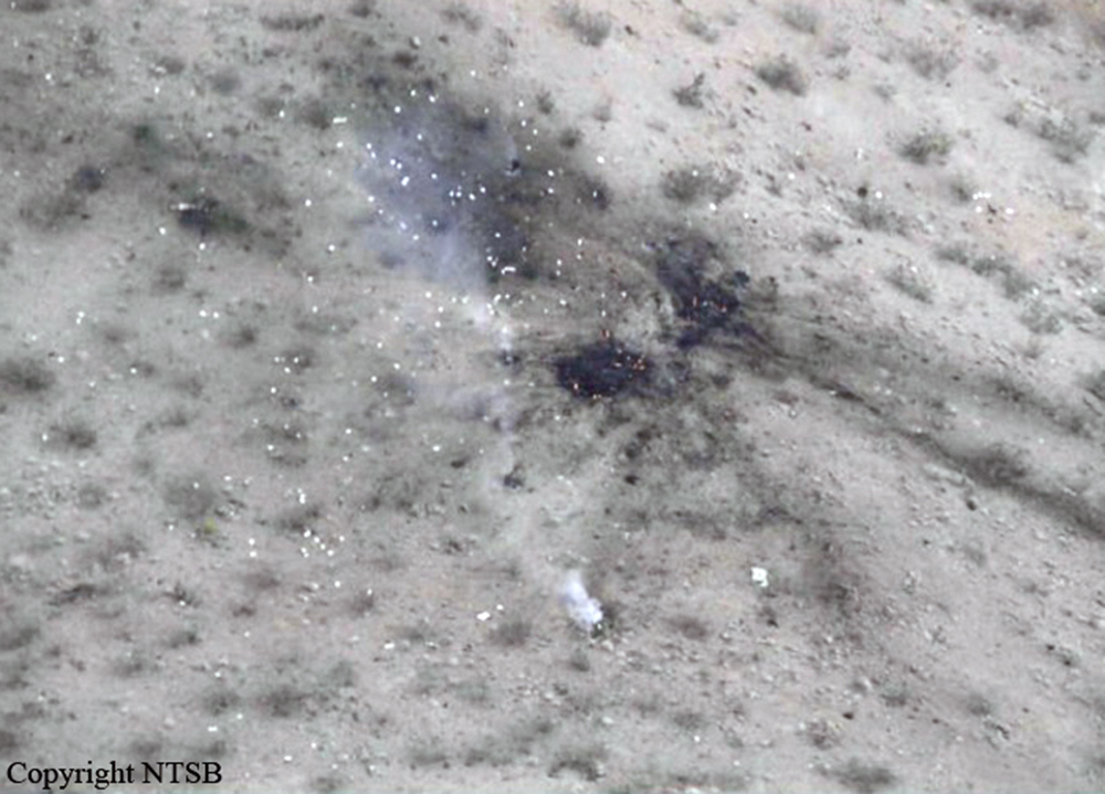
The aircraft departed controlled flight and crashed near Helendale, California. The captain and the first officer were killed, and the airplane was destroyed. The flight was operating under the provisions of 14 Code of Federal Regulations (CFR) Part 912 from San Bernardino County Airport (CNO), Chino, California, to Friedman Memorial Airport, Hailey, Idaho. Visual meteorological conditions prevailed for the flight, which operated on an instrument flight rules flight plan. A review of radar data and air traffic control (ATC) transcripts revealed that the flight departed CNO about 0858 and was cleared to climb to an altitude of 29,000 feet mean sea level (msl). About 0909:55, as the airplane was climbing through an altitude of 26,000 feet, the first officer requested a return to CNO. About 0910:01, the controller asked the first officer if he needed to declare an emergency, and the first officer replied that he did not. The controller then directed the flight crew to maintain an altitude of 24,000 feet. Mode C information for the flight showed that, from about 0910:12 to about 0910:59, the airplane descended from 26,500 to 24,000 feet at a rate of about 2,000 feet per minute (fpm). About 0911:08, the controller cleared the flight directly to HECTOR (a navigation fix) and asked the first officer to confirm that the airplane was in level flight at an altitude of 24,000 feet. The first officer did not respond. Radar data showed the airplane descending through 23,000 feet at a rate of about 6,500 fpm about that time. About 0911:24, while the airplane was descending at a rate of about 10,000 fpm, the first officer stated, “we’re declaring an emergency now.” No further transmissions were received from the airplane. No radar data were available after about 0911:35. Starting about 0911:47, mode C information was invalid. The airplane impacted high desert terrain (an elevation of 3,350 feet) about 3 miles southeast of Helendale. The accident site was located about 46 nautical miles (nm) north of CNO. A witness to the accident, who was located about 4.5 miles northwest of the accident site, stated that, after hearing the sound of a jet flying high overhead, he looked up and observed the accident airplane flying straight and level below a high, overcast cloud layer. He stated that the airplane then pitched “nose down a little” and “straightened again.” He also stated that, shortly thereafter, he observed the airplane’s nose pitch “straight down” until it impacted terrain. The witness reported that he did not notice whether the airplane was rotating about its longitudinal axis during the descent, but he did indicate that the airplane appeared to be intact without any components separating from the airplane during the descent. The witness added that he did not observe any smoke or fire before the airplane impacted terrain and that the airplane exploded into a “mushroom cloud” when it impacted terrain. San Bernardino County firefighters, who were performing controlled burns near the accident site, reported hearing an explosion about the time of the accident. The firefighters reported that they looked toward the direction of the explosion and saw a rising smoke cloud. None of the firefighters observed the airplane before the sound of the explosion. The firefighters drove to the accident site and were the first to arrive there. The firefighters extinguished small fires that had erupted as a result of the crash.
Probable cause:
A loss of airplane control for undetermined reasons.
Final Report:

Crash of a Douglas DC-9-15F near Mitú: 3 killed

Date & Time: Dec 18, 2003 at 1710 LT
Type of aircraft:
Operator:
Registration:
HK-4246X
Flight Phase:
Flight Type:
Survivors:
No
Site:
Schedule:
Yopal – Mitú
MSN:
47062
YOM:
1968
Country:
Crew on board:
3
Crew fatalities:
Pax on board:
0
Pax fatalities:
Other fatalities:
Total fatalities:
3
Captain / Total flying hours:
13768
Captain / Total hours on type:
8054.00
Copilot / Total flying hours:
2300
Copilot / Total hours on type:
601
Aircraft flight hours:
56703
Circumstances:
While cruising at an altitude of 25,000 feet on a cargo flight from Yopal to Mitú, the crew was cleared to descend to 7,000 feet for an approach to runway 01 at Mitú-Fabio Alberto León Bentley Airport. Few minutes later, while descending at an altitude of 23,300 feet, the aircraft entered an uncontrolled descent and crashed in a mountainous and isolated area located about 135 km northwest of Mitú Airport. The wreckage was found 10 days later, on December 28, at coordinates N 002° 19' 15'' W 070° 47' 13''. The aircraft was totally destroyed and all three crew members were killed.
Probable cause:
At the time of the accident, weather conditions were good, the crew was fit for flying and the flight conditions were considered as normal. It was determined that the crew noted two consecutives loud 'bang' before control was lost, and it is believed that the aircraft suffered a structural failure of undetermined origin at the altitude of 23,300 feet.
Final Report:

Crash of a Casa-Nurtanio CN-235M-200 on Pic du Pioulou: 7 killed

Date & Time: Dec 17, 2003 at 1035 LT
Operator:
Registration:
F-RAIA
Flight Phase:
Survivors:
No
Site:
Schedule:
Toulouse - Toulouse
MSN:
C-043
YOM:
1990
Flight number:
COTAM 1492
Country:
Region:
Crew on board:
4
Crew fatalities:
Pax on board:
3
Pax fatalities:
Other fatalities:
Total fatalities:
7
Captain / Total flying hours:
3053
Captain / Total hours on type:
2683.00
Copilot / Total flying hours:
1319
Copilot / Total hours on type:
924
Aircraft flight hours:
4925
Circumstances:
Based at Creil AFB (BA110), the aircraft was dispatched at Toulouse-Francazal AFB on December 15 for a period of three days to conduct local missions with paratroopers. Undel callsign Cotam 1492, the aircraft departed Toulouse-Francazal Airport at 0952LT with 12 paratroopers and four crew members on board on behalf of the Escadron de Transport 01.062 Vercors. At 1017LT, while approaching the drop zone of Tour du Crieu at an altitude of 12,000 feet, nine skydivers left the cabin. Then the captain informed ground he want to conduct a low flight over the Pyrenees mountains for a period of 10-15 minutes before returning to the base. At 1025LT, the aircraft entered the Ariege valley between Foix and Tarascon then the Vicdessos valley. Approaching Suc-et-Sentenac at 1034LT, the aircraft turn to the right and started to climb to pass over the Pic du Pioulou. The climb was started at an altitude of 3,700 feet (600 feet above ground) with a rate of climb of 3,000 feet per minute and a speed of 170 knots. Due pass the Pic du Pioulou (7,200 feet high), the aircraft should climb at least 3,500 feet on a distance of 4,500 metres with an average slope of 23,4% which is over the aircraft capabilities. While climbing with a speed of 100 knots, the stick shaker activated and the stall warning sounded. The speed continued to drop and the aircraft nosed up, reaching an angle of attack of 55°. At a speed of 55 knots, the aircraft stalled, rolled to the left and crashed on the slope of the Pic du Pioulou at an altitude of 1,830 metres. The aircraft was destroyed by impact forces and all seven occupants (four crew members and three paratroopers) were killed.
Crew:
Cpt Charles Edouard Bardinet,
Asp Mallory Bernard,
Adj David Roux,
Adj/C Serge Kaczala,
Cap/C Mickael Larivière,
Cap/C Jérôme Garcia,
Cpt Aude Tessier.
Probable cause:
The accident, which occurred in a delicate aeronautical environment (mountain flying) sees its causes primarily related to the human factor. It occurred during the execution of an unscheduled and unprepared flight phase, by decision of the captain during the flight. Meanwhile, several factors point to an improvable rigor in actions performed by some crew members of this unit. A decision to change the mission in flight combines several errors that led to the accident:
- Overconfidence of the crew, unaccustomed to mountain flying, which engaged in a topography of which they underestimated the difficulty, the insidiously, because gradually, increasing slope,
- A lack of decision in the cockpit that originated in the establishment of a "soft consensus" itself resulting from functions, qualifications and personalities of various crew members,
- Incorrect assessment of the situation and the capabilities of the aircraft with regards to the topography,
- A lack of reaction in a degraded situation.
Final Report:

Crash of a De Havilland DHC-2 Beaver in Viekoda Bay

Date & Time: Nov 29, 2003 at 0935 LT
Type of aircraft:
Operator:
Registration:
N13VF
Survivors:
Yes
Site:
Schedule:
Kodiak – Viekoda Bay
MSN:
1613
YOM:
1965
Crew on board:
1
Crew fatalities:
Pax on board:
2
Pax fatalities:
Other fatalities:
Total fatalities:
0
Captain / Total flying hours:
7103
Captain / Total hours on type:
3100.00
Aircraft flight hours:
14953
Circumstances:
During an on-demand air taxi flight, the airline transport certificated pilot was preparing to land an amphibious float-equipped airplane near a cabin that was located on the shore of a coastal bay. A 10 to 15 knot wind was blowing from the bay toward the land, and the pilot decided to approach over land. As the airplane descended over a small creek bed, adjacent to a hill, the airplane encountered a downdraft, and descended rapidly. The left wing collided with alder trees which spun the airplane 180 degrees. The right wing and float assembly were torn off the airplane. The closest official weather observation station, located 30 miles away, was reporting calm wind.
Probable cause:
The pilot's inadequate evaluation of the weather conditions, and his failure to maintain adequate altitude/clearance, which resulted in a collision with terrain during the final landing approach. A factor contributing to the accident was the presence of a downdraft.
Final Report:

Crash of a Beechcraft C-12C Huron near Charallave: 2 killed

Date & Time: Oct 10, 2003
Type of aircraft:
Registration:
N48JA
Flight Phase:
Flight Type:
Survivors:
No
Site:
Schedule:
Caracas – Charallave
MSN:
BC-51
YOM:
1978
Country:
Crew on board:
2
Crew fatalities:
Pax on board:
0
Pax fatalities:
Other fatalities:
Total fatalities:
2
Circumstances:
Lost without trace on a delivery flight from Caracas to Charallave. The wreckage was not found. Both occupants are presumed dead.

Crash of a Lockheed P2V-7 Neptune near San Bernardino: 2 killed

Date & Time: Oct 3, 2003 at 1116 LT
Type of aircraft:
Operator:
Registration:
N299MA
Flight Type:
Survivors:
No
Site:
Schedule:
Prescott – San Bernardino
MSN:
726-7211
YOM:
1958
Flight number:
Tanker 99
Crew on board:
2
Crew fatalities:
Pax on board:
0
Pax fatalities:
Other fatalities:
Total fatalities:
2
Captain / Total flying hours:
7803
Captain / Total hours on type:
1853.00
Copilot / Total flying hours:
7363
Copilot / Total hours on type:
853
Circumstances:
The fire tanker airplane was on a cross-country positioning flight and collided with mountainous terrain while maneuvering in a canyon near the destination airport. Witnesses who held pilot certificates were on a mountain top at 7,900 feet and saw a cloud layer as far to the south as they could see. They used visual cues to estimate that the cloud tops were around 5,000 feet mean sea level (msl). They noted that the clouds did not extend all the way up into the mountain canyons; the clouds broke up near the head of some canyons. When they first saw the airplane, they assumed that it came from above the clouds. It was proceeding north up a canyon near the edge of clouds, which were breaking up. They were definitely looking down at the airplane the whole time. They saw the airplane make a 180-degree turn that was steeper than a standard rate turn. The wings leveled and the airplane went through one cloud, reappeared briefly, and then entered the cloud layer. It appeared to be descending when they last saw it. About 2 minutes later, they saw the top of the cloud layer bulge and turn a darker color. The bulge began to subside and they observed several smaller bulges appear. They notified local authorities that they thought a plane was down. Searchers discovered the wreckage at that location and reported that the wreckage and surrounding vegetation were on fire. The initial responders reported that the area was cloudy and the visibility was low. Examination of the ground scars and wreckage debris path disclosed that the airplane collided with the canyon walls in controlled flight on a westerly heading of 260 degrees at an elevation of 3,400 feet msl. The operator had an Automated Flight Following (AFF) system installed on the airplane. It recorded the airplane's location every 2 minutes using a GPS. The data indicated that the airplane departed Prescott and flew direct to the Twentynine Palms VORTAC (very high frequency omnidirectional radio range, tactical air navigation). The flight changed course slightly to 260 degrees, which took it to the northeast corner of the wilderness area where the accident occurred. At 1102:57, the data indicated that the airplane was at 11,135 feet msl at 204 knots. The airplane then made three left descending 360-degree turns. The third turn began at 6,010 feet msl. At 1116:57, the last recorded data point indicated that the airplane was at an altitude of 3,809 feet heading 256 degrees at a speed of 128 knots.
Probable cause:
The pilot's inadequate in-flight planning/decision and continued flight into instrument meteorological conditions that resulted in controlled flight into mountainous terrain.
Final Report:

Crash of a Cessna 414A Chancellor near Calgary: 1 killed

Date & Time: Sep 23, 2003 at 1936 LT
Type of aircraft:
Operator:
Registration:
C-GVZE
Flight Phase:
Flight Type:
Survivors:
No
Site:
Schedule:
Cranbrook – Calgary
MSN:
414A-0219
YOM:
1979
Location:
Country:
Crew on board:
1
Crew fatalities:
Pax on board:
0
Pax fatalities:
Other fatalities:
Total fatalities:
1
Captain / Total flying hours:
4375
Captain / Total hours on type:
2780.00
Aircraft flight hours:
8377
Circumstances:
The Alta Flights Cessna 414A (registration C-GVZE, serial number 414A0219) departed Cranbrook, British Columbia, at approximately 1910 mountain daylight time (MDT) on a visual flight rules cargo flight to Calgary, Alberta. The aircraft disappeared from the Calgary area radar at 1936 MDT, at an indicated altitude of 9000 feet above sea level (asl) in the Highwood Range mountains, approximately 49 nautical miles southwest of Calgary. The aircraft wreckage was found on a mountain ridge at 8900 feet asl some 40 hours later. The flight was in controlled descent to Calgary when the impact occurred. There was a total break-up of the aircraft, and the pilot, the lone occupant, was fatally injured. There was a brief fireball at the time of impact.
Probable cause:
Findings as to Causes and Contributing Factors:
1. The pilot lost situational awareness most likely believing he was over lower terrain.
2. The aircraft was very likely flown into cloud during a day VFR flight, which prevented the pilot from seeing and avoiding the terrain.
Findings as to Risk:
1. The aircraft was not required by regulation to have terrain avoidance equipment installed, leaving the pilot with no last defence for determining the aircraft's position relative to the terrain. This is a risk for all aircraft operated in similar conditions.
Other Findings:
1. The flight plan was prematurely closed by NAV CANADA, which caused the early stoppage of SAR activities and delayed the recommencement of those searches by two hours.
Final Report:

Crash of a Fletcher FU-24-950M near Matawai

Date & Time: Sep 20, 2003 at 1015 LT
Type of aircraft:
Operator:
Registration:
ZK-BDS
Flight Phase:
Flight Type:
Survivors:
Yes
Site:
Schedule:
Motu - Opotiki
MSN:
001
YOM:
1954
Country:
Region:
Crew on board:
1
Crew fatalities:
Pax on board:
1
Pax fatalities:
Other fatalities:
Total fatalities:
0
Circumstances:
Crashed during bad weather. Andrew Wilde was flying and George Muir was a passenger. While enroute from Motu - Opotiki the gully became un-negotiable, so Andrew decided to return to Motu by flying a reciprocal course low level, depicted by arrows on his hand held marine GPS. During the return trip to Motahora up the Otara river valley, he found that the cloud base had lowered even further than when he entered the valley 6 minutes prior & he became fully reliant on that little GPS. The GPS became our enemy & lured Andrew into the cloud base, which ended our flight abruptly.
Testimony from George Muir, loader driver and passenger during this flight.

Crash of a Cessna 402B near Tecalitlán: 8 killed

Date & Time: Sep 13, 2003 at 1830 LT
Type of aircraft:
Operator:
Registration:
XB-FTA
Flight Phase:
Flight Type:
Survivors:
No
Site:
Schedule:
Toluca – Colima
MSN:
402B-1049
YOM:
1976
Country:
Crew on board:
1
Crew fatalities:
Pax on board:
7
Pax fatalities:
Other fatalities:
Total fatalities:
8
Circumstances:
While cruising under VFR mode at an altitude of 8,400 feet in poor weather conditions, the twin engine aircraft struck the slope of a mountain located near Tecalitlán. The aircraft was totally destroyed and all eight occupants were killed. At the time of the accident, weather conditions were poor over State of Jalisco due to a tropical storm with heavy rain falls and strong winds.
Probable cause:
Controlled flight into terrain after the pilot decided to continue under VFR mode in IMC conditions.

Crash of a Piper PA-31-310 Navajo near Urabá: 2 killed

Date & Time: Sep 12, 2003 at 1930 LT
Type of aircraft:
Operator:
Registration:
XB-BAQ
Flight Phase:
Flight Type:
Survivors:
No
Site:
Schedule:
Medellín – Panama City
Country:
Crew on board:
1
Crew fatalities:
Pax on board:
1
Pax fatalities:
Other fatalities:
Total fatalities:
2
Circumstances:
While cruising under VFR mode by night and marginal weather conditions, the twin engine struck the slope of a mountain located near Urabá. The aircraft left the airport of Medellín-Enrique Olaya Herrera at 1700LT with a Mexican pilot and a Colombian passenger on board bound for Panama City. The aircraft was destroyed and both occupants were killed.