Crash of a Cessna T303 Crusader in Santa Rosa del Toachi: 1 killed

Date & Time: Jun 6, 2009 at 1300 LT
Type of aircraft:
Operator:
Registration:
HC-BRD
Flight Phase:
Flight Type:
Survivors:
No
Site:
Schedule:
Guayaquil - Santo Domingo
MSN:
303-00084
YOM:
1981
Country:
Crew on board:
1
Crew fatalities:
Pax on board:
0
Pax fatalities:
Other fatalities:
Total fatalities:
1
Circumstances:
While cruising in poor weather conditions, the twin engine aircraft impacted trees and crashed in a wooded an hilly terrain located in the Santa Rosa del Toachi Mountain Range. The wreckage was found few hours later and the pilot, sole on board, was killed.
Probable cause:
Controlled flight into terrain after the pilot was flying under VFR mode in IMC conditions.

Crash of a Lockheed P2V-7 near Stockton: 3 killed

Date & Time: Apr 25, 2009 at 1004 LT
Type of aircraft:
Operator:
Registration:
N442NA
Flight Phase:
Flight Type:
Survivors:
No
Site:
Schedule:
Missoula - Alamogordo
MSN:
726-7286
YOM:
1958
Flight number:
Tanker 42
Location:
Crew on board:
3
Crew fatalities:
Pax on board:
0
Pax fatalities:
Other fatalities:
Total fatalities:
3
Captain / Total flying hours:
7334
Captain / Total hours on type:
916.00
Copilot / Total flying hours:
15075
Copilot / Total hours on type:
350
Aircraft flight hours:
3554
Circumstances:
The multi-engine fire bomber, which was not carrying retardant, was established at its cruise altitude while en route to a fire base where it would be used as part of the effort to fight a local fire. While en route, the flight crew encountered a forecast area of instrument meteorological conditions, whereupon they began a series of descents to lower altitudes in order to stay in visual flight rules (VFR) conditions beneath the clouds. During the last few minutes of their flight, the flight crew had descended to an altitude that was less than 1,300 feet above ground level (agl) over nearly level terrain. As they approached rapidly rising terrain at the end of the broad open valley they had been flying over, they inadvertently entered instrument meteorological conditions (IMC). Soon thereafter, while still in a nearly wings-level attitude, the airplane impacted a ridge about 240 feet below its top. The First Officer, who was flying at the time, had asked the Captain about ten minutes prior to the impact if their altitude was high enough to clear the upcoming terrain, but the Captain did not respond, and the First Officer did not challenge the Captain about the issue. Witnesses in the area reported low clouds with ceilings about 200 feet above ground level with a visibility of one-quarter mile or less, with rain and fog. One of the witnesses reported momentarily viewing the airplane flying "very low," while the others reported only being able to hear the airplane.
Probable cause:
The flight crew's failure to maintain terrain clearance during low altitude flight in low ceiling and visibility conditions. Contributing to the accident was the flight crew's failure to adequately monitor their location with respect to the rising terrain environment ahead, and, their lack of crew resource management communication as a crew.
Final Report:

Crash of a Pilatus PC-6/B2-H4 Turbo Porter near Mulia: 11 killed

Date & Time: Apr 17, 2009 at 1015 LT
Operator:
Registration:
PK-LTJ
Flight Phase:
Survivors:
No
Site:
Schedule:
Ilaga - Mulia
MSN:
959
YOM:
2008
Country:
Region:
Crew on board:
2
Crew fatalities:
Pax on board:
9
Pax fatalities:
Other fatalities:
Total fatalities:
11
Captain / Total flying hours:
2664
Captain / Total hours on type:
1412.00
Aircraft flight hours:
542
Circumstances:
On the morning of 17 April 2009, a Pilatus PC-6/B2-H4 Turbo Porter aircraft, registered PK-LTJ, operated by PT. Mimika Air, charter flight from Ilaga to Mulia in the Puncak Jaya District of Papua. The Mimika Local Government owned the aircraft. There were 11 people on board; one pilot, one observer, and nine passengers comprised of eight adults and one infant. The aircraft was also carrying National Government election boxes. The flight in accordance with the visual flight rules was estimated to take 18 minutes. There was no record of communication with the aircraft during the flight. Two minutes after the estimated time of arrival, when the Porter had not arrived, a search was commenced. On 18 April, search aircraft located the wreckage of the Porter at an elevation of about 12,000 feet on Mt Gergaji. The location was on the direct track between Ilaga and Mulia. The aircraft impacted the ground in an inverted attitude, and was destroyed by the impact forces and the post-impact fire. All occupants were fatally injured. The weather in the valleys along the route was mostly clear, with cloud on the mountains. The route flown by the pilot was the direct track, which passed over a mountain range, with a high peak adjacent to, and west of the track at about the midway point, at 13,700 feet. The investigation determined that it was likely that the pilot had flown the aircraft into cloud and lost control of the aircraft in instrument meteorological conditions. The impact signature was consistent with uncontrolled flight at the time of impact. This probably resulted from the pilot becoming spatially disoriented after entering cloud.
Probable cause:
The pilot may not have had adequate knowledge of the route and weather conditions, and may have been relying on Global Positioning System navigation, and was attempting to climb on the direct track over Mt Gergaji. It was likely that the pilot became spatially disoriented after entering cloud while operating under visual flight procedures, leading to a loss of control and uncontrolled impact with terrain.
Final Report:

Crash of a Britten-Norman BN-2A-26 Islander near Tuguegarao: 7 killed

Date & Time: Apr 2, 2009
Type of aircraft:
Operator:
Registration:
RP-C764
Flight Phase:
Survivors:
No
Site:
Schedule:
Tuguegarao – Maconacon
MSN:
318
YOM:
1973
Country:
Region:
Crew on board:
2
Crew fatalities:
Pax on board:
5
Pax fatalities:
Other fatalities:
Total fatalities:
7
Circumstances:
The twin engine aircraft departed Tuguegarao Airport at 0855LT on a charter flight to Maconacon, carrying five passengers and two pilots. Weather conditions at departure were considered as good. As the airplane failed to arrive at destination, SAR operations were initiated. The wreckage was found 13 days later in a wooded and hilly terrain located about 30 km southeast of Tuguegarao. The aircraft was destroyed and all 7 occupants were killed. It is believed that weather conditions deteriorated en route and that the mountain was shrouded in clouds.

Crash of a Beechcraft 100 King Air near Valera: 6 killed

Date & Time: Mar 1, 2009 at 1153 LT
Type of aircraft:
Registration:
YV2129
Survivors:
No
Site:
Schedule:
Charallave – Valera
MSN:
B-83
YOM:
1971
Location:
Country:
Crew on board:
2
Crew fatalities:
Pax on board:
4
Pax fatalities:
Other fatalities:
Total fatalities:
6
Circumstances:
The twin engine aircraft departed Charallave-Óscar Machado Zuloaga Airport on a charter flight to Valera, carrying four passengers and two pilots. While descending to Valera-Carvajal Airport in IMC conditions, at an altitude of 9,650 feet, the aircraft impacted the slope of Mt Piedra Gorda located 35 km from the airport. The wreckage was found the following day at the end of the afternoon. The aircraft disintegrated on impact and all 6 occupants were killed.
Probable cause:
Controlled flight into terrain after the crew started the descent prematurely. The lack of visibility was considered as a contributing factor.

Crash of a Cessna T303 Crusader near Zadar: 4 killed

Date & Time: Feb 5, 2009 at 1454 LT
Type of aircraft:
Operator:
Registration:
9A-DLN
Flight Phase:
Flight Type:
Survivors:
No
Site:
Schedule:
Zagreb – Zadar
MSN:
303-00089
YOM:
1981
Location:
Country:
Region:
Crew on board:
4
Crew fatalities:
Pax on board:
0
Pax fatalities:
Other fatalities:
Total fatalities:
4
Captain / Total flying hours:
20000
Copilot / Total flying hours:
3000
Circumstances:
The crew departed Zagreb Airport on a training flight to Zadar. While descending to Zadar Airport, he encountered marginal weather with icing conditions. At an altitude of 6,500 feet in clouds, the aircraft lost height and crashed in the Velebit Mountain Range. The aircraft was destroyed by impact forces and all four occupants were killed.
Probable cause:
The most probable cause of the accident is the entry with an uncertified aircraft into icing conditions and in mountain waves. The plane most likely froze on its tail first. After the plane most likely froze completely, it became too heavy, entered mountain waves, became completely uncontrollable, after which it crashed at a sharp angle from a height of about 6,500 feet and hit a hill at the foot of Vaganski Vrh. Due to the force of the impact, the plane completely disintegrated.
Final Report:

Crash of a Britten-Norman BN-2A-20 Islander in Espiritu Santo: 2 killed

Date & Time: Dec 19, 2008 at 1110 LT
Type of aircraft:
Operator:
Registration:
YJ-RV2
Flight Phase:
Survivors:
Yes
Site:
Schedule:
Olpoi - Luganville
MSN:
172
YOM:
1970
Flight number:
AVN261
Country:
Region:
Crew on board:
1
Crew fatalities:
Pax on board:
9
Pax fatalities:
Other fatalities:
Total fatalities:
1
Captain / Total flying hours:
8395
Captain / Total hours on type:
1300.00
Aircraft flight hours:
15314
Aircraft flight cycles:
26340
Circumstances:
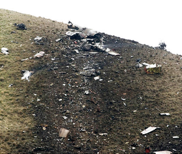
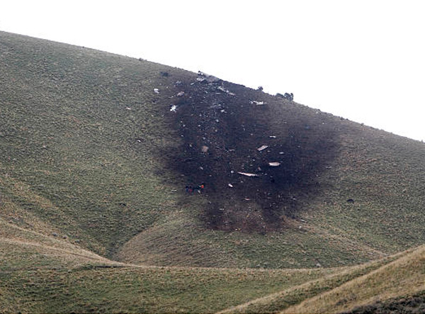
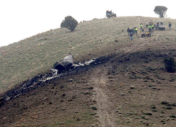
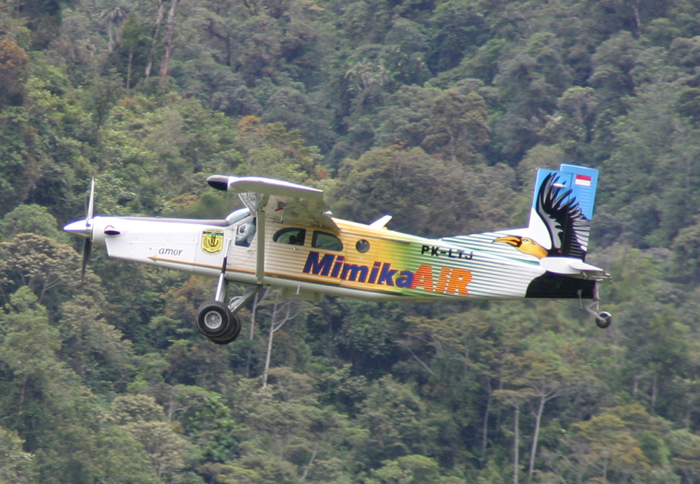
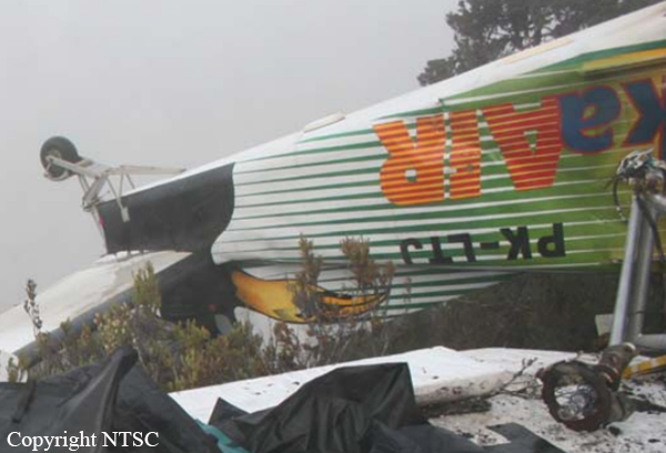
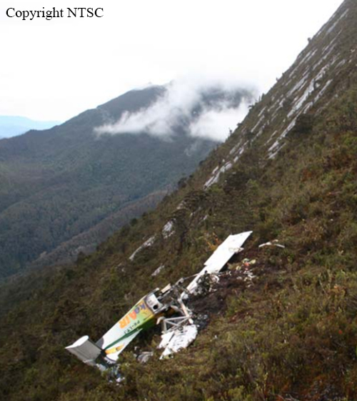
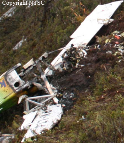
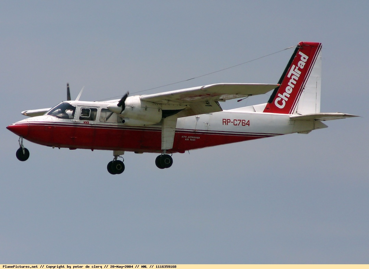
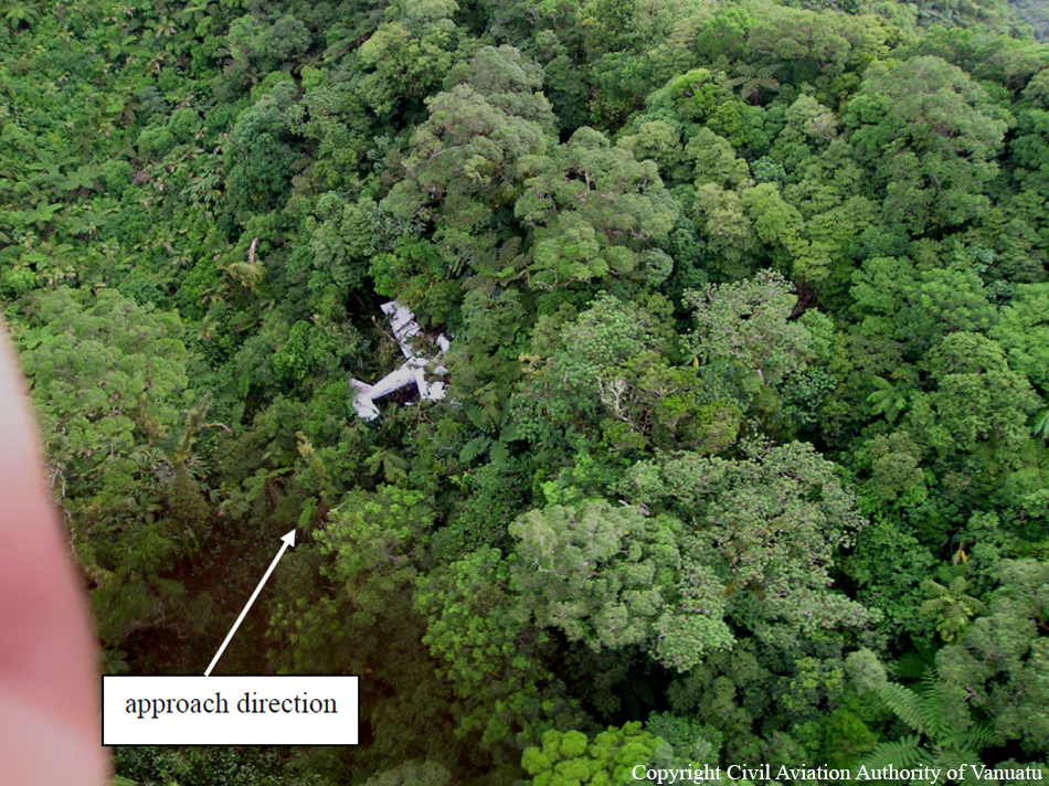
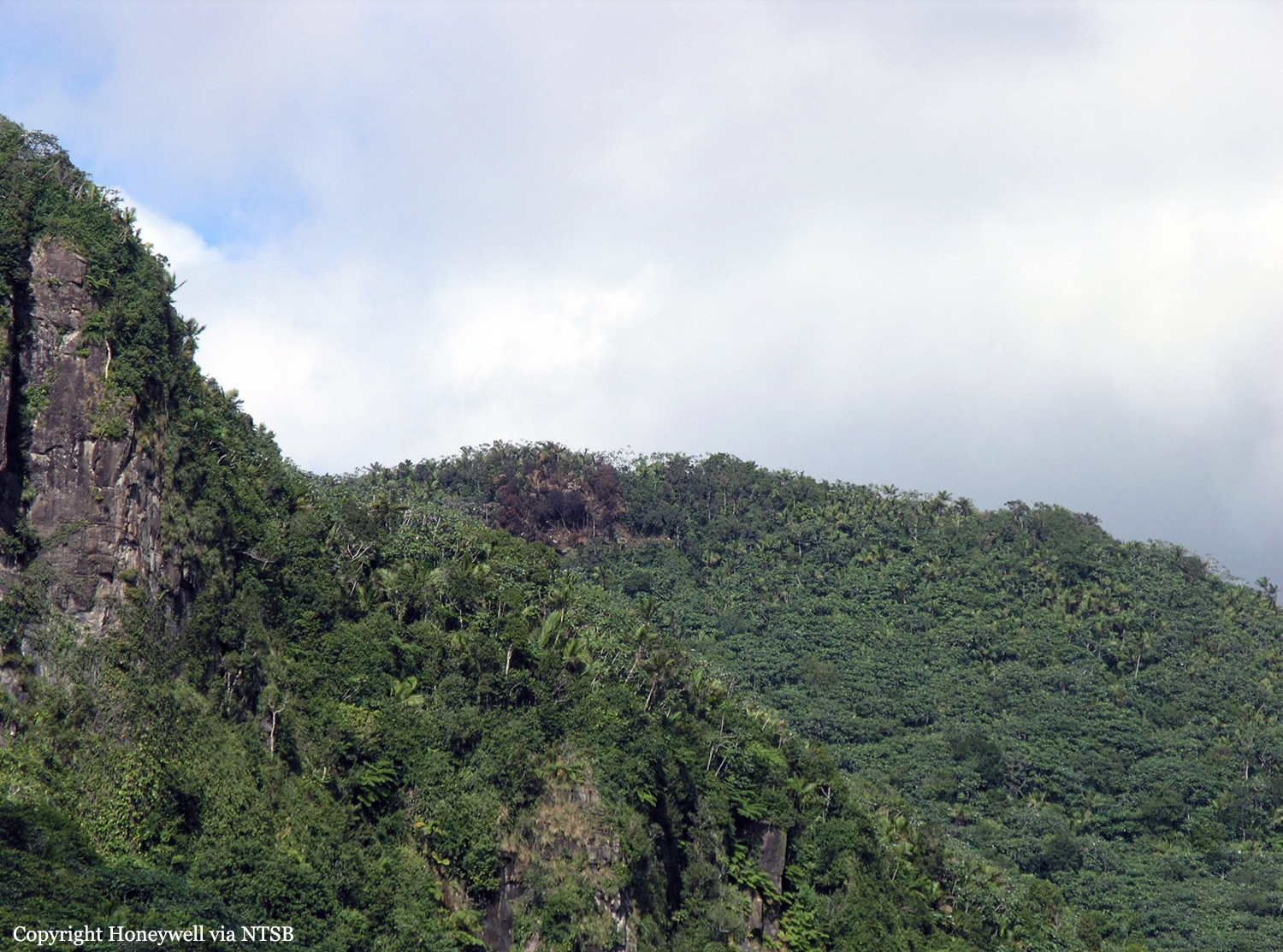
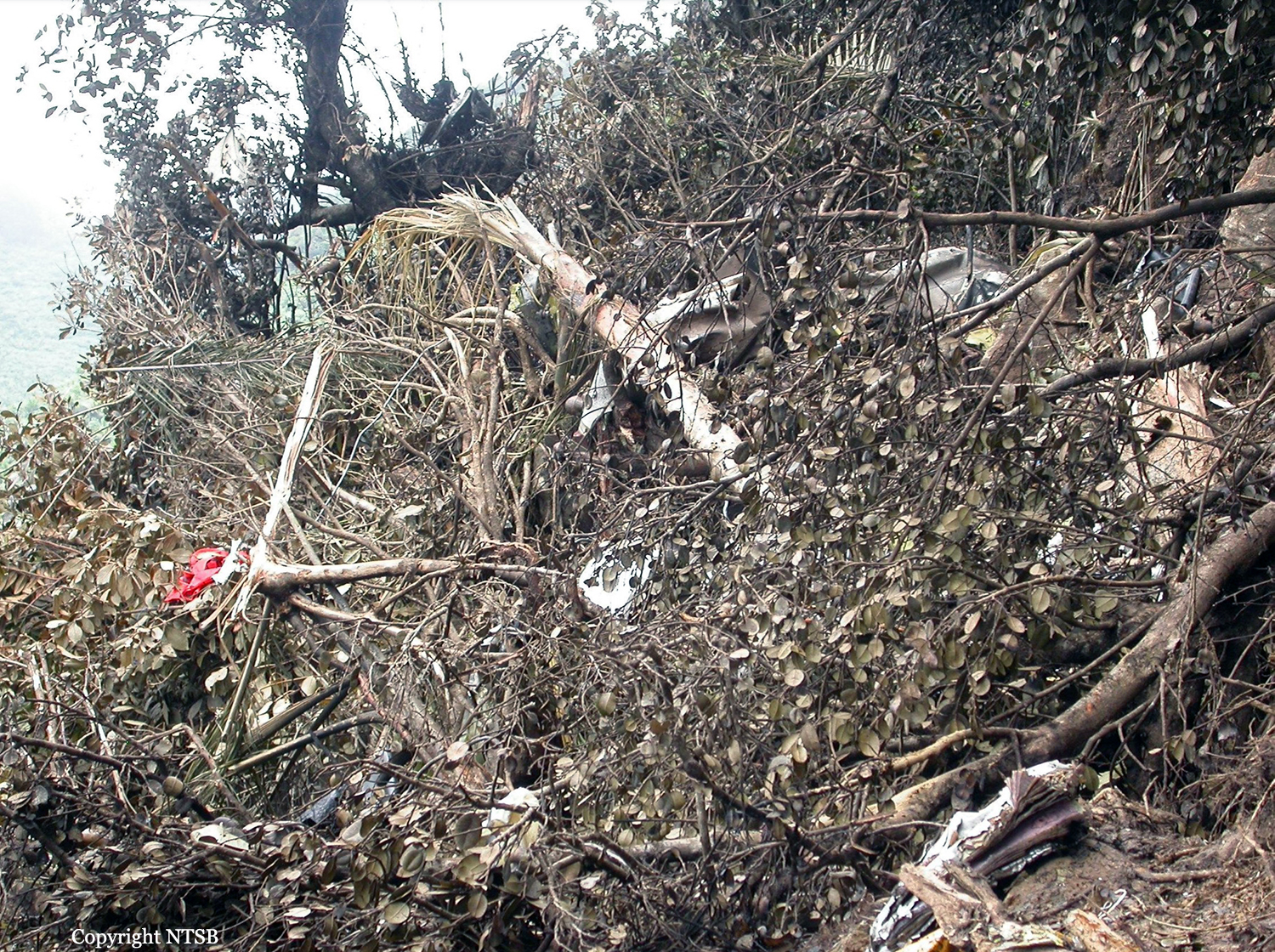
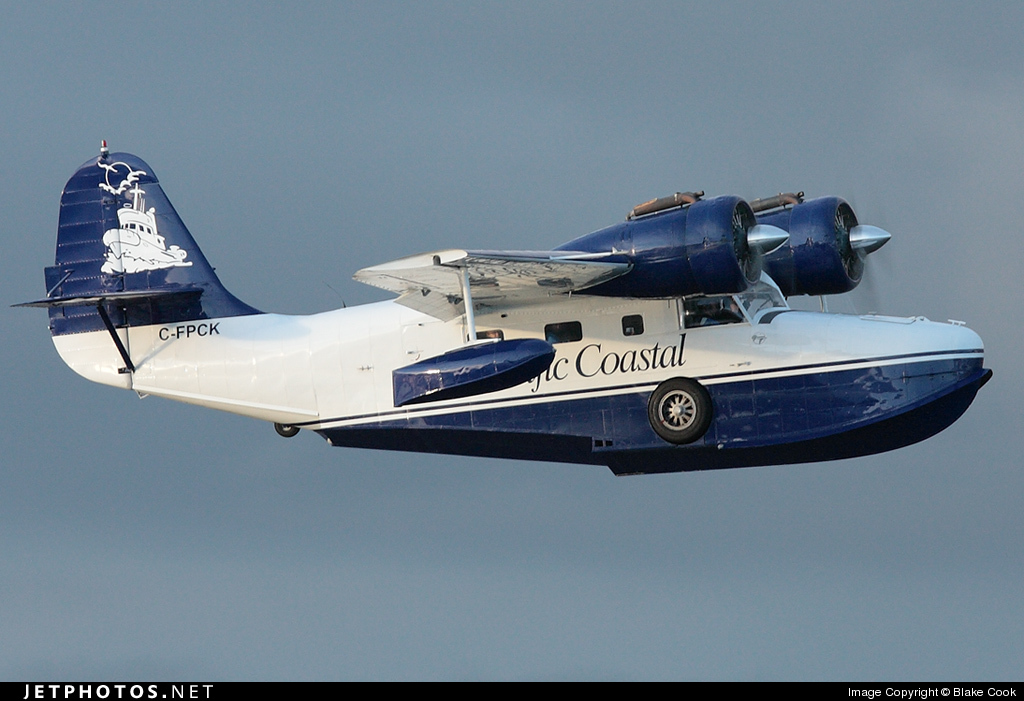
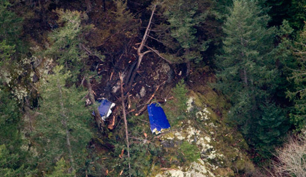
On Friday 19 December 2008, YJ-RV2, a Britten-Norman Islander aeroplane, was scheduled to fly a routine commercial passenger service for Air Vanuatu (Domestic) Limited (the operator). The service was to start from Bauerfield International Airport, Port Vila and was to include 5 flights or legs, taking the aircraft north via an intermediate landing at Norsup and onto Pekoa International Airport (also known as Santo Airport) near Luganville on Espiritu Santo. At Santo Airport the aircraft was to be refuelled and after a stopover of about 2 hours the service was to continue north to Gaua and Mota Lava before returning to Santo where it was planned to terminate. The pilot arrived at the operator’s base at about 0700 and started his before-flight duties. The flight departed Bauerfield on schedule at 0730 and progressed normally to Santo. The operator’s agent at Santo had early Friday morning called the company operations office in Port Vila and asked if a flight from Santo to Lajmoli and return could be added to the service. The regular Thursday flight had been cancelled and 9 passengers had been left stranded at Lajmoli. The operations staff approved the request and the agent advised he would confirm with the pilot of YJ-RV2 when he arrived at Santo. At Santo the pilot was met by the agent and agreed to the request for the additional flight to Lajmoli. No interruption to the original schedule was envisaged as the flight should have returned to Santo well before the planned 1230 departure north to Gaua. The aircraft was checked and 246 litres of fuel were added. The aircraft departed Santo for Lajmoli at 1016 with the pilot and 4 passengers onboard. At Lajmoli, the local agent, aware that YJ-RV2 was inbound, weighed the passengers and their bags in preparation for the return flight. At 1043 YJ-RV2 landed at Lajmoli and the agent off-loaded the passengers and baggage while the pilot waited by the aircraft. The agent later reported that he informed the pilot of the planned load of 9 passengers and baggage, and that the aircraft would likely be at about maximum allowable weight. The pilot was reported to have advised the agent that he was happy to continue and instructed him to load the aircraft. The pilot remained near the aircraft while the agent loaded first the baggage then the passengers. The pilot instructed one of the passengers to enter the aircraft through the forward door and sit in the front-right seat next to the pilot. The agent added the weight of the passengers and baggage to the load sheet for the flight, but he wasn’t aware of the fuel weight so omitted this from the sheet. The load sheet, which included a passenger manifest, was returned to the pilot, who signed it. A copy was retained by the agent and later handed to the investigation team. At 1055 the pilot started the engines and taxied the aircraft for grass runway 14. YJ-RV2 took off at 1058 and at 1100 the pilot called Santo air traffic services on the high frequency (HF) radio,reporting airborne and climbing to 7000 feet. He gave an estimated time of arrival at Santo of 130. Witnesses, both on the ground at Lajmoli and passengers on board, later commented that the aircraft took longer to get airborne than normal and was slower to climb. The pilot followed the coastline south and approaching the village of Wunavae turned left inland. Passengers later commented that the aircraft flew in a direct line towards the rising hilly ground and, based on their previous flying experiences, crossed several ridges at a lower-than-normal height. The passengers also commented that the pilot increased power on the engines as they flew in an easterly direction. The passengers later spoken to (7) reported no significant turbulence and while there was perhaps some light cloud about, they were able to see the terrain ahead. The passengers recalled becoming increasingly concerned about the low height of the aircraft as it flew directly at a right-angle towards the last ridgeline before crossing over into Big Bay. Some of the passengers described the pilot closing the throttles and shutting down the engines as they approached the ridgeline. At about the same time they heard a loud buzzing sound, later identified as the aircraft’s stall warning. Shortly afterwards, the aircraft struck the trees and bush and quickly came to a halt. No communication was heard from the pilot during this time, although he was observed throughout making movements typical of someone who was awake. Within a couple of minutes of impacting into the bush, the passengers started vacating the aircraft. Fuel was smelled about the aircraft and seen dripping from the wing. The passengers were unable to rouse the pilot and front-seat passenger, who were trapped in the now-deformed front of the aircraft. A second passenger, who had suffered a severe head wound and suspected broken leg, was slower to vacate the aircraft and remained semi-conscious near its right side. The remaining 7 passengers assembled at the rear of the aircraft, near the rear left baggage door. Thinking that the pilot and front-seat passenger were dead, and fearing the aircraft might catch fire, they agreed to start walking downhill towards the coast and Wunavae village. The eighth passenger, now aware that the main group had departed downhill, attempted to follow but was unable to catch up owing to his injuries. At about 1115, Santo air traffic services called the pilot of YJ-RV2 to coordinate his arrival with those of several other aircraft also approaching Santo. The controller received no response, so requested other aircraft to call YJ-RV2 on various radio frequencies. Again there was no response. At 1130 the controller declared the aircraft overdue and informed the authorities and the operator. The crews of a company ATR 42 and a DH6 Twin Otter on scheduled local flights were asked to conduct an initial search for YJ-RV2, focusing on the direct track from Lajmoli to Santo. A third private aircraft also assisted in the search. At about 1245 the crew of the ATR 42 located the wreckage of YJ-RV2 at about 4000 feet (1200 m) in the mountainous area west of Big Bay. The crew was unable to fly close enough to confirm if there were any survivors. At 1500, a light helicopter based in Port Vila departed for Santo and the accident site. Inclement weather prevented the helicopter reaching the site that evening and rescue operations were halted until the next day. Additional support was also requested from New Caledonia, and a French military Super Puma helicopter and medical team arrived in Santo on Saturday morning. At about 0700 on Saturday 20 December, the first rescue personnel reached YJ-RV2 and confirmed that the pilot was dead and the front-seat passenger critically injured. There was no sign of the remaining 8 passengers. The critically injured passenger was initially evacuated to Luganville Hospital and was subsequently taken to Australia for further treatment. He died of his injuries on 1 January 2009. During Saturday morning a group of searchers from Wunavae village started walking towards the accident site looking for survivors. About mid-afternoon, the group of 7 passengers was located by the crew of the Super Puma some 3 to 4 km west of the accident site and airlifted to Santo for treatment. The last passenger was located by the villagers the following day and after a third night in the bush was airlifted to hospital.
Probable cause:
Findings:
Findings are listed in order of development and not in order of priority.
- The pilot was appropriately licensed to fly the aeroplane, but his route and aerodrome qualification had been allowed to lapse. However, this lapse was unlikely to have contributed to the accident.
- There was no evidence that the pilot was not fit to conduct the flight, but he was observed by the local agent and passengers to be less communicative than usual, both before and during the flight.
- The aeroplane had been maintained in accordance with approved standards and there was no evidence of mechanical failure that could have contributed to the accident.
- The weather was suitable for the pilot to maintain appropriate terrain separation visually.
- The aeroplane was overloaded by at least 7%, which affected its climb performance and made it unlikely that it would be able to cross the final ridge without deviating from the path flown by the
pilot.
- The aeroplane did not have sufficient height margin to approach the lee of the ridge where downdraughts were foreseeable, and the pilot had not approached the ridge from a direction that
would have afforded him an escape route when he decided to abort the crossing.
- The poor configuration of the seat belts in the aeroplane increased the risk of injury to the occupants, and may have contributed to the death of one passenger.
- The chances of survival for those passengers who survived the impact were reduced by their decision to leave the accident site.
Final Report:

Crash of a Rockwell Grand Commander 690B in the El Yunque National Forest: 3 killed

Date & Time: Dec 3, 2008 at 1205 LT
Operator:
Registration:
N318WA
Flight Phase:
Survivors:
No
Site:
Schedule:
Tortola – San Juan
MSN:
690-11444
YOM:
1978
Country:
Crew on board:
1
Crew fatalities:
Pax on board:
2
Pax fatalities:
Other fatalities:
Total fatalities:
3
Captain / Total flying hours:
9600
Aircraft flight hours:
5286
Circumstances:
The charter flight departed for the destination, where the passengers would connect with another airline flight. The instrument-rated pilot may have felt pressured as the flight departed late. The accident airplane approached the destination airport from the east, descending at 250 knots ground speed from 8,800 feet above mean sea level (msl), on a 270 degree assigned heading, and was instructed to enter the right downwind for runway 10. The airplane's altitude readout was then observed by the approach controller to change to "XXX." The pilot was queried regarding his altitude and he advised that he was descending to 3,200 feet msl. The pilot was asked to confirm that he was in visual flight rules (VFR) conditions and was advised that the minimum vectoring altitude (MVA) for the area was 5,500 feet msl. The pilot responded that “We just ahh,” at which time the controller advised that she missed his transmission and asked him to repeat it. The pilot stated “Ahh roger, could we stay right just a little, we are in and out of some clouds right now.” The controller advised the pilot to “Maintain VFR” and again of the MVA. The controller then made multiple attempts to contact the pilot without result. The wreckage was discovered on the side of a mountain, where the airplane impacted after entering instrument meteorological conditions. Because aircraft operating in VFR flight are not required to comply with minimum instrument altitudes, aircraft receiving VFR radar services are not automatically afforded Minimum Safe Altitude Warning services except by pilot request. The controller's query to the pilot about his altitude and flight conditions was based on her observation of the loss of altitude reporting information. The pilot had not indicated any difficulty in maintaining VFR flight or terrain clearance up to that point. His comment that the aircraft was "in and out of some clouds" was her first indication that the pilot was not operating in visual conditions, and came within seconds of impact with the terrain. The controller was engaged in trying to correct the situation, and despite having been advised of the minimum vectoring altitude, the pilot continued to descend. The airplane was equipped with a terrain avoidance warning system but it could not be determined if it was functional. The pilot owned the charter operation. Documents discovered in the wreckage identified the pilot and airplane as operating for a different company since the pilot did not have the permissions necessary to operate in the United Kingdom Overseas Territories.
Probable cause:
The pilot's continued visual flight into instrument meteorological conditions, which resulted in an in-flight collision with terrain.
Final Report:

Crash of a Grumman G-21A Goose on Thormanby Island: 7 killed

Date & Time: Nov 16, 2008 at 1032 LT
Type of aircraft:
Operator:
Registration:
C-FPCK
Flight Phase:
Survivors:
Yes
Site:
Schedule:
Vancouver - Powell River
MSN:
1187
YOM:
1942
Country:
Crew on board:
1
Crew fatalities:
Pax on board:
7
Pax fatalities:
Other fatalities:
Total fatalities:
7
Captain / Total flying hours:
12000
Captain / Total hours on type:
8000.00
Circumstances:
At about 1013 Pacific Standard Time, the amphibious Grumman G-21A (registration C-FPCK, serial number 1187), operated by Pacific Coastal Airlines, departed from the water aerodrome at the south terminal of the Vancouver International Airport, British Columbia, with one pilot and seven passengers for a flight to Powell River, British Columbia. Approximately 19 minutes later, the aircraft crashed in dense fog on South Thormanby Island, about halfway between Vancouver and Powell River. Local searchers located a seriously injured passenger on the eastern shoreline of the island at about 1400. The aircraft was located about 30 minutes later, on a peak near Spyglass Hill, British Columbia. The pilot and the six other passengers were fatally injured, and the aircraft was destroyed by impact and post-crash fire. The emergency locator transmitter was destroyed and did not transmit.
Probable cause:
Findings as to Causes and Contributing Factors
1. The pilot likely departed and continued flight in conditions that were below visual
flight rules (VFR) weather minima.
2. The pilot continued his VFR flight into instrument meteorological conditions (IMC),
and did not recognize his proximity to terrain until seconds before colliding with
Thormanby Island, British Columbia.
3. The indication of a marginal weather improvement at Powell River, British Columbia,
and incorrect information from Merry Island, British Columbia, may have
contributed to the pilot’s conclusion that weather along the route would be sufficient
for a low-level flight.
Findings as to Risk:
1. The reliance on a single VHF-AM radio for commercial operations, particularly in congested airspace, increases the risk that important information is not received.
2. Flights conducted at low altitude greatly decrease VHF radio reception range, making it difficult to obtain route-related information that could affect safety.
3. The lack of pilot decision making (PDM) training for VFR air taxi operators exposes pilots and passengers to increased risk when faced with adverse weather conditions.
4. Some operators and pilots intentionally skirt VFR weather minima, which increases risk to passengers and pilots travelling on air taxi aircraft in adverse weather conditions.
5. Customers who apply pressure to complete flights despite adverse weather can negatively influence pilot and operator decisions.
6. Incremental growth in Pacific Coastal’s support to Kiewit did not trigger further risk analysis by either company. As a result, pilots and passengers were exposed to increased risks that went undetected.
7. Transport Canada’s guidance on risk assessment does not address incremental growth for air operators. As a result, there is increased risk that operators will not conduct the appropriate risk analysis as their operation grows.
8. Previous discussions between Pacific Coastal and the pilot about his weather decision making were not documented under the company’s safety management system (SMS). If hazards are not documented, a formal risk analysis may not be prompted to define and mitigate the risk.
9. There were no company procedures or decision aids (that is, decision tree, second pilot input, dispatcher co-authority) in place to augment a pilot’s decision to depart.
10. Because the aircraft’s emergency locator transmitter (ELT) failed to operate after the crash, determining that a crash had occurred and locating the aircraft were delayed.
11. On a number of flights, pilots on the Vancouver–Toba Inlet route, British Columbia, departed over maximum gross weight due to incorrectly calculated weight and balances. Risks to pilots and passengers are increased when the aircraft is operating outside approved limits.
12. The over-reliance on global positioning system (GPS) in conditions of low visibility and ceilings presents a significant safety risk to pilots and passengers.
Other Finding:
1. The SPOT Satellite Messenger data transmitted before the crash helped to narrow the search area and reduce the search time to find the aircraft. The fact that the wrong data were consulted caused an initial delay in reporting the missing aircraft.
Final Report:

Crash of a Cessna 402C in Monterrey: 3 killed

Date & Time: Oct 17, 2008 at 1210 LT
Type of aircraft:
Operator:
Registration:
XC-HAQ
Flight Phase:
Flight Type:
Survivors:
No
Site:
Schedule:
Monterrey – La Paz
MSN:
402C-0521
YOM:
1981
Country:
Crew on board:
2
Crew fatalities:
Pax on board:
1
Pax fatalities:
Other fatalities:
Total fatalities:
3
Circumstances:
The twin engine aircraft departed Monterrey-General Mariano Escobido Airport at 1200LT on a flight to La Paz, Baja California Sur with one passenger and two pilots on board. While climbing in clouds, the aircraft struck the slope of Mt El Fraile. The wreckage was found at the end of the afternoon. The aircraft was destroyed by impact forces and a post crash fire and all three occupants were killed, among them Nabor García Aguirre, Baja California Sur State Government Finance Secretary.
Crew:
Jaime Emilio Real Cosío, pilot,
Armando Ávila Ochoa, copilot.
Passenger:
Nabor García Aguirre.
Probable cause:
Controlled flight into terrain.