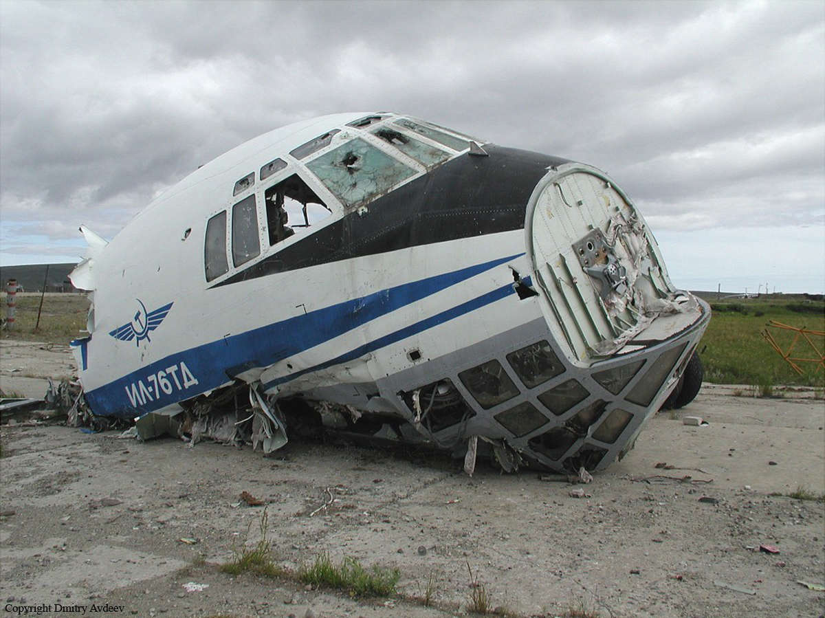
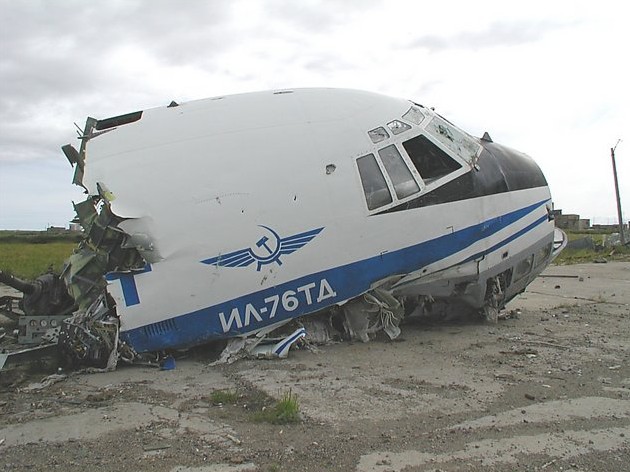
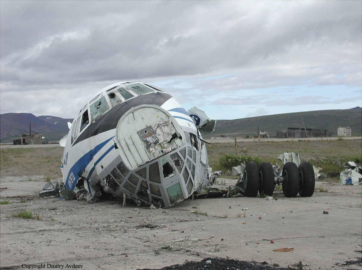
Crash of an Ilyushin II-76TD in Anadyr

Date & Time: Jan 25, 1997 at 1454 LT
Type of aircraft:
Operator:
Registration:
RA-76834
Flight Phase:
Flight Type:
Survivors:
Yes
Schedule:
Anadyr – Magadan – Moscow
MSN:
10234 09319
YOM:
1992
Country:
Region:
Crew on board:
9
Crew fatalities:
Pax on board:
16
Pax fatalities:
Other fatalities:
Total fatalities:
0
Aircraft flight hours:
3309
Aircraft flight cycles:
1083
Circumstances:
During the takeoff roll, at a speed of 290 km/h, the copilot started the rotation. The aircraft lifted off, reached a height of 7 metres then entered a left bank of 3,5°. Following a course of 665 metres, the aircraft entered a critical angle of attack, nosed up to 35° then landed back on the runway while the undercarriage have just been retracted. The aircraft slid on its belly and came to rest 270 metres further, about 120 metres to the left of the runway centerline. All 25 occupants were rescued, among them two were seriously injured. The aircraft was damaged beyond repair.
Probable cause:
It was determined that the captain decided to seat on the right front seat, letting the command to the copilot seating in the left front seat, which was against the published procedures because the copilot was not authorized and did not have sufficient experience. The copilot forgot to extend the flaps in an appropriate angle for the takeoff procedure, which caused the aircraft to adopt a critical angle of attack after liftoff and to stall. Successives errors and poor crew coordination were considered as contributing factors as well as the fact that the crew failed to follow the pre-takeoff checklist and failed to identify that the aircraft was not properly configured for the takeoff procedure.

Crash of a Cessna 208B Grand Caravan in Edenton: 2 killed

Date & Time: Jan 2, 1997 at 1835 LT
Type of aircraft:
Operator:
Registration:
N802TH
Flight Type:
Survivors:
No
Schedule:
Manteo - Edenton
MSN:
208B-0179
YOM:
1989
Crew on board:
2
Crew fatalities:
Pax on board:
0
Pax fatalities:
Other fatalities:
Total fatalities:
2
Captain / Total flying hours:
2980
Captain / Total hours on type:
850.00
Aircraft flight hours:
3520
Circumstances:
During his weather briefing, the pilot was told that his destination weather was not available, and was provided weather for an airport about 10 miles north. He was briefed that low visibility due to fog prevailed. The flight departed earlier then usual because the company business manager was concerned that the weather at the destination airport was deteriorating, and if the airplane was not there earlier they might not get into the airport. At the time of the accident there was a power failure, and lights around the destination airport went out. The airplane had struck power lines and a support tower located on the approach end of runway 1 and runway 5, about 1/2 mile southwest of the airport. The airport had one NDB approach which was not authorized at night. The nearest recorded weather, about 10 miles north of the crash site, at the time of the accident was; '...ceiling 100, [visibility] 1/2 mile, fog, [temperature] 46 degrees F, dew point, 42 degrees F, winds 220 degrees at 5 [knots], altimeter 29.90 inches Hg. Witnesses reported that there was heavy fog at the airport and the visibility was below 1/4 mile.
Probable cause:
The pilot's continued VFR flight into instrument meteorological conditions. Factors in this accident were: fog, the low ceiling, and the dark night.
Final Report:

Crash of a Learjet 35A in Lebanon: 2 killed

Date & Time: Dec 24, 1996 at 1005 LT
Type of aircraft:
Registration:
N388LS
Flight Type:
Survivors:
No
Site:
Schedule:
Bridgeport - Lebanon
MSN:
35-388
YOM:
1981
Crew on board:
2
Crew fatalities:
Pax on board:
0
Pax fatalities:
Other fatalities:
Total fatalities:
2
Captain / Total flying hours:
4250
Captain / Total hours on type:
1000.00
Aircraft flight hours:
6897
Circumstances:
The first officer was in the left seat, flying the airplane, and the captain was in the right seat, for the positioning flight. Approaching the destination, the crew briefed, then attempted an ILS RWY 18 approach. The captain reported not receiving the localizer, when, in fact, the airplane was actually about 5 nautical miles to the left of it. Winds at the airport, about that time, were from 190 degrees true, at 5 knots; however, area winds at 6,000 feet were from 220 degrees, in excess of 40 knots. The crew executed a missed approach, but did not follow the missed approach procedures. The captain later requested, and received clearance for, the VOR RWY 25 approach. The captain partially briefed the approach to the first officer as the airplane neared the VOR, then subsequently "talked through" remaining phases of the approach as they occurred. The outbound course for the VOR RWY 25 approach was 066 degrees, and the minimum altitude outbound was 4,300 feet. After passing the VOR, the captain directed the first officer to maintain 4,700 feet. The airplane's last radar contact occurred as the airplane was proceeding outbound, 7 nautical miles northeast of the VOR, at 4,800 feet. As the airplane approached the course reversal portion of the procedure turn, the captain initially directed the first officer to turn the airplane in the wrong direction. When the proper heading was finally given, the airplane had been outbound for about 2 minutes. During the outbound portion of the course reversal, the captain told the first officer to descend the airplane to 2,900 feet, although the procedure called for the airplane to maintain a minimum of 4,300 feet until joining the inbound course to the VOR. During the inbound portion of the course reversal, the captain amended the altitude to 3,000 feet. As the airplane neared the inbound course to the VOR, the captain called out the outer marker. The first officer agreed, and the captain stated that they could descend to 2,300 feet. The first officer then noted that the VOR indications were fluctuating. The captain pointed out the VOR's continued reception, and the first officer noted, "but it's all over the place." Shortly thereafter, the first officer stated that he was descending the airplane to 2,300 feet. Three seconds later, the airplane impacted trees, then terrain. The wreckage was located at the 2,300-foot level, on rising mountainous terrain, 061 degrees magnetic, 12.5 nautical miles from the VOR. It was also 10.3 nautical miles prior to where a descent to 2,300 feet was authorized. There was no evidence that the crew used available DME information. There was also no evidence of pre-impact mechanical malfunction.
Probable cause:
The captain's failure to maintain situational awareness, which resulted in the airplane being outside the confines of the instrument approach; and the crew's misinterpretation of a stepdown fix passage, which resulted in an early descent into rising terrain. Factors included the captain's misreading of the instrument approach procedure, the crew's rushed and incomplete instrument approach briefing, their failure to use additional, available navigational aids, and their failure to account for the winds at altitude.
Final Report:

Crash of a Learjet 36A in Stephenville: 2 killed

Date & Time: Dec 6, 1996 at 0238 LT
Type of aircraft:
Operator:
Registration:
N14TX
Flight Type:
Survivors:
No
Schedule:
Grand Rapids – Stephenville – Shannon
MSN:
36-033
YOM:
1977
Country:
Crew on board:
2
Crew fatalities:
Pax on board:
0
Pax fatalities:
Other fatalities:
Total fatalities:
2
Captain / Total flying hours:
5700
Captain / Total hours on type:
3000.00
Copilot / Total flying hours:
2800
Copilot / Total hours on type:
400
Circumstances:
Learjet L36A (serial number 033), N14TX, was on an instrument flight rules (IFR) flight from Grand Rapids, Michigan, to Stephenville, Newfoundland. At 0216 Newfoundland standard time (NST1), N14TX was cleared by Gander Area Control Centre (ACC) for an approach to the Stephenville airport. The co-pilot contacted the St. John=s Flight Service Station (FSS) and advised that they would be conducting an approach to runway 28. The FSS specialist relayed the latest Stephenville weather observation and runway surface condition report to the aircraft and requested that the crew advise St. John=s FSS when they had landed. When the crew of N14TX did not report after landing at Stephenville, the St. John=s FSS specialist advised Gander ACC that the aircraft was missing, and a search was begun. Initial information received by the agencies searching for the missing aircraft did not include the aircraft=s last recorded radar position. The wreckage was located approximately three hours and ten minutes after the aircraft was reported missing, within the airport perimeter, close to the last observed aircraft radar position. The aircraft struck a service road embankment in an inverted, wings-level attitude. The two crew members were fatally injured. The accident occurred during the hours of darkness at approximately 0238 NST.
Probable cause:
Shortly after crossing the runway threshold, the aircraft began moving to the left of the runway. The motion probably was undetected by the pilot until the aircraft touched down off the left side of the runway surface. The pilot did not maintain the proper aircraft attitude during an attempted missed approach, and the aircraft struck the terrain.
Final Report:

Crash of a Douglas DC-3C in San Juan

Date & Time: Oct 31, 1996 at 0330 LT
Type of aircraft:
Registration:
N37AP
Flight Phase:
Flight Type:
Survivors:
Yes
Schedule:
San Juan - San Juan
MSN:
4430
YOM:
1942
Country:
Crew on board:
3
Crew fatalities:
Pax on board:
0
Pax fatalities:
Other fatalities:
Total fatalities:
0
Captain / Total flying hours:
4242
Captain / Total hours on type:
1256.00
Aircraft flight hours:
16179
Circumstances:
After takeoff from runway 09, a climbing left turn was made. At about 1,000 feet, the #2 (right) engine backfired, emitted flames, and lost power. The captain instructed the copilot to feather the #2 propeller, which the copilot initiated with the feathering button. When the captain requested gear and flap extension, the copilot released the feathering button which did not remain engaged, contrary to system design. The airplane had arrived on a left downwind abeam the landing area at 500 feet and 95 to 100 knots. The captain turned toward the runway, then he ordered the gear and flaps to be retracted and initiated a go-around by increasing the left throttle without increasing propeller speed. A right turn was then made, and the airplane eventually crashed about 3 miles from the runway. During a postaccident examination, the propellers were found unfeathered, and the right engine fuel selector was in the main tank position. The emergency procedure listed the best single engine speed as 85 knots. The procedure for engine fire/failure was to feather the propeller and to move the respective fuel selector to 'OFF.' Examination revealed the number 11 cylinder on the right engine was cracked. There was evidence of fire, adjacent to the cylinder on the cowling, which consisted of scorching, sooting, and a burned through area of the underside of the right engine cowling. The copilot indicated a previous problem with the feathering system, but maintenance records did not contain any previous discrepancies regarding this anomaly.
Probable cause:
failure of the #11 cylinder on the right (#2) engine, which resulted in an in-flight fire and loss of power in that engine; and a malfunction/failure of the #2 feathering system, which led to a subsequent forced landing before the flight crew could return to the airport. A factor related to the accident was failure of the flight crew to increase the left (#1) engine rpm (in accordance with emergency procedures) after loss of power in the #2 engine.
Final Report:

Crash of a De Havilland DHC-2 Beaver near Cassiar: 1 killed

Date & Time: Sep 22, 1996 at 2024 LT
Type of aircraft:
Operator:
Registration:
C-FIBP
Flight Phase:
Flight Type:
Survivors:
No
Site:
Schedule:
Watson Lake - Desolation Lake
MSN:
787
YOM:
1955
Country:
Crew on board:
1
Crew fatalities:
Pax on board:
0
Pax fatalities:
Other fatalities:
Total fatalities:
1
Circumstances:
The pilot, sole on board, was completing a positioning flight from Watson Lake to Desolation Lake. While cruising at an altitude of 5,000 feet, the single engine aircraft struck trees and crashed in a wooded area located in hilly terrain, about 114 km southwest from Watson Lake. The wreckage was found a day later and the pilot was killed.

Crash of a Cessna T207A Skywagon near Littlefield: 1 killed

Date & Time: Sep 20, 1996 at 1939 LT
Operator:
Registration:
N6468H
Flight Phase:
Flight Type:
Survivors:
No
Site:
Schedule:
Grand Canyon - Saint George
MSN:
207-0532
YOM:
1979
Crew on board:
1
Crew fatalities:
Pax on board:
0
Pax fatalities:
Other fatalities:
Total fatalities:
1
Captain / Total flying hours:
23000
Captain / Total hours on type:
7.00
Aircraft flight hours:
10009
Circumstances:
The airplane was being positioned to another airport at night. The flight was over mountainous terrain. The airplane collided with the top of a 4,600-foot bluff. The pilot had a history of transient global amnesia. Examination of the accident site revealed a 567-foot long wreckage path, oriented along the direct course line from the departure point to the destination. Damage to the engine and propeller indicated that the engine was developing power at impact.
Probable cause:
The pilot's failure to maintain clearance with terrain during descent for undetermined reasons. Contributing factors were the dark night and mountainous terrain.
Final Report:

Crash of a De Havilland DHC-6 Twin Otter 200 near Cutral Có

Date & Time: Aug 9, 1996 at 1810 LT
Operator:
Registration:
LV-LNY
Flight Phase:
Flight Type:
Survivors:
Yes
Site:
Schedule:
Cutral Có - Rincón de Los Sauces
MSN:
171
YOM:
1969
Country:
Crew on board:
2
Crew fatalities:
Pax on board:
0
Pax fatalities:
Other fatalities:
Total fatalities:
0
Circumstances:
Few minutes after takeoff from Cutral Có Airport, the crew continued under VFR mode over a hilly terrain and at an insufficient altitude. While trying to make an evasive manoeuvre to avoid ground contact, the aircraft struck the top of a hill with its right wing, stalled and crashed. Both pilots were seriously injured and the aircraft was destroyed.
Probable cause:
Impact of the aircraft against a mountain slope while attempting an evasive manoeuvre during a steep left turn. Decision of the crew to fly over hilly terrain below the minimum safe altitude under VFR mode. A contributing factor was the possible distraction of the crew during the last part of the flight over the canyon.

Crash of a Swearingen SA26T Merlin IIA in Whale Cove

Date & Time: Jun 20, 1996 at 1905 LT
Type of aircraft:
Operator:
Registration:
C-GTHN
Flight Type:
Survivors:
Yes
MSN:
T26-016
YOM:
1968
Country:
Crew on board:
2
Crew fatalities:
Pax on board:
0
Pax fatalities:
Other fatalities:
Total fatalities:
0
Circumstances:
After landing at Whale Cove Airport, the aircraft deviated to the left after a course of about 1,600 feet. It veered off runway, lost its undercarriage and came to rest. Both pilots escaped uninjured while the aircraft was damaged beyond repair.
Probable cause:
The aircraft deviated from the runway centerline after landing due to strong crosswinds gusting up to 31 knots. The certification limit for the aircraft in such conditions was 22 knots.

Crash of a Beechcraft UC-45J Expeditor in Miami

Date & Time: May 2, 1996 at 1052 LT
Type of aircraft:
Operator:
Registration:
N64819
Flight Type:
Survivors:
Yes
Schedule:
Miami - Fort Lauderdale
MSN:
5834
YOM:
1943
Crew on board:
1
Crew fatalities:
Pax on board:
0
Pax fatalities:
Other fatalities:
Total fatalities:
0
Captain / Total flying hours:
8064
Captain / Total hours on type:
2245.00
Aircraft flight hours:
4254
Circumstances:
During departure, the rubber connector for the fuel supply line to the right engine oil dilution valve split at the dilution valve on the aft side of the firewall. The engine would not operate unless the electric boost pump was turned on. While returning to the departure airport, a fire erupted in the right wheel after the landing gear was extended. The cockpit filled with smoke during the landing rollout, and the pilot lost directional control do to not being able to see. The aircraft rolled into a canal and came to rest. The split rubber fuel line connector was dry and brittle and did not have any fire damage. No other sources of fuel leakage was found.
Probable cause:
Inadequate inspection of the fuel line connector by company maintenance personnel, and failure of a connector resulting in a fuel leak and fire.
Final Report: