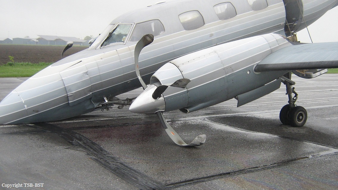
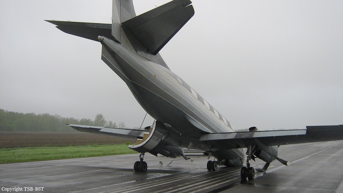
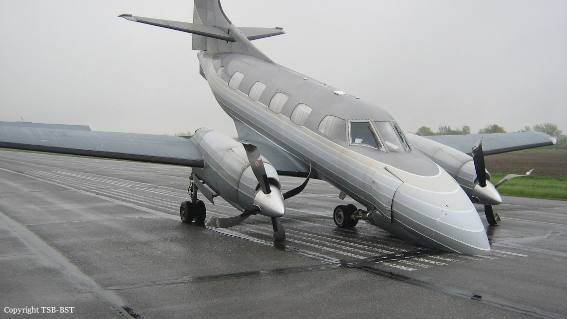
Crash of an Antonov AN-26 in Balashov: 1 killed

Date & Time: May 30, 2017 at 0640 LT
Type of aircraft:
Operator:
Registration:
RF-36160
Flight Type:
Survivors:
Yes
Schedule:
Balashov - Balashov
MSN:
80 01
YOM:
1979
Country:
Region:
Crew on board:
6
Crew fatalities:
Pax on board:
0
Pax fatalities:
Other fatalities:
Total fatalities:
1
Circumstances:
The crew was performing a local training mission at Balashov Airport, in the region of Saratov. Following several touch-and-go manoeuvres, the crew initiated a new approach. On final, the airplane descended below the MDA and, at a speed of 240 km/h, rolled to the right to an angle of 24°, stalled and crashed in a field located 1,100 metres from the airfield, bursting into flames. Five occupants were injures while a pilot under supervision was killed. The airplane had the dual registration RF-36160 and 79 red.
Crew:
Cpt Y. Tereshin,
Maj S. Rodionov,
Ens Frolov,
P. Halaimov,
I. Makhmoudov,
M. Artemiev. †
Probable cause:
It was determined that during the approach, the instructor led the aircraft descending below MDA when he simulated an engine failure and positioned both power levers to idle. As a result of the failure of the propeller feathering system, the right engine stopped. After 14 seconds, the instructor mistakenly shut down the left engine that was running properly, causing the aircraft to lose speed, to stall and to crash.

Crash of a Let L-410UVP-E20 in Lukla: 2 killed

Date & Time: May 27, 2017 at 1404 LT
Type of aircraft:
Operator:
Registration:
9N-AKY
Flight Type:
Survivors:
Yes
Schedule:
Kathmandu – Lukla
MSN:
14 29 17
YOM:
2014
Flight number:
GO409
Country:
Region:
Crew on board:
3
Crew fatalities:
Pax on board:
0
Pax fatalities:
Other fatalities:
Total fatalities:
2
Captain / Total flying hours:
9687
Captain / Total hours on type:
1897.00
Copilot / Total flying hours:
1311
Copilot / Total hours on type:
1028
Aircraft flight hours:
2550
Aircraft flight cycles:
5467
Circumstances:
On May 27, 2017 9N-AKY, LET 410 UVP-E20 of Goma Air (now Summit Air), a domestic carrier of Nepal had a published program to operate 5 flights to Lukla from Kathmandu. The first flight departed Kathmandu at 0026 UTC. By the time 0647 UTC they had completed 4 flights. The fifth and the last flight departed Kathmandu at 0744 UTC for Lukla as call sign Goma Air 409. Goma Air 409 was the cargo flight carrying 1680 kg cargo for Lukla. There were two cockpit crews, one cabin crew and no passengers on board the flight. It was pre-monsoon period. Lukla weather on that particular day was cloudy since morning. But ceiling and visibility were reported OK. However, CCTV footage shows rapidly deteriorating weather condition before and after the crash. Automatic VHF recorder of Lukla Tower and CVR recording showed Tower was regularly updating pilots of deteriorating weather. All the pre-and post-departure procedure of the flight was completed in normal manner. Before departure from Kathmandu Pilots were found to have obtained latest weather of Lukla, Phaplu and Rumjatar. PIC decided to remain south of track to avoid the terrain and cloud. When Goma 409 was about 11 miles East from Kathmandu they were informed that Lukla was having heavy rain and airport closed. By that time air traffic congestion in TIA was slowly developing. Traffics were holding in the air and in the ground as well. So Goma 409 continued for Lukla. However, after crossing 26 miles from Kathmandu, they were again informed that the rain had ceased and airport was open. An AS350 helicopter, 9N AGU which departed Lukla at 0803 UTC for Kathmandu had reported unstable wind on final Runway 06. Enroute weather reported by 9N AGU upon request of Lukla Tower was good beyond the Lukla valley. However, it was apprehended that for fixed wing, weather might be difficult to enter valley. Lukla Tower relayed all available information when Goma Air 409 had first established contact at time 0810 UTC. Later, Goma Air and 9N AGY, two reciprocal traffics were also in contact each other. 9N AGY relayed the actual weather status to GOMA AIR. Lukla valley's ceiling and visibility was OK for VFR until 0812UTC ( 6 minutes before crash). Weather started to deteriorate very fast. Mountain Ridges were visible through thin layer of foggy cloud until 0814 UTC. After one minute (approx.) Right Base for Runway 06, was covered up and cloud from left base was moving towards final. Duty ATS Officer of Lukla Tower was regularly up dating pilots about deteriorating weather condition. However, Tower was found to be failed to close the runway as per SOP in spite of rapidly deterioratingweather. Pilots ventured to continue though the weather was marginal. Aircraft reported entering valley at 0816. CVR record showed that First Officer sighted the runway at 0817 (64 seconds before the impact). Instantly PIC acknowledged he had also the runway in sight. Aircraft was at 9100 ft (approx.) when the cockpit crews sighted the runway. It maintained 9000 feet (approx.) for further 21 seconds. At time 0817:12i.e. 48 seconds before the impact Tower gave the latest wind as Westerly 04 knots and runway was clear. PIC was still in doubt and asked whether there was rain. Upon confirmation of having no rain from the Tower the aircraft started to descend further. The PIC, who was also the PF, found to have lost situational awareness deviated to the right with continued descend. At 0817:35 (25 seconds before impact) when the flight was descending through 8650 ft First Officer warned PIC that they were too low. PIC did not respond the F/O's call-out and continued descend. On reaching 8500 ft. F/O again warned PIC in panic. Then PIC asked in panic where the runway was. F/O directed towards the runway. But it was already too low and too late. There was initially two short stall warning sound. Then a continuous stall warning sounded till the impact, which lasted for 13 seconds. The last words in CVR records was "w]/ gtfg " (Do not pull too much). Abrupt change in aircraft attitude in an attempt to climb and reach threshold height at 8900 ft. (on Kathmandu QNH) in a landing configuration, with landing gears down and on full flaps, created excessive drag resulting the aircraft to stall. Subsequently, its left wing first hit a small tree branch 180 ft. short of the threshold. Then impacted the sloppy terrain 100ft. short of the runway. After the crash aircraft engine was reported to be running for about a minute. But there was no postcrash fire. Aircraft was totally damaged by the impact.
Crew:
Paras Kumar Rai, pilot, †
Srijan Manandhar, copilot, †
Pragya Maharjan, cabin crew.
Probable cause:
The Commission concludes that the probable cause of this accident was aircraft stall as a result of excessive drag created by sudden increase in angle of attack of the aircraft supplemented by low speed (below Vref) in an attempt to initiate immediate climb on a landing configuration (full flap and landing gear down) warranted by the critical situation of the final phase of flight.
Contributing factors:
- Critical terrain and rapidly deteriorating weather condition.
- Pilot's loss of situational awareness.
- Improper pilot response to stall warning including failure to advance power lever to maximum at appropriate time.
- Violation of SOP by the ATS and Pilot as well.
Final Report:

Crash of a Swearingen SA226T Merlin IIIB in Arnprior

Date & Time: May 26, 2017
Operator:
Registration:
C-GFPX
Flight Type:
Survivors:
Yes
Schedule:
North Bay - Arnprior
MSN:
T-310
YOM:
1979
Country:
Crew on board:
2
Crew fatalities:
Pax on board:
1
Pax fatalities:
Other fatalities:
Total fatalities:
0
Circumstances:
The twin engine airplane departed North Bay on an ambulance flight to Arnprior, carrying two pilots and a doctor. Following an uneventful flight, the crew was cleared for a VOR/DME approach to runway 28 under VFR conditions. On short final, the aircraft descended too low and impacted ground 50 metres short of runway. Upon impact, the nose gear collapsed and the airplane slid for about 600 metres before coming to rest. All three occupants evacuated safely and the aircraft was damaged beyond repair.

Crash of a De Havilland DHC-6 Twin Otter 300 at Perris Valley

Date & Time: May 24, 2017 at 1515 LT
Operator:
Registration:
N708PV
Survivors:
Yes
Schedule:
Perris Valley - Perris Valley
MSN:
489
YOM:
1976
Crew on board:
2
Crew fatalities:
Pax on board:
0
Pax fatalities:
Other fatalities:
Total fatalities:
0
Captain / Total flying hours:
3358
Captain / Total hours on type:
2131.00
Copilot / Total flying hours:
1893
Copilot / Total hours on type:
12
Aircraft flight hours:
37885
Circumstances:
The pilot of the twin-engine, turbine-powered airplane reported that, while providing flights for skydivers throughout the day, he had a potential new hire pilot flying with him in the right seat. He added that, on the eighth flight of the day, the new pilot was flying during the approach and "approximately 200 feet south from the threshold of [runway] 15 at approximately 15 feet AGL [above ground level] the bottom violently and unexpectedly dropped out. [He] believe[d] some kind of wind shear caused the aircraft [to] slam onto [the] runway and bounce into the air at a 45 to 60-degree bank angle to the right." The prospective pilot then said, "you got it." The pilot took control of the airplane and initiated a go-around by increasing power, which aggravated the "off runway heading." The right wing contacted the ground, the airplane exited the runway to the right and impacted a fuel truck, and the right wing separated from the airplane. The impact caused the pilot to unintentionally add max power, and the airplane, with only the left engine functioning, ground looped to the right, coming to rest nose down.
Probable cause:
The prospective pilot's improper landing flare and the pilot's delayed remedial action to initiate a go-around, which resulted in a runway excursion.
Final Report:

Crash of a Pilatus PC-6/B2-H4 Turbo Porter in Cecina

Date & Time: May 20, 2017 at 1200 LT
Operator:
Registration:
S5-CEI
Survivors:
Yes
Schedule:
Cecina - Cecina
MSN:
778
YOM:
1977
Location:
Country:
Region:
Crew on board:
1
Crew fatalities:
Pax on board:
0
Pax fatalities:
Other fatalities:
Total fatalities:
0
Circumstances:
The pilot, sole on board, was returning to Cecina Airfield following a skydiving flight in the area. After touchdown on a grassy area, the single engine aircraft veered to the left, impacted a drainage ditch and came to rest. The pilot escaped uninjured and the aircraft was damaged beyond repair.

Crash of a Learjet 25B in Toluca: 2 killed

Date & Time: May 17, 2017 at 1525 LT
Type of aircraft:
Operator:
Registration:
XA-VMC
Flight Phase:
Flight Type:
Survivors:
No
Schedule:
Toluca - Durango
MSN:
25-114
YOM:
1973
Location:
Country:
Crew on board:
2
Crew fatalities:
Pax on board:
0
Pax fatalities:
Other fatalities:
Total fatalities:
2
Aircraft flight hours:
14654
Aircraft flight cycles:
13449
Circumstances:
During the takeoff roll on runway 15 at Toluca-Licendiado Adolfo López Mateos, after the airplane passed the V1 speed, the warning light came on in the cockpit panel, informing the crew about the deployment of the reverse on the left engine. According to published procedures, the crew continued the takeoff and shortly after rotation, during initiale climb, the aircraft rolled to the left and crashed in an open field, bursting into flames. The wreckage was found about 200 metres past the runway end. The aircraft was destroyed and both pilots were killed.
Probable cause:
Probable Cause:
Loss of control of the aircraft during the emergency procedure of indication of the deployment of the reverse of the engine number one during the takeoff roll above V1, which was consistent with the training and standard operating procedures that call to continue the takeoff, causing the collapse of the aircraft, by low speed and the operation of abrupt maneuvers and turns towards the engine side in idle position and commanded opening of the Drag Shut due to poor CRM.
Contributing factors:
- False indication of reverse display of dwelling position number one.
- Failure of pilots of previous flights not to refer failures to indicate the deployment of reverses for maintenance actions.
Final Report:

Crash of a Learjet 35A in Teterboro: 2 killed

Date & Time: May 15, 2017 at 1529 LT
Type of aircraft:
Registration:
N452DA
Flight Type:
Survivors:
No
Schedule:
Philadelphia - Teterboro
MSN:
35A-452
YOM:
1981
Crew on board:
2
Crew fatalities:
Pax on board:
0
Pax fatalities:
Other fatalities:
Total fatalities:
2
Captain / Total flying hours:
6898
Captain / Total hours on type:
353.00
Copilot / Total flying hours:
1167
Copilot / Total hours on type:
407
Circumstances:
On May 15, 2017, about 1529 eastern daylight time, a Learjet 35A, N452DA, departed controlled flight while on a circling approach to runway 1 at Teterboro Airport (TEB), Teterboro, New Jersey, and impacted a commercial building and parking lot. The pilot-in-command (PIC) and the second-in-command (SIC) died; no one on the ground was injured. The airplane was destroyed by impact forces and postcrash fire. The airplane was registered to A&C Big Sky Aviation, LLC, and was operated by Trans-Pacific Air Charter, LLC, under the provisions of Title 14 Code of Federal Regulations (CFR) Part 91 as a positioning flight. Visual meteorological conditions prevailed, and an instrument flight rules flight plan was filed. The flight departed from Philadelphia International Airport (PHL), Philadelphia, Pennsylvania, about 1504 and was destined for TEB. The accident occurred on the flight crew’s third and final scheduled flight of the day; the crew had previously flown from TEB to Laurence G. Hanscom Field (BED), Bedford, Massachusetts, and then from BED to PHL. The PIC checked the weather before departing TEB about 0732; however, he did not check the weather again before the flight from PHL to TEB despite a company policy requiring that weather information be obtained within 3 hours of departure. Further, the crew filed a flight plan for the accident flight that included altitude (27,000 ft) and time en route (28 minutes) entries that were incompatible with each other, which suggests that the crew devoted little attention to preflight planning. The crew also had limited time in flight to plan and brief the approach, as required by company policy, and did not conduct an approach briefing before attempting to land at TEB. Cockpit voice recorder data indicated that the SIC was the pilot flying (PF) from PHL to TEB, despite a company policy prohibiting the SIC from acting as PF based on his level of experience. Although the accident flight waslikely not the first time that the SIC acted as PF (based on comments made during the flight), the PIC regularly coached the SIC (primarily on checklist initiation and airplane control) from before takeoff to the final seconds of the flight. The extensive coaching likely distracted the PIC from his duties as PIC and pilot monitoring, such as executing checklists and entering approach waypoints into the flight management system. Collectively, procedural deviations and errors resulted in the flight crew’s lack of situational awareness throughout the flight and approach to TEB. Because neither pilot realized that the airplane’s navigation equipment had not been properly set for the instrument approach clearance that the flight crew received, the crew improperly executed the vertical profile of the approach, crossing an intermediate fix and the final approach fix hundreds of feet above the altitudes specified by the approach procedure. The controller had vectored the flight for the instrument landing system runway 6 approach, circle to runway 1. When the crew initiated the circle-to-land maneuver, the airplane was 2.8 nautical miles (nm) beyond the final approach fix (about 1 mile from the runway 6 threshold) and could not be maneuvered to line up with the landing runway, which should have prompted the crew to execute a go-around because the flight did not meet the company’s stabilized approach criteria. However, neither pilot called for a go-around, and the PIC (who had assumed control of the airplane at this point in the flight) continued the approach by initiating a turn to align with the landing runway. Radar data indicated that the airplane’s airspeed was below the approach speed required by company standard operating procedures (SOPs). During the turn, the airplane stalled and crashed about 1/2 nm south of the runway 1 threshold.
Probable cause:
The National Transportation Safety Board determines that the probable cause of this accident was the pilot-in-command’s (PIC) attempt to salvage an unstabilized visual approach, which resulted in an aerodynamic stall at low altitude. Contributing to the accident was the PIC’s decision to allow an unapproved second-in-command to act as pilot flying, the PIC’s inadequate and incomplete preflight planning, and the flight crew’s lack of an approach briefing. Also contributing to the accident were Trans-Pacific Jets’ lack of safety programs that would have enabled the company to identify and correct patterns of poor performance and procedural noncompliance and the Federal Aviation Administration’s ineffective Safety assurance System procedures, which failed to identify these company oversight deficiencies.
Final Report:

Crash of a Short 330-200 in Charleston: 2 killed

Date & Time: May 5, 2017 at 0651 LT
Type of aircraft:
Operator:
Registration:
N334AC
Flight Type:
Survivors:
No
Schedule:
Louisville – Charleston
MSN:
SH3029
YOM:
1979
Flight number:
2Q1260
Crew on board:
2
Crew fatalities:
Pax on board:
0
Pax fatalities:
Other fatalities:
Total fatalities:
2
Captain / Total flying hours:
4368
Captain / Total hours on type:
578.00
Copilot / Total flying hours:
652
Copilot / Total hours on type:
333
Aircraft flight hours:
28023
Aircraft flight cycles:
36738
Circumstances:
The flight crew was conducting a cargo flight in instrument meteorological conditions. Takeoff from the departure airport and the en route portion of the flight were normal, with no reported weather or operational issues. As the flight neared Charleston Yeager International Airport (CRW) at an altitude of 9,000 ft, the captain and first officer received the most recent automatic terminal information service (ATIS) report for the airport indicating wind from 080º at 11 knots, 10 miles visibility, scattered clouds at 700 ft above ground level (agl), and a broken ceiling at 1,300 ft agl. However, a special weather observation recorded about 7 minutes before the flight crew's initial contact with the CRW approach controller indicated that the wind conditions had changed to 170º at 4 knots and that cloud ceilings had dropped to 500 ft agl. The CRW approach controller did not provide the updated weather information to the flight crew and did not update the ATIS, as required by Federal Aviation Administration Order 7110.65X, paragraph 2-9-2. The CRW approach controller advised the flight crew to expect the localizer 5 approach, which would have provided a straight-in final approach course aligned with runway 5. The first officer acknowledged the instruction but requested the VOR-A circling instrument approach, presumably because the approach procedure happened to line up with the flight crew's inbound flightpath and flying the localizer 5 approach would result in a slightly longer flight to the airport. However, because the localizer 5 approach was available, the flight crew's decision to fly the VOR-A circling approach was contrary to the operator's standard operating procedures (SOP). The minimum descent altitude (MDA) for the localizer approach was 373 ft agl, and the MDA for the VOR-A approach was about 773 ft agl. With the special weather observation indicating cloud cover at 500 ft agl, it would be difficult for the pilots to see the airport while at the MDA for the VOR-A approach; yet, the flight crew did not have that information. The approach controller was required to provide the flight crew with the special weather report indicating that the ceiling at the arrival airport had dropped below the MDA, which could have prompted the pilots to use the localizer approach; however, the pilots would not have been required to because the minimum visibility for the VOR-A approach was within acceptable limits. The approach controller approved the first officer's request then cleared the flight direct to the first waypoint of the VOR-A approach and to descend to 4,000 ft. Radar data indicated that as the flight progressed along the VOR-A approach course, the airplane descended 120 feet below the prescribed minimum stepdown altitude of 1,720 ft two miles prior to FOGAG waypoint. The airplane remained level at or about 1,600 ft until about 0.5 mile from the displaced threshold of the landing runway. At this point, the airplane entered a 2,500 ft-per-minute, turning descent toward the runway in a steep left bank up to 42º in an apparent attempt to line up with the runway. Performance analysis indicates that, just before the airplane impacted the runway, the descent rate decreased to about 600 fpm and pitch began to move in a nose-up direction, suggesting that the captain was pulling up as the airplane neared the pavement; however, it was too late to save the approach. Postaccident examination of the airplane did not identify any airplane or engine malfunctions or failures that would have precluded normal operation. Video and witness information were not conclusive as to whether the captain descended below the MDA before exiting the cloud cover; however, the descent from the MDA was not in accordance with federal regulations, which required, in part, that pilots not leave the MDA until the "aircraft is continuously in a position from which a descent to a landing on the intended runway can be made at a normal descent rate using normal maneuvers." The accident airplane's descent rate was not in accordance with company guidance, which stated that "a constant rate of descent of about 500 ft./min. should be maintained." Rather than continue the VOR-A approach with an excessive descent rate and airplane maneuvering, the captain should have conducted a missed approach and executed the localizer 5 approach procedure. No evidence was found to indicate why the captain chose to continue the approach; however, the captain's recent performance history, including an unsatisfactory checkride due to poor instrument flying, indicated that his instrument flight skills were marginal. It is possible that the captain felt more confident in his ability to perform an unstable approach to the runway compared to conducting the circling approach to land. The first officer also could have called for a missed approach but, based on text messages she sent to friends and their interview statements, the first officer was not in the habit of speaking up. The difference in experience between the captain and first officer likely created a barrier to communication due to authority gradient. ATC data of three VOR-A approaches to CRW flown by the captain over a period of 3 months before the accident and airport security footage of previous landings by the flight crew 1 month before the accident suggest that the captain's early descent below specified altitudes and excessive maneuvering during landing were not isolated to the accident flight. The evidence suggests that the flight crew consistently turned to final later and at a lower altitude than recommended by the operator's SOPs. The flight crew's performance on the accident flight was consistent with procedural intentional noncompliance, which—as a longstanding concern of the NTSB—was highlighted on the NTSB's 2015 Most Wanted List. The operator stands as the first line of defense against procedural intentional noncompliance by setting a positive safety attitude for personnel to follow and establishing organizational protections. However, the operator had no formal safety and oversight program to assess compliance with SOPs or monitor pilots, such as the captain, with previous performance issues.
Probable cause:
The flight crew's improper decision to conduct a circling approach contrary to the operator's standard operating procedures (SOP) and the captain's excessive descent rate and maneuvering during the approach, which led to inadvertent, uncontrolled contact with the ground. Contributing to the accident was the operator's lack of a formal safety and oversight program to assess hazards and compliance with SOPs and to monitor pilots with previous performance issues.
Final Report:

Crash of a Piper PA-31-310 Navajo in Schefferville: 2 killed

Date & Time: Apr 30, 2017 at 1756 LT
Type of aircraft:
Operator:
Registration:
C-FQQB
Survivors:
No
Schedule:
Schefferville - Schefferville
MSN:
31-310
YOM:
1968
Country:
Crew on board:
2
Crew fatalities:
Pax on board:
0
Pax fatalities:
Other fatalities:
Total fatalities:
2
Captain / Total flying hours:
461
Captain / Total hours on type:
110.00
Copilot / Total flying hours:
1693
Copilot / Total hours on type:
650
Aircraft flight hours:
20180
Circumstances:
The Piper PA-31 (registration C-FQQB, serial number 31-310) operated by Exact Air Inc., with 2 pilots on board, was conducting its 2nd magnetometric survey flight of the day, from Schefferville Airport, Quebec, under visual flight rules. At 1336 Eastern Daylight Time, the aircraft took off and began flying toward the survey area located 90 nautical miles northwest of the airport. After completing the magnetometric survey work at 300 feet above ground level, the aircraft began the return flight segment to Schefferville Airport. At that time, the aircraft descended and flew over the terrain at an altitude varying between 100 and 40 feet above ground level. At 1756, while the aircraft was flying over railway tracks, it struck power transmission line conductor cables and crashed on top of a mine tailings deposit about 3.5 nautical miles northwest of Schefferville Airport. Both occupants were fatally injured. The accident occurred during daylight hours. Following the impact, there was no fire, and no emergency locator transmitter signal was captured.
Probable cause:
Findings:
Findings as to causes and contributing factors:
- Sensation seeking, mental fatigue, and an altered risk perception very likely contributed to the fact that, immediately after completing the magnetometric survey work, the pilot flying descended to an altitude varying between 100 and 40 feet above ground level and maintained this altitude until the aircraft collided with the wires.
- It is highly likely that the pilots were unaware that there was a power transmission line in their path.
- The pilot flying did not detect the power transmission line in time to avoid it, and the aircraft collided with the wires, which were 70 feet above the ground.
- Despite the warning regarding low-altitude flying in the Transport Canada Aeronautical Information Manua, and in the absence of minimum-altitude restrictions imposed by the company, the pilot chose to descend to a very low altitude on the return flight; as a result, this flight segment carried an unacceptable level of risk.

Findings as to risk:
- If pilots fly at low altitude, there is a risk that they will collide with wires, given that these are extremely difficult to see in flight.
- If lightweight flight data recording systems are not used to closely monitor flight operations, there is a risk that pilots will deviate from established procedures and limits, thereby reducing safety margins.
- If Transport Canada does not take concrete measures to facilitate the use of lightweight flight data recording systems and flight data monitoring, there is a risk that operators will be unable to proactively identify safety deficiencies before they cause an accident.
- If safety management systems are not required, assessed, and monitored by Transport Canada in order to ensure continual improvement, there is an increased risk that companies will be unable to effectively identify and mitigate the hazards involved in their operations.
- Not wearing a safety belt increases the risk of injury or death in an accident.
- The current emergency locator transmitter system design standards do not include a requirement for a crashworthy antenna system. As a result, there is a risk that potentially life-saving search‑and‑rescue services will be delayed if an emergency locator transmitter antenna is damaged during an occurrence.
Final Report:

Crash of a Pilatus PC-12 in Amarillo: 3 killed

Date & Time: Apr 28, 2017 at 2348 LT
Type of aircraft:
Operator:
Registration:
N933DC
Flight Phase:
Flight Type:
Survivors:
No
Schedule:
Amarillo – Clovis
MSN:
105
YOM:
1994
Crew on board:
1
Crew fatalities:
Pax on board:
2
Pax fatalities:
Other fatalities:
Total fatalities:
3
Captain / Total flying hours:
5866
Captain / Total hours on type:
73.00
Aircraft flight hours:
4407
Circumstances:
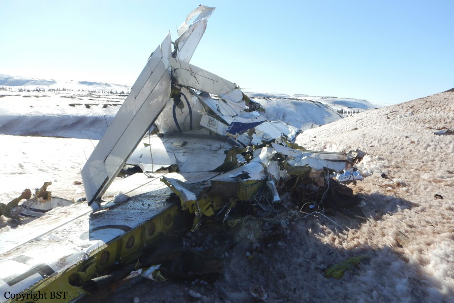
The pilot and two medical crew members departed on an air ambulance flight in night instrument meteorological conditions to pick up a patient. After departure, the local air traffic controller observed the airplane's primary radar target with an incorrect transponder code in a right turn and climbing through 4,400 ft mean sea level (msl), which was 800 ft above ground level (agl). The controller instructed the pilot to reset the transponder to the correct code, and the airplane leveled off between 4,400 ft and 4,600 ft msl for about 30 seconds. The controller then confirmed that the airplane was being tracked on radar with the correct transponder code; the airplane resumed its climb at a rate of about 6,000 ft per minute (fpm) to 6,000 ft msl. The pilot changed frequencies as instructed, then contacted departure control and reported "with you at 6,000 [ft msl]" and the departure controller radar-identified the airplane. About 1 minute later, the departure controller advised the pilot that he was no longer receiving the airplane's transponder; the pilot did not respond, and there were no further recorded transmissions from the pilot. Radar data showed the airplane descending rapidly at a rate that reached 17,000 fpm. Surveillance video from a nearby truck stop recorded lights from the airplane descending at an angle of about 45° followed by an explosion. The airplane impacted a pasture about 1.5 nautical miles south of the airport, and a post impact fire ensued. All major components of the airplane were located within the debris field. Ground scars at the accident site and damage to the airplane indicated that the airplane was in a steep, nose-low and wings-level attitude at the time of impact. The airplane's steep descent and its impact attitude are consistent with a loss of control. An airplane performance study based on radar data and simulations determined that, during the climb to 6,000 ft and about 37 seconds before impact, the airplane achieved a peak pitch angle of about 23°, after which the pitch angle decreased steadily to an estimated -42° at impact. As the pitch angle decreased, the roll angle increased steadily to the left, reaching an estimated -76° at impact. The performance study revealed that the airplane could fly the accident flight trajectory without experiencing an aerodynamic stall. The apparent pitch and roll angles, which represent the attitude a pilot would "feel" the airplane to be in based on his vestibular and kinesthetic perception of the components of the load factor vector in his own body coordinate system, were calculated. The apparent pitch angle ranged from 0° to 15° as the real pitch angle steadily decreased to -42°, and the apparent roll angle ranged from 0° to -4° as the real roll angle increased to -78°. This suggests that even when the airplane was in a steeply banked descent, conditions were present that could have produced a somatogravic illusion of level flight and resulted in spatial disorientation of the pilot. Analysis of the performance study and the airplane's flight track revealed that the pilot executed several non-standard actions during the departure to include: excessive pitch and roll angles, rapid climb, unexpected level-offs, and non-standard ATC communications. In addition to the non-standard actions, the pilot's limited recent flight experience in night IFR conditions, and moderate turbulence would have been conducive to the onset of spatial disorientation. The pilot's failure to set the correct transponder code before departure, his non-standard departure maneuvering, and his apparent confusion regarding his altitude indicate a mental state not at peak acuity, further increasing the chances of spatial disorientation. A post accident examination of the flight control system did not reveal evidence of any preimpact anomalies that would have prevented normal operation. The engine exhibited rotational signatures indicative of engine operation during impact, and an examination did not reveal any preimpact anomalies that would have precluded normal engine operation. The damage to the propeller hub and blades indicated that the propeller was operating under high power in the normal range of operation at time of impact. Review of recorded data recovered from airplane's attitude and heading reference unit did not reveal any faults with the airplane's attitude and heading reference system (AHRS) during the accident flight, and there were no maintenance logbook entries indicating any previous electronic attitude director indicator (EADI) or AHRS malfunctions. Therefore, it is unlikely that erroneous attitude information was displayed on the EADI that could have misled the pilot concerning the actual attitude of the airplane. A light bulb filament analysis of the airplane's central advisory display unit (CADU) revealed that the "autopilot disengage" caution indicator was likely illuminated at impact, and the "autopilot trim" warning indicator was likely not illuminated. A filament analysis of the autopilot mode controller revealed that the "autopilot," "yaw damper," and "altitude hold" indicators were likely not illuminated at impact. The status of the "trim" warning indicator on the autopilot mode controller could not be determined because the filaments of the indicator's bulbs were missing. However, since the CADU's "autopilot trim" warning indicator was likely not illuminated, the mode controller's "trim" warning indicator was also likely not illuminated at impact. Exemplar airplane testing revealed that the "autopilot disengage" caution indicator would only illuminate if the autopilot had been engaged and then disconnected. It would not illuminate if the autopilot was off without being previously engaged nor would it illuminate if the pilot attempted and failed to engage the autopilot by pressing the "autopilot" push button on the mode controller. Since the "autopilot disengage" caution indicator would remain illuminated for 30 seconds after the autopilot was disengaged and was likely illuminated at impact, it is likely that the autopilot had been engaged at some point during the flight and disengaged within 30 seconds of the impact; the pilot was reporting to ATC at 6,000 ft about 30 seconds before impact and then the rapid descent began. The airplane was not equipped with a recording device that would have recorded the operational status of the autopilot, and the investigation could not determine the precise times at which autopilot engagement and disengagement occurred. However, these times can be estimated as follows:
- The pilot likely engaged the autopilot after the airplane climbed through 1,000 ft agl about 46 seconds after takeoff, because this was the recommended minimum autopilot engagement altitude that he was taught.
- According to the airplane performance study, the airplane's acceleration exceeded the autopilot's limit load factor of +1.6 g about 9 seconds before impact. If it was engaged at this time, the autopilot would have automatically disengaged.
- The roll angle data from the performance study were consistent with engagement of the autopilot between two points:
1) about 31 seconds before impact, during climb, when the bank angle, which had stabilized for a few seconds, started to increase again and
2) about 9 seconds before impact, during descent, at which time the autopilot would have automatically disengaged. Since the autopilot would have reduced the bank angle as soon as it was engaged and there is no evidence of the bank angle reducing significantly between these two points, it is likely that the autopilot was engaged closer to the latter point than the former. Engagement of the autopilot shortly before the latter point would have left little time for the autopilot to reduce the bank angle before it would have disengaged automatically due to exceedance of the normal load factor limit. Therefore, it is likely that the pilot engaged the autopilot a few seconds before it automatically disconnected about 9 seconds before impact. The operator reported that the airplane had experienced repeated, unexpected, in-flight autopilot disconnects, and, two days before the accident, the chief pilot recorded a video of the autopilot disconnecting during a flight. Exemplar airplane testing and maintenance information revealed that, during the flight in which the video was recorded, the autopilot's pitch trim adapter likely experienced a momentary loss of power for undetermined reasons, which resulted in the sequence of events observed in the video. It is possible that the autopilot disconnected during the accident flight due to the pitch trim adapter experiencing a loss of power, which would have to have occurred between 30 and 9 seconds before impact. A post accident weather analysis revealed that the airplane was operating in an environment requiring instruments to navigate, but it could not be determined if the airplane was in cloud when the loss of control occurred. The sustained surface wind was from the north at 21 knots with gusts up to 28 knots, and moderate turbulence existed. The presence of the moderate turbulence could have contributed to the controllability of the airplane and the pilot's inability to recognize the airplane's attitude and the autopilot's operational status.
Probable cause:
The pilot's loss of airplane control due to spatial disorientation during the initial climb after takeoff in night instrument meteorological conditions and moderate turbulence.
Final Report: