Crash of a Piper PA-31P Pressurized Navajo in El Dorado: 1 killed

Date & Time: Feb 26, 1984 at 1430 LT
Type of aircraft:
Registration:
N33BP
Survivors:
Yes
Schedule:
Memphis – El Dorado – Vivian
MSN:
31-7400197
YOM:
1974
Crew on board:
1
Crew fatalities:
Pax on board:
1
Pax fatalities:
Other fatalities:
Total fatalities:
1
Captain / Total flying hours:
6000
Captain / Total hours on type:
75.00
Aircraft flight hours:
2328
Circumstances:
The aircraft crashed into trees 2 miles short of the runway during an instrument approach in IMC weather. A pilot in the right front seat said that just prior to impact, the aircraft was descending at 2,500 fpm, and when he looked ahead, he saw trees. He said he yelled at the pilot to 'pull up' but the pilot did not react. The pilot was killed and the passengers was injured.
Probable cause:
Occurrence #1: in flight collision with object
Phase of operation: approach - faf/outer marker to threshold (IFR)
Findings
1. (f) weather condition - low ceiling
2. (f) weather condition - rain
3. (f) weather condition - fog
4. (c) ifr procedure - improper - pilot in command
5. (c) minimum descent altitude - below - pilot in command
6. Missed approach - not performed - pilot in command
7. (f) object - tree(s)
Final Report:

Crash of a Cessna 425 Conquest in Ithaca

Date & Time: Feb 25, 1984 at 1050 LT
Type of aircraft:
Registration:
N6886D
Survivors:
Yes
Schedule:
Worcester - Ithaca
MSN:
425-0152
YOM:
1982
Crew on board:
1
Crew fatalities:
Pax on board:
1
Pax fatalities:
Other fatalities:
Total fatalities:
0
Captain / Total flying hours:
3541
Captain / Total hours on type:
401.00
Circumstances:
The pilot stated that he was utilizing the autopilot and flight director to execute the ILS approach to runway 32. The autopilot was tracking the localizer while the pilot controlled the rate of descent along the glideslope with pitch command wheel on the autopilot, using the command bars as a steering reference in addition to the raw data glideslope needle on the hsi. All seemed normal, according to the pilot, until the aircraft struck trees about 450 feet above airport elevation two miles short of the runway and came to rest on the localizer centerline. A zero feet ceiling with an eighth mile visibility existed at the airport. During the investigations, it was determined that the 1000 a ifcs will not provide vertical steering commands as operated by the pilot, but is driven by the pitch wheel. This is not specifically stated in the poh. The pilot had flown extensively with the 800 series ifcs which will provide the expected steering commands. Extensive damage precluded a functional test of the raw data glideslope needle. Both occupants were slightly injured.
Probable cause:
Occurrence #1: in flight collision with terrain/water
Phase of operation: approach - faf/outer marker to threshold (IFR)
Findings
1. (c) proper glidepath - not maintained - pilot in command
2. (c) reason for occurrence undetermined
3. (f) flight/navigation instrument(s) - improper use of - pilot in command
4. (f) weather condition - below approach/landing minimums
----------
Occurrence #2: fire
Phase of operation: other
Final Report:

Crash of a Cessna 414A Chancellor in Mena: 2 killed

Date & Time: Feb 15, 1984 at 1656 LT
Type of aircraft:
Operator:
Registration:
N6815Z
Flight Type:
Survivors:
No
Schedule:
Addison - Mena
MSN:
414A-0648
YOM:
1981
Location:
Crew on board:
1
Crew fatalities:
Pax on board:
1
Pax fatalities:
Other fatalities:
Total fatalities:
2
Captain / Total flying hours:
10100
Aircraft flight hours:
411
Circumstances:
The aircraft was cleared for Mena NDB approach and to maintain 5,000 feet msl until established on the approach. Aircraft descended to 4,800 feet msl on approximately ground track of 040° to 030° after NDB passage. Aircraft then turned to a ground track of 116°. After 12 seconds the aircraft turned to a ground track of 350° during which the ground speed decreased to 93 knots. The aircraft descended to 4,600 feet msl with ground speed increasing to 140 knots. N68152 reported 'we've broken below - will cancel in just a moment.' Radar contact was lost with the aircraft descending to 3,000 feet msl on a heading of 304°. The wreckage was found 6 miles northwest of the airport at an elevation of 2,000 feet msl. The outbound approach heading is 080° with procedure turn heading of 125° and 305°. Reported winds aloft at 5,000 feet msl, 4,000 feet msl and 3,000 feet msl were 191° at 34 knots, 169° at 30 knots and 151° at 32 knots respectively. Both occupants were killed.
Probable cause:
Occurrence #1: in flight collision with object
Phase of operation: approach - faf/outer marker to threshold (IFR)
Findings
1. (f) compensation for wind conditions - not performed - pilot in command
2. (f) minimum descent altitude - not attained - pilot in command
3. (c) ifr procedure - not followed - pilot in command
4. (f) terrain condition - mountainous/hilly
5. (f) weather condition - low ceiling
6. (f) object - tree(s)
Final Report:

Crash of a PA-31P Pressurized Navajo in Presidio

Date & Time: Feb 15, 1984 at 1240 LT
Type of aircraft:
Registration:
N3PN
Flight Type:
Survivors:
Yes
MSN:
31-70
YOM:
1968
Crew on board:
1
Crew fatalities:
Pax on board:
5
Pax fatalities:
Other fatalities:
Total fatalities:
0
Captain / Total flying hours:
3207
Captain / Total hours on type:
500.00
Aircraft flight hours:
2014
Circumstances:
During a cross country flight the pilot could not locate a refueling stop and landed 100 miles away. No refueling was accomplished and he decided to go on to his destination with the fuel remaining. Enroute his right engine coughed and he realized he was running out of fuel. After switching to crossfeed normal engine operation was restored. Even though he was only about 3 miles from his destination he decided to land on a 4,000 feet dirt agricultural airstrip which he saw directly below him. He forced the aircraft down and landed downwind at high speed about midway down the runway. The aircraft did not stop on the runway and overran into a dirt bank and a fence. The landing gear was knocked off and the aircraft became airborne for 700 more feet before impacting and tumbling. The aircraft came to rest inverted about 825 feet past the dirt bank. A fire developed in the left wing and consumed most of the area in the vicinity of the left fuel tank outboard of the left engine. The pilot stated that there were no malfunctions of the aircraft or systems.
Probable cause:
Occurrence #1: loss of engine power (partial) - nonmechanical
Phase of operation: cruise - normal
Findings
1. (f) fluid,fuel - starvation
2. (c) preflight planning/preparation - inadequate - pilot in command
3. (c) became lost/disoriented - inadvertent - pilot in command
4. (c) in-flight planning/decision - improper - pilot in command
5. (c) refueling - not performed - pilot in command
----------
Occurrence #2: forced landing
Phase of operation: landing - flare/touchdown
Findings
6. (c) precautionary landing - performed - pilot in command
----------
Occurrence #3: overrun
Phase of operation: landing - roll
Findings
7. (f) weather condition - tailwind
8. (c) planned approach - improper - pilot in command
9. (c) airspeed - excessive - pilot in command
10. (c) proper touchdown point - not attained - pilot in command
11. (c) wrong runway - selected - pilot in command
----------
Occurrence #4: nose over
Phase of operation: landing - roll
Findings
12. (f) terrain condition - dirt bank/rising embankment
Final Report:

Crash of a Piper PA-31T-620 Cheyenne II in Riviera

Date & Time: Feb 8, 1984 at 1010 LT
Type of aircraft:
Registration:
N36CA
Flight Phase:
Survivors:
Yes
Schedule:
Bullhead City – Santa Ana
MSN:
31T-7920013
YOM:
1979
Location:
Crew on board:
1
Crew fatalities:
Pax on board:
2
Pax fatalities:
Other fatalities:
Total fatalities:
0
Aircraft flight hours:
1081
Circumstances:
The aircraft lost power on the left engine during climb to cruise approximately 8 minutes after takeoff. Airport manager heard unicom transmission from N36CA, 'we lost an engine, we're coming back.' A warning horn (possibly gear warning or stall horn) was heard in the background of the transmission. When N36CA failed to return the airport manager called the sheriff and began search in his own aircraft. N36CA was located approximately one hour after it's departure. The forced landing was in a flat, wings level attitude with 22° of flaps extended. Initial impact occurred in area of 8 feet high brush. Distance from initial impact to final rest was 595 feet on heading of 140°. Although restrained by lap belt and harness, pilot hit head on copilot's control yoke during the accident. The left eng turbine blade had failed in fatigue. The pilot's son said his father shut down the right engine in-flight and as a result the aircraft had no power on either engine. All three occupants were injured.
Probable cause:
Occurrence #1: loss of engine power (total) - mech failure/malf
Phase of operation: climb - to cruise
Findings
1. (c) turbine assembly,turbine blade - fatigue
2. (c) wrong engine shutdown - performed - pilot in command
3. (c) inadequate training(emergency procedure(s)) - pilot in command
4. (c) turbine assembly,turbine blade - failure,total
5. (c) propeller feathering - not attained - pilot in command
6. (c) emergency procedure - poor - pilot in command
----------
Occurrence #2: forced landing
Phase of operation: descent - emergency
----------
Occurrence #3: in flight collision with terrain/water
Phase of operation: landing - flare/touchdown
Findings
7. (f) terrain condition - high vegetation
Final Report:

Crash of a Cessna 402C in Keene: 2 killed

Date & Time: Feb 3, 1984 at 1713 LT
Type of aircraft:
Operator:
Registration:
N6814G
Flight Phase:
Survivors:
No
Site:
Schedule:
Concord - Morristown
MSN:
402C-0647
YOM:
1982
Crew on board:
2
Crew fatalities:
Pax on board:
0
Pax fatalities:
Other fatalities:
Total fatalities:
2
Captain / Total flying hours:
4300
Captain / Total hours on type:
3700.00
Aircraft flight hours:
368
Circumstances:
The pilot had filed an IFR flight plan; however, he took off in VFR conditions and did not activate the flight plan. Radar data showed that the latter part of the flight was flown at 6,300 feet, then at 1712:39 est, a descent was begun. One minute later, the flight was last recorded at 3,700 feet. Subsequently, the aircraft crashed near the top of a 3,165 feet mountain. The elevation of the crash site was about 3,000 feet. The terrain was rocky and covered with ice and snow when the investigators arrived at the crash site. Approximately 8 miles west-northwest at Keene, NH, the 1755 est weather was, in part, 3,200 feet broken, 5,500 feet overcast, visibility 10 miles, wind from 130° at 10 knots. The elevation of the Dillant-Hopkins Airport at Keene was 487 feet. Both occupants were killed.
Probable cause:
Occurrence #1: in flight encounter with weather
Phase of operation: cruise - normal
Findings
1. (f) weather condition - clouds
2. Descent - initiated - pilot in command
3. (f) weather condition - low ceiling
----------
Occurrence #2: in flight collision with terrain/water
Phase of operation: maneuvering
Findings
4. (f) light condition - dusk
5. (c) in-flight planning/decision - improper - pilot in command
6. (f) visual/aural detection - pilot in command
7. (f) terrain condition - high terrain
8. (c) proper altitude - not maintained - pilot in command
9. (f) terrain condition - mountainous/hilly
10. (f) terrain condition - snow covered
Final Report:

Crash of a Learjet 24 on Catalina Island: 6 killed

Date & Time: Jan 30, 1984 at 1330 LT
Type of aircraft:
Operator:
Registration:
N44GA
Flight Type:
Survivors:
No
Schedule:
Santa Rosa - Catalina
MSN:
24-129
YOM:
1966
Crew on board:
2
Crew fatalities:
Pax on board:
4
Pax fatalities:
Other fatalities:
Total fatalities:
6
Captain / Total flying hours:
8000
Captain / Total hours on type:
1100.00
Aircraft flight hours:
3306
Circumstances:
The aircraft departed on a sales demo flight to Monterey, CA with potential buyers aboard. En route, the destination was changed to Avalon, CA. Unicom advised the crew of the wind direction and speed on downwind. Witnesses reported the aircraft was slightly high on final, but said the pilot corrected the angle of descent. The aircraft touched down approximately 500 feet down the runway, which was crowned (sloped upward for approximately the 1st 2,000 feet, then leveled off). The crew could not see the end of the runway at touchdown. The thrust reversers were deployed approximately 1,000 feet after touchdown. Witnesses heard the engine sound increase, then decrease, then increase again as the aircraft went off the runway and over a 90 feet bluff. Fire erupted immediately. Within 3 minutes, airport personnel arrived with firefighting equipment, but they were not trained as firefighters and did not try to stop the fire for fear of an explosion. No evidence of a mechanical failure/malfunction was found. Found left flap extended, left spoiler retracted and locked, tire marks on runway. Estimated gross weight: 11,500 lbs. Computed landing distance over a 50 feet obstacle: 3,100 feet. The aircraft was destroyed and all six occupants were killed.
Probable cause:
Occurrence #1: overrun
Phase of operation: landing - roll
Findings
1. (c) reason for occurrence undetermined
2. (f) improper - pilot in command
3. (f) self-induced pressure - pilot in command
4. (f) pressure induced by others - other person
5. (f) airport facilities, runway/landing area condition - uphill
6. (f) airport facilities, runway/landing area condition - rough/uneven
----------
Occurrence #2: on ground/water encounter with terrain/water
Phase of operation: landing
Findings
7. (f) terrain condition - mountainous/hilly
8. (f) terrain condition - downhill
9. (f) airport fire/rescue service - inadequate
Final Report:

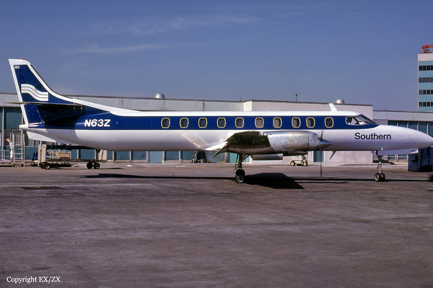
Crash of a Swearingen SA226TC Metro II in Terre Haute: 3 killed

Date & Time: Jan 30, 1984 at 0630 LT
Type of aircraft:
Operator:
Registration:
N63Z
Flight Phase:
Flight Type:
Survivors:
No
Schedule:
Terre Haute - Evansville
MSN:
TC-240
YOM:
1977
Crew on board:
2
Crew fatalities:
Pax on board:
1
Pax fatalities:
Other fatalities:
Total fatalities:
3
Captain / Total flying hours:
19189
Captain / Total hours on type:
1501.00
Aircraft flight hours:
10607
Circumstances:
After taking off from runway 23, the aircraft crashed ssw of the airport about 6,300 feet from the departure end of the runway and about 1,800 feet to the left of the runway centerline. Impact occurred while the aircraft was in a steep descent. The wreckage path was scattered along a heading of 035° from the initial impact point. The aircraft was demolished by impact and fire and no preimpact part failure or malfunction was found that would have caused the accident. All three occupants were killed.
Probable cause:
Occurrence #1: loss of control - in flight
Phase of operation: takeoff
Findings
1. (c) reason for occurrence undetermined
2. Light condition - dawn
3. Weather condition - rain
4. Weather condition - fog
----------
Occurrence #2: in flight collision with terrain/water
Phase of operation: takeoff
Final Report:

Crash of a Mitsubishi MU-2B-20 Marquise in Ames

Date & Time: Jan 24, 1984 at 1055 LT
Type of aircraft:
Operator:
Registration:
N123AX
Survivors:
Yes
Schedule:
Chattanooga - Ames
MSN:
220
YOM:
1972
Location:
Crew on board:
1
Crew fatalities:
Pax on board:
3
Pax fatalities:
Other fatalities:
Total fatalities:
0
Captain / Total flying hours:
10785
Captain / Total hours on type:
327.00
Circumstances:
The aircraft landed in a crosswind on a snow and ice covered runway. During landing, directional control was lost and the aircraft collided with a snowbank. The pilot stated he attempted to use propeller reversing for braking and the aircraft started to slide to the left. All four occupants escaped uninjured while the aircraft was damaged beyond repair.
Probable cause:
Occurrence #1: loss of control - on ground/water
Phase of operation: landing - roll
Findings
1. (f) terrain condition - icy
2. (c) wrong runway - selected - pilot in command
3. (f) terrain condition - snow covered
4. (c) airspeed - improper - pilot in command
5. (f) weather condition - crosswind
6. (c) directional control - not maintained - pilot in command
7. (c) ground loop/swerve - not corrected - pilot in command
----------
Occurrence #2: on ground/water encounter with terrain/water
Phase of operation: landing - roll
Findings
8. (f) terrain condition - snowbank
9. Landing gear - overload
Final Report:

Crash of a Rockwell Grand Commander 690A in Liberty

Date & Time: Jan 20, 1984 at 2350 LT
Registration:
N83MC
Flight Phase:
Flight Type:
Survivors:
Yes
Schedule:
Lorain - Kansas City
MSN:
690-11124
YOM:
1973
Crew on board:
1
Crew fatalities:
Pax on board:
0
Pax fatalities:
Other fatalities:
Total fatalities:
0
Captain / Total flying hours:
6460
Captain / Total hours on type:
510.00
Aircraft flight hours:
39582
Circumstances:
The pilot stated that approximately 15 minutes from his destination the low fuel light illuminated in the cockpit. The aircraft was flown for approximately 10 minutes when the engines sputtered and quit. The pilot stated he 'came in too hot' and bounced off the runway, pulled the gear up looked for a field or road finally coming to rest on a frozen pond. Post accident investigation revealed less than 2 gallons of fuel aboard the aircraft.
Probable cause:
Occurrence #1: loss of engine power(total) - nonmechanical
Phase of operation: cruise - normal
Findings
1. (f) fluid,fuel - exhaustion
2. (c) preflight planning/preparation - improper - pilot in command
3. (c) fuel supply - inadequate - pilot in command
4. (c) fuel consumption calculations - inaccurate - pilot in command
----------
Occurrence #2: forced landing
Phase of operation: landing - flare/touchdown
Findings
5. (f) object - tree(s)
Final Report: